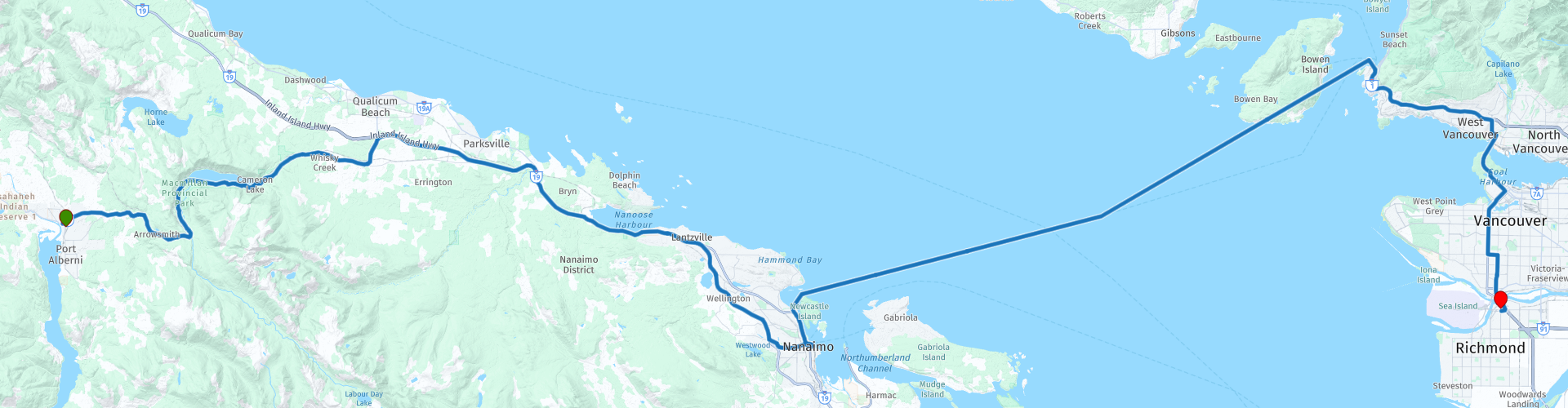
D15 Port Alberni Vancouver

This route was brought to you by:
RouteXpert Hans van de Ven (Mr.MRA)
Last edit: 20-10-2019
 Route Summary
 The roads are good and the views along the way are beautiful, in this route again a crossing with a ferry where you can possibly capture an orca or seal in the photo.
Starting point: Best Western Plus Barclay Hotel
End point: Best Western Plus Abercorn Inn
The route has been made the same for TomTom, Garmin and MyRoute-app Navigation users.
Thanks to Richard & Lisa for the information!
 Share this route


Animation

Verdict


Duration
3h 58m

Mode of travel
Car or motorcycle

Distance
178.58 km

Countries

 RouteXpert Review
 The road runs from the bay where ferries dock past various bistros, pubs and parks. On the route is the Swy-a-Lana Lagoon, one of the few man-made tidal pools in Canada. A pedestrian bridge runs across the lagoon to Maffeo Sutton Park. Festivals are often held here in the summer and you will find local artists offering their work for sale.
Snowy mountains, rainforests and rugged coastlines can be found in the immediate vicinity of Vancouver. Famous attractions are Stanley Park with its totem poles, the Lookout Tower, Granville Island and the Capilano Suspension Bridge, a long suspension bridge over a ravine. The city consists of several districts with their own character. One example is Chinatown, one of the largest Chinese neighborhoods in North America, also known as 'Hongcouver'.
Chinatown:
One of the largest Chinatowns in North America is no longer a primary residential area, but a shopping area with countless sights. Highlights are the Dr. Sun Yat-Sen Classical Chinese Gardens, the Chinese Cultural Museum, Vancouver Chinatown Millennium Gate (a large entrance gate) and Sam Kee Building (with 1.80 meters in width the narrowest house in the city). Chinatown came into being when many Chinese immigrants settled in the early twentieth century who were working in the mining or railroad industries.
Gastown:
Gastown is a historic neighborhood, northeast of downtown. There are many relics from the heyday of the Canadian Pacific Railway in this part of the city, since the end point was in this neighborhood. It is recommended for those who want to taste the atmosphere from the pioneering period. The most famous attraction is the Gastown Steam Clock, a clock that runs on steam and produces a melody every 15 minutes. Maple Tree Square is also known. A monument has been erected here for Gassy Jack, the pioneer who started a saloon with a barrel of whiskey as the most precious possession. In Water Street you will find many occasions where live music is performed.
Granville Island:
This peninsula is in a special location, in the middle of the city. There are restaurants on the water, theaters, galleries, boutiques, cafés and a large market with fresh food (Granville Public Market). The Granville Island Museum consists of three smaller museums; the Model Trains Museum (model railway lines), the Model Ship Museum (scale models of boats) and the Sportfishing Museum (fishing).
Granville Street:
The Granville Entertainment District consists of seven blocks along Granville Street. Here you will find busy clubs, various bars and cafés that offer a wide range of music: from the more famous jazz performances to local bands. One of the most important sights is The Commodore Ballroom, an atmospheric art deco music hall where famous names have stood in the past 75 years, including Tina Turner, The Police and Snoop Dogg.
Stanley Park:
The majority of the eight million annual visitors use the approximately ten kilometer long road around the park. In the park there are more than half a million trees that are hundreds of years old (hemlock and douglass firs) and some of which have reached a height of 76 meters. The park has approximately two hundred kilometers of paths and roads, making it an important recreational place for the people of Vancouver. The nine totem poles at Brockton Point are famous.
Vancouver Lookout:
A glass elevator takes you to an observation platform at around 160 meters in forty seconds. You have good views of the historic Gastown district and the bustling Coal Harbor. Stanley Park, the Pacific Ocean, the North Shore Mountains and the Olympic Peninsula Mountains can also be seen. You can participate in guided tours and learn everything about the history, present and future of Vancouver. Capilano Suspension Bridge: In North Vancouver, past Stanley Park and the Lions Gate Bridge, lies Capilano Park, with the Capilano Suspension Bridge as the highlight. This suspension bridge was built in 1889
is built eighty meters high and spans 135 meters over the deep canyon through which the Capilano River flows.
Grouse Mountain:
Grouse Mountain is a few minutes' drive from the Capilano Bridge. The Skyline cable car takes you to the top of the mountain, also known as The Peak of Vancouver. Here you have a wonderful view of the city and the delta of the Fraser River. Beautiful hiking trails start at the top of the mountain, of which the Blue Grouse Interpretive Trail (to Lake Blue Grouse) is the easiest. At the lake stands the Híwus Feasthouse of the Salish Indians. In the evening there are
dancing and you can enjoy Indian cuisine. You can also visit the Wildlife Refuge. Grizzly bears, birds of prey and wolves live here.
Fort Langley National Historic Site: Built in 1827 (east of today's center), the fort was the first European settlement near present-day Vancouver and was one of the most important forts of the Hudson's Bay Company. Trade with the First Nations was checked from here. It is sometimes said that the history of British Columbia began with the construction of this fort. From this trading post, merchandise (mainly furs, cranberries and salmon from the Fraser River) was shipped to Europe and California, among others. Nowadays there are a few old buildings on display.
The 'residents' look the same as the former traders and work in the same clothing and with the same materials. The buildings are furnished with furniture and utensils from the nineteenth century.
In this 4 star route you drive on beautiful good roads, through a beautiful environment, long stop on the Harbourfront Walkway you should definitely do.
History:
The history of Vancouver began thousands of years ago with the foundation of the first settlements of the indigenous people. Only at the end of the sixteenth century did the first Europeans appear. It was Spanish explorers who explored the Canadian west coast. In 1792 the English captain George arrived in Vancouver. He met the Spaniards (the place is now called Spanish Banks and English Bay) and instructed them to leave. George Vancouver claimed the area in the name of the British crown.
Simon Fraser, sales representative of the North West Company (at that time the big competitor of the Hudson's Bay Company), was in 1808 the first European to reach the west coast from the east via the interior. This is how the Fraser River got its name. In 1821 the North West Company merged with the Hudson's Bay Company and six years later a trading post was built on the Fraser River; Fort Langley. The trading post was the first non-native branch in the Vancouver region and was very important in opening up the province of British Columbia. First they checked trade with the Indians from Fort Langley and traders sought protection there. Then settlers on the way inland visited the fort and later the gold seekers followed. The latter group ensured that the settlement at Fort Langley in 1858 rapidly changed into a bustling village. The gold rush brought tens of thousands of people to the west coast of Canada. John Deighton, nicknamed 'Gassy Jack', opened a saloon for foresters in 1867. His saloon became so popular that there was a community around it: Gastown.
The Great Vancouver Fire raged at the end of the nineteenth century, which destroyed almost the entire city in half an hour. During the reconstruction, substantial investments were made in equipment for the fire brigade and water tanks. The Canadian Pacific Railway also connected the city to the east of the country before the turn of the century. The terminus of the railway was the Waterfront Station, located in Gastown. This gave this neighborhood a major boost.
In the fifties and sixties of the twentieth century Vancouver grew so fast that there was a lack of space. The first skyscrapers therefore sprouted like mushrooms. This made Downtown Vancouver a compact and accessible city center, suitable for public transport, cyclists and walkers. In 1983 Canada's first indoor stadium opened: the BC Place Stadium. Three years later, Vancouver was the scene of the Expo 86, which at the time attracted 22 million visitors. A recent major event in Vancouver were the Winter Olympics in 2010.
Vancouver is now Canada's second largest city and half of the total population of British Columbia lives in the conurbation. It is the gateway to the Pacific Ocean and therefore the province's trade center and also an important hub for air, train and bus traffic. In addition to industry and the transport sector, the ICT sector, biotechnology and film industry are on the rise. Thanks to the latter sector, Vancouver has been nicknamed 'Hollywood of the North'.


 Links
Links  Usage
Usage Want to download this route?
You can download the route for free without MyRoute-app account. To do so, open the route and click 'save as'. Want to edit this route?
No problem, start by opening the route. Follow the tutorial and create your personal MyRoute-app account. After registration, your trial starts automatically.  Disclaimer
Use of this GPS route is at your own expense and risk. The route has been carefully composed and checked by a MyRoute-app accredited RouteXpert for use on TomTom, Garmin and MyRoute-app Navigation.
Changes may nevertheless have occurred due to changed circumstances, road diversions or seasonal closures. We therefore recommend checking each route before use.
Preferably use the route track in your navigation system. More information about the use of MyRoute-app can be found on the website under 'Community' or 'Academy'.

British Columbia
About this region
British Columbia (BC) is the westernmost province of Canada, situated between the Pacific Ocean and the Rocky Mountains. With an estimated population of 5.2 million as of 2021, it is Canada's third-most populous province. The capital of British Columbia is Victoria, the fifteenth-largest metropolitan region in Canada, named for Queen Victoria, who reigned over the British Empire at the time of Confederation. The largest city is Vancouver, the third-largest metropolitan area in Canada, the largest in Western Canada, and the second-largest in the Pacific Northwest. In October 2013, Greater Vancouver had an estimated population of approximately 2.5 million. Since 2017, the province has been governed by the New Democratic Party, led by John Horgan, first with a minority government elected in 2017 and subsequently with a majority government elected in 2020.
Read more on Wikipedia
View region
 Statistics
  15
15Amount of RX reviews (British Columbia)
 12297
12297Amount of visitors (British Columbia)
 558
558Amount of downloads (British Columbia)
 Route Collections in this region
 Top car and motorcycle tour through Canada USA and the Rockies
Traveling by car or motorcycle through Canada, USA and the Rockies is a journey that you don't just make, so don't drive for 15 days and then return home. No, book a stay of several days in Vancouver, Jasper, Banff, Seattle and Port Alberni and again Vancouver to also visit several places of interest in these cities, so that this tour becomes an unforgettable tour that you can remember with pleasure.
Do not forget to arrange and pack the following items:
*This is only a summary and completely personal and may differ per person.
Take out travel insurance, +31 for numbers in GSM, (partially) take out gas, Health insurance coverage at destination?, Switch off electrical appliances, Lighting (time clock), Check passport validity, Antenna from radio/TV due to lightning, Residence address for those left behind, Remote control house alarm, Book Smart Parking.
Hand luggage:
Liquids in packaging of max. 100 ml, Liquids in hand luggage in transparent plastic bag.
For on the road:
Candy, Book, Earplugs, Country and road map(s), Directions, Maps in your navigation system
Money & Securities:
Bank card / giro card, Credit card (think pin code), Cash, Calculator for Internet banking, Medical insurance card, Travel insurance card.
Travel documents:
Passport, (International) Driver's License, Ticket(s), Reservation Tickets, Hotel Vouchers, Arrival/Departure Time, Check-in & Check-out Times, Valid Visa (ESTA), Travel Guide.
Clothing:
Underwear, Belt, Shirts/ T-shirts, Shorts, Long pants, Shoes, Socks, Swim trunks, Towel, Slippers.
Personal stuff:
Watch, House Keys, Wallet, Sunglasses.
Toiletries:
Deodorant, Shower gel / Soap, Comb / brush, Shaving equipment, Shampoo, Toothbrush, Toothpaste, Sanitary pads
Health & Medicine:
Own medicines, Insect repellent, Cold sore ointment, Ointment for insect bites, Sunscreen, Norit, Paracetamol, Suction cup for insect bites, First aid bag.
Miscellaneous:
Travel bag / waist bag, Leatherman (= checked luggage), Pen or pencil, Headlamp, Lighter, Tools & Electronics, Mobile phone & charger, Photo/video camera & charger, Memory card(s), World plug / adapter, Ipod & charger, Adapter cable Ipod, Headphones, iPad & charger, Navigation & charger/plug, Plug socket, Fuelpack battery.
Engine (accessories):
Helmet, Motorcycle clothing, Motorcycle boots, Chain lock / disc brake lock, Gloves, Bandana, Inner bags (plastic shopping bag), Insulation bag, Tension straps, Tie wraps, Rain suit, Rainaway.
Addresses:
Address list, Embassy telephone number, Telephone number to block (bank) card(s), Telephone number (airline tickets).
View Route Collection
Trans Canada Highway
The Trans-Canada Highway (TCH) or Trans-Canadian Highway is a system of highways that cover all 10 provinces of Canada.
The Federal and Provincial Highways System that now forms the TCH were authorized by the Trans-Canada Highway Act of 1948 and opened in 1962. It was completed in 1971. The total length of the TCH is 7821 km.
Contrary to the American Interstate Highway System, the TCH does not consist of an unambiguous network of motorways, but forms a network of restricted access highways and other main routes that are more akin to the Dutch provincial roads. The route is indicated by a green shield with a white maple leaf.
The numbering of the roads that are part of the TCH is the domain of the provinces. Only the western provinces have aligned their numbering and the TCH has the designation Highway 1 there.
The main route of the TCH starts in Victoria in British Columbia and runs via Calgary and Regina to Winnipeg. From Winnipeg the route leads to Kenora in Ontario, after which several branches pass through Ontario to Ottawa.
Further east, the route passes through the province of Quebec via Montreal and Quebec, among others, to Moncton, New Brunswick. Then the TCH continues east through Nova Scotia, where a branch (via the Confederation Bridge) leads to Prince Edward Island. Another section runs down to the sea in the port city of Sydney, where a ferry service leaves for Channel-Port aux Basques on the island of Newfoundland. From there the route continues for more than 900 km to the provincial capital of St. John's, in the extreme southeast of the island.
We not only drive the TCH, but will take the rural roads as much as possible, because only Highway driving is too boring and Canada has many beautiful roads through its beautiful landscape. You drive through all provinces and through very varied and scenic landscapes, from the Rockies in the West, the Central Prairies to the Eastern Maritimes and the Northern Forest.
The riding season is generally April through October with longer seasons on the west coast and southern Ontario. Provide good all season clothing or bring rain gear, depending on the province and the season the weather can change and you may be surprised by a rain or even a snow or hail shower, so be prepared.
In Canada the metric system is used, so speeds are indicated in Km / h. A helmet requirement (DOT approved) applies throughout Canada.
You will see many wildlife throughout Canada. This varies from province to province, such as deer, buffalos, moose, caribou, wolves, pumas, bears, mountain goats, sheep, lynx, coyotes, foxes, raccoons, badgers, various rodents and all kinds of birds. Even if it is very tempting to stop for a photo, don't do it, it can be very dangerous.
The routes described in this review sometimes deviate from the Trans Canada Highway, bringing the total length to 9,300 kilometers. The routes are made so that you drive through the beautiful parts of Canada with truly beautiful panoramas and beautiful sights to visit, this differs from museums, parks to historical points. The routes are not too long so there is time to stop for photos and sights along the way. You can also choose to arrange and combine the stages differently or to add other routes to shorten or extend your journey. The routes are marked with a rating in stars, some routes are less challenging or interesting but are necessary to drive to the next point, which is why they often have a lower rating.
In the route description you will find more details about the routes and the points of interest along the way. These points and also hotels, restaurants, petrol stations etc. are indicated with a POI and sometimes also with a Route point. In the description you will also find links to interesting sites and to the routes that connect to that day.
The described routes are;
Day 01 TCH Victory to Nanaimo
Day 02 TCH Nanaimo to Hope
Day 03 TCH Hope to Kamloops
Day 04 TCH Kamloops to Revelstoke
Day 05 TCH Revelstoke to Lake Louise
Day 06 TCH Lake Louise to Calgary
Day 07 TCH Calgary to Medicine Hat
Day 08 TCH Medicine Hat to Moose Jaw
Day 09 TCH Moose Jaw to Regina
Day 10 TCH Regina to Brandon
Day 11 TCH Brandon to Winnipeg
Day 12 TCH Winnipeg to Kenora
Day 13 TCH Kenora to Ignace
Day 14 TCH Ignace to Thunder Bay
Day 15 TCH Thunder Bay to Marathon
Day 16 Thunder Bay to Wawa
Day 17 TCH Wawa to Sault Ste Marie
Day 18 TCH Sault Ste Marie to Espanola
Day 19 TCH Espanola to Mattawa
Day 20 TCH Mattawa to Ottawa
Day 21 TCH Ottawa to Montreal
Day 22 TCH Montreal to Quebec
Day 23 TCH Quebec to Riviere du Loup
Day 24 TCH Riviere du Loup to Grand Falls
Day 25 TCH Grand Falls to Fredericton
Day 26 TCH Fredericton to Moncton
Day 27 TCH Moncton to Charlottetown
Day 28 TCH Charlottetown to Truro
Day 29 TCH Truro to North Sydney
Day 30 TCH North Sydney to Corner Brook
Day 31 TCH Corner Brook to Grand Falls
Day 32 TCH Grand Falls to Clarenville
Day 33 TCH Clarenville to St John.
Have fun reading the reviews and planning your next road trip.
If you have driven this trip, I am very curious about your feedback!
View Route Collection