D08 Cody Yellowstone NP

This route was brought to you by:
RouteXpert Hans van de Ven (Mr.MRA)
Last edit: 02-05-2021
 Route Summary
 The roads are good and the views then wide and then frightening again, but always very beautiful, a long day with many stops to take pictures.
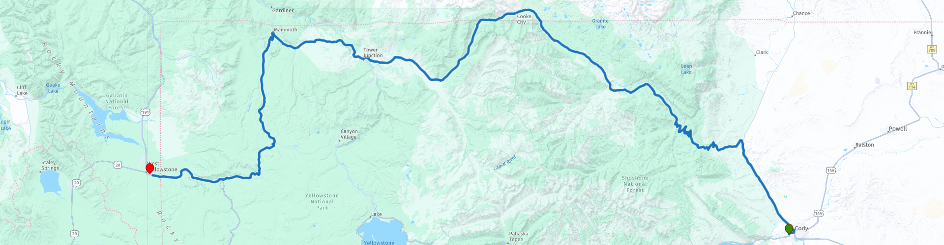
Starting point: BEST WESTERN Sunset Motor Inn
End point: Best Western Weston Inn.
The route has been made the same for TomTom, Garmin and MyRoute-app Navigation users.
Thanks to Richard & Lisa for the information!
 Share this route


Animation

Verdict


Duration
9h 47m

Mode of travel
Car or motorcycle

Distance
285.91 km

Countries

 RouteXpert Review
 spray dozens of meters of boiling and steaming water into the air. Grizzly bears, wolves, bison and wapiti deer live among other things. The most important route is the approximately 240 kilometer long (paved) 8-shaped Loop Road.
We start the route in the Shoshone National Forest, this is the first federally protected National Forest in the United States and covers nearly 2,500,000 hectares in the state of Wyoming. The first stop we do is at Dead Indian Overlook, you should definitely stop here. The view offers a wonderful view of the valley and the surrounding mountain peaks. The squirrels that are used to people will come to you hoping to get some food, it is better not to do this and let them find their natural food themselves. If it is not windy during your visit, you have experienced a rare moment. We drive on and soon arrive at the next stop, Sunlight Bridge Overlook, which offers an impressive view of an almost 90 meter deep gorge formed by Sunlight Creek that cuts through the granite. Because the gap is narrow, it is impossible to see the depth of the gap from your motorcycle - it is certainly worth the effort to park the motorcycle to enjoy the view.
The next longer stop is at Beartooth Cafe, you can stop here for coffee or lunch. This is located in the center of Soda Butte Valley and you have a nice view of the Beartooth Mountains. The next stop is at the Soda Butte Cone, the name "Soda Butte" comes from a large, largely dormant, hot spring cone that sits right next to the highway where Soda Butte Creek ends up in the Lamar Valley. The last wolves killed in Yellowstone during the eradication period of the wolves were killed near this hot spring cone. Nowadays wolves live in the area again.
We are now driving in Yellowstone National Park, which has an area of 8983 km², making it one of the largest national parks in the United States. We continue and then stop at the Forces of the Northern Range, walk this 1/2-mile Self-Guiding Trail on the Blacktail Deer Plateau and see and read how the forces of nature have shaped the land for you. We then stop in Mammoth for a drink while looking out at Capitol Hill. We also visit the Hot Springs Terraces, a large hot springs complex on a travertine hill in Yellowstone National Park adjacent to Fort Yellowstone and the historic Mammoth Hot Springs district. It was created for thousands of years as hot spring water cooled and deposited calcium carbonate.
We also stop at the Museum of the National Park Ranger, to visit the exhibitions about the history of the National Park Service and the forester. We also make a short stop at the Norris Geyser Basin Museum. Furthermore we stop at Gibbon Falls to take some pictures, here the water falls 26 meters down. The last stop before refueling and at the hotel is the viewpoint on Mount Haynes an impressive mountain of 2,505 meters.
In this 4-star route you will drive on beautiful good roads, a stop at Dead Indian Overlook and Soda Butte Cone is a must.
History:
Yellowstone is situated on an exceptionally large volcanic structure; the Yellowstone caldera. The caldera was formed 640,000 years ago during the last eruption. The enormous amount of ash and rock (1,000 km³) that was released during this period covered the entire west of the United States. A crater of 48 kilometers wide and 72 kilometers long was created. The volcanic system is still active, although scientists consider it unlikely that the volcano will erupt again in a short time. The geysers and hot springs in the park are direct proofs of the volcanic activity. The region was once nicknamed: "the area where hell is bubbling up."
In the nineteenth century the first furriers and pioneers discovered Yellowstone. Their imaginative stories about boilers full of simmering mud and steaming geysers reaching the sky soon reached the east coast of America. In 1871, Ferdinand Hayden led an expedition to Yellowstone, which included the painter Thomas Moran and the photographer William H. Jackson. They brought back images that convinced the government that the area needed to be protected and preserved. In 1872, President Ulysses Grant signed a law that declared Yellowstone to be forever a "public park for the good of people's enjoyment." The first US national park was born!
Yellowstone National Park made world news in 1988 with the most devastating forest fires in its history. After an unprecedented dry and hot summer, 36 percent of the park was destroyed. Seeing the charred forests, the whole country feared the worst for the National Park Service flagship. But what appeared on television as the darkest hour in Yellowstone's history was only the dramatic high point of a natural ecological cycle. The fire brigade did its best to control the sea of fire as much as possible, but eventually let nature take its course in a controlled manner. The fires would rage for a long time, until rain in the autumn the fire died out. We now know that the dead trees have made way for young growth, which can again grow into a healthy forest unhindered. Whoever enters Yellowstone can still see the old burnt trees here and there, sometimes they form a spooky backdrop against the backdrop of limestone rocks.


 Links
Links  Usage
Usage Want to download this route?
You can download the route for free without MyRoute-app account. To do so, open the route and click 'save as'. Want to edit this route?
No problem, start by opening the route. Follow the tutorial and create your personal MyRoute-app account. After registration, your trial starts automatically.  Disclaimer
Use of this GPS route is at your own expense and risk. The route has been carefully composed and checked by a MyRoute-app accredited RouteXpert for use on TomTom, Garmin and MyRoute-app Navigation.
Changes may nevertheless have occurred due to changed circumstances, road diversions or seasonal closures. We therefore recommend checking each route before use.
Preferably use the route track in your navigation system. More information about the use of MyRoute-app can be found on the website under 'Community' or 'Academy'.

Wyoming
About this region
Wyoming is a state in the Mountain West subregion of the Western United States. The 10th largest state by area, it is also the least populous and least densely populated state in the contiguous United States. It is bordered by Montana to the north and northwest, South Dakota and Nebraska to the east, Idaho to the west, Utah to the southwest, and Colorado to the south. The state population was 576,851 at the 2020 United States census, making it the least populated U.S. state. The state capital and the most populous city is Cheyenne, which had an estimated population of 63,957 in 2018.Wyoming's western half is mostly covered by the ranges and rangelands of the Rocky Mountains, while the eastern half of the state is high-elevation prairie called the High Plains. It is drier and windier than the rest of the country, being split between semi-arid and continental climates with greater temperature extremes. Almost half of the land in Wyoming is owned by the federal government, leading the state to rank 6th by area and fifth by proportion of a state's land owned by the federal government. Federal lands include two national parks—Grand Teton and Yellowstone—two national recreation areas, two national monuments, several national forests, historic sites, fish hatcheries, and wildlife refuges.
Original inhabitants of the region include the Arapaho, Crow, Lakota, and Shoshone. Southwest Wyoming was claimed by the Spanish Empire and then as Mexican territory until it was ceded to the U.S. in 1848 at the end of the Mexican–American War. The region acquired the name "Wyoming" when a bill was introduced to Congress in 1865 to provide a temporary government for the territory of Wyoming. The name had been used earlier for the Wyoming Valley in Pennsylvania, and is derived from the Munsee word xwé:wamənk, meaning "at the big river flat".Wyoming's economy is driven by tourism and the extraction of minerals such as coal, natural gas, oil, and trona. Agricultural commodities include barley, hay, livestock, sugar beets, wheat, and wool. It was the first state to allow women the right to vote and become politicians, as well as the first state to elect a female governor. Due to this part of its history, its main nickname is "The Equality State" and its official state motto is "Equal Rights". It has been a politically conservative state since the 1950s, with the Republican presidential nominee carrying the state in every election since 1968. A notable exception is Teton County, which has achieved notability for being Wyoming's most Democratic county and the only county in the state to be won by a Democrat in every election since 2004.
Read more on Wikipedia
Original inhabitants of the region include the Arapaho, Crow, Lakota, and Shoshone. Southwest Wyoming was claimed by the Spanish Empire and then as Mexican territory until it was ceded to the U.S. in 1848 at the end of the Mexican–American War. The region acquired the name "Wyoming" when a bill was introduced to Congress in 1865 to provide a temporary government for the territory of Wyoming. The name had been used earlier for the Wyoming Valley in Pennsylvania, and is derived from the Munsee word xwé:wamənk, meaning "at the big river flat".Wyoming's economy is driven by tourism and the extraction of minerals such as coal, natural gas, oil, and trona. Agricultural commodities include barley, hay, livestock, sugar beets, wheat, and wool. It was the first state to allow women the right to vote and become politicians, as well as the first state to elect a female governor. Due to this part of its history, its main nickname is "The Equality State" and its official state motto is "Equal Rights". It has been a politically conservative state since the 1950s, with the Republican presidential nominee carrying the state in every election since 1968. A notable exception is Teton County, which has achieved notability for being Wyoming's most Democratic county and the only county in the state to be won by a Democrat in every election since 2004.
View region
 Statistics
  20
20Amount of RX reviews (Wyoming)
 15457
15457Amount of visitors (Wyoming)
 321
321Amount of downloads (Wyoming)
 Route Collections in this region
 Top car and motorcycle tour through the Midwest of the USA
By car or motorcycle through the Midwest of America is a journey that you do not just make, so it is not a 13-day drive and then back home. No, book a stay of several days in Denver, Cheyenne, Rapid City (In August the Sturgis Bike Ralley, stay there for a day or 4), Yellowstone National Park, Estes Park and again Denver to also visit several places of interest in these cities, so that this tour becomes an unforgettable tour that you can remember with pleasure.
Do not forget to arrange and pack the following items:
*This is only a summary and completely personal and may differ per person.
Take out travel insurance, +31 for numbers in GSM, (partially) take out gas, Health insurance coverage at destination?, Switch off electrical appliances, Lighting (time clock), Check passport validity, Antenna from radio/TV due to lightning, Residence address for those left behind, Remote control house alarm, Book Smart Parking.
Hand luggage:
Liquids in packaging of max. 100 ml, Liquids in hand luggage in transparent plastic bag.
For on the road:
Candy, Book, Earplugs, Country and road map(s), Directions, Maps in your navigation system
Money & Securities:
Bank card / giro card, Credit card (think pin code), Cash, Calculator for Internet banking, Medical insurance card, Travel insurance card.
Travel documents:
Passport, (International) Driver's License, Ticket(s), Reservation Tickets, Hotel Vouchers, Arrival/Departure Time, Check-in & Check-out Times, Valid Visa (ESTA), Travel Guide.
Clothing:
Underwear, Belt, Shirts/ T-shirts, Shorts, Long pants, Shoes, Socks, Swim trunks, Towel, Slippers.
Personal stuff:
Watch, House Keys, Wallet, Sunglasses.
Toiletries:
Deodorant, Shower gel / Soap, Comb / brush, Shaving equipment, Shampoo, Toothbrush, Toothpaste, Sanitary pads
Health & Medicine:
Own medicines, Insect repellent, Cold sore ointment, Ointment for insect bites, Sunscreen, Norit, Paracetamol, Suction cup for insect bites, First aid bag.
Miscellaneous:
Travel bag / waist bag, Leatherman (= checked luggage), Pen or pencil, Headlamp, Lighter, Tools & Electronics, Mobile phone & charger, Photo/video camera & charger, Memory card(s), World plug / adapter, Ipod & charger, Adapter cable Ipod, Headphones, iPad & charger, Navigation & charger/plug, Plug socket, Fuelpack battery.
Engine (accessories):
Helmet, Motorcycle clothing, Motorcycle boots, Chain lock / disc brake lock, Gloves, Bandana, Inner bags (plastic shopping bag), Insulation bag, Tension straps, Tie wraps, Rain suit, Rainaway.
Addresses:
Address list, Embassy telephone number, Telephone number to block (bank) card(s), Telephone number (airline tickets).
View Route Collection
The 10 most downloaded routes in the USA from RouteXpert Hans van de Ven
Hello and welcome to this collection of the Top 10 MyRoute app downloaded routes in USA.
There will be a great new event to be announced soon, where all these routes can be driven.
Download them all now and place them in a new "Top 10" folder, so that you always have them at hand.
If you are going to drive one of these routes in the meantime, track them with the MRA Mobile App or with MRA Navigation. Take some photos (moments) along the way as these will come in handy.
Create a travelogue of your Top 10 driven routes and add the recorded track to it.
There will also be some great prizes on offer, so keep an eye on the MRA-RouteXperts page and your mail.
The 10 routes are:
1. D13 Estes Park Denver
2. D03 Chadron Custer
3. D01 Pigeon Forge round trip through the Smokey Mountains
4. D08 Kalispell Sandpoint
5. D10 Colville Wenatchee
6. D09 Sandpoint Colville
7. D04 Custer Wall
8. D11 Wenatchee Seattle
9. D08 Cody Yellowstone NP
10.R13 San Francisco Monterey
View Route Collection