R14 Monterey Santa Barbara

This route was brought to you by:
RouteXpert Hans van de Ven (Mr.MRA)
Last edit: 01-02-2020
 Route Summary
 During this journey you will travel through the following states: California, Arizona, Utah & Nevada.
The roads are good, the views amazing. Wind and Water, sow and enjoy along the coast!
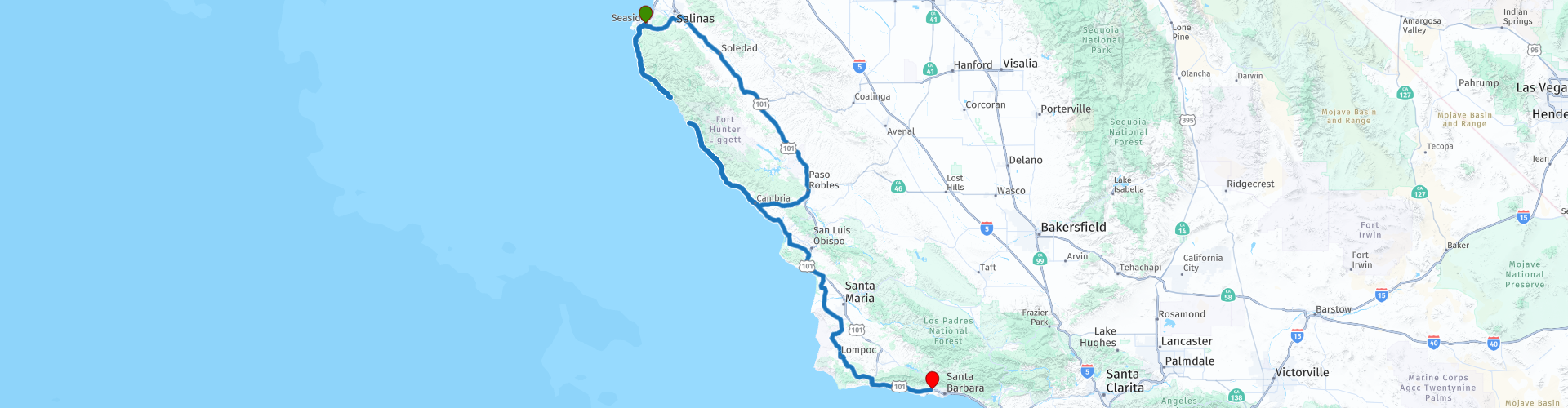
Starting point: Ramada Carmel Hill Monterey.
End point: Ramada Santa Barbara.
The route has been made the same for TomTom, Garmin and MyRoute-app Navigation users.
Thanks to Richard & Lisa for the information!
 Share this route


Animation

Verdict


Duration
5h 10m

Mode of travel
Car or motorcycle

Distance
391.40 km

Countries

 RouteXpert Review
 Big Sur
Bixby Creek Bridge is therefore the gateway to the wilder part of Route One. The bridge itself was built in 1932 and was then the longest concrete bridge in the world. The old coastal road follows the edge of the river to reconnect to Route One at Andrew Molera State Park. This state park is located on the site of one of the first settlements on this stretch of coast. John 'Juan Bautista' Roger Cooper came here in the fifties of the last century, built a cabin and set up a ferry anchor. This is an excellent place to camp.
A little further lies Big Sur (to El Pais Grande del Sur: the large part south of Carmel), the forested valley of the Big Sur River. The village of Big Sur is not much. Until well into the twentieth century it was a hinterland, the only real village between Monterey (Carmel) and Hearst Castle. The name Big Sur is used for the entire stretch of coast between Point Sur Lighthouse and San Simeon (Hearst Castle). Of the entire west coast of the United States, which is actually worth everywhere, this is the most spectacular part, with the mountains rising more than fifteen hundred meters from the sea, in which the road seems to be carved. Big Sur Village was once about the end of civilization. Until 1954 there was no electricity. That made the place attractive for the writer Henry Miller and his friends. Between 1945 and 1962 Miller lived regularly in the hills - the quieter periods of his life. It also attracted the hippies who set up bacchanals here in the 1960s, the journalist Hunter Thompson (better known as Gonzo) then stayed there for a few years. These days it is New Age adepts and ecotourists who moor here.
The views are fantastic but just watching is not enough. Beaches and forests make this an outdoor area; that's the reason people come here. For example, you can take a walk in Julia Pfeiffer Burns State Park for a picnic or visit Pfeiffer Beach.
South of Big Sur begins the stretch of coast that was literally impassable until 1937. The dual carriageway was constructed after twenty years of construction, including by forced laborers (convicted prisoners). The landscape is getting rougher, more impressive. The trees are disappearing and the road that rubs closer and closer to the mountainside demands all the attention. Warnings about rock shifts are not empty shouts - the chance that you have to drive around a sliding part is considerable.
Further on the route, San Simeon (Hearst Castle), south of Big Sur Village is Jules Pfeiffer Burns State Park. The park is located on both sides of Route One and offers, besides a waterfall, beautiful views of the Pacific and, for those who want to take a walk, forests with redwoods on the slopes of the Santa Lucia Mountains.
Route One leads along the coast, via three stopping places that hardly deserve the name village, to San Simeon. Lucia, Pacific Valley and Gorda have petrol and civilians, and it will stop there. Between Pacific Valley and Gorda you will pass a few beautiful beaches where hang gliders regularly drop by in good weather. There are forty kilometers between Gorda and San Simeon with a few smaller state parks but otherwise without facilities.
At the southern end of the Big Sur the mountains become less high and less steep, and gradually rolling hills with grassland dominate. On top of a hill there is Hearst Castle, the bizarre 'castle' that the newspaper magnate built here in the hills. The building is a mess of all kinds of styles and often borders on the kitsch, but nevertheless remains extremely interesting. The historical photos give an extra dimension to what remains of this man and his gigantic taste. There is a small museum in the Visitor center, near where the trains leave that will take you to the house. In the museum a lot about Hearst, his life and the time in which he lived. There are a number of different tours to do through the house. If you are coming for the first time, we recommend the Introductory Tour which shows the house and the two large swimming pools. In addition, there are tours that highlight a specific part of the house or gardens. It is wise to make reservations in advance. Because San Simeon is the most popular destination in California after Disneyland, the town of Cambria, a few kilometers further south, has become quite touristy. For such a busy place it has actually remained pretty nice. And those who spend the night here can nicely split the route along the coast into two parts.
Then you pass Morro Bay, this has as always recognizable point, the large monolith standing in front of the town in the sea - Morro Rock. The thing stands out in such a way that the rock already stood out in 1542 during the first explorations of this coast enough to make a note of it. Morro Bay is a fishing village with quite a few restaurants that know how to make the catch. A kind of lagoon is located south of the city, in Morro Bay State Park, where many birds can be seen.
San Luis Obispo, located approximately midway between San Francisco and Los Angeles, was originally set up entirely around the mission post. Mission San Luis Obispo de Tolosa is said to be the first place where missionaries began their red tile roofs that have now become so characteristic of the entire state as mission style. San Luis, as it is commonly called, is a lively and pleasant town, good for a longer stay. Famous is the Madonna Inn, a high-kitsch decorated motel, with more than a hundred rooms that all differ in terms of theme. San Luis can also boast the world's only Bubble Gum Alley. That is the name for a pedestrian area in downtown, between Garden and Broad Streets on Higuera Street, where since the 1950s, the city's young people have chalked their names and other information on the walls with chewing gum instead of paint cans. Higuera Street is closed on Thursday evening for a farmers market and street party with live music. We have had the most spectacular part of Route One here. The road to the south becomes wider, especially where it becomes Route 101. The route stays close to the coastline but still so far away that you don't see much water anymore. The landscape remains beautiful, but in a different way than at Big Sur. The places along this route are nice
or unobtrusive middle of the road like Lompoc, which is the care center for the large Vandenberg Air Force Base. About seven kilometers from Lompoc, between Route 1 and US 101, there is still a mission station on Mission 246, Mission La Purisima. Here you may get the best idea of what life looked like from all the mission posts in the early years that the settlers lived here. The mission was pretty dilapidated when it was completely restored in the 1930s by the Works Projects Administration, one of Franklin Roosevelt's New Deal agencies.
If there is still a need for a real tourist trap, then one should mainly stop in Solvang. This fake Danish village has been around since 1911, when a group of Danish immigrants set up a cooperative community there. Solvang is unique because it gives a picture of what Americans who have never been to Europe think of when they think of Europe. As such, the town has some sociological value, but that is all. One does not get there at all if a little earlier, just above Santa Maria, you have taken Route 166. This beautiful road leads through the Sierra Madre Mountains to Ventura. These inhospitable areas show a completely different side of California - make sure you have a full tank, there are few facilities along this road. If you have just followed Route 1 from Lompoc you will arrive at US 101 in the direction of Santa Barbara. The coastline here has the most beautiful beaches in California, for example at Gaviota and Refugio State Beaches. There is also a lot of surfing here. If you see Volkswagen vans parked, you know it's time for Surf's Up. High above Refugio State Beach, in the Santa Inez Mountains, lies the ranch where Ronald Reagan always showed his most outdoors side.
In this 4-star route you will drive along the coastline, where there are plenty of opportunities to stop for a picnic on the coast. Don't forget your picnic stuff!
General information:
The coastal route
The California coastline has a length of 1350 km and consists for the most part of rugged and rocky areas. The south of this coastline, however, is blessed with beautiful sandy beaches. There are four major rivers that cross the state, namely the Sacramento River, the San Joaquin River, the Salinas River and the Colorado River that
forms the border between the state and Arizona. The latter river also gives water to major cities such as Los Angeles.
There was a time when Cambria, Big Sur, and other villages on the coast of Central California were completely isolated and known for their seclusion and tranquility. Times have changed. Not only has the road, which until 1937 died on both sides, now been fully extended. After Big Sur was discovered by hippies and other people in the 1960s,
This has become a first-rate tourist destination. The most important reason for this is the beautiful and impressive landscape. As far as southern California is concerned, Route One starts in San Francisco. In fact, this coastal road begins on the Canadian border and follows the entire Pacific coast. Those who want to take the time can follow the entire route from Mexico to Canada, and will never be bored. But in this route it is limited to the south of San Francisco, and then you actually only start at Monterey, about two hundred kilometers further south. Although the stretch between San Francisco and Santa Cruz is very beautiful in some parts and with its endless dunes shows a completely different side of the state, Route
One really spectacular from Monterey. When Pacific Highway near Santa Monica gets hold of Los Angeles, he loses much of his appeal. Bixby Creek Bridge, some twenty miles south of Carmel, is considered the beginning of the Central Coast.


 Links
Links  Usage
Usage Want to download this route?
You can download the route for free without MyRoute-app account. To do so, open the route and click 'save as'. Want to edit this route?
No problem, start by opening the route. Follow the tutorial and create your personal MyRoute-app account. After registration, your trial starts automatically.  Disclaimer
Use of this GPS route is at your own expense and risk. The route has been carefully composed and checked by a MyRoute-app accredited RouteXpert for use on TomTom, Garmin and MyRoute-app Navigation.
Changes may nevertheless have occurred due to changed circumstances, road diversions or seasonal closures. We therefore recommend checking each route before use.
Preferably use the route track in your navigation system. More information about the use of MyRoute-app can be found on the website under 'Community' or 'Academy'.

California
About this region
California is a state in the Western United States. It shares a border with Oregon to the north, Nevada and Arizona to the east, and the Mexican state of Baja California to the south. With over 39.5 million residents across a total area of approximately 163,696 square miles (423,970 km2), it is the most populous and the third-largest U.S. state by area. It is also the most populated subnational entity in North America and the 34th most populous in the world. The Greater Los Angeles area and the San Francisco Bay Area are the nation's second and fifth most populous urban regions respectively, with the former having more than 18.7 million residents and the latter having over 9.6 million. Sacramento is the state's capital, while Los Angeles is the most populous city in the state and the second most populous city in the country (after New York City). Los Angeles County is the country's most populous, while San Bernardino County is the largest county by area in the country. San Francisco, which is both a city and a county, is the second most densely populated major city in the country (after New York City) and the fifth most densely populated county in the country, behind four of New York City's five boroughs.
The economy of California, with a gross state product of $3.2 trillion as of 2019, is the largest sub-national economy in the world. If it were a country, it would be the 37th most populous country and the fifth largest economy as of 2020. The Greater Los Angeles area and the San Francisco Bay Area are the nation's second- and third-largest urban economies ($1.0 trillion and $0.5 trillion respectively as of 2020), after the New York metropolitan area ($1.8 trillion). The San Francisco Bay Area Combined Statistical Area had the nation's highest gross domestic product per capita ($106,757) among large primary statistical areas in 2018, and is home to five of the world's ten largest companies by market capitalization and four of the world's ten richest people.Prior to European colonization, California was one of the most culturally and linguistically diverse areas in pre-Columbian North America and contained the highest Native American population density north of what is now Mexico. European exploration in the 16th and 17th centuries led to the colonization of California by the Spanish Empire. In 1804, it was included in Alta California province within the Viceroyalty of New Spain. The area became a part of Mexico in 1821, following its successful war for independence, but was ceded to the United States in 1848 after the Mexican–American War. The western portion of Alta California was then organized and admitted as the 31st state on September 9, 1850, following the Compromise of 1850. The California Gold Rush started in 1848 and led to dramatic social and demographic changes, including large-scale immigration into California, a worldwide economic boom, and the California genocide of indigenous people.
Notable contributions to popular culture, for example in entertainment and sports, have their origins in California. The state also has made noteworthy contributions in the fields of communication, information, innovation, environmentalism, economics, and politics. It is the home of Hollywood, the oldest and largest film industry in the world, which has had a profound effect on global entertainment. It is considered the origin of the hippie counterculture, beach and car culture, and the personal computer, among other innovations. The San Francisco Bay Area and the Greater Los Angeles Area are widely seen as centers of the global technology and entertainment industries, respectively. California's economy is very diverse: 58% of it is based on finance, government, real estate services, technology, and professional, scientific, and technical business services. Although it accounts for only 1.5% of the state's economy, California's agriculture industry has the highest output of any U.S. state. California's ports and harbors handle about a third of all U.S. imports, most originating in Pacific Rim international trade.
The state's extremely diverse geography ranges from the Pacific Coast and metropolitan areas in the west to the Sierra Nevada mountains in the east, and from the redwood and Douglas fir forests in the northwest to the Mojave Desert in the southeast. The Central Valley, a major agricultural area, dominates the state's center. Although California is well known for its warm Mediterranean climate and monsoon seasonal weather, the large size of the state results in climates that vary from moist temperate rainforest in the north to arid desert in the interior, as well as snowy alpine in the mountains. All these factors lead to an enormous demand for water. Over time, droughts and wildfires have increased in frequency and become less seasonal and more year-round, further straining California's water security.
Read more on Wikipedia
The economy of California, with a gross state product of $3.2 trillion as of 2019, is the largest sub-national economy in the world. If it were a country, it would be the 37th most populous country and the fifth largest economy as of 2020. The Greater Los Angeles area and the San Francisco Bay Area are the nation's second- and third-largest urban economies ($1.0 trillion and $0.5 trillion respectively as of 2020), after the New York metropolitan area ($1.8 trillion). The San Francisco Bay Area Combined Statistical Area had the nation's highest gross domestic product per capita ($106,757) among large primary statistical areas in 2018, and is home to five of the world's ten largest companies by market capitalization and four of the world's ten richest people.Prior to European colonization, California was one of the most culturally and linguistically diverse areas in pre-Columbian North America and contained the highest Native American population density north of what is now Mexico. European exploration in the 16th and 17th centuries led to the colonization of California by the Spanish Empire. In 1804, it was included in Alta California province within the Viceroyalty of New Spain. The area became a part of Mexico in 1821, following its successful war for independence, but was ceded to the United States in 1848 after the Mexican–American War. The western portion of Alta California was then organized and admitted as the 31st state on September 9, 1850, following the Compromise of 1850. The California Gold Rush started in 1848 and led to dramatic social and demographic changes, including large-scale immigration into California, a worldwide economic boom, and the California genocide of indigenous people.
Notable contributions to popular culture, for example in entertainment and sports, have their origins in California. The state also has made noteworthy contributions in the fields of communication, information, innovation, environmentalism, economics, and politics. It is the home of Hollywood, the oldest and largest film industry in the world, which has had a profound effect on global entertainment. It is considered the origin of the hippie counterculture, beach and car culture, and the personal computer, among other innovations. The San Francisco Bay Area and the Greater Los Angeles Area are widely seen as centers of the global technology and entertainment industries, respectively. California's economy is very diverse: 58% of it is based on finance, government, real estate services, technology, and professional, scientific, and technical business services. Although it accounts for only 1.5% of the state's economy, California's agriculture industry has the highest output of any U.S. state. California's ports and harbors handle about a third of all U.S. imports, most originating in Pacific Rim international trade.
The state's extremely diverse geography ranges from the Pacific Coast and metropolitan areas in the west to the Sierra Nevada mountains in the east, and from the redwood and Douglas fir forests in the northwest to the Mojave Desert in the southeast. The Central Valley, a major agricultural area, dominates the state's center. Although California is well known for its warm Mediterranean climate and monsoon seasonal weather, the large size of the state results in climates that vary from moist temperate rainforest in the north to arid desert in the interior, as well as snowy alpine in the mountains. All these factors lead to an enormous demand for water. Over time, droughts and wildfires have increased in frequency and become less seasonal and more year-round, further straining California's water security.
View region
 Statistics
  43
43Amount of RX reviews (California)
 29578
29578Amount of visitors (California)
 768
768Amount of downloads (California)
 Route Collections in this region
 Car or motorcycle tour through the western US
This collection contains all 15 routes driven by MRA Goldmember André ter Schegget during his three-week tour through the west of America.
The places to visit, the attractions and beautiful photo spots are nicely marked on the routes. The routes have been fully checked and made equal for the Garmin and the TomTom. Enjoy this wonderful trip and let us know how it was! Enjoy and stay safe!
Order of the tour:
Route 01: from Los Angeles and via Pacific Coast Highway to Solvang
Route 02: Solvang to Monterey / Pacific Grove
Route 03A: Monterey to San Francisco
Route 03B: if you are by car instead of the motorcycle, as motorcycles are not allowed on the 17 Mile Drive: from Monterey to the 17 Mile Drive and further to San Francisco
Route 04: from San Francisco via Nappa and Eldorado National Forrest to Topaz Lake
Route 05: from Topaz Lake via Bodie and Yosemite to Oakhurst
Route 06: from Oakhurst via Kings Canyon NP and Sequoia NP and Giant Forest to Exeter
Route 07: Exeter via Isabella Lake and Ridgecrest to Death Valley
Route 08: from Death Valley via Valley Of Fire to Mesquite
Route 09: from Mesquite via Zion NP and Dixie NF to Hatch
Route 10: Hatch via Bryce Canyon to Page
Route 11: from Page via Grand Canyon to Williams
Route 12: from Williams via Seligman and Route 66 to Kingman and via Hoover Dam to Las Vegas
Route 13: from Las Vegas via Oatman and Lake Havasu to Parker
Route 14: from Parker via Joshua Tree to Rancho Mirage
Route 15: Rancho Mirage via Palm Springs to Santa Monica
View Route Collection
The 10 most downloaded routes in the USA from RouteXpert Hans van de Ven
Hello and welcome to this collection of the Top 10 MyRoute app downloaded routes in USA.
There will be a great new event to be announced soon, where all these routes can be driven.
Download them all now and place them in a new "Top 10" folder, so that you always have them at hand.
If you are going to drive one of these routes in the meantime, track them with the MRA Mobile App or with MRA Navigation. Take some photos (moments) along the way as these will come in handy.
Create a travelogue of your Top 10 driven routes and add the recorded track to it.
There will also be some great prizes on offer, so keep an eye on the MRA-RouteXperts page and your mail.
The 10 routes are:
1. D13 Estes Park Denver
2. D03 Chadron Custer
3. D01 Pigeon Forge round trip through the Smokey Mountains
4. D08 Kalispell Sandpoint
5. D10 Colville Wenatchee
6. D09 Sandpoint Colville
7. D04 Custer Wall
8. D11 Wenatchee Seattle
9. D08 Cody Yellowstone NP
10.R13 San Francisco Monterey
View Route Collection