MTG2 02 Bourgogne Mesnil Saint Pere Bar du Seine Autun

This route was brought to you by:
RouteXpert René Plücken (MRA Master)
Last edit: 12-02-2021
 Route Summary
 climate. It is not for nothing that you see so many motorcyclists there. My previous series of routes in France were based on the route descriptions from the Motortourgids France part 1 made by Bert Loorbach.
This route comes from Motortourgids France part 2 and the original name is "Arrival route Burgundy; Route description second part".
In Motorbike guide France part 2 a difference has been made between approach routes and trips in a certain area. The approach routes can also be used in combination with the routes from Motortourgids France part 1
The routes are sometimes slightly adjusted based on the tips that Bert Loorbach gives in his description, or because of a different place to spend the night, or to achieve the minimum length of 2 hours for the MRA Library. For each route there is a more detailed description in the review, including options to stay overnight or places of interest en route, which are also indicated with a POI and if possible with a short description
The route is made suitable for Garmin, TomTom, Harley-Davidson BoomBox 2019 and Navigation App, can be downloaded for free and without My-Route-app registration. To do this, first click on the 'Use route' button and then on 'Save as'.
 Share this route


Animation

Verdict


Duration
3h 21m

Mode of travel
Car or motorcycle

Distance
194.60 km

Countries

 RouteXpert Review
 The route is suitable to get to Burgundy or as an alternative route to the south and can be used as a starting route for one of the other routes in this area as they are described in the Motorbike guides part 1 and 2.
The roads in this area seem to be made to shoot and enjoy at the same time. Green hills all around, lots of water and a perfect road surface.
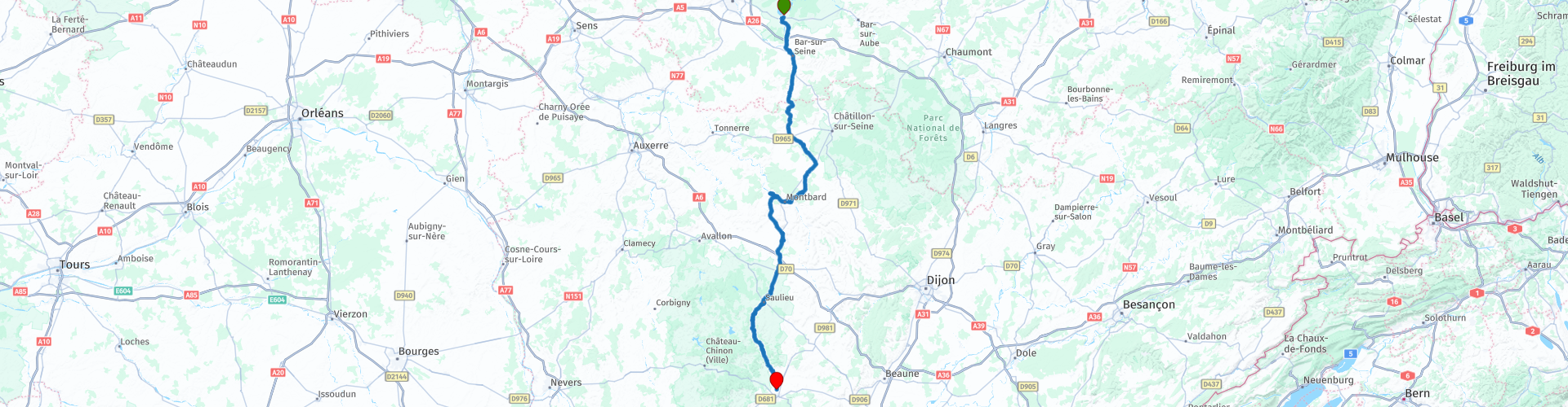
The original starting point is the town of Bar-sur-Seine, but we spent the night in Mesnil-Saint-Pere and so we first drive to Bar-du-Seine (RP2) to reach Polisy (RP3) via a small stretch of the N71. where we pick up the route on the D roads again.
We pass several beautiful villages, including Les Riceys (RP4), known for its rosé and the three churches.
Via Laignes we drive on the D21 to Coulmier-le-Sec where we turn again on the D980 to drive to Montbard through the forest “Forêt de Fontenay”. In this forest lies the Abbaye de Fontenay (RP9), this 12th century abbey owes its name to the presence of a fountain (fontaine) and has historical importance because it is a well-preserved Cistercian monastery. These monks felt that manual labor was just as important as prayer, and the church was called the "workshop of prayer." This is a nice place to stop for a photo. Take the exit for the narrow dirt road at RP9.
We continue on to Montbard (RP10), especially famous because it was the home of the Comte de Buffon (1707-1788). This natural scientist and count wrote "Histoire Naturelle" and left the city a beautiful park at the Museum. If you want to visit this, it's best to park at RP 10 and walk through the town to the park.
About 6 kilometers north-west of Montbard on the D905 is the impressive ironwork "Grande Forge de Buffon" (RP11) that De Buffon founded and which he personally dealt with. Well worth a visit.
The next stop is in Semur-en-Auxois (RP13), a beautiful medieval town with red roofs built on a pink granite plain, in the department of Côte-d'Or, between Montbard and Saulieu, in the middle of a bend of the river Armançon . The city has a rich heritage from its rich history, and a protected area where you can walk. On your own or with a guide, on board a tourist train or with an audio tour, the historic center of Saumur-en-Auxois welcomes you for a journey through time. Go through one of its fortified gates that once protected the town, and head out through the atmospheric streets and pretty squares with city palaces and half-timbered houses. Just park the motorcycle and wander around here is definitely not a bad plan.
On the way to Saulieu we drive into the Morvan area. This region is located in the middle of Burgundy and is formed by a granite massif. It is seen by many as the most beautiful part of Burgundy. What is certain, it is full of pretty little roads, it is very green and there is water everywhere. This route is described in other routes from this series. Saulieu (RP16) is a gastronomic center and therefore a perfect city to pause for a bite to eat.
From Saulieu to the end point Autun is a good 40 kilometers, if you have enough time, drive on the D26. If you have less time, you can also take the D980. In both cases you drive through a beautiful green landscape, but the D26 is slightly nicer, so here is the D26 described; this leads along the Chamboux reservoir (RP20). After the lake the road is called D121. After Alligny-en-Morvan turn left and via the D20 we connect again to the D980.
And then Autun, the end point of this ride. This was chosen because it is conveniently located in a beautiful route to the south, but also because from here Burgundy can be explored well. Autun itself is a beautiful old place with a lot of history.
I appreciate this route with 4 **** stars because of the beautiful roads through the green French landscape, the picturesque villages, towns and sights along the way.


 Links
Links  Usage
Usage Want to download this route?
You can download the route for free without MyRoute-app account. To do so, open the route and click 'save as'. Want to edit this route?
No problem, start by opening the route. Follow the tutorial and create your personal MyRoute-app account. After registration, your trial starts automatically.  Disclaimer
Use of this GPS route is at your own expense and risk. The route has been carefully composed and checked by a MyRoute-app accredited RouteXpert for use on TomTom, Garmin and MyRoute-app Navigation.
Changes may nevertheless have occurred due to changed circumstances, road diversions or seasonal closures. We therefore recommend checking each route before use.
Preferably use the route track in your navigation system. More information about the use of MyRoute-app can be found on the website under 'Community' or 'Academy'.

Grand Est
About this region
Grand Est (French: [ɡʁɑ̃t‿ɛst] (listen); Alsatian: Grossa Oschta; Moselle Franconian/Luxembourgish: Grouss Osten;
Rhine Franconian: Groß Oschte; German: Großer Osten [ˈɡʁoːsɐ ˈʔɔstn̩]; English: "Greater East") is an administrative region in Northeastern France. It superseded three former administrative regions, Alsace, Champagne-Ardenne and Lorraine, on 1 January 2016 under the provisional name of Alsace-Champagne-Ardenne-Lorraine (pronounced [alzas ʃɑ̃paɲ aʁdɛn lɔʁɛn]; ACAL or, less commonly, ALCA), as a result of territorial reform which had been passed by the French Parliament in 2014.The region sits astride three water basins (Seine, Meuse and Rhine), spanning an area of 57,433 km2 (22,175 sq mi), the fifth largest in France; it includes two mountain ranges (Vosges and Ardennes). It shares borders with Belgium, Luxembourg, Germany and Switzerland. As of 2017, it had a population of 5,549,586 inhabitants. The prefecture and largest city, by far, is Strasbourg.
The East of France has a rich and diverse culture, being situated at a crossroads between the Latin and Germanic worlds. This history is reflected in the variety of languages spoken there (Alsatian, Champenois, and Lorraine Franconian). Most of today's Grand Est region was considered "Eastern" as early as the 8th century, when it constituted the southern part of the Francian territory of Austrasia. The city of Reims (in Champagne), where Frankish king Clovis I had been baptized in 496 AD, would later play a prominent ceremonial role in French monarchical history as the traditional site of the coronation of the kings of France. The Champagne fairs played a significant role in the economy of medieval Europe as well. Alsace and Lorraine thrived in the sphere of influence of the Holy Roman Empire for most of the Middle Ages and Renaissance, and subject to competing claims by France and German over the centuries.
The region has distinctive traditions such as the celebration of Saint Nicholas Day, Christmas markets, or traditions involving the Easter hare in Alsace and Lorraine. Alsace-Moselle are furthermore subject to local law for historical reasons. With a long industrial history and strong agriculture and tourism (arts, gastronomy, sightseeing), the East of France is one of the top economic producing regions in the country.
Read more on Wikipedia
Rhine Franconian: Groß Oschte; German: Großer Osten [ˈɡʁoːsɐ ˈʔɔstn̩]; English: "Greater East") is an administrative region in Northeastern France. It superseded three former administrative regions, Alsace, Champagne-Ardenne and Lorraine, on 1 January 2016 under the provisional name of Alsace-Champagne-Ardenne-Lorraine (pronounced [alzas ʃɑ̃paɲ aʁdɛn lɔʁɛn]; ACAL or, less commonly, ALCA), as a result of territorial reform which had been passed by the French Parliament in 2014.The region sits astride three water basins (Seine, Meuse and Rhine), spanning an area of 57,433 km2 (22,175 sq mi), the fifth largest in France; it includes two mountain ranges (Vosges and Ardennes). It shares borders with Belgium, Luxembourg, Germany and Switzerland. As of 2017, it had a population of 5,549,586 inhabitants. The prefecture and largest city, by far, is Strasbourg.
The East of France has a rich and diverse culture, being situated at a crossroads between the Latin and Germanic worlds. This history is reflected in the variety of languages spoken there (Alsatian, Champenois, and Lorraine Franconian). Most of today's Grand Est region was considered "Eastern" as early as the 8th century, when it constituted the southern part of the Francian territory of Austrasia. The city of Reims (in Champagne), where Frankish king Clovis I had been baptized in 496 AD, would later play a prominent ceremonial role in French monarchical history as the traditional site of the coronation of the kings of France. The Champagne fairs played a significant role in the economy of medieval Europe as well. Alsace and Lorraine thrived in the sphere of influence of the Holy Roman Empire for most of the Middle Ages and Renaissance, and subject to competing claims by France and German over the centuries.
The region has distinctive traditions such as the celebration of Saint Nicholas Day, Christmas markets, or traditions involving the Easter hare in Alsace and Lorraine. Alsace-Moselle are furthermore subject to local law for historical reasons. With a long industrial history and strong agriculture and tourism (arts, gastronomy, sightseeing), the East of France is one of the top economic producing regions in the country.
View region
 Statistics
  75
75Amount of RX reviews (Grand Est)
 33736
33736Amount of visitors (Grand Est)
 11186
11186Amount of downloads (Grand Est)
 Route Collections in this region
 25 Magnificent trails in France
This MRA route collection contains 25 beautiful motorcycle routes in different parts of France, such as the Ardennes, the Alsace, Vercors, the Drôme, the Ardèche, Cote d'Azure, Gorges du Verdon, the Ariège, the Dordogne and Brittany.
The routes have been carefully created by Bert Loorbach, who is an enthusiastic motorcyclist himself. He lived in France for a year and a half, during which time he devoted himself to mapping the unknown and beautiful back roads of France especially for motorcyclists.
The routes are bundled in the Motortourgids France part 1 of Kosmos publishing house and now also available in MyRouteApp.
I have taken over the routes in MRA and sometimes adjusted them slightly to make them even more interesting for the motorcyclist.
View Route Collection
11 day trip from the Netherlands
8 countries in 11 days; The Netherlands, Germany, Austria, Italy, Switzerland, France, Luxembourg and Belgium. This route collections consists of 10 routes that I have driven with friends in the summer of 2019.
The start is in Geldermalsen Netherlands, the first 7 days you drive through the Netherlands, Germany, Austria, Italy, Switzerland, France and a piece of Luxembourg with overnight stays in hotels.
The last three days you stay in Barweiler (D) in the Eifel and you drive two beautiful tours through the Eifel, Luxembourg and parts of the Belgian Ardennes.
There is no highway in the routes, only beautiful provincial and country roads, many beautiful passes with beautiful panoramas.
Be sure to check whether the passes are open before you leave.
These are routes for experienced drivers.
View Route Collection