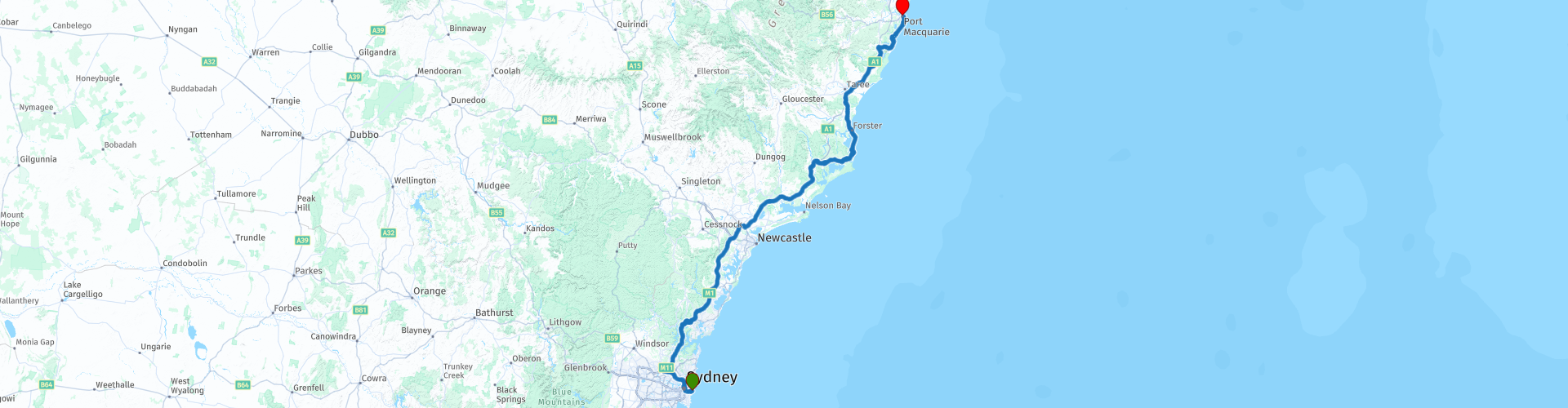
R07 NSW Sydney to Port Macquarie

This route was brought to you by:
RouteXpert Hans van de Ven (Mr.MRA)
Last edit: 07-03-2020
 Route Summary
 Australia is very big; 8 million km2, that is more than 226 times larger than the Netherlands! Has a diversity of flora and fauna; the most diverse types of plants, trees and animals, especially birds and a lot of typical Australian marsupials, that you won't find anywhere else in the world!
Enormous enjoyment of all the beautiful things: From the evergreen tropical rain forests to the vast Outback; from the desert to the countless and tranquil idyllic palm beaches; from the winter sports areas in the southeast to the bustling and impressive millions of cities of Melbourne, Sydney and Perth.
You will see it all and experience it in this great tour through Australia, a tour you will never forget!
Starting point: Sydney, Hotel Bondi
End point: Port Macquarie, Hotel Waters Edge
The route has been made the same for TomTom, Garmin and MyRoute-app Navigation users.
ATTENTION: LEFT DRIVING!
 Share this route


Animation

Verdict


Duration
5h 51m

Mode of travel
Car or motorcycle

Distance
434.72 km

Countries

 RouteXpert Review
 You leave Sydney via the Pacific Motorway Sydney - Newcastle, this M1 Pacific Motorway, also known by the former names F3 Freeway, Sydney - Newcastle Freeway and Sydney - Newcastle Expressway; is a 127 km highway that connects Sydney with the Central Coast, Newcastle and Hunter regions of New South Wales. It is part of the AusLink pathway between Sydney and Brisbane. After an hour it is time to visit the Old Pacific Highway, this is a nice curvy part of a small 20 Km through Mooney Mooney Creek. Mooney Mooney Creek is a suburb of the Central Coast region of New South Wales, 60 kilometers north of Sydney along both sides of the river it is named after. It is part of the local government area of the Central Coast Council. Then you take the Pacific Motorway again up to Newcastle. Newcastle, an industrial town 167 km north of Sydney at the mouth of the Hunter River. The city had 288,732 inhabitants in the 2006 census, making it the 8th city in the country. You do not enter Newcastle, but you go onto the Pacific Highway, to leave it again after 4 KM, because in the Hunter Region Botanic Gardens, a coffee / lunch stop is planned and you can also take some nice pictures in the garden . The award-winning Hunter Region Botanic Gardens is managed and maintained by volunteers, and is used, among other things, for the enjoyment and education of people in the Hunter region and visitors from Australia and abroad. Then again a small 80 KM Pacific Highway to drive along the Lakes Way along the Myall Lakes, these are a series of freshwater lakes protected by the Ramsar convention. These are located in the Mid-Coast Council local government area in the Mid North Coast region of New South Wales. The Myall lakes border the east coast, about 250 kilometers north of Sydney.
After about 160 km you leave the Lakes Way and turn onto the Pacific Highway again. At Kew, you leave the Pacific Highway, it is then just under 50 KM to the end point in Port Macquarie, where you can relive this more or less Highway route in the hotel's swimming pool.
This 4-star rated route is mainly about beautiful highways, with occasional trips through nature reserves and a few small towns where you can stop for a snack.
General info:
New South Wales is a state of Australia with Sydney as its capital, and is often abbreviated to NSW. The three most important cities are, from north to south, Newcastle, Sydney and Wollongong, which are all on the coast. Other cities are Albury, Broken Hill, Dubbo, Tamworth, Armidale, Lismore, Nowra and Coffs Harbor.
The state is located on the east coast of the continent, north of the state of Victoria and south of the state of Queensland. In the west it borders South Australia. The coast borders the Tasman Sea. New South Wales has two federal enclaves: the Australian Capital Territory (ACT) and the Jervis Bay Territory.
New South Wales can be physically divided into four parts:
A narrow coastal strip, with a climate whose temperature varies from temperate on the extreme south coast to subtropical on the Queensland border.
The mountainous areas of the Greater Australian Separation Mountains and the highlands that surround it, such as the Southern Highlands, Central Tablelands and the regions of New England. Even though the mountain walls are not very steep, many mountain tops exceed 1000 meters, of which Mount Kosciuszko reaches 2229 meters as the highest peak.
The agricultural plains, which make up a large part of the area of the state. These areas are much less densely populated than the coast. This part includes the Riverina region.
The dry, desert-like plains in the far north-west of the state, which are unsuitable for settlements of any size.
It is the oldest colony of the former Australian colonies of the United Kingdom. The colony was founded in 1788 and originally included much more of the Australian mainland. At that time, the western half of the colony was called New Holland and the eastern half was New South Wales. New Holland was controlled from Sydney.
During the nineteenth century large areas were separated around the British colonies Van Diemen's Land (Tasmania) (1825), Victoria (1851), Queensland (1859) and South Australia (1836) (which at that time also included the Northern Territory) to shape. These colonies and Western Australia voted in 1901 to continue together as the Commonwealth of Australia.
Tourist attractions in the state include; The Blue Mountains, west of Sydney, a national park including the Three Sisters rock formation; The Hunter Valley, 150 km north of Sydney, the oldest wine region in Australia. The Snowy Mountains, on the border with Victoria, a popular ski resort, and the capital, Sydney.


 Links
Links  Usage
Usage Want to download this route?
You can download the route for free without MyRoute-app account. To do so, open the route and click 'save as'. Want to edit this route?
No problem, start by opening the route. Follow the tutorial and create your personal MyRoute-app account. After registration, your trial starts automatically.  Disclaimer
Use of this GPS route is at your own expense and risk. The route has been carefully composed and checked by a MyRoute-app accredited RouteXpert for use on TomTom, Garmin and MyRoute-app Navigation.
Changes may nevertheless have occurred due to changed circumstances, road diversions or seasonal closures. We therefore recommend checking each route before use.
Preferably use the route track in your navigation system. More information about the use of MyRoute-app can be found on the website under 'Community' or 'Academy'.

New South Wales
About this region
New South Wales (abbreviated as NSW) is a state on the east coast of Australia. It borders three other states, Queensland to the north, Victoria to the south, and South Australia to the west. Its coast borders the Coral and Tasman Seas to the east. The Australian Capital Territory is an enclave within the state. New South Wales' state capital is Sydney, which is also Australia's most populous city. In June 2020, the population of New South Wales was over 8.1 million, making it Australia's most populous state. Just under two-thirds of the state's population, 5.3 million, live in the Greater Sydney area. The demonym for inhabitants of New South Wales is New South Welshmen.The Colony of New South Wales was founded as a British penal colony in 1788. It originally comprised more than half of the Australian mainland with its western boundary set at 129th meridian east in 1825. The colony then also included the island territories of Van Diemen's Land, Lord Howe Island, and Norfolk Island. During the 19th century, most of the colony's area was detached to form separate British colonies that eventually became the various states and territories of Australia. However, the Swan River Colony was never administered as part of New South Wales.
Lord Howe Island remains part of New South Wales, while Norfolk Island has become a federal territory, as have the areas now known as the Australian Capital Territory and the Jervis Bay Territory.
Read more on Wikipedia
Lord Howe Island remains part of New South Wales, while Norfolk Island has become a federal territory, as have the areas now known as the Australian Capital Territory and the Jervis Bay Territory.
View region
 Statistics
  8
8Amount of RX reviews (New South Wales)
 12225
12225Amount of visitors (New South Wales)
 475
475Amount of downloads (New South Wales)
 Route Collections in this region
 Top Car and Motorcycle Route from Melbourne to Brisbane
Planning to go through Australia by motorcycle? Then read the five tips below carefully, so that you can start your motorcycle holiday well prepared. Good preparation is half the job.
1. Decide in advance where you want to rent your motorcycle. Find a reliable rental company with good reviews. By comparing the prices of various rental companies, you can save a lot of money.
2. Plan your routes in advance. Australia is so big that it is useful to know in advance exactly where you want to go.
3. In Australia you don't just get from A to B: you have to drive a long time to get to your next destination. Practicing long motorcycle riding is therefore definitely recommended.
4. Always check the weather forecast. You can't take much on the bike, so only bring what you really need according to the weather forecast.
5. Are you going in high season? Book your accommodations in advance. If you plan to go camping, invest in a good tent.
Motorbike rental:
AussieRider : https://www.aussierider.com/bikes/australie/#
EagleRider : https://www.eaglerider.com/motorverhuur/australia
General:
Toll roads:
Toll roads are ideal for getting around or through a huge city like Sydney, Melbourne or Brisbane quickly and very easy to use. There are no toll booths, so it is not possible to pay on site. The toll must be paid by yourself by telephone and credit card within three days after using the road or tunnel. When you pick up the rental motorcycle, you will receive all the information about this. It's a simple system but it requires action from yourself to avoid fines.
Motorbike traffic rules:
Motorcycling rules in Australia vary by state or territory. Inquire about the regulations on site.
Helmet:
Wearing a helmet is mandatory for driver and passenger. The helmet must comply with the Australian Standard (AS/NZS1698) or the European Standard (UNECE 22.05), which is indicated on a decal or label inside the helmet. In some states, such as New South Wales and Victoria, a helmet may no longer meet the standard if a small camera is mounted on it, if speakers (Bluetooth) are built in, or if the helmet has a tinted visor.
Lighting: Dipped beam is not mandatory during the day, but is recommended.
Passengers:
The carriage of 1 passenger is allowed. Children under 8 years of age are not allowed to be transported on the motorbike. Children from 8 years old may only be transported on the back if they can reach the footrests with their feet. Younger children may be transported in a sidecar. In several states, such as New South Wales, Northern Territory and Queensland, it is only allowed to carry a passenger if the driver has held a motorcycle license for more than one year.
Driving side by side:
Two motorcycles may ride side by side, provided that their mutual distance does not exceed 1.5 m.
traffic jams:
In Australia it is allowed to slalom between stationary or slow-moving cars in a traffic jam (lane filtering) provided a maximum speed of 30 km/h is maintained and other traffic is not endangered.
gas stations:
In Australia, a gas station is often referred to as servo (derived from service station). In the outback, a gas station is often called a road house. Pay attention; The number of filling stations is very limited, especially along the southern main route and the north-south connections. Keep this in mind and take enough spare fuel with you. For example, use the Fuel Map Australia app (fuelmap.com.au) to search for nearby gas stations and see current fuel prices.
Opening hours:
Gas stations are usually open at least from 8 a.m. to 6 p.m. or 8 p.m. Many gas stations in larger towns and along highways offer 24-hour service or have gas dispensers. When planning longer trips, keep in mind that outside the major towns and along minor roads, gas stations are not open at night or in the morning, and sometimes on Sundays.
Pay:
Cash can be paid at petrol stations. Credit cards are accepted at most gas stations.
Tank machines:
Major credit cards are usually accepted at fuel dispensers (pay-at-the-pump), but often require a PIN to be used.
Reserve fuel:
Because the distances between places in Australia are long and gas stations in the outback may not always have sufficient fuel in stock, it is recommended that you always carry a spare tank of fuel. It is prohibited to carry fuel in a reserve tank on ferries.
View Route Collection
The 10 most downloaded routes in Australia from RouteXpert Hans van de Ven
Hello and welcome to this collection of the Top 10 MyRoute app downloaded routes in Australia.
There will be a great new event to be announced soon, where all these routes can be driven.
Download them all now and place them in a new "Top 10" folder, so that you always have them at hand.
If you are going to drive one of these routes in the meantime, track them with the MRA Mobile App or with MRA Navigation. Take some photos (moments) along the way as these will come in handy.
Create a travelogue of your Top 10 driven routes and add the recorded track to it.
There will also be some great prizes on offer, so keep an eye on the MRA-RouteXperts page and your mail.
The 10 routes are:
1. R06 NSW Jenolan to Sydney
2. R04 NSW Jenolan Roundtrip Blue Mountains North West
3. R02 VIC NSW Wangaratta to Canberra
4. R05 NSW Jenolan Roundtrip Blue Mountains East
5. R23 NT Darwin to Willeroo
6. R54 Williamstown to Melbourne
7. R47 SA Roundtrip Adelaide South
8. R35 WA Perth to Mount Barker
9. R19 NT Tennant Creek to Mataranka
10. R10 QLD Chinchilla to Springsure
View Route Collection