Day 33 TCH Clarenville to St John

This route was brought to you by:
RouteXpert René Plücken (MRA Master)
Last edit: 12-02-2021
 Route Summary
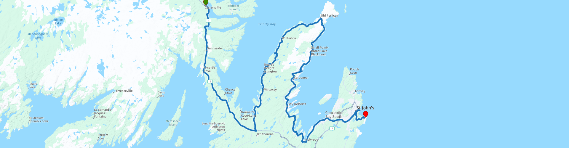
 This is the last section that runs from Clarenville to the Easternmost point of Canada in St John.
The Trans Canada Highway passes through all the southern provinces of the country. The route can be driven in different ways. There are namely in various alternative routes that also belong to the TCH. The total distance is around 8,000 km. We not only drive the TCH, but will take the rural roads as much as possible, because only highway driving is too boring and Canada has many beautiful roads through its beautiful landscape.
You drive through all provinces and through very varied and scenic landscapes, from the Rockies in the West, the Central Prairies to the Eastern Maritimes and the Northern Forest.
The riding season is generally April through October with longer seasons on the west coast and southern Ontario.
Provide good all season clothing or bring rain gear, depending on the province and the season the weather can change and you may be surprised by a rain or even a snow or hail shower, so be prepared.
In Canada the metric system is used, so speeds are indicated in Km / h. A helmet requirement (DOT approved) applies throughout Canada.
You will see many wildlife throughout Canada. your similar animals from province to province, such as deer, buffalos, moose, caribou, wolves, pumas, bears, mountain goats, sheep, lynx, coyotes, foxes, raccoons, badgers, various rodents and all kinds of birds.
Even if it is very tempting to stop for a photo, don't do it, it can be very dangerous.
 Share this route


Animation

Verdict


Duration
7h 29m

Mode of travel
Car or motorcycle

Distance
395.93 km

Countries

 RouteXpert Review
 The original route from Clarenville to St. John on the Trans Canada Highway is approximately 200 kilometers and a 2½ hour drive, so if you are in a hurry follow the NL-1 from Clarenville, not a bad road to drive but you will miss a lot of beautiful things we will see in the route of almost 400 kilometers described here.
We drive just above Whitbourne on the Trans Canada Highway, the road leads through a beautiful, green and hilly to mountainous area. On the way you can enjoy all this beauty, you cross a few rivers and drive along small lakes (ponds). Whenever possible, stop to enjoy and take photos.
Just above Whitbourne, we turn left at Cross Roads to continue on NL-80 Trinity Road, which winds north along the banks of Trinity Bay, which are all small bays. Along the way you can enjoy the truly beautiful panoramas, there are several beautiful points to stop for a short photo. Along the way you can also visit several nice sights such as;
RP6 the Dildo Brewing Co. & Museum, The Dildo Outport Heritage Museum is located in the brewery, full of Newfoundland history and culture at its best. Discover the rich and diverse history of Dildo, Newfoundland. The museum is operated 12 weeks a year during the summer months and is managed by local students. A nice little beer brewery and definitely worth a stop.
At RP9 you can stop for a photo and possibly a hike on the Jimmy's Ponds Walking Trail. A beautiful mountain lake that you can walk around, the entire trail is about 9.5 kilometers.
Another interesting stop is the Heart's Content Cable Station (RP16), a former cable telegraph station. It served as the western terminus of the first permanent trans-oceanic submarine telegraph cable, while a sister cable station on Valentia Island, Ireland, served as the eastern terminus. The original cable was first brought ashore in Heart's Content on July 27, 1866, and the station remained in use until it closed in 1965. The station was designated a Provincial Historic Site in 1974 and is now a museum. On December 20, 2017, it was announced that the Heart's Content Cable Station would be one of eight new sites nominated by the Canadian government for UNESCO World Heritage status.
The next stop is at the Wooden Boat Museum of Newfoundland and Labrador (RP17), discover here the cultural emblems that have contributed to Newfoundland and Labrador history. Every wooden boat provides a snapshot of life in this province. Exhibits contain personal experiences of the residents and their connection to the sea through the ships they built. Listen to the stories and get a fascinating glimpse into this indelible tradition. Visit the boat shed and see the boat builder in action or help build a piece of history by participating in one of the boat building workshops.
We drive to the town of Old Perlican, this is almost the extreme point of this headland. We stop here for lunch at Jungle Jim's Eatery (RP23). A franchise casual restaurant and bar with 26 locations across Canada. Enjoy great food such as burgers, pasta, wings and more!
Those who want to go even further north can continue on Trinity Road to Grates Cove. After lunch we take the Main Highway NL-70 back to the south. This road winds along the coast of Conception Bay and guarantees beautiful panoramas and wonderfully winding roads.
We drive through small fishing villages and along beaches where you can take a refreshing dip. Such as at Northern Bay Sands Park and beach (RP26), a beautiful large sandy beach where there is also a small waterfall that flows into the bay.
Another point where you should definitely stop is RP29 Salmon Cove Sands, at this beach is a beautiful rock formation that runs into the sea. Definitely worth taking a photo. In Carbonear (RP31) you can stop for a drink or something to eat, here are several restaurants and snack bars.
After this short stop we take the Conception Bay Highway with truly beautiful panoramas of the Conception Bay, mountains and smaller bays. At RP38 we stop briefly to take a picture of the shipwreck of the SS Charcot, a ship built for whale hunting in the North Atlantic. The steel ship was built in Tonsberg, Norway in 1923. In 1943 it was sold to the Polar Whaling Company, which was based in southern Labrador. It was then sold to the Hawkes Harbor Whaling Company, which was based in Conception Bay.
The ship had a length of 117 ft, a beam / width of 21.6 ft and weighed 212 tons. It was one of the five whalers owned by Captain Johan Borgen of the Hawke Harbor Whaling Company. In 1970, the ship broke from her berth during a storm and was pushed ashore. Today, the ship's rusted hull peaks through the water and on a beach at Conception Harbor, 2.5 miles north of Avondale. For years, locals believed that this ship was another whaler called SS Sposa. However, when the "Shipwreck Preservation Society of NL" investigated the ship underwater, they discovered it was the SS Charcot.
While inspecting the ship, they discovered that two more whalers had sunk on the seabed behind the Charcot. After finding measurements of the sunken ships, they concluded that the two ships were the whalers, the SS Southern Foam and the SS Sukha.
Today, together with the hull of the ship, many old mechanical parts lie on the beach. The ships are located in Conception Harbor and can be seen while driving on the CBS Highway (Route 60). There is a small parking lot and a picnic area next to the ship's hull.
We continue around the bay on the NL-60 and from Holyrood we arrive again in a densely inhabited area with small towns, in Manuel's River we stop at RP41 to take a picture of the truly spectacular Little Canyon. A beautiful rugged rock formation in the river with all small waterfalls. You can also hike on the Little Canyon Trail here.
After this stop it is time to start the last part of the route, for this we turn onto the Peacekeeper Highway to St. John, before we drive to the end point we stop at RP42 to take a picture of the beautiful view at the lighthouse “Fort Amherst Lighthouse”. Then we drive the last kilometers to the most South Eastern point of Canada / North America. With this we have come to the end of this great road-trip and this last stage is rightly worthy of a worthy conclusion with 5 Gold Stars.


 Links
Links  Usage
Usage Want to download this route?
You can download the route for free without MyRoute-app account. To do so, open the route and click 'save as'. Want to edit this route?
No problem, start by opening the route. Follow the tutorial and create your personal MyRoute-app account. After registration, your trial starts automatically.  Disclaimer
Use of this GPS route is at your own expense and risk. The route has been carefully composed and checked by a MyRoute-app accredited RouteXpert for use on TomTom, Garmin and MyRoute-app Navigation.
Changes may nevertheless have occurred due to changed circumstances, road diversions or seasonal closures. We therefore recommend checking each route before use.
Preferably use the route track in your navigation system. More information about the use of MyRoute-app can be found on the website under 'Community' or 'Academy'.

Newfoundland and Labrador
About this region
Newfoundland and Labrador (; sometimes abbreviated as NL) is the easternmost province of Canada, in the country's Atlantic region. It is composed of the island of Newfoundland and the continental region of Labrador to the northwest, with a combined area of 405,212 square kilometres (156,500 sq mi). In 2018, the province's population was estimated at 525,073. About 94% of the province's population lives on the island of Newfoundland (and its neighbouring smaller islands), of whom more than half live on the Avalon Peninsula.
The province is Canada's most linguistically homogeneous, with 97.0% of residents reporting English (Newfoundland English) as their mother tongue in the 2016 census. Historically, Newfoundland was also home to unique varieties of French and Irish, as well as the extinct Beothuk language. In Labrador, the indigenous languages Innu-aimun and Inuktitut are also spoken.
Newfoundland and Labrador's capital and largest city, St. John's, is Canada's 20th-largest census metropolitan area and is home to almost 40 per cent of the province's population. St. John's is the seat of government, home to the House of Assembly of Newfoundland and Labrador and to the highest court in the jurisdiction, the Newfoundland and Labrador Court of Appeal.
Formerly a colony and then a dominion of the United Kingdom, Newfoundland gave up its independence in 1933, following significant economic distress caused by the Great Depression and the aftermath of Newfoundland's participation in World War I. It became the tenth and final province to enter Confederation on March 31, 1949, as "Newfoundland". On December 6, 2001, an amendment was made to the Constitution of Canada to change the province's name to Newfoundland and Labrador.
Read more on Wikipedia
The province is Canada's most linguistically homogeneous, with 97.0% of residents reporting English (Newfoundland English) as their mother tongue in the 2016 census. Historically, Newfoundland was also home to unique varieties of French and Irish, as well as the extinct Beothuk language. In Labrador, the indigenous languages Innu-aimun and Inuktitut are also spoken.
Newfoundland and Labrador's capital and largest city, St. John's, is Canada's 20th-largest census metropolitan area and is home to almost 40 per cent of the province's population. St. John's is the seat of government, home to the House of Assembly of Newfoundland and Labrador and to the highest court in the jurisdiction, the Newfoundland and Labrador Court of Appeal.
Formerly a colony and then a dominion of the United Kingdom, Newfoundland gave up its independence in 1933, following significant economic distress caused by the Great Depression and the aftermath of Newfoundland's participation in World War I. It became the tenth and final province to enter Confederation on March 31, 1949, as "Newfoundland". On December 6, 2001, an amendment was made to the Constitution of Canada to change the province's name to Newfoundland and Labrador.
View region
 Statistics
  4
4Amount of RX reviews (Newfoundland and Labrador)
 8714
8714Amount of visitors (Newfoundland and Labrador)
 142
142Amount of downloads (Newfoundland and Labrador)
 Route Collections in this region
 Trans Canada Highway
The Trans-Canada Highway (TCH) or Trans-Canadian Highway is a system of highways that cover all 10 provinces of Canada.
The Federal and Provincial Highways System that now forms the TCH were authorized by the Trans-Canada Highway Act of 1948 and opened in 1962. It was completed in 1971. The total length of the TCH is 7821 km.
Contrary to the American Interstate Highway System, the TCH does not consist of an unambiguous network of motorways, but forms a network of restricted access highways and other main routes that are more akin to the Dutch provincial roads. The route is indicated by a green shield with a white maple leaf.
The numbering of the roads that are part of the TCH is the domain of the provinces. Only the western provinces have aligned their numbering and the TCH has the designation Highway 1 there.
The main route of the TCH starts in Victoria in British Columbia and runs via Calgary and Regina to Winnipeg. From Winnipeg the route leads to Kenora in Ontario, after which several branches pass through Ontario to Ottawa.
Further east, the route passes through the province of Quebec via Montreal and Quebec, among others, to Moncton, New Brunswick. Then the TCH continues east through Nova Scotia, where a branch (via the Confederation Bridge) leads to Prince Edward Island. Another section runs down to the sea in the port city of Sydney, where a ferry service leaves for Channel-Port aux Basques on the island of Newfoundland. From there the route continues for more than 900 km to the provincial capital of St. John's, in the extreme southeast of the island.
We not only drive the TCH, but will take the rural roads as much as possible, because only Highway driving is too boring and Canada has many beautiful roads through its beautiful landscape. You drive through all provinces and through very varied and scenic landscapes, from the Rockies in the West, the Central Prairies to the Eastern Maritimes and the Northern Forest.
The riding season is generally April through October with longer seasons on the west coast and southern Ontario. Provide good all season clothing or bring rain gear, depending on the province and the season the weather can change and you may be surprised by a rain or even a snow or hail shower, so be prepared.
In Canada the metric system is used, so speeds are indicated in Km / h. A helmet requirement (DOT approved) applies throughout Canada.
You will see many wildlife throughout Canada. This varies from province to province, such as deer, buffalos, moose, caribou, wolves, pumas, bears, mountain goats, sheep, lynx, coyotes, foxes, raccoons, badgers, various rodents and all kinds of birds. Even if it is very tempting to stop for a photo, don't do it, it can be very dangerous.
The routes described in this review sometimes deviate from the Trans Canada Highway, bringing the total length to 9,300 kilometers. The routes are made so that you drive through the beautiful parts of Canada with truly beautiful panoramas and beautiful sights to visit, this differs from museums, parks to historical points. The routes are not too long so there is time to stop for photos and sights along the way. You can also choose to arrange and combine the stages differently or to add other routes to shorten or extend your journey. The routes are marked with a rating in stars, some routes are less challenging or interesting but are necessary to drive to the next point, which is why they often have a lower rating.
In the route description you will find more details about the routes and the points of interest along the way. These points and also hotels, restaurants, petrol stations etc. are indicated with a POI and sometimes also with a Route point. In the description you will also find links to interesting sites and to the routes that connect to that day.
The described routes are;
Day 01 TCH Victory to Nanaimo
Day 02 TCH Nanaimo to Hope
Day 03 TCH Hope to Kamloops
Day 04 TCH Kamloops to Revelstoke
Day 05 TCH Revelstoke to Lake Louise
Day 06 TCH Lake Louise to Calgary
Day 07 TCH Calgary to Medicine Hat
Day 08 TCH Medicine Hat to Moose Jaw
Day 09 TCH Moose Jaw to Regina
Day 10 TCH Regina to Brandon
Day 11 TCH Brandon to Winnipeg
Day 12 TCH Winnipeg to Kenora
Day 13 TCH Kenora to Ignace
Day 14 TCH Ignace to Thunder Bay
Day 15 TCH Thunder Bay to Marathon
Day 16 Thunder Bay to Wawa
Day 17 TCH Wawa to Sault Ste Marie
Day 18 TCH Sault Ste Marie to Espanola
Day 19 TCH Espanola to Mattawa
Day 20 TCH Mattawa to Ottawa
Day 21 TCH Ottawa to Montreal
Day 22 TCH Montreal to Quebec
Day 23 TCH Quebec to Riviere du Loup
Day 24 TCH Riviere du Loup to Grand Falls
Day 25 TCH Grand Falls to Fredericton
Day 26 TCH Fredericton to Moncton
Day 27 TCH Moncton to Charlottetown
Day 28 TCH Charlottetown to Truro
Day 29 TCH Truro to North Sydney
Day 30 TCH North Sydney to Corner Brook
Day 31 TCH Corner Brook to Grand Falls
Day 32 TCH Grand Falls to Clarenville
Day 33 TCH Clarenville to St John.
Have fun reading the reviews and planning your next road trip.
If you have driven this trip, I am very curious about your feedback!
View Route Collection