13 From Logarska Dolina to Sachsenburg via several Panoramaroads

This route was brought to you by:
RouteXpert Leonor Orban - Sr. RouteXpert
Last edit: 06-12-2020
 Route Summary
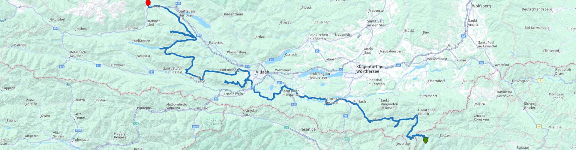
 The climb over the first mountain pass begins immediately upon leaving Logarska Dolina. This only stops at the very last moment, at the access route to the hotel in Sachsenburg. Along the way you will drive over mountain passes and panorama streets such as the Trögerner Klamm, Schaidasattel, Villacher Alpenstrasse and the Goldeck Panoramastrasse.
This 13th stage of a tour through Eastern Europe is a wonderful touring pleasure. One bend after another sends you further and further into Austria. You will see beautiful views along the way. Kaernten is undeniably a wonderful place to tour.
 Share this route


Animation

Verdict


Duration
6h 46m

Mode of travel
Car or motorcycle

Distance
275.02 km

Countries


 RouteXpert Review
 If I had to give today's route a title, I would call it the turn-around route. You will regularly have to turn around, because you have reached the end of a dead end ... And no, the waypoints are not wrong.
The route from Logarska Dolina to Sachsenburg passes through Kärnten. This is one of the 9 Bundesländer (provinces) in Austria and is considered one of the most beautiful provinces in the country due to the varied landscape. For motorcyclists this means that riding through rolling valleys and gorges is alternated with spectacular climbs over dead ends, among other things. A more appropriate title for such a dead end road is Panorama Street: from the valley you climb higher and higher. Along the way you regularly have the opportunity to enjoy the many views. The icing on the cake is a delicious break at a mountain restaurant with spectacular views (often 360 degrees).
Today we leave Slovenia behind. Weather permitting, you will have breakfast with a view this morning. On some days the clouds hang high in the Logar valley, giving you a good impression of the beautiful surroundings. One last time you drive through the valley towards the exit and you are waved goodbye by the golden brown colored Longhorns.
There is no time to wake up peacefully. Immediately after leaving the valley you will be put to work. The Paulitschsattel immediately demands all your attention. Tight turns are followed by even tighter hairpin turns and finally the border crossing on top of the mountain. Customs are present, so keep in mind that your passport will be checked. You can usually continue with a gentle swing and start the descent to Bad Eisenkappel. Here you can, if necessary, refuel (rp 4) and also take a photo of Hagenegg Castle (rp 3). Little is known about the origin and dating of this castle. There are suspicions that a Roman fort has already stood on this spot to protect an old Roman road. The oldest part of the current castle is said to stand on remains of a structure from 1316. Currently, the castle is owned by a noble family, so it is not open for visitors. From the parking lot you have a view of the part that was built in the 15th and 16th centuries.
You have arrived in Kärnten, Austria, after crossing the border. In Dutch we also call this area Carinthia. This name is not entirely correct, because it refers to a larger area that runs in Slovenia, in addition to Austria, between the Karawanken and the Alpenhauptkamm. When driving up the various panoramic streets you will regularly enjoy the view of both mountain areas.
But first we dive into a Klamm or Schlucht. These are gorges, often caused by erosion by water for centuries. The Trögerner Klamm (your first dead end road today) was created because the Trögernbach found its way through the soft limestone of the area. The result is a wonderful ride through the Trögerner gorge. If you take a good look around you, you will also see different layers of a sea in the rock around you. Because the area in and around the Klamm is a protected nature reserve, you will see a large sign at the entrance of the gorge (rp 5). The local mayor asks you to visit the gorge on foot. It is not a prohibition sign. Feel free to visit the canyon by motorcycle, but do it respectfully. In general, the gorge is quite calm. There are few tourists. Keep in mind that forestry is practiced in this area. It could just be that a large PKW fully loaded with tree trunks comes towards you in a blind corner. You can take a break at the end of the gorge. In the summer months you will find, next to the picnic spot, a cabin (rp 6) where you can buy tasty simple dishes and drinks. Ultimately, there is no other option but to turn around and drive back the same way. Fortunately this is not a punishment!
Via the simple and quiet Schaidasattel (rp 7) you continue the route further to the West. With a maximum height of 1069m, it is not an exciting climb. On the way you may come across signs to enter the Hochobir-Panoramastrasse. I left this panorama street (with toll) out of the route. The way up is quite narrow and unclear, the climax at the top is disappointing. Today you will come across more beautiful panoramic streets ...
But first you discover another characteristic of Kärnten. Many people call this province a wet province. Fortunately, this does not refer to rain showers, but to the large presence of lakes and rivers. You will encounter the first immediately after you have entered a more densely populated area. You cross the Drau river with the Feistritzer on the left and the Ferlacher reservoir on the right (rp 8). Both reservoirs provide a large part of the local population with electricity. If you have trouble navigating today: the Drau river (rp 10) is a good guide. As long as you continue to follow the route westward, you will automatically arrive at the end point in Sachsenburg. You can also follow the river eastwards. You then have a beautiful ride through Slovenia, Croatia and Hungary. Eventually you will arrive at the border with Serbia, where the Drau (or Drava) ends in the Danube. If you have an extra week off, this is a nice extra to hopefully already a successful holiday.
After rp 11 you deviate from the Drau to visit Burgruine Finkenstein (rp 13). This medieval fortress is located on top of a gorge, at the foot of the Karawank Mountains. You can stop here to take pictures and enjoy the view of Lake Faak. You can also take a longer break here at the local restaurant. The route does not include a longer stop here, as the climb on the Villacher Alpenstrasse is slowly becoming visible.
It takes about 20 minutes to arrive at the toll booth (rp 14) for Villacher Alpenstrasse. With the purchased vignette you have access to today's second dead end. The panorama street will lead you to an altitude of approximately 2000m in the Dobratsch nature park. The broad, tightly paved street meanders upwards. Along the way you have several viewpoints, where you have a good view of the Karawank mountains in Slovenia and the mountains in the North. All this hard work should eventually be rewarded: on top of the summit, you can take a break at the Rosstrattenstüberl. This large mountain restaurant naturally has a lovely terrace!
After the break, the big turnaround starts again. If you stopped here and there at the viewpoints on the way up, you can now sail down over the big curves.
The road continues to the Weißensee (rp 19). This is a well-known name for the Dutch. The Elfstedentocht is an important annual event in the Netherlands and is a skating competition of approximately 200 km over natural ice in Friesland. It causes the necessary "Eleven Cities" fever for many skating fans. Do the temperatures drop below freezing for long enough for the rivers to freeze over? 1997 was the last time the race was actually held in Friesland. As an alternative, the alternative Elfstedentocht is held annually on this Weißensee.
You can continue the route by turning around ???? and drive back the same way. In the end you really visit the last dead end of the route: the Goldeck-Panoramastraße. At the toll booth (rp 21) you buy another vignette to be able to drive on the road. A few hairpin bends later you drive via a sloping road to the top at an altitude of approximately 1890m. Here too you can take a break (Gasthof Wieser Hütte) to turn around again and descend the same road.
Once you have left the panorama street you can see the Millstätter See and Spittal an der Drau in the distance, where you can also refuel (rp 26). The river will accompany you towards your end point. At Gasthof Zum Goldenen Rössl, the owner Ferdinand greets you friendly. He shows you where you can safely park your motorcycle (via a narrow passage), and then settle down on the terrace with a delicious cold beer or glass of wine. Enjoy it!
The route gets 5 points from me. It is a wonderful ride through the beautiful nature reserve of Kärnten. The panorama streets are a joy to drive, with the climax always a magnificent view of the surrounding mountains, valleys and lakes. In good Austrian custom, you can take a pleasant break at the mountain restaurants on any mountain peak. With a length of 275 km, the route is easy to drive. If you are at risk of arriving late at your final destination due to the many pauses and enjoying the views, you can easily shorten the route by skipping one of the dead ends.


 Links
Links  Usage
Usage Want to download this route?
You can download the route for free without MyRoute-app account. To do so, open the route and click 'save as'. Want to edit this route?
No problem, start by opening the route. Follow the tutorial and create your personal MyRoute-app account. After registration, your trial starts automatically.  Disclaimer
Use of this GPS route is at your own expense and risk. The route has been carefully composed and checked by a MyRoute-app accredited RouteXpert for use on TomTom, Garmin and MyRoute-app Navigation.
Changes may nevertheless have occurred due to changed circumstances, road diversions or seasonal closures. We therefore recommend checking each route before use.
Preferably use the route track in your navigation system. More information about the use of MyRoute-app can be found on the website under 'Community' or 'Academy'.

Savinjska
About this region
The Savinja Statistical Region (Slovene: Savinjska statistična regija) is a statistical region in Slovenia. The largest town in the region is Celje. It is named after the Savinja River. The region is very diverse in natural geography; it mainly comprises the wooded mountainous terrain attractive to tourists (the Upper Savinja Valley and part of the Kamnik–Savinja Alps), the fertile Lower Savinja Valley with good conditions for growing hops, the Kozje Hills, and the Velenje Basin with lignite deposits, used for electricity production. In 2013 the region invested more than EUR 127 million in environmental protection (the most of all regions). In 2013, the region accounted for 14% of enterprises created and 8% of enterprises shut down. The region has good natural conditions for agriculture. In 2013 this region had more than 11,000 farms, which is 15% of all farms in Slovenia, ranking the region right behind the Drava Statistical Region. In agricultural area utilised and livestock, the region was also in second place. The region is a well-known and popular tourist destination. In 2012, tourist arrivals and overnight stays in the region represented 11.1% of all tourist arrivals in Slovenia and 15.0% of all overnight stays. On average, tourists spent four nights there.
Read more on Wikipedia
View region
 Statistics
  4
4Amount of RX reviews (Savinjska)
 8001
8001Amount of visitors (Savinjska)
 329
329Amount of downloads (Savinjska)
 Route Collections in this region
 Roundtrip Eastern Europe via Slovenia Croatia and Bosnia Herzegovina
This route collection builds up to one great adventure in Eastern Europe. All routes combined make a 19 day roundtrip through Germany, Austria, Italy, Slovenia, Croatia, and Bosnia Herzegovina. It aims to show the beauty of Eastern Europe, displaying how relaxed it can be to ride here. Quiet roads, friendly people, good food and impressive nature and culture will be your host throughout the trip.
As there’s so much to see and experience along the route, you might want to plan a longer trip than the 19 days. What about staying an extra day at Lake Bled (Slovenia)? Or taking some time in Zadar (Croatia) to marvel at the old city and its beautiful sea view. Or what about the idea to stay an extra day in Mostar (Bosnia and Herzegovina) to soak up the coffee culture and the city’s atmosphere? Or go hiking at the Plitvice Lakes (Croatia)? Or do a via Ferrata in Logarska Dolina (Slovenia)? Or … The options are too numerous to mention them all.
And off course, travelling through the Black Forest, the Alps and Dolomites is always a beautiful experience. Along your way you’ll have plenty opportunities to enjoy impressive sights, both natural and cultural.
The length of the routes are long enough so you can cover distances, as well as spend time to stop and enjoy natural and cultural highlights. Please do note that the routes may demand solid riding skills and a good condition. The main roads in Eastern Europe are definitely improving, but for this collection a large number of smaller scenic roads have been selected to make the riding more adventurous. Please be aware that these smaller roads can be in poor condition as they are not so frequently used and maintained.
View Route Collection