Roadtrip Crete Day 3 Koutsounari to Agia Galini

This route was brought to you by:
RouteXpert René Plücken (MRA Master)
Last edit: 12-02-2021
 Route Summary
 Motorcycling in Crete is a real pleasure, this island has many beautiful winding roads with thousands of bends, idyllic villages, beautiful views of the sea, bays, beautiful passes and ravines.
The locals are very hospitable. The roads are decent, but it is recommended to rent an All- or Off Road motorcycle, as there are also many bad roads with potholes and unpaved areas.
On the very tourist island there are many hotels, especially along the coast, there are also B&B and a number of campsites. In this tour we will assume camping accommodation.
The routes can be driven by motorcycle, car or quads and there are several rental companies in Crete where you can rent All Road, Custom, Quads, Buggies, scooters and cars. Prices for the rental of a motorcycle for a week are between 280 and 900 euros, depending on the model.
Renting from Eurodriver has the advantage that they can deliver your motorcycle anywhere so you can already get on your motorcycle at the airport and start the journey.
 Share this route


Animation

Verdict


Duration
6h 25m

Mode of travel
Car or motorcycle

Distance
210.81 km

Countries

 RouteXpert Review
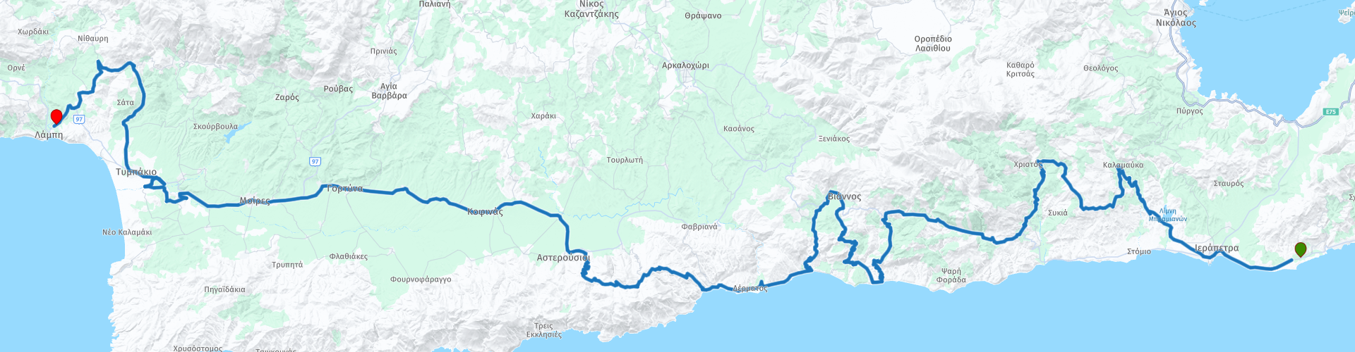
 The first visit can be scheduled to the museum in Hierapetra RP2. This museum houses the archaeological collection of Ierapetra, this collection originated in the late 19th century during the Turkish occupation of Crete and was housed in different buildings in the past. Today it is housed in the Commercial Ottoman School building. The collection includes:
• Minoan art: painted sarcophagi, lamps, pottery from the late Minoan III (1400-1200 BC), usually stirrup pots and craters.
• Geometric figures and pottery (9th-8th century BC).
• Archaic art: figurines and relief plates from the late 7th and 6th centuries BC.
• Classic and Hellenistic pottery and figurines from the end of the 1st century BC to the 4th century AD.
• Roman reliefs and statues.
• Grave and motif inscriptions from the ancient Greek and Roman times.
• Clay sarcophagus, found in a rock-hewn horseshoe-shaped tomb in the Epis Goedkoop area of Hierapetra, dating from 1450-1400 BC.
Via a nice narrow country road we drive towards the mountains. At RP4 you can turn right to stop for a photo at the dam and the artificial lake of Bramiana. This reservoir was built in 1986 near the village of Bramiana to supply the 30,000 greenhouses around Ierapetra. It is located 5 km northwest of the city, on the road connecting Ierapetra to the village of Kalamafka. The lake covers an area of 1050 hectares and has a capacity of 15 million m3, making it the second largest wetland area in southern Greece, after the Potami Dam in Amari. The best time to visit is in early spring, when the water level is at its peak. In the summer, the water level drops and sometimes the ruin of the church of the prophet Elijah is visible on the bottom of the lake.
We continue the drive to Kalamafka, this road winds through the mountains and is a series of curves, with a nice hairpin bend now and then. The asphalt is good but the road is narrow so watch out for oncoming traffic. Along the way you can enjoy the beautiful views.
Just before Kalamafka you can turn right at RP5 for a short photo stop the viewpoint at “the Holy Cross Timios Stavros”. We drive through the village of Kalamafka and then drive south again, again with beautiful panoramas.
At RP10 you can turn right to visit the Sarakinas Gorge. The length of this beautiful gorge is about 1.5 km and the width varies between 3 and 10 meters, but at a few points it reaches the lake. The height of the walls peaks at about 150 m. The Kriopotamos River flows through the gorge, which transports water at various levels throughout the year through humid winters and dry summers.
At RP13 you can stop for lunch at Diavatis Greek Restaurant. Then we drive downhill to the coast. Along the way you can enjoy the beautiful panoramas again, there is the possibility to stop safely in some places for a photo, such as with RP14. We then drive the coast from Keratokambos to Archanes for a long time. There are a number of small beaches along this road if you want to take a break.
We drive along a beautiful winding road with the necessary hair game bends along the mountain Asphandilia. Then visit the ruins of the Phaistos Palace (RP21). The palace was excavated at the beginning of the 20th century by the Italian archaeologist Halbherr. The earliest settlements on the site, which is close to the Yeropotamos, one of the few rivers in Crete that flow all year round, date back to the Neolothic Period (c. 4000 BCE). Probably, in the early Minoan period, small settlements were scattered on the hill on which the palace later stood. Dark on light pottery (Agios Onouphrios ware) has been found in the prepalatial levels on the hill, but no Vasiliki ware from the Early Minoan II period has been found on the site.
The old palace was built on the site at the beginning of the second millennium, known as the protopalatial period (c. 1900-1700 BCE). It took a lot of work to build the palace. First of all, three huge terraces were leveled. The palace was then built on two of these terraces, the Theatral Terrace and the Lower Terrace.
After this we drive via the town of Tympaki on a beautiful winding road through the mountains to the end of this beautiful day, the campsite “No Problem” in the beautiful seaside town of Agia Galini.
This route is worth 5 ***** Stars because of the beautiful roads, beautiful views and sights along the way.


 Links
Links  Usage
Usage Want to download this route?
You can download the route for free without MyRoute-app account. To do so, open the route and click 'save as'. Want to edit this route?
No problem, start by opening the route. Follow the tutorial and create your personal MyRoute-app account. After registration, your trial starts automatically.  Disclaimer
Use of this GPS route is at your own expense and risk. The route has been carefully composed and checked by a MyRoute-app accredited RouteXpert for use on TomTom, Garmin and MyRoute-app Navigation.
Changes may nevertheless have occurred due to changed circumstances, road diversions or seasonal closures. We therefore recommend checking each route before use.
Preferably use the route track in your navigation system. More information about the use of MyRoute-app can be found on the website under 'Community' or 'Academy'.

Crete
About this region
Crete (Greek: Κρήτη, Modern: Kríti, Ancient: Krḗtē, [krέːtεː]) is the largest and most populous of the Greek islands, the 88th largest island in the world and the fifth largest island in the Mediterranean Sea, after Sicily, Sardinia, Cyprus, and Corsica. Crete rests approximately 160 km (99 mi) south of the Greek mainland. It has an area of 8,336 km2 (3,219 sq mi) and a coastline of 1,046 km (650 mi). It bounds the southern border of the Aegean Sea, with the Sea of Crete (or North Cretan Sea) to the north and the Libyan Sea (or South Cretan Sea) to the south.
Crete and a number of islands and islets that surround it constitute the Region of Crete (Greek: Περιφέρεια Κρήτης), which is the southernmost of the 13 top-level administrative units of Greece, and the fifth most populous of Greece's regions. Its capital and largest city is Heraklion, located on the north shore of the island. As of 2020, the region had a population of 636,504. The Dodecanese are located to the northeast of Crete, while the Cyclades are situated to the north, separated by the Sea of Crete. The Peloponnese is to the region's northwest.
Humans have inhabited the island since at least 130,000 years ago, during the Paleolithic age. Crete was the centre of Europe's first advanced civilization, the Minoans, from 2700 to 1420 BC. The Minoan civilization was overrun by the Mycenaean civilization from mainland Greece. Crete was later ruled by Rome, then successively by the Byzantine Empire, Andalusian Arabs, the Venetian Republic, and the Ottoman Empire. In 1898 Crete, whose people had for some time wanted to join the Greek state, achieved independence from the Ottomans, formally becoming the Cretan State. Crete became part of Greece in December 1913.
The island is mostly mountainous, and its character is defined by a high mountain range crossing from west to east. It includes Crete's highest point, Mount Ida, and the range of the White Mountains (Lefka Ori) with 30 summits above 2000 metres in altitude and the Samaria Gorge, a World Biosphere Reserve. Crete forms a significant part of the economy and cultural heritage of Greece, while retaining its own local cultural traits (such as its own poetry and music). The Nikos Kazantzakis airport at Heraklion and the Daskalogiannis airport at Chania serve international travelers. The palace of Knossos, a Bronze Age settlement and ancient Minoan city, is also located in Heraklion.
Read more on Wikipedia
Crete and a number of islands and islets that surround it constitute the Region of Crete (Greek: Περιφέρεια Κρήτης), which is the southernmost of the 13 top-level administrative units of Greece, and the fifth most populous of Greece's regions. Its capital and largest city is Heraklion, located on the north shore of the island. As of 2020, the region had a population of 636,504. The Dodecanese are located to the northeast of Crete, while the Cyclades are situated to the north, separated by the Sea of Crete. The Peloponnese is to the region's northwest.
Humans have inhabited the island since at least 130,000 years ago, during the Paleolithic age. Crete was the centre of Europe's first advanced civilization, the Minoans, from 2700 to 1420 BC. The Minoan civilization was overrun by the Mycenaean civilization from mainland Greece. Crete was later ruled by Rome, then successively by the Byzantine Empire, Andalusian Arabs, the Venetian Republic, and the Ottoman Empire. In 1898 Crete, whose people had for some time wanted to join the Greek state, achieved independence from the Ottomans, formally becoming the Cretan State. Crete became part of Greece in December 1913.
The island is mostly mountainous, and its character is defined by a high mountain range crossing from west to east. It includes Crete's highest point, Mount Ida, and the range of the White Mountains (Lefka Ori) with 30 summits above 2000 metres in altitude and the Samaria Gorge, a World Biosphere Reserve. Crete forms a significant part of the economy and cultural heritage of Greece, while retaining its own local cultural traits (such as its own poetry and music). The Nikos Kazantzakis airport at Heraklion and the Daskalogiannis airport at Chania serve international travelers. The palace of Knossos, a Bronze Age settlement and ancient Minoan city, is also located in Heraklion.
View region
 Statistics
  8
8Amount of RX reviews (Crete)
 6930
6930Amount of visitors (Crete)
 310
310Amount of downloads (Crete)
 Route Collections in this region
 Eight beautiful routes in Crete Greece
This is a collection of 8 routes for an 8-day tour on the Greek island of Crete.
Motorcycling in Crete is a real pleasure, this island has many beautiful winding roads with thousands of bends, idyllic villages, beautiful views of the sea, bays, beautiful passes and ravines.
The locals are very hospitable. The roads are decent, but it is advisable to rent an All or Off Road motorcycle, as there are also many bad roads with potholes and unpaved areas.
On the very tourist island there are many hotels, especially along the coast, there are also B&B and a number of campsites. In these routes we assume camping accommodation.
The routes can be driven by motorcycle, car or quads and there are several rental companies in Crete where you can rent All Road, Custom, Quads, Buggies, scooters and cars.
View Route Collection