18 Dr Picardtroute

This route was brought to you by:
RouteXpert Hans van de Ven (Mr.MRA)
Last edit: 27-03-2025
 Route Summary
 This is the 18th in a series of 43 Endangered ANWB routes. These were published in the Promotors between April 2015 and September 2016.
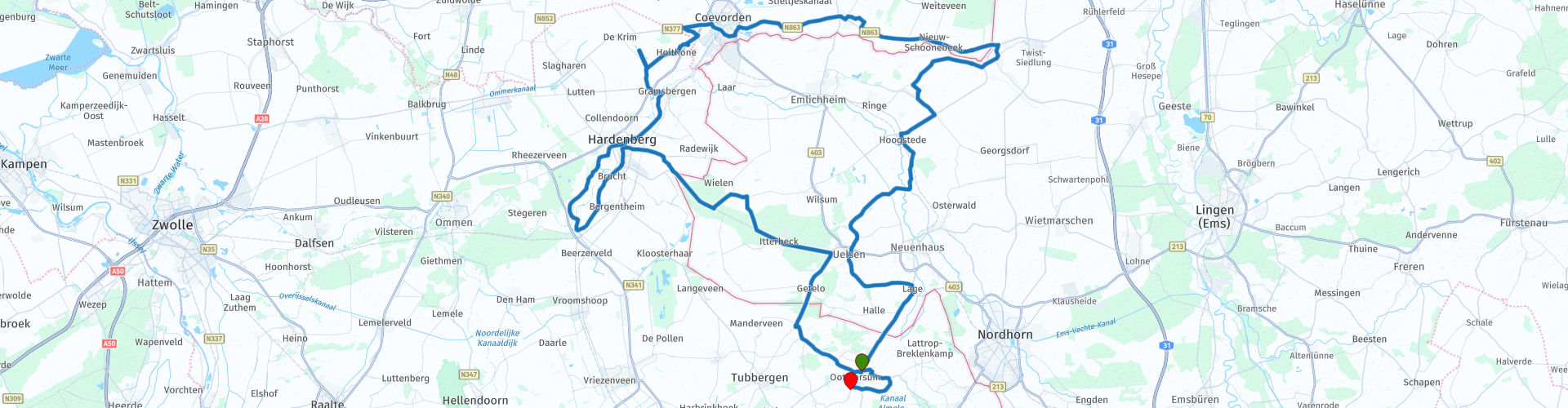
Starting point: Twente Tour (Ootmarsum)
End point: Café-Restaurant Max Groot Agelo
I awarded this route 3 ★★★ stars because the scenery and attractions are excellent, and the roads are very well maintained and varied.
Region: Twente & Grafschaft Bentheim (Germany)
 Share this route


Animation

Verdict


Duration
4h 7m

Mode of travel
Car or motorcycle

Distance
155.28 km

Countries


 RouteXpert Review
 Your engine hums softly as you set off from Twente Toer in Ootmarsum, a place where tourism lives. After a few bends you are already at the first highlight: Watermill De Mast. This old undershot mill is romantically hidden along a stream. Then you cross the border at Vasse, into Germany, where the landscape becomes more undulating. You meander over quiet country roads through the Uelsener Berge. Here you see sandstone formations, forests and hills that are reminiscent of the Eifel. Perfect asphalt, hardly any traffic. Then you follow a series of beautiful bends towards Itterbeck, Wielen and Bergentheim. A mix of asphalt ribbons, rural vistas and unexpected views. You drive into the Vechtdal and make a photo stop at the Tour Foto Punt Distelbelt: heathland, forest and drifting sand form a backdrop here that invites you to get off. Via Diffelen and Hardenberg you arrive at the Loozensche Linie, a military heritage piece that has been surprisingly well preserved. From there you drive via winding roads to the Vloeivelden De Krim Observation Tower, where you have a view of a unique swamp area full of birds.
Then follow Coevorden and Weijerswold, where you end up at Wegrestaurant Otten. Dutch food, quick service and an ideal Tour Pause Point to recharge. Then it is time to drive back into Germany. Via Schoonebeek and Twist you cross the mysterious Hochmoor Ringe - an extensive peat area where the mist sometimes hangs above the plains. The silence here is almost tangible. In Uelsen you visit the Windmühle, a characteristic mill on a hill, with original grinding tools inside. A beautiful Tour Photo Point. After a winding finale through the German countryside you return to the Netherlands via Halle and Tilligte. You end the route in style at Café-Restaurant Max in Groot Agelo. On the terrace you can enjoy regional dishes, a good glass or just a strong espresso. What a ride.
The Dr Picardtroute is groundbreaking – literally and figuratively. You drive through two countries, two landscapes and along a wealth of cultural history. From mills to marshes, from Twente hospitality to German hill roads: this route has it all. The roads are of excellent quality, easy to drive on and surprisingly winding. Ideal for those who want to tour and experience. Take your time, stop at the many Tour Info Points, and be surprised by what the border region has to offer.
Tip: Ride this route on a clear day with little wind – then you can see far across the fields and even hear the birds singing in the raised bog.


 Links
Links  Usage
Usage Want to download this route?
You can download the route for free without MyRoute-app account. To do so, open the route and click 'save as'. Want to edit this route?
No problem, start by opening the route. Follow the tutorial and create your personal MyRoute-app account. After registration, your trial starts automatically.  Disclaimer
Use of this GPS route is at your own expense and risk. The route has been carefully composed and checked by a MyRoute-app accredited RouteXpert for use on TomTom, Garmin and MyRoute-app Navigation.
Changes may nevertheless have occurred due to changed circumstances, road diversions or seasonal closures. We therefore recommend checking each route before use.
Preferably use the route track in your navigation system. More information about the use of MyRoute-app can be found on the website under 'Community' or 'Academy'.