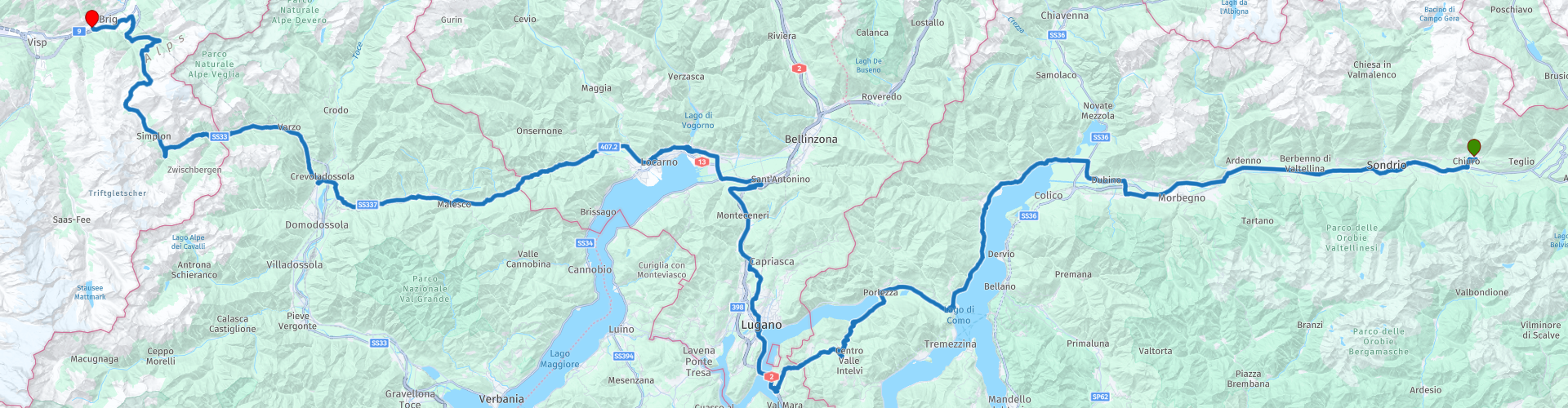
R02 - Chiuro to Brig

This route was brought to you by:
RouteXpert Arno van Lochem - Senior RX
Last edit: 25-08-2021
 Route Summary
 The route starts at Hotel / Pizzeria La Svolta and passes by Lake Como, Lake Lugano and Lake Maggiore. You will cross the border between Italy and Switzerland a number of times before ending up in the Swiss town of Brig at the sports & wellness hotel Olympia.
The route is for the more advanced motorcyclist given the occasional tight hairpin bends in the Alps. Good engine management is desired!
 Share this route


Animation

Verdict


Duration
6h 11m

Mode of travel
Car or motorcycle

Distance
279.24 km

Countries


 RouteXpert Review
 The route starts at Hotel La Svolta in Chiuro, a town in the Sondrio Valley. A river, the Adda, also meanders through this valley. This river has its source on the Stelvio and finds its way through the valley towards Lake Como. The route follows this river to Lake Como.
Lake Como is a lake with an area of 146 km² and is the third largest of the Italian Alpine lakes. The lake is of glacial origin and is located at a height of 198 meters, the maximum depth is 425 meters. This makes Lake Como the deepest lake in Italy.
The largest water supply is the aforementioned river Adda, which enters the lake in the north at Colico and leaves it in the southeast at Lecco.
Along Lake Como you will find numerous small villages from which you have a beautiful view over the lake. In one of these villages, Gravedona, it is worthwhile to stop and enjoy the view over the water for a moment. On one side the quay with the restaurants and shops, on the other side the mountains that rise from the water.
A few kilometers further in the village of Dongo you will find a real Italian cafe, San Gottardo. The kind of cafe where the waitress is shouting to the kitchen what has been ordered with a quick Italian accent. Great to see and hear. On the other side of the street you see a small harbor with a few boats in it, always nice for a photo.
After coffee you continue the route along Lake Como. At Mennagio, Lake Como is left and you follow the SS340 towards Porlezza, a small town on the Italian side of Lake Lugano.
Lake Lugano is a lake in southeastern Switzerland, on the border between Switzerland and Italy. The lake bears the name of the largest city on its shores, Lugano, and is located between Lake Como and Lake Maggiore. The lake drains into Lake Maggiore via the Tresa. The deepest point, 288 meters, is just past Gandria in the Italian part of the lake. The area is 48.7 km².
In 1848 a dike was built over the lake, between Melide and Bissone, the Melidedijk. This made a direct connection between Lugano and Chiasso possible. The Gotthard railway and the A2 motorway now run across the dyke. The dike divides the lake into two basins, a 27.5 km² large northern basin and a 21.4 km² southern basin. A canal with bridges allows water flow and shipping.
An ice cream parlor is located in Porlezza, which has become famous in the region. The ice cream that is made there tastes the best in the whole area, according to insiders. It is of course best to test it yourself. While enjoying your ice cream you have a great view over Lake Lugano.
If you want to visit this ice cream parlor Visconti, do not turn left after RP6, but drive straight ahead and turn right at the roundabout. After 100m you will find 'Gelateria Visconti' on the right. It is hidden between the two adjacent buildings, but can be recognized by the colorful awnings in front of the windows with the inscription 'Gelateria' and 'Bar'.
After this cold break you continue the route through a beautiful winding road which after about 15 kilometers ends at a number of very short and sharp hairpin bends. Pay close attention to this, it can just happen that you meet a motorist on your side of the road.
While driving these tight hairpin bends you have also crossed the Italian-Swiss border. Switzerland is known for its high fines for speeding, so take it easy! At Maroggia the route again runs along Lake Lugano, now along the southern basin. The Melidedijk mentioned above also comes into the picture, the route runs over it.
At the end of this dike you will find Swiss Miniature on the left. You can compare this with Madurodam, but for Switzerland. Many typical features of Switzerland have been recreated in miniature in this park. Model train enthusiasts will love the G scale trains that run through the park. In the surrounding park you also have a beautiful view over the water.
From RP12, a few kilometers further along the route, you can enjoy Lake Lugano in all its glory. The clear water, the activity on the lake, the city built against the slopes, the imposing mountains around you. Great location to look around you in peace and quiet in what beautiful surroundings you have ended up.
In the city you will pass the exhibition 'Dal tam-tam alla radio digital', which shows 100 years of inventions in communication. The creators of the exhibition define it as a path. In fact, within a few meters of display, we trace more than 100 years of our history, through the presence of historic radio sets and various means of communication. Nice to visit and educational too!
In Gordola you can choose to turn right and visit the Verzasca dam. In addition to a great view over the water and the valley, there is the possibility to have an elastic band tied to your ankles, after which you are kindly requested to jump off a plank: Bungee Jumping!
James Bond connoisseurs may recognize this place. In the movie 'Golden Eye' the British Secret Agent jumped off a dam. Those recordings were made here. So if you want, you can experience what that feels like, just like James Bond. I skipped it and only enjoyed the great view ... :-)
The route passes Locarno. From RP18 in the route you have a great view of the third lake during this route: Lake Maggiore. The lake is 212 km², 60 km long, the widest point is 10 km and the maximum depth is 372 meters. In both Italy and Switzerland it is more in the Italian-speaking area. The lake, like the other large Italian alpine lakes, was carved out by a glacier in one of the ice ages.
Professional fishermen also live on the lake. About 150 tons of fish are caught per year, including a trout species that is found nowhere else in the world.
The lake has long been an important tourist attraction. In the 19th century, the European nobility settled en masse in luxury hotels or built their own villas, often with a botanical garden such as in Alpino, Baveno or Pallanza. Thus, an exotic plantation has developed along the shores of the entire lake, with mainly different types of palms.
Further along the route you will pass the Palagnedra lake. This is a lake that, unlike the previous lakes along which the route passes, was created artificially by building a dam in the river Melezza. Due to this dam, the river burst its banks for a few kilometers and the lake was created. Employment and regulation of the amount of water in the river behind were the main reasons for building this 72m high dam in 1952. You have a nice view over the dam at RP21.
10 kilometers further - now you are driving in Italy again - a basilica suddenly appears on the route, the 'Santuario della Madonna del Sangue', or the 'Sanctuary of the Madonna del Sangue'. This shrine is dedicated to the Virgin Mary and it was built on the site where a miracle took place in 1494: a small mural of the nursing Madonna was hit by a stone during a rally and began to bleed. That is why this sanctuary is the destination of many pilgrimages from the area.
A visit to the basilica is worthwhile. Impressive from the outside, inside a very beautiful modern church that has integrated the former older church, as it were.
The route meanders for another 20 kilometers along the Melezza to eventually turn northwest at Masera. Shortly afterwards, after crossing the border with Switzerland again, the only significant pass in this route is conquered, the Simplon Pass with a height of 2005 meters.
The Simplon Pass connects the Rhone Valley in the Swiss canton of Valais with the Val d'Ossola in the Italian province of Verbano-Cusio-Ossola. The pass was first used extensively in the early Middle Ages as a trade route between Italy and France. Napoleon had the road completely renovated so that he could cross it with his artillery. The current Simplon Pass is one of the best constructed mountain passes in Europe, with an average road width of 6 meters. The pass remains open in winter.
The town of Brig, the final destination of this route, is reached via the Ganter Bridge. This is a reinforced concrete bridge with multiple spans. With a length of 678 meters, it is the second longest spanning bridge in Switzerland. The bridge, with a maximum height of 150 meters, is located across the valley of the Ganter River and along the Simplon Pass, which you have just crossed. Construction started in 1976 and was completed in 1980.
After leaving this bridge you reach the town of Brig a little further. Shortly in front of the hotel, the route passes a motorcycle shop, Bärenfaller Moto-Shop. If you need to, you can visit this shop, there are a few people at work who know what they are talking about.
Have fun on this route!


 Links
Links  Usage
Usage Want to download this route?
You can download the route for free without MyRoute-app account. To do so, open the route and click 'save as'. Want to edit this route?
No problem, start by opening the route. Follow the tutorial and create your personal MyRoute-app account. After registration, your trial starts automatically.  Disclaimer
Use of this GPS route is at your own expense and risk. The route has been carefully composed and checked by a MyRoute-app accredited RouteXpert for use on TomTom, Garmin and MyRoute-app Navigation.
Changes may nevertheless have occurred due to changed circumstances, road diversions or seasonal closures. We therefore recommend checking each route before use.
Preferably use the route track in your navigation system. More information about the use of MyRoute-app can be found on the website under 'Community' or 'Academy'.

Ticino
About this region
Ticino (), sometimes Tessin (), officially the Republic and Canton of Ticino or less formally the Canton of Ticino, is one of the 26 cantons forming the Swiss Confederation. It is composed of eight districts and its capital city is Bellinzona. It is also traditionally divided into the Sopraceneri and the Sottoceneri, respectively north and south of Monte Ceneri. Red and blue are the colours of its flag.
Ticino is the southernmost canton of Switzerland. It is one of the three large southern Alpine cantons, along with Valais and the Grisons. However, unlike all other cantons, it lies almost entirely south of the Alps. Through the main crest of the Gotthard and adjacent mountain ranges, it borders the canton of Valais to the northwest, the canton of Uri to the north and the canton of Grisons to the northeast; the latter canton being also the only one to share some borders with Ticino at the level of the plains. The canton shares international borders with Italy as well, including a small Italian enclave.
Named after the Ticino, its longest river, it is the only canton where Italian is the sole official language and represents the bulk of the Italian-speaking area of Switzerland along with the southern parts of the Grisons. In 2020, Ticino had a population of 350,986. The largest city is Lugano, and the two other notable centres are Bellinzona and Locarno. The canton is a major tourist destination and is renowned for its distinct culture and gastronomy, and also for its warmer climate, especially around Lake Maggiore and Lake Lugano.
The land now occupied by the canton was annexed from Italian cities in the 15th century by various Swiss forces in the last transalpine campaigns of the Old Swiss Confederacy. In the Helvetic Republic, established 1798, it was divided between the two new cantons of Bellinzona and Lugano. The creation of the Swiss Confederation in 1803 saw these two cantons combine to form the modern canton of Ticino. Because of its unusual position, the canton relies on important infrastructures for connections with the rest of the country. The first major north-south railway link, the Gotthard Railway, opened in 1882. In 2016, the Gotthard Base Tunnel, the first flat route through the Alps, was inaugurated.
Read more on Wikipedia
Ticino is the southernmost canton of Switzerland. It is one of the three large southern Alpine cantons, along with Valais and the Grisons. However, unlike all other cantons, it lies almost entirely south of the Alps. Through the main crest of the Gotthard and adjacent mountain ranges, it borders the canton of Valais to the northwest, the canton of Uri to the north and the canton of Grisons to the northeast; the latter canton being also the only one to share some borders with Ticino at the level of the plains. The canton shares international borders with Italy as well, including a small Italian enclave.
Named after the Ticino, its longest river, it is the only canton where Italian is the sole official language and represents the bulk of the Italian-speaking area of Switzerland along with the southern parts of the Grisons. In 2020, Ticino had a population of 350,986. The largest city is Lugano, and the two other notable centres are Bellinzona and Locarno. The canton is a major tourist destination and is renowned for its distinct culture and gastronomy, and also for its warmer climate, especially around Lake Maggiore and Lake Lugano.
The land now occupied by the canton was annexed from Italian cities in the 15th century by various Swiss forces in the last transalpine campaigns of the Old Swiss Confederacy. In the Helvetic Republic, established 1798, it was divided between the two new cantons of Bellinzona and Lugano. The creation of the Swiss Confederation in 1803 saw these two cantons combine to form the modern canton of Ticino. Because of its unusual position, the canton relies on important infrastructures for connections with the rest of the country. The first major north-south railway link, the Gotthard Railway, opened in 1882. In 2016, the Gotthard Base Tunnel, the first flat route through the Alps, was inaugurated.
View region
 Statistics
  10
10Amount of RX reviews (Ticino)
 14746
14746Amount of visitors (Ticino)
 1135
1135Amount of downloads (Ticino)
 Route Collections in this region
 The 24 Most Beautiful Alpine Routes
The Alps, The Alps are a mountain range in Europe, stretching from the French Mediterranean coast in the southwest to the Pannonian Plain in the east. The area of the mountain range is more than 200,000 km².
In other words Passes and Mountain Roads!
Driving through the mountains is great! Especially over the mountain passes with hairpin bends and narrow winding roads. Every bend a different view where you can enjoy. There are many beautiful mountain passes in the Alps.
A selection that has also been incorporated into these routes:
The Stlevio Pass:
The Stelvio Pass, also known as Passo dello Stelvio, is mainly known for the stage in the Giro d'Italia. Due to the length and the difference in height, this pass is seen as one of the toughest tests in cycling. The Stelvio Pass reaches a maximum height of 2758 meters and is therefore one of the highest in the Alps. The pass connects the towns of Bormio and Prato Allo Stelvio. In winter the pass is closed due to heavy snowfall.
The Reschenpass:
The Reschenpass, also known as Passo di Resia, connects the Austrian state of Tyrol with the Italian province of South Tyrol. The pass reaches a maximum height of 1,504 meters and has been one of the most important north-south connections in the Alps in recent centuries. The pass was used long before Roman times. Along the way you will pass several highlights and historical relics. One of the highlights is the Reschensee. This lake was created after the construction of the dam and has completely submerged the village of Graun. The only thing that reminds of that is the clock tower in the middle of the lake.
Col du Galibier:
The French mountain pass Col du Galibier connects the towns of Saint-Michel-de-Maurienne and Briançon via the Col du Lautaret in the south and the Col du Télégraphe in the north. The mountain pass is part of the Tour de France and very much feared, due to the fact that it can only be reached via the other two mountain passes. The pass reaches a maximum height of 2646 meters. From there you can take a walk to the viewpoint at 2704 meters. You can admire the peaks of the Grand Galibier, Mont Blanc and La Meije here.
The Grossglockner High Alpine Road:
With a height of 3798 meters the Grossglockner is the highest mountain in Austria. To fully enjoy this impressive mountain, you can drive over the Grossglockner High Alpine Road and the accompanying pass. The route starts from Bruck am Grossglockner and ends in Heiligenblut. Of course you can drive in two directions. The pass reaches a maximum height of 2504 meters and is closed in winter due to heavy snowfall. Along the way you pass several stops with fun activities, information points, mountain huts and viewpoints. A visit to the Kaiser-Franz-Josefs-Höhe and Pasterzen Glacier is highly recommended.
The Col d'Izoard:
Just like the Col du Galibier, the Col d'Izoard is also part of a stage of the Tour de France. The mountain pass connects Briançon with the valley of the river Guil. The pass is partly located in the Regional Natural Park du Queyras and reaches a maximum height of 2360 meters. What is special about the Col d'Izoard is the barren and rocky landscape. Sometimes it feels like driving a car over the moon! Along the way you can stop at several points to enjoy the beautiful view.
The Bernina Pass:
The Bernina Express is one of the most famous rail trains in Switzerland and the Alps. The route is beautiful and partly included on the UNESCO World Heritage List. Parallel to the railway lies the Bernina pass, which connects the Veltlin valley with the Egandin valley. This beautiful Alpine road has a total length of 56 kilometers and reaches a maximum height of 2328 meters. Along the way you can enjoy views of the Morteratsch Glacier.
The Sella Pass:
The Sella Pass, also known as Passo di Sella, takes you over one of the most impressive mountain ranges in the Dolomites: the Sella massif. The pass connects Valle di Fassa with Val Gardena and reaches a maximum height of 2236 meters. At this height is also the border of the Italian provinces of Trentino and Bolzano. Along the way you can enjoy the view of this spectacular mountain world. Admire, for example, the three peaks of the Sasso Lungo massif, the Sella massif or the peaks of the Marmolada. You can also drive the Sella pass in combination with the Gardena pass, Pordoi pass and Campolongo pass.
The Grimsel Pass:
The Grimsel Pass connects Goms in Wallis with the Halis Valley in the Bernese Oberland. The pass reaches a maximum elevation of 2165 meters and is closed in winter due to snowfall. Over the centuries, the mountain pass has played an important role in trade between Switzerland and Italy. Now it is mainly the reservoirs that have an important function. These are used to generate electricity. The landscape you drive through is rugged, rocky and impressive. On top of the pass is a hotel and a restaurant with a special marmot park. The Dodensee (Totensee) is also located here. This lake owes its name to the many soldiers who died in the time of Napoleon.
The Gotthard Pass:
The Gotthard Pass, also known as Passo del San Gottardo and Saint Gotthard, connects the Swiss towns of Airolo and Andermatt. The mountain pass and associated tunnel are especially known among holidaymakers driving from Switzerland to Italy. But where the majority opt for the tunnel, it is precisely the pass that really completes the holiday. The Gotthard Pass has a length of about 26 kilometers and reaches a maximum height of 2106 meters. The route is beautiful and takes you along old villages and beautiful views.
The Silvretta High Alpine Road and Silvretta Pass:
The Paznaun Valley in Tyrol and the Montafon in Vorarlberg are connected by the Silvretta High Alpine Road. The route has a length of 22.3 kilometers and leads from Galtür to Partenen in 34 hairpin bends, via the 2032 meter high Bielerhöhe. The Silvrettasee is also located at this point, where you can enjoy a lovely walk. The pass is closed in winter due to snowfall.
The Simplon Pass:
Just like the Gotthard Pass, many holidaymakers also travel over the Simplon Pass every year. This mountain pass connects the Rhone Valley in the canton of Valais with the Valle d'Ossola in Piemonte. The pass is open all year round and reaches a maximum height of 2005 meters. Along the way you pass a number of buildings, including the well-known Simplon Hospiz from 1825. The hospiz is managed by the monks of St. Bernard. From the highest point on the pass, all kinds of hiking routes are possible and you will also come across a hotel where you can spend the night.
The Gerlos Pass:
The Gerlos Pass connects the Salzach Valley in the Salzburgerland with the Zillertal Valley in Tyrol. The pass is part of the Gerlos Alpenstraße and runs right through the Hohe Tauern National Park. Along the way you can enjoy beautiful views of the surroundings. The pass has a length of 12 kilometers and reaches a maximum height of 1531 meters. A ride over the Gerlos Pass can be ideally combined with a visit to the Krimmler Wasserfälle.
The Great St. Bernard Pass:
The Great St. Bernard Pass, better known as Col du Grand Saint Bernard, connects the Italian province of Valle d'Aosta with the Swiss canton of Valais. The pass is one of the highest in Switzerland and reaches a maximum height of 2469 meters. Like a number of other mountain passes in this list, the Great St. Bernard Pass has also been used as a connecting road for centuries. The pass is named after the St. Bernard dogs that used to help stranded travelers along with the monks. The pass is closed in winter.
The Timmelsjoch High Alpine Road:
The Timmelsjoch High Alpine Road connects the towns of Sölden in the Ötztal and Meran in South Tyrol. Tolls must be paid on the Hochgurgl - Moos route. Via a mountain road with about 60 hairpin bends you drive through a beautiful mountain world. With the Timmelsjoch Experience you can learn more about the history, the road and the environment via various stations. You can also visit the Top Mountain Crosspoint museum.
Col de l'Iseran:
With a maximum pass height of 2770 meters, the Col l'Iséran is one of the highest mountain passes in the Alps. The pass connects Bourg-Saint-Maurice with Bonneval-sur-Arc. Via a road full of hairpin bends you pass, among other things, Val-d'Isère and a side valley of the Maurienne that lies entirely in the National Park de la Vanoise. You can spot animals such as marmots and chamois and there is also a restaurant with a chapel on top of the pass.
The Gavia Pass:
The Gavia Pass (Italian Passo di Gavia) is a mountain pass in the Italian Alps, in the Lombardy region.
It is one of the highest pass roads in Europe. The road leads through the unspoilt Stelvio National Park. The road was built in the First World War to supply Italian soldiers who fought in the Italian-Austrian border area. The pass height is one of the most beautiful in the Alps. Here is the large Lago Bianco with, to the north, the mountain San Matteo (3684 meters). Lago Nero is slightly lower on the south side of the pass. Here the mountain group of the Adamello determines the view. There are many well-marked walks in the area. During the winter the pass is closed due to the heavy snowfall. The pass is often closed until May and June due to the large amount of snow.
Promoter has made a selection of the 24 Most Beautiful Alpine routes that they have set out in recent years.
The routes go through:
France
Austria
Switzerland
Italy
The most beautiful roads, the most beautiful views, the most beautiful viewpoints. The highest mountains, the fastest descents, hairpin bend after hairpin bend, you name it you can't get enough of it.
If you go on holiday in this region, take advantage of it, ALL routes in this collection have been checked and made equal for TomTom, Garmin and MyRoute-app Navigation by a MyRoute-app RouteXpert.
Have fun with this collection and while driving one of these routes. Enjoy all the beauty that the Alps and the Dolomites have to offer. Click on “View route” to read the review of the chosen route.
I would like to hear your findings about the route(s).
View Route Collection
Pass Parade Alps and Dolomites
The Alps, a mountain range in Europe that stretches from the French Mediterranean coast in the southwest to the Pannonian plain in the east, almost always guarantee beautiful routes. It can hardly be boring there. The many passes, vistas and variations in the landscape make the Alps a true motorcyclist's paradise. Driving around in the Alps is really quite an experience. You haven't gone through one bend yet or the next one is already on its way. Climbing from the valley, see the landscape change from wooded slopes with splashing waterfalls to alpine meadows where no trees can be found and asphalt roads that cut through the eternal snow. Arriving on top of the mountain, enjoy phenomenal views over the surrounding snow-capped peaks, as if you were on the roof of the world.
The Dolomites also form a fantastic mountain world. They are located east of the Eisacktal, through which the “Brenner Autobahn” runs, which only ends at Bolzano. The area is located in the southernmost part of the Alps, but offers a fantastic, often rugged and unreal sight due to the huge rocky peaks. Peaks that rise steeply above the green wooded slopes and Almen. Truly breathtakingly beautiful roads have been built between the peaks.
How nice would it be if these two areas were strung together by a number of routes that take in a selection of the most beautiful passes in both areas? This collection provides you with that. Starting point is the Postillion Hotel in Arnhem, where you can visit both these beautiful areas in 10 days/routes and get 35 great passes under your wheels. The 'big boys' such as the Stelvio, Timmelsjoch, Pordoi and Gardena are on the list, but also the less well-known passes in the south of the Dolomites, such as the Passo Staulanza, the Passo Rolle and the Passo Duran. In the meantime, visiting the highest asphalted point in Austria at 2829 meters is also possible. After more than 3100 kilometers you end up at the Postillion Hotel in Arnhem.
A number of sights are discussed in the review for each route. These often tell you what you see and what to do. Fun facts, quite educational. Often there are also places indicated where you can find some entertainment, for example a suspension bridge at a great height. You are completely free to visit these sights, you can of course also determine your own points of interest.
But the main thing you most likely traveled to these areas for is simply driving. And as mentioned above, you are in a true motorcycle paradise where the steering is fantastic!
Each route ends at a hotel. It is of course not an obligation to use these hotels, you can always find another place to stay in the area, that is entirely up to you. However, my experience is that they are all simple but good hotels for a very reasonable price. They are known at/can be booked via booking.com (subject to change)
The routes of these collections:
R01 Arnhem to Riol, 355km
R02 Riol to Voehrenbach, 311km
R03 Voehrenbach to Innertkirchen, 257km
R04 Innertkirchen to Susch, 303km
R05 Susch to Selva di Val Gardena, 301km
R06 Selva di Val Gardena to Castello Molina di Fiemme, 272km
R07 Castello Molina di Fiemme to Reutte, 289km
R08 Reutte to Voehrenbach, 273km
R09 Voehrenbach to Riol, 367km
R10 Riol to Arnhem, 341km
Have fun driving these routes!
View Route Collection