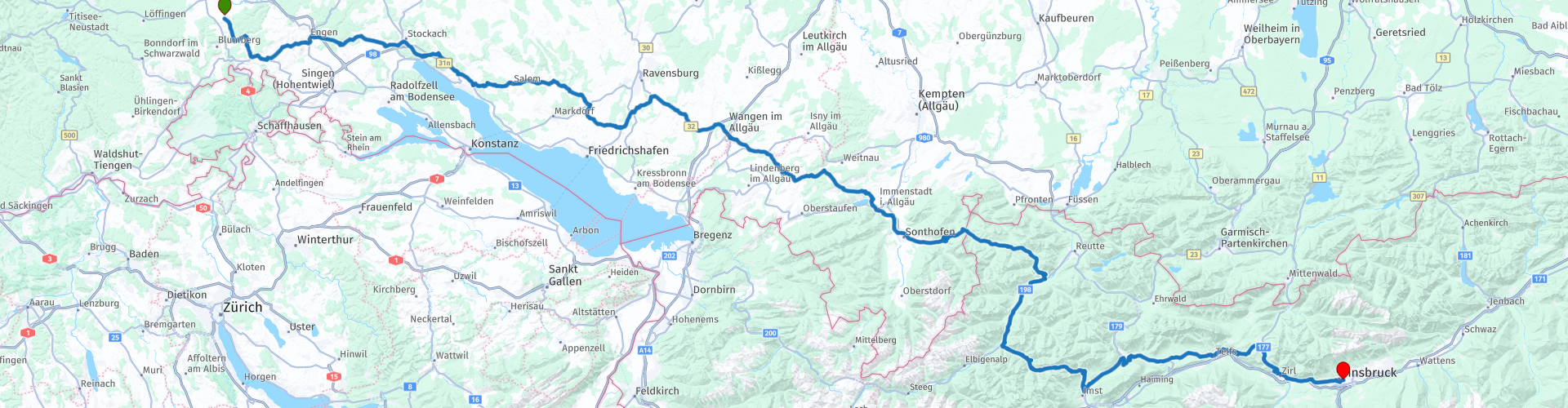
R07 - Fuerstenberg to Innsbruck

This route was brought to you by:
RouteXpert Arno van Lochem - Senior RX
Last edit: 17-02-2021
 Route Summary
 Austria is of course known for its beautiful mountains, the last part of this route takes you through the beautiful Alps.
The route ends in Innsbruck at the loading dock of the OEBB, the Österreichische Bahn.
The route is for the more advanced motorcyclist given the occasional tight hairpin bends. Good engine management is desired!
 Share this route


Animation

Verdict


Duration
6h 12m

Mode of travel
Car or motorcycle

Distance
334.75 km

Countries


 RouteXpert Review
 The route starts in Fürstenberg, located in the beautiful Black Forest. There you immediately look for the beautiful roads, which is not difficult in this area. On beautiful winding roads yet the beautiful hilly landscape you will soon arrive in the town of Engen, where the Oldtimer and Fahrzeugmuseum is located.
In the Oldtimer- und Fahrzeugmuseum Engen you will find a large number of old-timers - from unrestored barn finds to first-class restored pre-war vehicles.
The museum was founded in early 2013 by about 20 people with a common interest: Classic cars. In the museum, numerous old-timers with two, three or four wheels can be seen in regularly changing exhibitions on a variety of subjects. See the link below for opening hours and admission prices.
Although the route does not run along Lake Constance, it does include a route point (RP8) where you can deviate from the route in order to drive along Germany's largest lake. Follow the B31 for this, you will then drive along the Bodensee.
This lake with an area of 536 square kilometers is located in the border area of Germany, Austria and Switzerland and consists of three parts: the Obersee, the Untersee and a 4 km long connecting canal.
Only in very severe winters does Lake Constance freeze over. Locally this is called a 'Seegefrörne'. In some years the frost is so severe that Lake Constance can be safely entered by a large crowd. When this occurs, it has been tradition since 1573 for a wooden bust of the evangelist John to be exchanged in procession across the ice between the Hagnau presbytery in Germany and the Münsterlingen monastery in Switzerland. This ice procession last took place on February 13, 1963.
To get back on the route from Lake Constance, you can follow the B33 at the town of Stetten, which will bring you back on the route at Hefigkofen.
Another option is to continue on the B31 to Friedrichshafen and then follow the B30 until you get back on the route just after Senglingen.
Just before entering Austria over the 1176 meter high Oberjochpass, you have to cover a circuit-like stretch of asphalt of about five kilometers. Almost at the end of this you will pass Aussichtspunkt Kanzel which gives you a beautiful view over Bad Hindelang and the Ostrach valley. Of course you also have a great view over the valley and the surrounding mountain peaks. Really recommend!
As mentioned, you drive into Austria via the Oberjochpass. A few kilometers further you will pass the Haldensee. The Haldensee is a small lake located at an altitude of 1224 meters in the Tannheimer Tal. On the west bank of the lake is the village of the same name Haldensee, on the east side the village of Haller. The lake is an important recreation spot in the area. A hotel and a camping site can be found on the shore of the lake.
You have a beautiful view over this lake from the Berghütte Adlerhorst. This cabin can be reached via a cable car in the village of Haller. At the bottom you can park the motorbike, after which the gondola will take you up to the mountain hut to enjoy the said beautiful view. For more information see the link below.
Once you have arrived at the bottom of the village you continue the route. On truly phenomenal steering roads you come across the Gaichtpass, the Hahntennjoch, the Holzleitensattel and the Seefelder Sattel. After every bend or mountain a different great view. Don't forget to stop every now and then to capture these beautiful moments.
Although you will get close to Innsbruck at the end of the route, it continues to steer very nicely for this city until recently. Only the last 6 kilometers do you notice that you have arrived in an urban area. Just before you cross the Inn you will pass a gas station. Here you can quickly fill the tank with fuel at the interesting Austrian prices.
Just after the refueling stop you cross the Inn as just said. This is the river from which this city got its name. The Inn is a river that flows through France, Austria and Switzerland and is one of the main drainage routes of the Alps. With its 517 kilometers it is not a small stream.
The last two kilometers of the route pass through the center of Innsbruck. Lots of traffic lights, vehicular traffic, cyclists, and pedestrians! Some caution is advisable here.
Have fun driving this route!


 Links
Links  Usage
Usage Want to download this route?
You can download the route for free without MyRoute-app account. To do so, open the route and click 'save as'. Want to edit this route?
No problem, start by opening the route. Follow the tutorial and create your personal MyRoute-app account. After registration, your trial starts automatically.  Disclaimer
Use of this GPS route is at your own expense and risk. The route has been carefully composed and checked by a MyRoute-app accredited RouteXpert for use on TomTom, Garmin and MyRoute-app Navigation.
Changes may nevertheless have occurred due to changed circumstances, road diversions or seasonal closures. We therefore recommend checking each route before use.
Preferably use the route track in your navigation system. More information about the use of MyRoute-app can be found on the website under 'Community' or 'Academy'.

Bavaria
About this region
Bavaria (; German: Bayern, [ˈbaɪɐn]; also Bavarian: Boarn), officially the Free State of Bavaria (German: Freistaat Bayern, [ˈfʁaɪʃtaːt ˈbaɪɐn] (listen); Bavarian: Freistoot Boarn), is a federal state in the south-east of Germany. With an area of 70,550.19 square kilometres (27,239.58 sq mi), Bavaria is the largest German state by land area, comprising roughly a fifth of the total land area of Germany. With over 13 million inhabitants, it is second in population only to North Rhine-Westphalia, but due to its large size it is one of the least densely populated states. Bavaria's main cities are Munich (its capital and largest city and also the third largest city in Germany), Nuremberg, and Augsburg.
The history of Bavaria includes its earliest settlement by Iron Age Celtic tribes, followed by the conquests of the Roman Empire in the 1st century BC, when the territory was incorporated into the provinces of Raetia and Noricum. It became a stem duchy in the 6th century AD following the collapse of the Western Roman Empire. It was later incorporated into the Holy Roman Empire, became an independent kingdom after 1806, joined the Prussian-led German Empire in 1871 while retaining its title of kingdom, and finally became a state of the Federal Republic of Germany in 1949.Bavaria has a unique culture, largely because of the state's large Catholic plurality and conservative traditions. Bavarians have traditionally been proud of their culture, which includes a language, cuisine, architecture, festivals such as Oktoberfest and elements of Alpine symbolism. The state also has the second largest economy among the German states by GDP figures, giving it a status as a rather wealthy German region.Contemporary Bavaria also includes parts of the historical regions of Franconia and Swabia.
Read more on Wikipedia
The history of Bavaria includes its earliest settlement by Iron Age Celtic tribes, followed by the conquests of the Roman Empire in the 1st century BC, when the territory was incorporated into the provinces of Raetia and Noricum. It became a stem duchy in the 6th century AD following the collapse of the Western Roman Empire. It was later incorporated into the Holy Roman Empire, became an independent kingdom after 1806, joined the Prussian-led German Empire in 1871 while retaining its title of kingdom, and finally became a state of the Federal Republic of Germany in 1949.Bavaria has a unique culture, largely because of the state's large Catholic plurality and conservative traditions. Bavarians have traditionally been proud of their culture, which includes a language, cuisine, architecture, festivals such as Oktoberfest and elements of Alpine symbolism. The state also has the second largest economy among the German states by GDP figures, giving it a status as a rather wealthy German region.Contemporary Bavaria also includes parts of the historical regions of Franconia and Swabia.
View region
 Statistics
  42
42Amount of RX reviews (Bavaria )
 31658
31658Amount of visitors (Bavaria )
 4992
4992Amount of downloads (Bavaria )
 Route Collections in this region
 The 24 Most Beautiful Alpine Routes
The Alps, The Alps are a mountain range in Europe, stretching from the French Mediterranean coast in the southwest to the Pannonian Plain in the east. The area of the mountain range is more than 200,000 km².
In other words Passes and Mountain Roads!
Driving through the mountains is great! Especially over the mountain passes with hairpin bends and narrow winding roads. Every bend a different view where you can enjoy. There are many beautiful mountain passes in the Alps.
A selection that has also been incorporated into these routes:
The Stlevio Pass:
The Stelvio Pass, also known as Passo dello Stelvio, is mainly known for the stage in the Giro d'Italia. Due to the length and the difference in height, this pass is seen as one of the toughest tests in cycling. The Stelvio Pass reaches a maximum height of 2758 meters and is therefore one of the highest in the Alps. The pass connects the towns of Bormio and Prato Allo Stelvio. In winter the pass is closed due to heavy snowfall.
The Reschenpass:
The Reschenpass, also known as Passo di Resia, connects the Austrian state of Tyrol with the Italian province of South Tyrol. The pass reaches a maximum height of 1,504 meters and has been one of the most important north-south connections in the Alps in recent centuries. The pass was used long before Roman times. Along the way you will pass several highlights and historical relics. One of the highlights is the Reschensee. This lake was created after the construction of the dam and has completely submerged the village of Graun. The only thing that reminds of that is the clock tower in the middle of the lake.
Col du Galibier:
The French mountain pass Col du Galibier connects the towns of Saint-Michel-de-Maurienne and Briançon via the Col du Lautaret in the south and the Col du Télégraphe in the north. The mountain pass is part of the Tour de France and very much feared, due to the fact that it can only be reached via the other two mountain passes. The pass reaches a maximum height of 2646 meters. From there you can take a walk to the viewpoint at 2704 meters. You can admire the peaks of the Grand Galibier, Mont Blanc and La Meije here.
The Grossglockner High Alpine Road:
With a height of 3798 meters the Grossglockner is the highest mountain in Austria. To fully enjoy this impressive mountain, you can drive over the Grossglockner High Alpine Road and the accompanying pass. The route starts from Bruck am Grossglockner and ends in Heiligenblut. Of course you can drive in two directions. The pass reaches a maximum height of 2504 meters and is closed in winter due to heavy snowfall. Along the way you pass several stops with fun activities, information points, mountain huts and viewpoints. A visit to the Kaiser-Franz-Josefs-Höhe and Pasterzen Glacier is highly recommended.
The Col d'Izoard:
Just like the Col du Galibier, the Col d'Izoard is also part of a stage of the Tour de France. The mountain pass connects Briançon with the valley of the river Guil. The pass is partly located in the Regional Natural Park du Queyras and reaches a maximum height of 2360 meters. What is special about the Col d'Izoard is the barren and rocky landscape. Sometimes it feels like driving a car over the moon! Along the way you can stop at several points to enjoy the beautiful view.
The Bernina Pass:
The Bernina Express is one of the most famous rail trains in Switzerland and the Alps. The route is beautiful and partly included on the UNESCO World Heritage List. Parallel to the railway lies the Bernina pass, which connects the Veltlin valley with the Egandin valley. This beautiful Alpine road has a total length of 56 kilometers and reaches a maximum height of 2328 meters. Along the way you can enjoy views of the Morteratsch Glacier.
The Sella Pass:
The Sella Pass, also known as Passo di Sella, takes you over one of the most impressive mountain ranges in the Dolomites: the Sella massif. The pass connects Valle di Fassa with Val Gardena and reaches a maximum height of 2236 meters. At this height is also the border of the Italian provinces of Trentino and Bolzano. Along the way you can enjoy the view of this spectacular mountain world. Admire, for example, the three peaks of the Sasso Lungo massif, the Sella massif or the peaks of the Marmolada. You can also drive the Sella pass in combination with the Gardena pass, Pordoi pass and Campolongo pass.
The Grimsel Pass:
The Grimsel Pass connects Goms in Wallis with the Halis Valley in the Bernese Oberland. The pass reaches a maximum elevation of 2165 meters and is closed in winter due to snowfall. Over the centuries, the mountain pass has played an important role in trade between Switzerland and Italy. Now it is mainly the reservoirs that have an important function. These are used to generate electricity. The landscape you drive through is rugged, rocky and impressive. On top of the pass is a hotel and a restaurant with a special marmot park. The Dodensee (Totensee) is also located here. This lake owes its name to the many soldiers who died in the time of Napoleon.
The Gotthard Pass:
The Gotthard Pass, also known as Passo del San Gottardo and Saint Gotthard, connects the Swiss towns of Airolo and Andermatt. The mountain pass and associated tunnel are especially known among holidaymakers driving from Switzerland to Italy. But where the majority opt for the tunnel, it is precisely the pass that really completes the holiday. The Gotthard Pass has a length of about 26 kilometers and reaches a maximum height of 2106 meters. The route is beautiful and takes you along old villages and beautiful views.
The Silvretta High Alpine Road and Silvretta Pass:
The Paznaun Valley in Tyrol and the Montafon in Vorarlberg are connected by the Silvretta High Alpine Road. The route has a length of 22.3 kilometers and leads from Galtür to Partenen in 34 hairpin bends, via the 2032 meter high Bielerhöhe. The Silvrettasee is also located at this point, where you can enjoy a lovely walk. The pass is closed in winter due to snowfall.
The Simplon Pass:
Just like the Gotthard Pass, many holidaymakers also travel over the Simplon Pass every year. This mountain pass connects the Rhone Valley in the canton of Valais with the Valle d'Ossola in Piemonte. The pass is open all year round and reaches a maximum height of 2005 meters. Along the way you pass a number of buildings, including the well-known Simplon Hospiz from 1825. The hospiz is managed by the monks of St. Bernard. From the highest point on the pass, all kinds of hiking routes are possible and you will also come across a hotel where you can spend the night.
The Gerlos Pass:
The Gerlos Pass connects the Salzach Valley in the Salzburgerland with the Zillertal Valley in Tyrol. The pass is part of the Gerlos Alpenstraße and runs right through the Hohe Tauern National Park. Along the way you can enjoy beautiful views of the surroundings. The pass has a length of 12 kilometers and reaches a maximum height of 1531 meters. A ride over the Gerlos Pass can be ideally combined with a visit to the Krimmler Wasserfälle.
The Great St. Bernard Pass:
The Great St. Bernard Pass, better known as Col du Grand Saint Bernard, connects the Italian province of Valle d'Aosta with the Swiss canton of Valais. The pass is one of the highest in Switzerland and reaches a maximum height of 2469 meters. Like a number of other mountain passes in this list, the Great St. Bernard Pass has also been used as a connecting road for centuries. The pass is named after the St. Bernard dogs that used to help stranded travelers along with the monks. The pass is closed in winter.
The Timmelsjoch High Alpine Road:
The Timmelsjoch High Alpine Road connects the towns of Sölden in the Ötztal and Meran in South Tyrol. Tolls must be paid on the Hochgurgl - Moos route. Via a mountain road with about 60 hairpin bends you drive through a beautiful mountain world. With the Timmelsjoch Experience you can learn more about the history, the road and the environment via various stations. You can also visit the Top Mountain Crosspoint museum.
Col de l'Iseran:
With a maximum pass height of 2770 meters, the Col l'Iséran is one of the highest mountain passes in the Alps. The pass connects Bourg-Saint-Maurice with Bonneval-sur-Arc. Via a road full of hairpin bends you pass, among other things, Val-d'Isère and a side valley of the Maurienne that lies entirely in the National Park de la Vanoise. You can spot animals such as marmots and chamois and there is also a restaurant with a chapel on top of the pass.
The Gavia Pass:
The Gavia Pass (Italian Passo di Gavia) is a mountain pass in the Italian Alps, in the Lombardy region.
It is one of the highest pass roads in Europe. The road leads through the unspoilt Stelvio National Park. The road was built in the First World War to supply Italian soldiers who fought in the Italian-Austrian border area. The pass height is one of the most beautiful in the Alps. Here is the large Lago Bianco with, to the north, the mountain San Matteo (3684 meters). Lago Nero is slightly lower on the south side of the pass. Here the mountain group of the Adamello determines the view. There are many well-marked walks in the area. During the winter the pass is closed due to the heavy snowfall. The pass is often closed until May and June due to the large amount of snow.
Promoter has made a selection of the 24 Most Beautiful Alpine routes that they have set out in recent years.
The routes go through:
France
Austria
Switzerland
Italy
The most beautiful roads, the most beautiful views, the most beautiful viewpoints. The highest mountains, the fastest descents, hairpin bend after hairpin bend, you name it you can't get enough of it.
If you go on holiday in this region, take advantage of it, ALL routes in this collection have been checked and made equal for TomTom, Garmin and MyRoute-app Navigation by a MyRoute-app RouteXpert.
Have fun with this collection and while driving one of these routes. Enjoy all the beauty that the Alps and the Dolomites have to offer. Click on “View route” to read the review of the chosen route.
I would like to hear your findings about the route(s).
View Route Collection
11 day trip from the Netherlands
8 countries in 11 days; The Netherlands, Germany, Austria, Italy, Switzerland, France, Luxembourg and Belgium. This route collections consists of 10 routes that I have driven with friends in the summer of 2019.
The start is in Geldermalsen Netherlands, the first 7 days you drive through the Netherlands, Germany, Austria, Italy, Switzerland, France and a piece of Luxembourg with overnight stays in hotels.
The last three days you stay in Barweiler (D) in the Eifel and you drive two beautiful tours through the Eifel, Luxembourg and parts of the Belgian Ardennes.
There is no highway in the routes, only beautiful provincial and country roads, many beautiful passes with beautiful panoramas.
Be sure to check whether the passes are open before you leave.
These are routes for experienced drivers.
View Route Collection