R05 Round trip Urbes

This route was brought to you by:
RouteXpert Hans van de Ven (Mr.MRA)
Last edit: 29-11-2021
 Route Summary
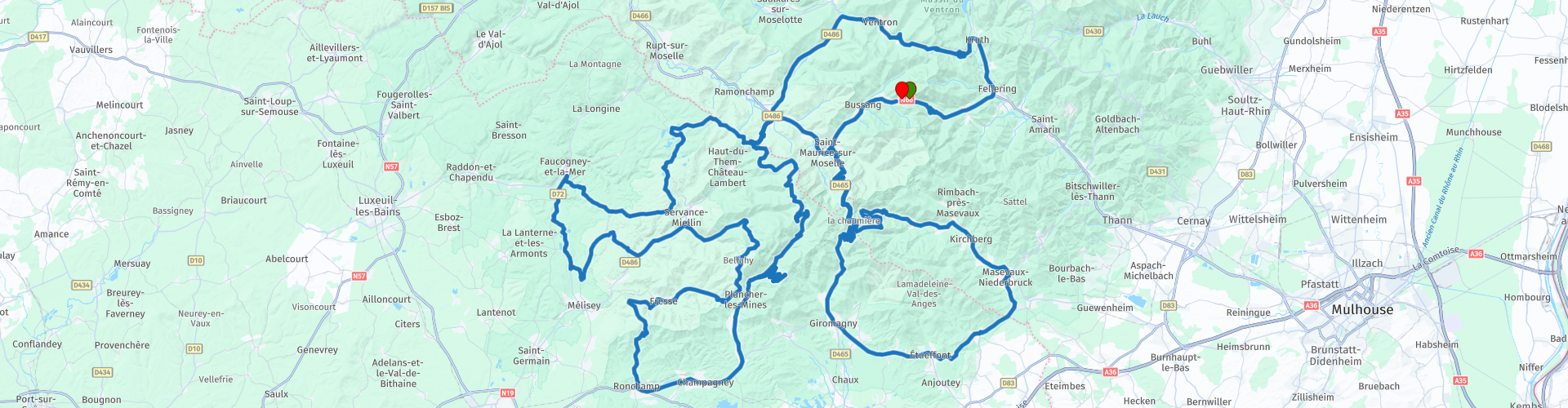
 Start and End Point: Urbès, Moto-Hotel du Col de Bussang
The route is equalized for Garmin, TomTom and MRA Navigation.
Bon voyage.
 Share this route


Animation

Verdict


Duration
7h 53m

Mode of travel
Car or motorcycle

Distance
266.60 km

Countries

 RouteXpert Review
 The High Vosges, and in particular the Ballon d'Alsace, with its 1,165 meters, the highest peak in this route. This tour, actually 3 loops with Le Thillot, where the three valleys meet, is an important commercial crossroads, with its traditional shops, copper mines and 4 supermarkets for its 3,500 inhabitants. But the thousand lakes region, a plateau at the foot of the High Vosges, is also bordered by the rivers Breuchin and Ognon. It is a unique area, formed in the ice ages, of which it still bears many traces, such as the many moraines, boulders and glacier tracks in the rocks. An area characterized by water, mysterious forests, swamps and bogs. From the Middle Ages onwards, marshes have been reclaimed and many lakes have been created. Traditionally, the region has been characterized by small-scale farms, each of which was isolated and scattered throughout the area.
In the heart of the thousand lakes area, hidden in a small idyllic valley, there is an old water mill with accompanying farm and some outbuildings. There used to be numerous water mills in this wetland area. Moulin Begeot, one of the few mills still preserved, is a typical example. The mill dates from 1765 and was enlarged in 1832. The mill was a small economic center for the region: grain was ground, nuts and seeds were pressed into oil, apples were made into cider. A nice place to stop for a look at the mill and have a cup of coffee. You will also visit a winter sports area, which is used for numerous outdoor activities in the summer. You can also eat and drink something in the on-site restaurant. Before you start the 3rd loop, you will pass the town of Saint-Maurice-sur-Moselle, where you can also stop for the inner man.
Most of this 5 star rated, 3 loop route, goes through green hilly area with 5 cols, including the 1,165 meter high Ballon d'Alsace, again plenty of fun with a capital G! Wedeom pay attention because there are again some tough hairpin bends in the route.


 Links
Links  Usage
Usage Want to download this route?
You can download the route for free without MyRoute-app account. To do so, open the route and click 'save as'. Want to edit this route?
No problem, start by opening the route. Follow the tutorial and create your personal MyRoute-app account. After registration, your trial starts automatically.  Disclaimer
Use of this GPS route is at your own expense and risk. The route has been carefully composed and checked by a MyRoute-app accredited RouteXpert for use on TomTom, Garmin and MyRoute-app Navigation.
Changes may nevertheless have occurred due to changed circumstances, road diversions or seasonal closures. We therefore recommend checking each route before use.
Preferably use the route track in your navigation system. More information about the use of MyRoute-app can be found on the website under 'Community' or 'Academy'.

Grand Est
About this region
Grand Est (French: [ɡʁɑ̃t‿ɛst] (listen); Alsatian: Grossa Oschta; Moselle Franconian/Luxembourgish: Grouss Osten;
Rhine Franconian: Groß Oschte; German: Großer Osten [ˈɡʁoːsɐ ˈʔɔstn̩]; English: "Greater East") is an administrative region in Northeastern France. It superseded three former administrative regions, Alsace, Champagne-Ardenne and Lorraine, on 1 January 2016 under the provisional name of Alsace-Champagne-Ardenne-Lorraine (pronounced [alzas ʃɑ̃paɲ aʁdɛn lɔʁɛn]; ACAL or, less commonly, ALCA), as a result of territorial reform which had been passed by the French Parliament in 2014.The region sits astride three water basins (Seine, Meuse and Rhine), spanning an area of 57,433 km2 (22,175 sq mi), the fifth largest in France; it includes two mountain ranges (Vosges and Ardennes). It shares borders with Belgium, Luxembourg, Germany and Switzerland. As of 2017, it had a population of 5,549,586 inhabitants. The prefecture and largest city, by far, is Strasbourg.
The East of France has a rich and diverse culture, being situated at a crossroads between the Latin and Germanic worlds. This history is reflected in the variety of languages spoken there (Alsatian, Champenois, and Lorraine Franconian). Most of today's Grand Est region was considered "Eastern" as early as the 8th century, when it constituted the southern part of the Francian territory of Austrasia. The city of Reims (in Champagne), where Frankish king Clovis I had been baptized in 496 AD, would later play a prominent ceremonial role in French monarchical history as the traditional site of the coronation of the kings of France. The Champagne fairs played a significant role in the economy of medieval Europe as well. Alsace and Lorraine thrived in the sphere of influence of the Holy Roman Empire for most of the Middle Ages and Renaissance, and subject to competing claims by France and German over the centuries.
The region has distinctive traditions such as the celebration of Saint Nicholas Day, Christmas markets, or traditions involving the Easter hare in Alsace and Lorraine. Alsace-Moselle are furthermore subject to local law for historical reasons. With a long industrial history and strong agriculture and tourism (arts, gastronomy, sightseeing), the East of France is one of the top economic producing regions in the country.
Read more on Wikipedia
Rhine Franconian: Groß Oschte; German: Großer Osten [ˈɡʁoːsɐ ˈʔɔstn̩]; English: "Greater East") is an administrative region in Northeastern France. It superseded three former administrative regions, Alsace, Champagne-Ardenne and Lorraine, on 1 January 2016 under the provisional name of Alsace-Champagne-Ardenne-Lorraine (pronounced [alzas ʃɑ̃paɲ aʁdɛn lɔʁɛn]; ACAL or, less commonly, ALCA), as a result of territorial reform which had been passed by the French Parliament in 2014.The region sits astride three water basins (Seine, Meuse and Rhine), spanning an area of 57,433 km2 (22,175 sq mi), the fifth largest in France; it includes two mountain ranges (Vosges and Ardennes). It shares borders with Belgium, Luxembourg, Germany and Switzerland. As of 2017, it had a population of 5,549,586 inhabitants. The prefecture and largest city, by far, is Strasbourg.
The East of France has a rich and diverse culture, being situated at a crossroads between the Latin and Germanic worlds. This history is reflected in the variety of languages spoken there (Alsatian, Champenois, and Lorraine Franconian). Most of today's Grand Est region was considered "Eastern" as early as the 8th century, when it constituted the southern part of the Francian territory of Austrasia. The city of Reims (in Champagne), where Frankish king Clovis I had been baptized in 496 AD, would later play a prominent ceremonial role in French monarchical history as the traditional site of the coronation of the kings of France. The Champagne fairs played a significant role in the economy of medieval Europe as well. Alsace and Lorraine thrived in the sphere of influence of the Holy Roman Empire for most of the Middle Ages and Renaissance, and subject to competing claims by France and German over the centuries.
The region has distinctive traditions such as the celebration of Saint Nicholas Day, Christmas markets, or traditions involving the Easter hare in Alsace and Lorraine. Alsace-Moselle are furthermore subject to local law for historical reasons. With a long industrial history and strong agriculture and tourism (arts, gastronomy, sightseeing), the East of France is one of the top economic producing regions in the country.
View region
 Statistics
  75
75Amount of RX reviews (Grand Est)
 33742
33742Amount of visitors (Grand Est)
 11190
11190Amount of downloads (Grand Est)
 Route Collections in this region
 25 Magnificent trails in France
This MRA route collection contains 25 beautiful motorcycle routes in different parts of France, such as the Ardennes, the Alsace, Vercors, the Drôme, the Ardèche, Cote d'Azure, Gorges du Verdon, the Ariège, the Dordogne and Brittany.
The routes have been carefully created by Bert Loorbach, who is an enthusiastic motorcyclist himself. He lived in France for a year and a half, during which time he devoted himself to mapping the unknown and beautiful back roads of France especially for motorcyclists.
The routes are bundled in the Motortourgids France part 1 of Kosmos publishing house and now also available in MyRouteApp.
I have taken over the routes in MRA and sometimes adjusted them slightly to make them even more interesting for the motorcyclist.
View Route Collection
11 day trip from the Netherlands
8 countries in 11 days; The Netherlands, Germany, Austria, Italy, Switzerland, France, Luxembourg and Belgium. This route collections consists of 10 routes that I have driven with friends in the summer of 2019.
The start is in Geldermalsen Netherlands, the first 7 days you drive through the Netherlands, Germany, Austria, Italy, Switzerland, France and a piece of Luxembourg with overnight stays in hotels.
The last three days you stay in Barweiler (D) in the Eifel and you drive two beautiful tours through the Eifel, Luxembourg and parts of the Belgian Ardennes.
There is no highway in the routes, only beautiful provincial and country roads, many beautiful passes with beautiful panoramas.
Be sure to check whether the passes are open before you leave.
These are routes for experienced drivers.
View Route Collection