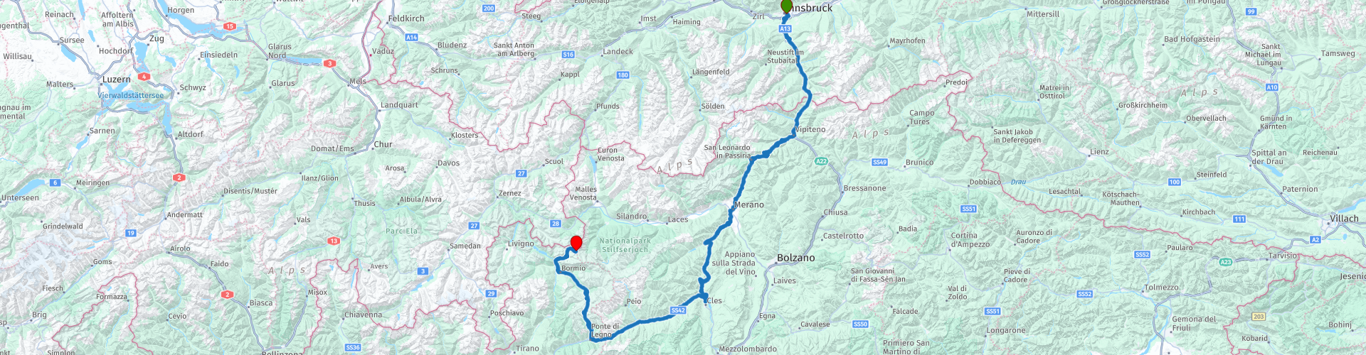
R01 - Innsbruck to Stelvio

This route was brought to you by:
RouteXpert Arno van Lochem - Senior RX
Last edit: 20-10-2022
 Route Summary
 The start of this route is at the loading dock of the OEBB, the Östereiche Bahn. From this point you drive directly into the paradise for the motorcyclist: The Alps.
This route includes the Gavia and Stelvio Pass, two wonderful passes in the Alps. The end point is on top of the latter, at Hotel Genziana.
The route is for the more advanced motorcyclist. Certainly the Stelvio pass and the Gavia require good engine management given the many (tight!) Hairpin bends.
 Share this route


Animation

Verdict


Duration
6h 22m

Mode of travel
Car or motorcycle

Distance
289.09 km

Countries


 RouteXpert Review
 The route starts in Innsbrück at the loading dock of the OEBB. Daily car trains leave from Düsseldorf and have this place in the south of Austria as their terminus. You can also reserve a place for the motorcycle on this night train. Leave in the evening and arrive the next morning rested. For more information about this see the link below.
In Innsbruck the route almost immediately passes a petrol station. Gasoline prices in Austria are considerably lower than in the Netherlands, so it is wise to refuel here.
Despite the fact that Innsbruck is a fairly large city with 130,000 inhabitants, you are already out of the built-up area after 3 kilometers. To the left and right you can already see the hilltops looming, that is still very promising! And indeed, after 4 kilometers the first hairpin bend in front of the wheels, great! The first 40 kilometers you wind parallel to the A13, also known as the Brenner Autobahn, towards the border crossing Austria - Italy. Perhaps nice to stop at the border crossing, there is quite something to see, such as an Outlet Center.
After leaving the Brenner, you drive at Sterzing - Vipiteno onto the SS44, which runs towards the Passo Giovo / Jaufenpass. On top of this 2094m high pass it is time for today's first coffee stop. While you enjoy your coffee you have a fantastic view of the beautiful surroundings.
In the descent of the Jaufenpass you come almost at the bottom past a viewpoint which gives you a beautiful view over St. Leonhard in Passeier. This town is centrally located between the Jaufenpass, the Timmelsjoch and, on the southern side, the route towards the Gavia and Stelvio. All known passes that attract a lot of tourists.
The Passeier Museum is located just south of St. Leonhard in Passeier. This museum gives you a picture of how people used to live in this valley through an outdoor exhibition. The open-air exhibition is an ideal place to spend some time. Here you will find a farm that is typical of the old Passeier valley. In addition to the farm and barn, there are numerous other structures: a mill, blacksmith shop, baking oven, grain store, a lead production place and a beehive. They were all threatened with demolition and have now been faithfully recreated on the open-air site. See link below for more information.
Continue along the SS44, through the Passeier valley, you arrive at Merano. From this place you have the option to follow the SS38 towards the Stelvio, you then follow the climb that starts at Prato. However, this route follows the SS238 towards Lana. From here you follow the SP9 towards Sankt Pankraz. Just outside Lana you will pass a viewpoint Greiter Ried which offers you a nice view over Lana. Definitely worth a break for a nice photo.
After more than 10 kilometers you turn left onto the SP88 towards the Hofmahdjoch - Passo Castrin with an altitude of 1781m. A few kilometers after this pass you come to Lago di Santa Giustina. The lake is located in the center of Val di Non, near Cles. The lake was originally artificial and was formed thanks to the creation of the imposing dyke built between 1943 and 1951. This artificial lake is very impressive and fits perfectly into the landscape of the valley. It is the largest in the province and aims to collect water from the rain basin of the Noce stream to generate electricity. The lake has a total volume of 182 million cubic meters of water and extends for a length of 8 kilometers with a maximum width of one kilometer.
Just before the bridge over this lake is a small parking lot where the motorbike can be parked. On foot up the bridge for a great view over this lake, which of course must be taken a picture.
The route continues on the SS42 which will take you via the Passo Tonale (1842m) towards the ascent of the penultimate pass of this route, the Gaviapass with an altitude of 2621 meters. After the Passo Tonale, this climb starts at Ponte di Legno. The Gavia is a beautiful pass, but if you have a fear of heights it can get exciting in some parts. Sometimes very narrow and if a guardrail is missing it is best to squeeze your buttocks. But the views you get are phenomenal. Take the time to experience this pass, behind every turn a new spectacular view awaits. Lots of photo opportunities!
After the Gavia you arrive in Bormio. The connoisseur knows that the southern side of the Stelvio starts / ends in Bormio. The Stelvio is, as the name of the route says, the end point of this route. The last gas station of this route is located in Bormio. It may be wise to fill up here when the stock of petrol is no longer too large. The next gas station is at least 40 kilometers away.
The climb of the Stelvio is one to remember. From the first meter it is straightforward to climb. After more than 25 hairpin bends and great views you are finally at the top. The same applies here: take your time and enjoy every meter!
At the top, at least when the weather is good, it is very busy. Restaurants, souvenir shops, terraces, the famous sellers of sausage sandwiches with Sauerkraut, great, what a party.
The hotel where the route ends is located in the middle of this party, hotel Genziana. To be honest, it is not the cheapest hotel to stay in, but an experience not to be missed. In the evening the ascent to the viewpoint 'Dreisprachenspitze' at almost 2850 meters, the beautiful sunrise the next morning, moments that really make it worthwhile to experience this once.
Have fun driving this route!


 Links
Links  Usage
Usage Want to download this route?
You can download the route for free without MyRoute-app account. To do so, open the route and click 'save as'. Want to edit this route?
No problem, start by opening the route. Follow the tutorial and create your personal MyRoute-app account. After registration, your trial starts automatically.  Disclaimer
Use of this GPS route is at your own expense and risk. The route has been carefully composed and checked by a MyRoute-app accredited RouteXpert for use on TomTom, Garmin and MyRoute-app Navigation.
Changes may nevertheless have occurred due to changed circumstances, road diversions or seasonal closures. We therefore recommend checking each route before use.
Preferably use the route track in your navigation system. More information about the use of MyRoute-app can be found on the website under 'Community' or 'Academy'.

Tyrol
About this region
Tyrol (; German: Tirol [tiˈʁoːl] (listen); Italian: Tirolo) is a state (Land) in western Austria. It comprises the Austrian part of the historical Princely County of Tyrol. It is a constituent part of the present-day Euroregion Tyrol–South Tyrol–Trentino (together with South Tyrol and Trentino in Italy). The capital of Tyrol is Innsbruck.
Read more on Wikipedia
View region
 Statistics
  35
35Amount of RX reviews (Tyrol)
 44781
44781Amount of visitors (Tyrol)
 5506
5506Amount of downloads (Tyrol)
 Route Collections in this region
 The 24 Most Beautiful Alpine Routes
The Alps, The Alps are a mountain range in Europe, stretching from the French Mediterranean coast in the southwest to the Pannonian Plain in the east. The area of the mountain range is more than 200,000 km².
In other words Passes and Mountain Roads!
Driving through the mountains is great! Especially over the mountain passes with hairpin bends and narrow winding roads. Every bend a different view where you can enjoy. There are many beautiful mountain passes in the Alps.
A selection that has also been incorporated into these routes:
The Stlevio Pass:
The Stelvio Pass, also known as Passo dello Stelvio, is mainly known for the stage in the Giro d'Italia. Due to the length and the difference in height, this pass is seen as one of the toughest tests in cycling. The Stelvio Pass reaches a maximum height of 2758 meters and is therefore one of the highest in the Alps. The pass connects the towns of Bormio and Prato Allo Stelvio. In winter the pass is closed due to heavy snowfall.
The Reschenpass:
The Reschenpass, also known as Passo di Resia, connects the Austrian state of Tyrol with the Italian province of South Tyrol. The pass reaches a maximum height of 1,504 meters and has been one of the most important north-south connections in the Alps in recent centuries. The pass was used long before Roman times. Along the way you will pass several highlights and historical relics. One of the highlights is the Reschensee. This lake was created after the construction of the dam and has completely submerged the village of Graun. The only thing that reminds of that is the clock tower in the middle of the lake.
Col du Galibier:
The French mountain pass Col du Galibier connects the towns of Saint-Michel-de-Maurienne and Briançon via the Col du Lautaret in the south and the Col du Télégraphe in the north. The mountain pass is part of the Tour de France and very much feared, due to the fact that it can only be reached via the other two mountain passes. The pass reaches a maximum height of 2646 meters. From there you can take a walk to the viewpoint at 2704 meters. You can admire the peaks of the Grand Galibier, Mont Blanc and La Meije here.
The Grossglockner High Alpine Road:
With a height of 3798 meters the Grossglockner is the highest mountain in Austria. To fully enjoy this impressive mountain, you can drive over the Grossglockner High Alpine Road and the accompanying pass. The route starts from Bruck am Grossglockner and ends in Heiligenblut. Of course you can drive in two directions. The pass reaches a maximum height of 2504 meters and is closed in winter due to heavy snowfall. Along the way you pass several stops with fun activities, information points, mountain huts and viewpoints. A visit to the Kaiser-Franz-Josefs-Höhe and Pasterzen Glacier is highly recommended.
The Col d'Izoard:
Just like the Col du Galibier, the Col d'Izoard is also part of a stage of the Tour de France. The mountain pass connects Briançon with the valley of the river Guil. The pass is partly located in the Regional Natural Park du Queyras and reaches a maximum height of 2360 meters. What is special about the Col d'Izoard is the barren and rocky landscape. Sometimes it feels like driving a car over the moon! Along the way you can stop at several points to enjoy the beautiful view.
The Bernina Pass:
The Bernina Express is one of the most famous rail trains in Switzerland and the Alps. The route is beautiful and partly included on the UNESCO World Heritage List. Parallel to the railway lies the Bernina pass, which connects the Veltlin valley with the Egandin valley. This beautiful Alpine road has a total length of 56 kilometers and reaches a maximum height of 2328 meters. Along the way you can enjoy views of the Morteratsch Glacier.
The Sella Pass:
The Sella Pass, also known as Passo di Sella, takes you over one of the most impressive mountain ranges in the Dolomites: the Sella massif. The pass connects Valle di Fassa with Val Gardena and reaches a maximum height of 2236 meters. At this height is also the border of the Italian provinces of Trentino and Bolzano. Along the way you can enjoy the view of this spectacular mountain world. Admire, for example, the three peaks of the Sasso Lungo massif, the Sella massif or the peaks of the Marmolada. You can also drive the Sella pass in combination with the Gardena pass, Pordoi pass and Campolongo pass.
The Grimsel Pass:
The Grimsel Pass connects Goms in Wallis with the Halis Valley in the Bernese Oberland. The pass reaches a maximum elevation of 2165 meters and is closed in winter due to snowfall. Over the centuries, the mountain pass has played an important role in trade between Switzerland and Italy. Now it is mainly the reservoirs that have an important function. These are used to generate electricity. The landscape you drive through is rugged, rocky and impressive. On top of the pass is a hotel and a restaurant with a special marmot park. The Dodensee (Totensee) is also located here. This lake owes its name to the many soldiers who died in the time of Napoleon.
The Gotthard Pass:
The Gotthard Pass, also known as Passo del San Gottardo and Saint Gotthard, connects the Swiss towns of Airolo and Andermatt. The mountain pass and associated tunnel are especially known among holidaymakers driving from Switzerland to Italy. But where the majority opt for the tunnel, it is precisely the pass that really completes the holiday. The Gotthard Pass has a length of about 26 kilometers and reaches a maximum height of 2106 meters. The route is beautiful and takes you along old villages and beautiful views.
The Silvretta High Alpine Road and Silvretta Pass:
The Paznaun Valley in Tyrol and the Montafon in Vorarlberg are connected by the Silvretta High Alpine Road. The route has a length of 22.3 kilometers and leads from Galtür to Partenen in 34 hairpin bends, via the 2032 meter high Bielerhöhe. The Silvrettasee is also located at this point, where you can enjoy a lovely walk. The pass is closed in winter due to snowfall.
The Simplon Pass:
Just like the Gotthard Pass, many holidaymakers also travel over the Simplon Pass every year. This mountain pass connects the Rhone Valley in the canton of Valais with the Valle d'Ossola in Piemonte. The pass is open all year round and reaches a maximum height of 2005 meters. Along the way you pass a number of buildings, including the well-known Simplon Hospiz from 1825. The hospiz is managed by the monks of St. Bernard. From the highest point on the pass, all kinds of hiking routes are possible and you will also come across a hotel where you can spend the night.
The Gerlos Pass:
The Gerlos Pass connects the Salzach Valley in the Salzburgerland with the Zillertal Valley in Tyrol. The pass is part of the Gerlos Alpenstraße and runs right through the Hohe Tauern National Park. Along the way you can enjoy beautiful views of the surroundings. The pass has a length of 12 kilometers and reaches a maximum height of 1531 meters. A ride over the Gerlos Pass can be ideally combined with a visit to the Krimmler Wasserfälle.
The Great St. Bernard Pass:
The Great St. Bernard Pass, better known as Col du Grand Saint Bernard, connects the Italian province of Valle d'Aosta with the Swiss canton of Valais. The pass is one of the highest in Switzerland and reaches a maximum height of 2469 meters. Like a number of other mountain passes in this list, the Great St. Bernard Pass has also been used as a connecting road for centuries. The pass is named after the St. Bernard dogs that used to help stranded travelers along with the monks. The pass is closed in winter.
The Timmelsjoch High Alpine Road:
The Timmelsjoch High Alpine Road connects the towns of Sölden in the Ötztal and Meran in South Tyrol. Tolls must be paid on the Hochgurgl - Moos route. Via a mountain road with about 60 hairpin bends you drive through a beautiful mountain world. With the Timmelsjoch Experience you can learn more about the history, the road and the environment via various stations. You can also visit the Top Mountain Crosspoint museum.
Col de l'Iseran:
With a maximum pass height of 2770 meters, the Col l'Iséran is one of the highest mountain passes in the Alps. The pass connects Bourg-Saint-Maurice with Bonneval-sur-Arc. Via a road full of hairpin bends you pass, among other things, Val-d'Isère and a side valley of the Maurienne that lies entirely in the National Park de la Vanoise. You can spot animals such as marmots and chamois and there is also a restaurant with a chapel on top of the pass.
The Gavia Pass:
The Gavia Pass (Italian Passo di Gavia) is a mountain pass in the Italian Alps, in the Lombardy region.
It is one of the highest pass roads in Europe. The road leads through the unspoilt Stelvio National Park. The road was built in the First World War to supply Italian soldiers who fought in the Italian-Austrian border area. The pass height is one of the most beautiful in the Alps. Here is the large Lago Bianco with, to the north, the mountain San Matteo (3684 meters). Lago Nero is slightly lower on the south side of the pass. Here the mountain group of the Adamello determines the view. There are many well-marked walks in the area. During the winter the pass is closed due to the heavy snowfall. The pass is often closed until May and June due to the large amount of snow.
Promoter has made a selection of the 24 Most Beautiful Alpine routes that they have set out in recent years.
The routes go through:
France
Austria
Switzerland
Italy
The most beautiful roads, the most beautiful views, the most beautiful viewpoints. The highest mountains, the fastest descents, hairpin bend after hairpin bend, you name it you can't get enough of it.
If you go on holiday in this region, take advantage of it, ALL routes in this collection have been checked and made equal for TomTom, Garmin and MyRoute-app Navigation by a MyRoute-app RouteXpert.
Have fun with this collection and while driving one of these routes. Enjoy all the beauty that the Alps and the Dolomites have to offer. Click on “View route” to read the review of the chosen route.
I would like to hear your findings about the route(s).
View Route Collection
The 12 most beautiful car and motorcycle routes in Carinthia
“Motorradland Kärnten” where you feel so wonderfully welcome as a motorcyclist!
Own website for motorcyclists, own curated routes, hotels, campsites and guest houses with attention for motorcyclists, a wonderful area where motorcyclists are very popular.
Kärnten or Carinthia, at the crossroads of the Germanic, Slavic and Roman worlds. Three cultures within a few kilometres, southern flair, culinary delights, cross-border tours. Breakfast in Italy, lunch in Slovenia, dinner in Austria - all in one day. Experience the diversity in the borderless Alps-Adriatic region, the area for motorcyclists.
Extensive day trips on winding mountain paths, romantic panoramic routes and beautiful lakes, here the 12 TOP routes Kärnten / Carinthia. Enjoy!
View Route Collection