R04 - Sisikon to Rickenbach

This route was brought to you by:
RouteXpert Arno van Lochem - Senior RX
Last edit: 26-01-2021
 Route Summary
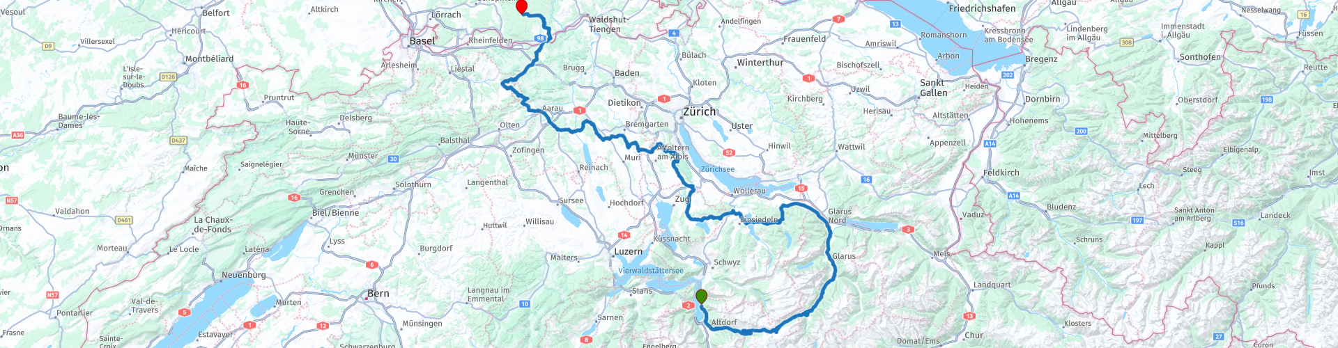
 The start of this route is at hotel Tellsplatte on Lake Lucerne. Via the Klausen Pass and a number of smaller passes such as the Sattelegg and the Raten you drive through beautiful Switzerland. The end point of this route is in the Black Forest in the German town of Rickenbach at Hotel Engel.
The route is for the more advanced motorcyclist given the occasional tight hairpin bends in the Alps. Good engine management is desired!
 Share this route


Animation

Verdict


Duration
7h 56m

Mode of travel
Car or motorcycle

Distance
272.66 km

Countries


 RouteXpert Review
 The route starts at the Hotel Tellsplatte on the wonderfully beautiful Vierwaldstätter See. The first part you drive along the water, every now and then the beautiful view is interrupted by a tunnel. In Burglen you follow the route towards the Klausenpass, which is quickly reached. After driving well and 10 kilometers you will find yourself again between the green meadows between which the asphalt is beautifully curly laid out. Wherever you look, it is a joy to see. Switzerland at its best.
The Klausenpass is traditionally not as important as other mountain passes, although it is the only one in the region. In 1899 the pass road was opened, which was later little modified, only repaved. Most of the pass road is quite narrow. Due to the high costs, the Klausenpass is closed in winter. Because it is difficult to combine with other mountain passes, the Klausenpass is not as popular as the Furkapass or Grimselpass, for example. However, that doesn't make it any less beautiful.
The climb to the top of the Klausen Pass is accompanied by great views of green valleys and snow-capped peaks. Once at the top you have a beautiful view of the road you have just traveled. Definitely take a picture!
After the last hairpin bend of the Klausen Pass you meander through the valley towards Mollis and Oberurnen. In the latter place it is time for a well-deserved cup of coffee. From the elevated terrace of this establishment you have a pleasant view while enjoying your coffee.
After coffee, you will swing for a while on the road with number 3 and then turn left in Schübelbach to start the ascent of the Sattelegg, a pass with a pass height of 1190 meters. Despite this low altitude, there is still a winter sports area on top of this pass. With no less than 1 kilometer and 1 lift. But still, with snow you can get on the skis. Hopefully you will not see snow while driving this route and you can enjoy the beauty that this pass has to offer. These are wonderful curves in addition to the beautiful green landscape! A few hairpin bends at the start and nice twists.
At the bottom of the Sattelegg descent you come to Sihlsee, an artificial lake created by damming the Sihl River and flooding part of the upper Sihl Valley. The lake is the largest artificial lake in Switzerland in terms of surface area with a maximum length of 8.5 kilometers and a maximum width of 2.5 kilometers. The maximum depth is 17 meters and it has an estimated volume of 96,000,000 m3.
The route runs from the Sihlsee towards the Ratenpas, a pass with a height of 1077 meters. The pass has some great curves that you can pass quite quickly, the pass has a length of about 9 kilometers. Not a spectacular distance, but the incredibly smooth asphalt and the view over the green pastures more than makes up for that.
At the bottom of the descent you have arrived at Lake Ägerisee, a lake of 7.2 km². The main influx is the Hüribach, the outflow is the Lorze. The Ägerisee has been used as a drinking water reservoir since 1992. Water from the lake is still used for this.
After you have left the Ägerisee behind you, you have the opportunity to visit the local stalactite caves in the Lorze valley near Baar. The caves of Höllgrotten are unlike any other stalactite caves in the world. While other caves were carved out of bedrock by underground watercourses in a process of millions of years, the Höllgrotten Caves were formed on the surface in a relatively short period of about 3000 years, making them relatively "young". Definitely worth a visit!
After the underground natural beauty, it is high time to take care of the inner man. This is easy to do at Restaurant Buchenegg, located in a beautiful location with a large outdoor terrace from which you have a great view over the valley below. Just walk to the edge of the terrace. Don't forget the photo camera!
The route continues meandering through the wonderfully beautiful surroundings. Then again beautiful green meadows where you drive in between, then pieces of forest that seem to never end. You drive unnoticed towards the German border.
However, before you reach the border with Germany, the Salhöhe pass is first on the route. This is the last Swiss pass in this route and has a pass height of 779 meters. However, the road over it is to feast on and now and then you really see that you are driving at height. The road will treat you to a series of great turns!
On top of the pass, there is a great opportunity for a short break to enjoy a cup of coffee or another drink.
Also in the descent you can enjoy the winding asphalt and the beautiful views that you get to see. The winding continues until Laufenburg where you cross the Rhine, leaving Switzerland behind. The beautiful Swiss country is exchanged for another great region: The Black Forest. Here too it is wonderful to steer and not unimportant: The police keep the coupon book in the pocket for 20 km / h longer. And if they bring it out, the sanctions are relatively low, especially by Dutch standards.
After the first kilometers through the Black Forest you will arrive at Alemannenhof Hotel Engel in Rickenbach. Great terrace and a hostess who knows how to keep a bunch of motorcyclists happy: Good food and a good pot of beer!
Have fun driving this route!


 Links
Links  Usage
Usage Want to download this route?
You can download the route for free without MyRoute-app account. To do so, open the route and click 'save as'. Want to edit this route?
No problem, start by opening the route. Follow the tutorial and create your personal MyRoute-app account. After registration, your trial starts automatically.  Disclaimer
Use of this GPS route is at your own expense and risk. The route has been carefully composed and checked by a MyRoute-app accredited RouteXpert for use on TomTom, Garmin and MyRoute-app Navigation.
Changes may nevertheless have occurred due to changed circumstances, road diversions or seasonal closures. We therefore recommend checking each route before use.
Preferably use the route track in your navigation system. More information about the use of MyRoute-app can be found on the website under 'Community' or 'Academy'.

Baden-Württemberg
About this region
Baden-Württemberg (; German: [ˌbaːdn̩ ˈvʏʁtəmbɛʁk] (listen)), commonly shortened to BW or BaWü, is a German state (Bundesland) in Southwest Germany, east of the Rhine, which forms the southern part of Germany's western border with France. With more than 11.07 million inhabitants as of 2019 across a total area of nearly 35,752 km2 (13,804 sq mi), it is the third-largest German state by both area (behind Bavaria and Lower Saxony) and population (behind North Rhine-Westphalia and Bavaria). As a federated state, Baden-Württemberg is a partly-sovereign parliamentary republic. The largest city in Baden-Württemberg is the state capital of Stuttgart, followed by Mannheim and Karlsruhe. Other major cities are Freiburg im Breisgau, Heidelberg, Heilbronn, Pforzheim, Reutlingen, Tübingen, and Ulm.
What is now Baden-Württemberg was formerly the historical territories of Baden, Prussian Hohenzollern, and Württemberg. Baden-Württemberg became a state of West Germany in April 1952 by the merger of Württemberg-Baden, South Baden, and Württemberg-Hohenzollern. These states had just been artificially created by the Allies after World War II out of the existing traditional states Baden and Württemberg by their separation over different occupation zones.
Baden-Württemberg is especially known for its strong economy with various industries like car manufacturing, electrical engineering, mechanical engineering, the service sector, and more. It has the third highest gross regional product (GRP) in Germany. Part of the Four Motors for Europe, some of the largest German companies are headquartered in Baden-Württemberg, including Daimler, Porsche, Bosch and SAP.
The sobriquet Ländle (a diminutive of the word "Land" in the local Swabian, Alemannic and Franconian dialects) is sometimes used as a synonym for Baden-Württemberg.
Read more on Wikipedia
What is now Baden-Württemberg was formerly the historical territories of Baden, Prussian Hohenzollern, and Württemberg. Baden-Württemberg became a state of West Germany in April 1952 by the merger of Württemberg-Baden, South Baden, and Württemberg-Hohenzollern. These states had just been artificially created by the Allies after World War II out of the existing traditional states Baden and Württemberg by their separation over different occupation zones.
Baden-Württemberg is especially known for its strong economy with various industries like car manufacturing, electrical engineering, mechanical engineering, the service sector, and more. It has the third highest gross regional product (GRP) in Germany. Part of the Four Motors for Europe, some of the largest German companies are headquartered in Baden-Württemberg, including Daimler, Porsche, Bosch and SAP.
The sobriquet Ländle (a diminutive of the word "Land" in the local Swabian, Alemannic and Franconian dialects) is sometimes used as a synonym for Baden-Württemberg.
View region
 Statistics
  58
58Amount of RX reviews (Baden-Württemberg)
 40825
40825Amount of visitors (Baden-Württemberg)
 9656
9656Amount of downloads (Baden-Württemberg)
 Route Collections in this region
 Top 5 Car and Motorcycle Routes in the Black Forest
The Black Forest, who hasn't heard of it? The Black Forest is a densely forested area and low mountain range in southwestern Germany, located in the state of Baden-Württemberg, on the Rhine and the French border. It is the largest low mountain range in Germany. Geologically, it is related to the Vosges Mountains, which lie on the French side of the Rhine. The highest peak of the Black Forest is the Feldberg with a height of 1493 meters above sea level. The Black Forest is the largest forest area in Germany and consists mainly of pine and spruce trees. The Black Forest is known as one of the most popular tourist destinations in Germany. A small part in the north is protected as the Schwarzwald National Park. The Romans called the densely forested mountain range with its distinctive dark conifers Silva Nigra - "the Black or Dark Forest or impenetrable forest", which to them was ominous and almost impenetrable. The German word Schwarzwald was used for the first time in a document from the Swiss monastery of St. Gallen from the year 868. A well-known car route is the Schwarzwald-Hochstraße, B 500 and the Uhrenstraße. The Black Forest is known worldwide for the fairy tales of the Brothers Grimm.
There are also several lakes in the Black Forest, namely: Titisee, Glaswaldsee, Mummelsee, Kirnbergsee, Feldsee, Schluchsee and the Hotzenwald.
The highest peaks in the Black Forest are: Feldberg (1493 m), Seebuck (1448 m), Herzogenhorn (1415 m), Belchen (1414 m), Schauinsland (1284 m), Kandel (1243 m) and the Hornisgrinde (1164 m ).
Reason enough for the MyRoute app RouteXpert to compile a Top 5 of Car and Motorcycle Routes for you.
All routes in this collection have been checked and made equal for TomTom, Garmin and MyRoute-app Navigation by a MyRoute-app RouteXpert.
If you think, I have a very nice route that should certainly not be missing from this collection, send it to:
email: routeexpert@myrouteapp.com
Subject: New Route for the Top 5 collection Black Forest composed by Hans van de Ven.
The route will then be reviewed and then added to the Top 5. To make the Top 5 also the Top 5, 1 route will have to disappear from the Top 5, you can indicate this when submitting the new route.
Have fun with this collection and while driving one of these routes. Enjoy all the beauty that the Black Forest has to offer. Click on “View route” to read the review of the chosen route.
I would like to hear your findings about the route(s).
View Route Collection
11 day trip from the Netherlands
8 countries in 11 days; The Netherlands, Germany, Austria, Italy, Switzerland, France, Luxembourg and Belgium. This route collections consists of 10 routes that I have driven with friends in the summer of 2019.
The start is in Geldermalsen Netherlands, the first 7 days you drive through the Netherlands, Germany, Austria, Italy, Switzerland, France and a piece of Luxembourg with overnight stays in hotels.
The last three days you stay in Barweiler (D) in the Eifel and you drive two beautiful tours through the Eifel, Luxembourg and parts of the Belgian Ardennes.
There is no highway in the routes, only beautiful provincial and country roads, many beautiful passes with beautiful panoramas.
Be sure to check whether the passes are open before you leave.
These are routes for experienced drivers.
View Route Collection