4 From Trafoi to Vigo di Fassa via Stelvio and Gavia

This route was brought to you by:
RouteXpert Guy Heyns - Adv. RouteXpert
Last edit: 10-12-2024
 Route Summary
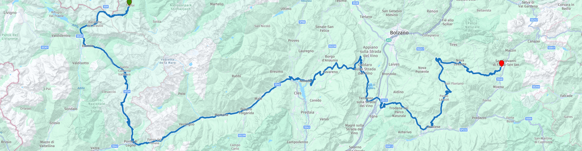
 You ride the famous Stelvio & Gavia, but continue to the Dolomites via the Passo del Tonale, Della Mendola, di San Lugano, di Lavazé and finally the Passo di Costalungo or Karerpass.
The route ends in Vigo di Fassa, in the middle of the Dolomites where you can fully enjoy the beautiful scenery that the surrounding mountains offer.
 Share this route


Animation

Verdict


Duration
8h 7m

Mode of travel
Car or motorcycle

Distance
259.95 km

Countries

 RouteXpert Review
 The moment you leave in Trafoi you are immediately in the right place, at 1 kilometer from the start you will find the first Stelvio pin. Only 44 to go and you are at the top of 2758 meters, one of the highest rideable peaks in Europe. The Col de l'Iseran in France is higher and the Col de la Bonette, also in France, also wants to take the honor, but that's a bit cheating. On the Bonette they have actually added a top to make it the highest road in Europe that can be driven on. The Stelvio (rp2) is in any case also one of the oldest. In 1825 the original road was completed and it was also kept open all year round as it was the main link between Vienna and Milan. Today that is no longer the case and the Stelvio only closes between October and May. Very often also in June, given the snowfall at this height. Even in summer, snow can fall and the pass closes inexorably. Do not underestimate the Stelvio and the rapid follow-up of the hairpin bends.
Fun fact, if you want to refuel at the highest cash machine in Europe, then the top of the Stelvio is also the 'place to be…'.
30 pins in the descent later, you end up in Bormio where you pass on the way to the Gavia. The first petrol station on the route can also be found in Bormio (rp3), if necessary.
The Gavia pass (rp 4) is a fairly long pass that reaches 2621 meters at the top. It is also a fairly steep pass that is sometimes barely 3 meters wide. Immediately in addition, sometimes depths of 500 meters yawn. All this together makes the Gavia actually quite a dangerous pass that must be taken with the necessary caution.
The descent to Ponte di Legno is a nice playground. After Ponto di Legno, it turns in the direction of the Dolomites while the Passo del Tonale (rp 5) and the Passo dela Mendola (rp 7) (Mendelpass) slide under the wheels in the transition from the Alps to the Dolomites.
The Passo del Tonale is normally open all year round. It lies in the middle of a turbulent war zone and the war memorial at the top reminds you of it.
The Mendel Pass, on the other hand, is a bit more touristy and could already receive several famous guests in the past; Gandhi, Röntgen, Franz Joseph I of Austria…, they have all stayed here.
When the weather is clear, the Latemar massif of the Dolomites mountain range can be seen for the first time on the top of the Mendel Pass, but first you descend to the valley of the Adige and then make the winding climb to the Passo di San Lugano. the first Dolomites pass on the route.
The Dolomites basically consist of four massifs which we list in order of arrival on this (and the next) route: The Latemar massif is the first on your right, while the Rosengarten remains on your left. The Marmolada and the Sella are next in the list, but we just don't pass them on this route, since we first visit the sleeping mat in Vigo di Fassa. But before arriving there, a very pleasant course awaits us, which, as already mentioned, starts at the Passo di San Lugano.
The Passo di San Lugano (rp9) is fairly easy to drive. A few pins in the row, but then it goes nice and loose. It is nice to know that the pass, with which you actually enter the massifs of the Dolomites, is named after the holy apostle of the Dolomites, a good, safe and protected start to a stay in the Dolomites.
After Cavalese you start the climb of the Passo di Lavazè. From the entrance of this pass you get a view of the Latemar massif of the Dolomites on your right. The pass is easy to ride with a stronger gradient (12%) at the end. As you drive through the valley, think for a moment of the 20 victims who fell when in 1998 a jet fighter cut the cables of a cable car in its flight through the valley.
The descent of the Lavazèpass not only offers you a view of the Latemar massif, but from now on you also get to see parts of the Rosengarten massif.
After about 15 kilometers in the descent, at San Valentino (rp14), you will find 11 very fast consecutive and very nice pins that take you to the valley that forms the approach to the Karerpass or the Passo di Costalunga (rp18). Here you will see both the Latemar on the right and the Rosengarten on your left. A strongly recommended rest point is certainly route point 17 where you can admire both massifs extensively while enjoying a nice break.
Fun fact is that the Karerpass runs along the Karersee (marked on the map). The very large Latemar massif owes its name to this relatively small lake. After all, Latemar comes from the old Ladin name 'Cresta-de Lac-te-mara', which means 'Mountain ridge above the Karermeer'.
The Rosengarten massif then takes its name from the legend of the dwarf king Laurin. Legend has it that it had a rose garden high up on the mountain that became visible every evening with the last rays of the sun caressing the ridge ...
From the Karer Pass it is then only 9 kilometers to the final destination in Vigo di Fassa, where hotel 'Carpe Diem' (what's in a name?) Awaits you at rp 20. On the way there you are occasionally already a look at the Marmolada, the playground that opens tomorrow.
Despite the transition road between Alps and Dolomites (rp 5 to 6) the route definitely deserves a 5 star rating, and even the transition road is beautiful in itself, although there are few opportunities for a break. But otherwise, the route is sublime in terms of views and technicality. Don't underestimate this route! The Stelvio has very quick successive pins that many a rider has already choked on. And the Gavia is rightly called a dangerous pass because of its very narrow road and deep precipices immediately adjacent to it.
But once you have passed Scanna in the queue to the Mendel, the headline feast really starts! Nice curves, nice climbs, silly long stretches of asphalt and the occasional nasty little squeeze to keep you focused. You don't need more to arrive with a blissful smile in 'Carpe Diem', where you will undoubtedly enjoy a blissful night's sleep. Don't forget to stop on rp 17 to take in the beauty of the Dolomites. And then you have to realize that you have actually only half seen it ... the 'special attractions' of the playground have yet to open ...


 Links
Links  Usage
Usage Want to download this route?
You can download the route for free without MyRoute-app account. To do so, open the route and click 'save as'. Want to edit this route?
No problem, start by opening the route. Follow the tutorial and create your personal MyRoute-app account. After registration, your trial starts automatically.  Disclaimer
Use of this GPS route is at your own expense and risk. The route has been carefully composed and checked by a MyRoute-app accredited RouteXpert for use on TomTom, Garmin and MyRoute-app Navigation.
Changes may nevertheless have occurred due to changed circumstances, road diversions or seasonal closures. We therefore recommend checking each route before use.
Preferably use the route track in your navigation system. More information about the use of MyRoute-app can be found on the website under 'Community' or 'Academy'.

Trentino-Alto Adige/Südtirol
About this region
Trentino-Alto Adige/Südtirol (US: , UK: ; Italian: Trentino-Alto Adige [trenˈtiːno ˈalto ˈaːdidʒe]; German: Trentino-Südtirol; Ladin: Trentin-Südtirol) is an autonomous region of Italy, located in the northern part of the country. The region has a population of 1.1 million, of whom 62% speak Italian as their mother tongue, 30% speak German dialects and several foreign languages are spoken by immigrant communities. Since the 1970s, most legislative and administrative powers have been transferred to the two self-governing provinces that make up the region: the Province of Trento, commonly known as Trentino, and the Province of Bolzano, commonly known as South Tyrol (Alto Adige in Italian).
From the 9th century until 1801, the region was part of the Holy Roman Empire. After being part of the short-lived Napoleonic Republic of Italy and Napoleonic Kingdom of Italy, the region was part of the Austrian Empire and its successor Austria-Hungary from 1815 until its 1919 transfer to Italy in the Treaty of Saint-Germain-en-Laye at the end of World War I. Together with the Austrian state of Tyrol it is represented by the Euroregion Tyrol-South Tyrol-Trentino.
In English, the region is known as Trentino-South Tyrol or by its Italian name Trentino-Alto Adige.
Read more on Wikipedia
From the 9th century until 1801, the region was part of the Holy Roman Empire. After being part of the short-lived Napoleonic Republic of Italy and Napoleonic Kingdom of Italy, the region was part of the Austrian Empire and its successor Austria-Hungary from 1815 until its 1919 transfer to Italy in the Treaty of Saint-Germain-en-Laye at the end of World War I. Together with the Austrian state of Tyrol it is represented by the Euroregion Tyrol-South Tyrol-Trentino.
In English, the region is known as Trentino-South Tyrol or by its Italian name Trentino-Alto Adige.
View region
 Statistics
  53
53Amount of RX reviews (Trentino-Alto Adige/Südtirol)
 37771
37771Amount of visitors (Trentino-Alto Adige/Südtirol)
 7747
7747Amount of downloads (Trentino-Alto Adige/Südtirol)
 Route Collections in this region
 The 24 Most Beautiful Alpine Routes
The Alps, The Alps are a mountain range in Europe, stretching from the French Mediterranean coast in the southwest to the Pannonian Plain in the east. The area of the mountain range is more than 200,000 km².
In other words Passes and Mountain Roads!
Driving through the mountains is great! Especially over the mountain passes with hairpin bends and narrow winding roads. Every bend a different view where you can enjoy. There are many beautiful mountain passes in the Alps.
A selection that has also been incorporated into these routes:
The Stlevio Pass:
The Stelvio Pass, also known as Passo dello Stelvio, is mainly known for the stage in the Giro d'Italia. Due to the length and the difference in height, this pass is seen as one of the toughest tests in cycling. The Stelvio Pass reaches a maximum height of 2758 meters and is therefore one of the highest in the Alps. The pass connects the towns of Bormio and Prato Allo Stelvio. In winter the pass is closed due to heavy snowfall.
The Reschenpass:
The Reschenpass, also known as Passo di Resia, connects the Austrian state of Tyrol with the Italian province of South Tyrol. The pass reaches a maximum height of 1,504 meters and has been one of the most important north-south connections in the Alps in recent centuries. The pass was used long before Roman times. Along the way you will pass several highlights and historical relics. One of the highlights is the Reschensee. This lake was created after the construction of the dam and has completely submerged the village of Graun. The only thing that reminds of that is the clock tower in the middle of the lake.
Col du Galibier:
The French mountain pass Col du Galibier connects the towns of Saint-Michel-de-Maurienne and Briançon via the Col du Lautaret in the south and the Col du Télégraphe in the north. The mountain pass is part of the Tour de France and very much feared, due to the fact that it can only be reached via the other two mountain passes. The pass reaches a maximum height of 2646 meters. From there you can take a walk to the viewpoint at 2704 meters. You can admire the peaks of the Grand Galibier, Mont Blanc and La Meije here.
The Grossglockner High Alpine Road:
With a height of 3798 meters the Grossglockner is the highest mountain in Austria. To fully enjoy this impressive mountain, you can drive over the Grossglockner High Alpine Road and the accompanying pass. The route starts from Bruck am Grossglockner and ends in Heiligenblut. Of course you can drive in two directions. The pass reaches a maximum height of 2504 meters and is closed in winter due to heavy snowfall. Along the way you pass several stops with fun activities, information points, mountain huts and viewpoints. A visit to the Kaiser-Franz-Josefs-Höhe and Pasterzen Glacier is highly recommended.
The Col d'Izoard:
Just like the Col du Galibier, the Col d'Izoard is also part of a stage of the Tour de France. The mountain pass connects Briançon with the valley of the river Guil. The pass is partly located in the Regional Natural Park du Queyras and reaches a maximum height of 2360 meters. What is special about the Col d'Izoard is the barren and rocky landscape. Sometimes it feels like driving a car over the moon! Along the way you can stop at several points to enjoy the beautiful view.
The Bernina Pass:
The Bernina Express is one of the most famous rail trains in Switzerland and the Alps. The route is beautiful and partly included on the UNESCO World Heritage List. Parallel to the railway lies the Bernina pass, which connects the Veltlin valley with the Egandin valley. This beautiful Alpine road has a total length of 56 kilometers and reaches a maximum height of 2328 meters. Along the way you can enjoy views of the Morteratsch Glacier.
The Sella Pass:
The Sella Pass, also known as Passo di Sella, takes you over one of the most impressive mountain ranges in the Dolomites: the Sella massif. The pass connects Valle di Fassa with Val Gardena and reaches a maximum height of 2236 meters. At this height is also the border of the Italian provinces of Trentino and Bolzano. Along the way you can enjoy the view of this spectacular mountain world. Admire, for example, the three peaks of the Sasso Lungo massif, the Sella massif or the peaks of the Marmolada. You can also drive the Sella pass in combination with the Gardena pass, Pordoi pass and Campolongo pass.
The Grimsel Pass:
The Grimsel Pass connects Goms in Wallis with the Halis Valley in the Bernese Oberland. The pass reaches a maximum elevation of 2165 meters and is closed in winter due to snowfall. Over the centuries, the mountain pass has played an important role in trade between Switzerland and Italy. Now it is mainly the reservoirs that have an important function. These are used to generate electricity. The landscape you drive through is rugged, rocky and impressive. On top of the pass is a hotel and a restaurant with a special marmot park. The Dodensee (Totensee) is also located here. This lake owes its name to the many soldiers who died in the time of Napoleon.
The Gotthard Pass:
The Gotthard Pass, also known as Passo del San Gottardo and Saint Gotthard, connects the Swiss towns of Airolo and Andermatt. The mountain pass and associated tunnel are especially known among holidaymakers driving from Switzerland to Italy. But where the majority opt for the tunnel, it is precisely the pass that really completes the holiday. The Gotthard Pass has a length of about 26 kilometers and reaches a maximum height of 2106 meters. The route is beautiful and takes you along old villages and beautiful views.
The Silvretta High Alpine Road and Silvretta Pass:
The Paznaun Valley in Tyrol and the Montafon in Vorarlberg are connected by the Silvretta High Alpine Road. The route has a length of 22.3 kilometers and leads from Galtür to Partenen in 34 hairpin bends, via the 2032 meter high Bielerhöhe. The Silvrettasee is also located at this point, where you can enjoy a lovely walk. The pass is closed in winter due to snowfall.
The Simplon Pass:
Just like the Gotthard Pass, many holidaymakers also travel over the Simplon Pass every year. This mountain pass connects the Rhone Valley in the canton of Valais with the Valle d'Ossola in Piemonte. The pass is open all year round and reaches a maximum height of 2005 meters. Along the way you pass a number of buildings, including the well-known Simplon Hospiz from 1825. The hospiz is managed by the monks of St. Bernard. From the highest point on the pass, all kinds of hiking routes are possible and you will also come across a hotel where you can spend the night.
The Gerlos Pass:
The Gerlos Pass connects the Salzach Valley in the Salzburgerland with the Zillertal Valley in Tyrol. The pass is part of the Gerlos Alpenstraße and runs right through the Hohe Tauern National Park. Along the way you can enjoy beautiful views of the surroundings. The pass has a length of 12 kilometers and reaches a maximum height of 1531 meters. A ride over the Gerlos Pass can be ideally combined with a visit to the Krimmler Wasserfälle.
The Great St. Bernard Pass:
The Great St. Bernard Pass, better known as Col du Grand Saint Bernard, connects the Italian province of Valle d'Aosta with the Swiss canton of Valais. The pass is one of the highest in Switzerland and reaches a maximum height of 2469 meters. Like a number of other mountain passes in this list, the Great St. Bernard Pass has also been used as a connecting road for centuries. The pass is named after the St. Bernard dogs that used to help stranded travelers along with the monks. The pass is closed in winter.
The Timmelsjoch High Alpine Road:
The Timmelsjoch High Alpine Road connects the towns of Sölden in the Ötztal and Meran in South Tyrol. Tolls must be paid on the Hochgurgl - Moos route. Via a mountain road with about 60 hairpin bends you drive through a beautiful mountain world. With the Timmelsjoch Experience you can learn more about the history, the road and the environment via various stations. You can also visit the Top Mountain Crosspoint museum.
Col de l'Iseran:
With a maximum pass height of 2770 meters, the Col l'Iséran is one of the highest mountain passes in the Alps. The pass connects Bourg-Saint-Maurice with Bonneval-sur-Arc. Via a road full of hairpin bends you pass, among other things, Val-d'Isère and a side valley of the Maurienne that lies entirely in the National Park de la Vanoise. You can spot animals such as marmots and chamois and there is also a restaurant with a chapel on top of the pass.
The Gavia Pass:
The Gavia Pass (Italian Passo di Gavia) is a mountain pass in the Italian Alps, in the Lombardy region.
It is one of the highest pass roads in Europe. The road leads through the unspoilt Stelvio National Park. The road was built in the First World War to supply Italian soldiers who fought in the Italian-Austrian border area. The pass height is one of the most beautiful in the Alps. Here is the large Lago Bianco with, to the north, the mountain San Matteo (3684 meters). Lago Nero is slightly lower on the south side of the pass. Here the mountain group of the Adamello determines the view. There are many well-marked walks in the area. During the winter the pass is closed due to the heavy snowfall. The pass is often closed until May and June due to the large amount of snow.
Promoter has made a selection of the 24 Most Beautiful Alpine routes that they have set out in recent years.
The routes go through:
France
Austria
Switzerland
Italy
The most beautiful roads, the most beautiful views, the most beautiful viewpoints. The highest mountains, the fastest descents, hairpin bend after hairpin bend, you name it you can't get enough of it.
If you go on holiday in this region, take advantage of it, ALL routes in this collection have been checked and made equal for TomTom, Garmin and MyRoute-app Navigation by a MyRoute-app RouteXpert.
Have fun with this collection and while driving one of these routes. Enjoy all the beauty that the Alps and the Dolomites have to offer. Click on “View route” to read the review of the chosen route.
I would like to hear your findings about the route(s).
View Route Collection
The 8 most beautiful routes of the Dolomites
The Dolomites are a mountain range in Italy that is part of the Southern Limestone Alps. Typical for the Dolomites are the steep rock walls and peaks, which were created by erosion and weathering. The mountain range is split into two parts: the eastern and the western. The highest peak of the Dolomites, the Marmolada, is 3343 meters high.
Enjoy the beautiful routes in the vicinity of the Marmolada. Whichever way you drive in the Dolomites, it is always fantastically beautiful. You get one (toll-free) pass after the other for your wheels and it is pure enjoyment every time. A wonderful playground that changes depending on the hour, depending on the direction, depending on the weather and which completely enchants you!
The routes have been checked and made equal for Garmin, TomTom and MyRoute-app Navigation users. Do you have a fantastic route in the Dolomites that belongs in this list? Send us the route via routeexpert@myrouteapp.com.
Enjoy!
View Route Collection