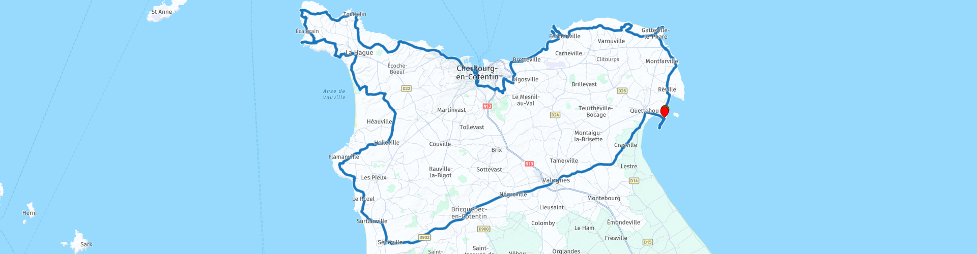
Roundtrip from Saint Vaast la Hougue through the Cotentin de La Manche

This route was brought to you by:
RouteXpert Catherine De Groote RouteXpert
Last edit: 25-04-2021
 Route Summary
 The Cotentin peninsula in Normandy has a surprising variety of landscapes, each with its own atmosphere. Famous are the large sandy beaches where the Americans and British landed in 1944, drive a few kilometers further and the coast has turned into high cliffs.
 Share this route


Animation

Verdict


Duration
8h 30m

Mode of travel
Car or motorcycle

Distance
211.52 km

Countries

 RouteXpert Review
 Barfleur is a small fishing village firmly anchored in the Cotentin. You will find one of the most picturesque harbors of La Manche.
In Gatteville we turn to the lighthouse. It is the second highest in France: 74.85 meters. When climbing the tower you should definitely count the stairs because there are as many as there are days in a year. And there are as many windows as there are weeks ...
The battery of Néville, code name Blankenese, is a monument of La Manche located in the delegated municipality of Néville-sur-Mer in Vicq-sur-Mer. It is part of the Atlantic Wall.
It was built on the tip of Néville in 1942 by the German navy (Kriegsmarine). It is equipped with 4 British Vickers anti-aircraft guns. The entire battery consists of about thirty bunkers along the beach, connected by galleries.
The Cap Lévi lighthouse is located in Fermanville, a charming village halfway between Gatteville-le-Phare and Cherbourg. Eighty-eight meters high, one hundred and thirteen steps, the Fermanvillais lighthouse draws attention with its geometric allure. Its shape is square and not cylindrical, unlike its Gattevillais neighbor. Founded in 1858, destroyed during the D-Day landings in 1944, the Cape Lévi lighthouse was rebuilt after the war.
Flanked by wild landscapes and a lush coastline with changing colors. You will pass the charming little port of Pignot and the fortress of Cap Lévi, not to be confused with the lighthouse of the same name. The last Napoleonic fortress in Cotentin, the fortress is a magical place where you can sleep in one of the guest rooms.
Built at the beginning of the 19th century, the fortress of Cap Lévi took part in the defense of Cherbourg harbor, which was converted into a second home by Charles Henry Dumas-Vence until 1939. The fort resumed service during the First and Second World Wars, where it was bombed during the last war.
Bought by Mr. Félix Amiot, owner of the CMN, who converted it into a prestigious residence for his distinguished guests. Located in the heart of the Val de Saire coastline, it is now a place of discovery and stay in a group lodge.
You keep following the coast where you have beautiful viewpoints over the coastline.
The Château de Ravalet is also known as the Château de Tourlaville. The castle of Ravalet, embellished with a beautifully landscaped park, stands on a large estate of almost twenty hectares. The gardens that can be visited have been labeled Remarkable Garden since the 2000s. The castle is still in the form of an enormous building with round corner turrets, with attic floors from the 19th century. Outside, visitors can admire the Porte des Quatre-Vents with its dormers and Corinthian pilasters, while the curious will have the chance to meditate in the blue room, that of Marguerite, who was beheaded on Place de Grève in Paris at the beginning of the 18th century because of incest.
The battery of Roule is part of the fortifications dug during the Second World War, in the heart of the mountain of Roule. At the time, these cannon-equipped tunnels were intended to protect the great artificial harbor of Cherbourg.
Equipped with a caving helmet with headlamp, there is a very special atmosphere and the visit is accompanied and commented on by a guide.
La Cité de la Mer is a unique tourist attraction in Normandy. You can board the Redoutable, the world's largest submarine. The standard audio tour is offered in Dutch, the family version is available in English and French. Relive the legend of the Titanic, boarding from its stop in Cherbourg and experience the 4 days at sea until the night of its demise. An interactive track 'Titanic, the return to Cherbourg' reveals the deck, the 1st, 2nd and 3rd class gangways, the message cabin… in a reconstructed setting of the mythical ship. Discover a fantastic and, above all, unique collection of submarines that will make you want to become an explorer.
From the car park you have a beautiful view of the harbor and the marina of Cherbourg.
The Abbaye du Voeu is a former abbey, founded in 1145, which became a barracks and then a hospital. The site presents many and interesting relics, including a refectory and a chapter house from the 13th century. The abbey house, which has been converted into an exhibition space, presents to visitors the beautiful tomb of the priest Guillaume from 1280.
Leave the hustle and bustle of Cherbourg and drive to the westernmost tip of the peninsula which is green, welcoming and prosperous. Here you will find chalk cliffs and capes interspersed with beaches of fine sand or pebbles and dunes.
The small fishing port in France has a lot of charm: Port Racine. Port Racine has built a special name in France: it is said to be the smallest port in the country! That is debatable: but the fact is that the harbor is tiny and very beautiful. Only boats with a maximum length of 5.50 m and a width of 2 m are allowed in the harbor. And the surrounding landscape is immediately reminiscent of the Irish coasts. It is therefore no coincidence that the Cotentin is also called Little Ireland.
A highlight is the Goury lighthouse and rescue post with a beautiful viewpoint, located 'at the end of the world' on Cap Hague. Here you can see the Raz Blanchard, one of the strongest ocean currents in the world. This is indicated by the Goury lighthouse or also called the Hague lighthouse, located 800 m from the Cap de la Hague. He greets the Gatteville lighthouse in the Val de Saire. Also discover the port of Goury, the semaphore and the typical stone walls of La Hague, overlooking the Anglo-Norman island of Alderney.
You try to drive as close to the coast as possible so that you can enjoy beautiful views.
High, rugged capes of rock where fierce waves crash against, especially crown the northwest. Nez de Jobourg and Nez de Voidries (the latter can only be reached on foot) are cliffs more than 100 meters high covered with heathland. The cliffs here are dizzyingly high. In the distance, the Channel Islands beckon. This wild landscape is breathtakingly beautiful, except… if you are afraid of heights. The chalk cliffs are no less than 128 meters high.
You have a very nice view at the Panorama des Treize Vents.
The granite protruding points are interrupted by sandy bays. Mass tourism has not yet penetrated the pleasant town of Vauville. It is located in a beautiful bay. A nature reserve with a lake of 20 hectares where birds feel at home also adorns the municipality. Only a row of dunes separates the sea from this freshwater lake.
The Mare de Vauville National Nature Reserve, which you will follow for 3 km, is a protected natural area of primary importance in the Manche department. It consists of a huge pool of fresh water, isolated from the sea by a narrow cordon of dunes, and is home to more than 2,300 species of birds, amphibians, dune plants and wetlands.
The castle of Flamanville dates mainly from the 17th century, but the existence of a large stately building is confirmed as far back as the 14th century. It is surrounded by a park of several hectares enriched with forests, ponds and a beautiful octagonal tower. The dahlia garden, which is open to the public all year round, contains 1,150 species.
In Baubigny you leave the coast for good and head through the interior to the end of the route.
Bricquebec Castle is located in the town of the same name. Tradition has it that the first castle was built on this site by a certain Anslech, of Scandinavian descent, who was related to the Duke of Normandy; William Long-Sword. The myth has it that in 1270 the Knights Templar, who already had numerous other possessions in the area, founded a commandery in the castle, based on the architectural layout of the castle. In 1857 the castle was visited by Queen Victoria of England and in 1957 by Field Marshal Montgoméry.
Via Vallognes you come back to Saint-Vaast-la-Houghe where you drive a short while to the Vauban fort. The fort is located on the broad spur of an elongated headland to the south of the city. It consists of three parts. First, the land front. This consists of two half bastions with in between the entrance gate with a large bridge over the canal. All the way on the other side, about 800m away, is the large, sea-facing artillery battery. This is the second part of the fort. The land front and the battery are connected by a boundary wall that encloses a large, elongated central area. There is a dike around the entire ring wall so that there is always water between the sea and the fort, regardless of the tide. In the middle area is a hill, this is the most famous part of the fort. The tower. The third part. The tower is made up of the joining of two towers, both tapered towards the top. The larger of the two contains the living and storage areas and has a large artillery platform for 6 guns on the roof. In the small tower is the spiral staircase that gives access to all floors and the artillery platform. Around the tower is a low wall with a small guardhouse. There are loopholes for muskets in the wall. The tower can be visited and is still in very good condition. The rest of the fort is off limits. The fort has since been declared a Unesco World Heritage Site.
The route is awarded 5 points. You enjoy an exceptionally beautiful landscape. You drive along beautiful chalk cliffs where you have beautiful views of the sea and the surrounding area. The small harbors, lighthouses, some castles and fortresses make the trip very varied. The roads wind their way up and down the coast and are of very good quality.


 Links
Links  Usage
Usage Want to download this route?
You can download the route for free without MyRoute-app account. To do so, open the route and click 'save as'. Want to edit this route?
No problem, start by opening the route. Follow the tutorial and create your personal MyRoute-app account. After registration, your trial starts automatically.  Disclaimer
Use of this GPS route is at your own expense and risk. The route has been carefully composed and checked by a MyRoute-app accredited RouteXpert for use on TomTom, Garmin and MyRoute-app Navigation.
Changes may nevertheless have occurred due to changed circumstances, road diversions or seasonal closures. We therefore recommend checking each route before use.
Preferably use the route track in your navigation system. More information about the use of MyRoute-app can be found on the website under 'Community' or 'Academy'.

Normandy
About this region
Normandy (/ˈnɔːrməndi/; French: Normandie [nɔʁmɑ̃di] (About this soundlisten); Norman: Normaundie; from Old French Normanz, plural of Normant, originally from the word for "northman" in several Scandinavian languages)[2] is a geographical and cultural region in Northwestern Europe, roughly coextensive with the historical Duchy of Normandy.
Normandy comprises mainland Normandy (a part of France) and the Channel Islands (mostly the British Crown Dependencies). It covers 30,627 square kilometres (11,825 sq mi).[3] Its population is 3,499,280. The inhabitants of Normandy are known as Normans,[1] and the region is the historic homeland of the Norman language. Large settlements include Rouen, Le Havre and Cherbourg.
The cultural region of Normandy is roughly similar to the historical Duchy of Normandy, which includes small areas now part of the departments of Mayenne and Sarthe. The Channel Islands (French: Îles Anglo-Normandes) are also historically part of Normandy; they cover 194 square kilometres (75 sq mi)[4] and comprise two bailiwicks: Guernsey and Jersey, which are British Crown Dependencies.
Normandy's name comes from the settlement of the territory by Vikings ("Northmen") starting in the 9th century, and confirmed by treaty in the 10th century between King Charles III of France and the Viking jarl Rollo. For four hundred years following the Norman conquest of England in 1066, Normandy and England were linked by having the same person reign as both Duke of Normandy and King of England.
Read more on Wikipedia
Normandy comprises mainland Normandy (a part of France) and the Channel Islands (mostly the British Crown Dependencies). It covers 30,627 square kilometres (11,825 sq mi).[3] Its population is 3,499,280. The inhabitants of Normandy are known as Normans,[1] and the region is the historic homeland of the Norman language. Large settlements include Rouen, Le Havre and Cherbourg.
The cultural region of Normandy is roughly similar to the historical Duchy of Normandy, which includes small areas now part of the departments of Mayenne and Sarthe. The Channel Islands (French: Îles Anglo-Normandes) are also historically part of Normandy; they cover 194 square kilometres (75 sq mi)[4] and comprise two bailiwicks: Guernsey and Jersey, which are British Crown Dependencies.
Normandy's name comes from the settlement of the territory by Vikings ("Northmen") starting in the 9th century, and confirmed by treaty in the 10th century between King Charles III of France and the Viking jarl Rollo. For four hundred years following the Norman conquest of England in 1066, Normandy and England were linked by having the same person reign as both Duke of Normandy and King of England.
View region
 Statistics
  15
15Amount of RX reviews (Normandy)
 18643
18643Amount of visitors (Normandy)
 1528
1528Amount of downloads (Normandy)
 Route Collections in this region
 3 day mini break through Brittany and Normandy
The overnight ferry crossing from Plymouth to Roscoff is a relaxing way to begin your 3 days of sightseeing in North West France. Touring the coasts and countryside of Brittany and Normandy, you'll discover beautiful sandy beaches, tiny fishing ports, bustling market towns and iconic and historical sites. Don't forget to sample Brittany's renowned seafood and delicious sweet and savoury pancakes, or Normandy cider and of course their 'hard to say no to' apple brandy, Calvados .
Day 1 takes you along the beautiful and rugged coast to Mont St Michel, a World Heritage site, visible for miles around. This is a wonderful place at any time of year, although be prepared for it to be very busy in summer. Your first hotel is just 30 minutes further along the coast at Hôtel Ibis Avranches Baie du Mont Saint-Michel. Other hotels are nearby and links for this hotel and your second night at Port en Bessin are in the individual route reviews.
Day 2 takes you first to Bayeux, world famous for its astonishing tapestry depicting the Norman Conquest of England in 1066, remarkable as a work of art and important as a source for 11th-century history. Bayeux also has a picturesque old quarter, WW2 museum and cathedral worth visiting (park motorcycles next to cathedral).
Then you can take in the sobering atmosphere at Pegasus Bridge, liberated by the British 6th Airborne Division glider unit, a full size replica of a Horsa glider shown in the picture above is on display, and the tale of the men it transported gives you a remarkable insight into the scale, ferocity and poignancy of Operation Overlord. Arromanches' Mulberry Harbour (Port Winston) and the gun emplacements dotted along the coast that you'll visit are reminders of the combats that took place here over 70 years ago. A great night is guaranteed at your second hotel in the fishing port of Port en Bessin where you can sample local cider (cidre) some of the freshest seafood available, fine wine, and finish off with some local calvados.
Day 3 tells the American story of D-Day with visits to Omaha and Utah beaches, various museums and the first town in France to be liberated during operation Overlord - Sainte-Mère-Eglise where an effigy of private John Steele dangles by his parachute from the church steeple.
Your return to the UK is via Cherbourg, to either Poole or Plymouth depending on the time of year, most sailings are around 17:00 hrs. Details from Brittany Ferries can be found in the link in the first review.
This is a great mini tour that'll give you a good glimpse of what this part of northern France has to offer and will leave you wanting to return.
View Route Collection
The 10 most downloaded routes in France from RouteXpert Catherine De Groote
Hello and welcome to this collection of the Top 10 MyRoute app downloaded routes in France.
A great new event will be announced soon, where all of these routes can be driven.
Download them all now and place them in a new "Top 10" folder so that you always have them at hand.
If you are going to drive one of these routes in the meantime, track them with the MRA Mobile App or with MRA Navigation. Take some photos (moments) along the way as they will come in handy.
Create a travelogue of your Top 10 driven routes and add the recorded track to it.
There will also be some great prizes on offer, so keep an eye on the MRA-RouteXperts page and your email.
View Route Collection