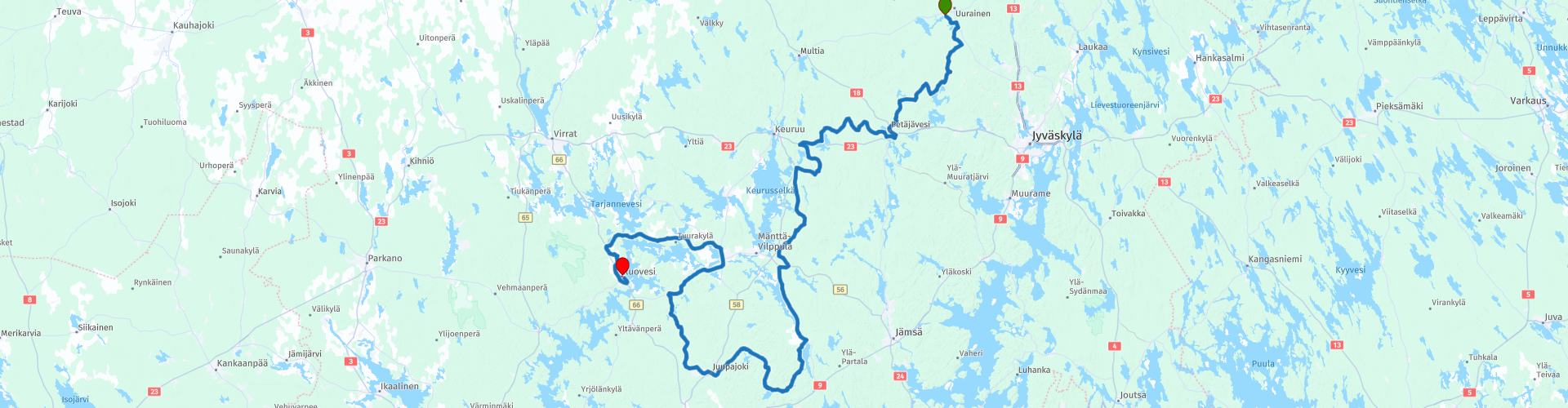
R08 Uurainen to Ruovesi

This route was brought to you by:
RouteXpert Hans van de Ven (Mr.MRA)
Last edit: 20-03-2021
 Route Summary
 Endless long days in the summer, so enjoy the midnight sun. During this tour you will discover the Finnish Lake District, the largest lake area in Europe! The blue lakes and green islands are interspersed with forests, hills, rivers and canals.
In any case, bring equipment to chase away the mosquitoes, because there are plenty of them, and what always remains are the moose that come out of the woods on the road, so watch out!
You will usually drive on good roads this trip, but keep in mind that it will often be gravel-covered roads. This 4-star rated route through Finland's unspoiled nature lets you enjoy every bend and countless lakes.
Hyvä matka!
Starting point: Uurainen, Marjoniementila Oy
End point: Ruovesi, Hotelli Liera & Hostelli Lieran Sellit
The route is equalized for Garmin, TomTom and MRA Navigation.
 Share this route


Animation

Verdict


Duration
9h 36m

Mode of travel
Car or motorcycle

Distance
270.47 km

Countries

 RouteXpert Review
 Stop for a photo or eat a sandwich on the way? No problem more than enough options where you can have a picnic or take an unforgettable photo.
General information:
Finland, officially the Republic of Finland, is a state in Northern Europe with a population of 5,571,665. Finland borders Russia to the east, Norway to the north and Sweden to the northwest. To the south it is separated from Estonia by the Gulf of Finland.
The capital is Helsinki, and the second largest city and metropolitan area is Tampere, which is about 180 kilometers north of Helsinki. Finland has been called 'the land of a thousand lakes'; in reality there are about 168,000 lakes. The largest lake is Lake Saimaa. In the southeast, the country is dotted with innumerable lakes and ponds.
Finland has a humid continental climate with short, warm summers and long, cold winters. Precipitation falls in the form of rain, hail and snow in all months of the year. In the south, the summers are warmer than can be expected at this high latitude. The temperature can reach more than 30 ° C. This is due to high-pressure areas that migrate from the Russian steppe to Scandinavia during the summer. In the rest of Finland, the summers are cool with long dry spells. This is mainly due to the proximity of the Atlantic Ocean with its warm Gulf Stream.
In the far north, summer lasts 73 days and the midnight sun can be seen. Lapland is covered with a thick layer of snow for a large part of the winter months. Much of Finland is covered with snow for more than half of the year. The amount of rainfall in the northern part of Lapland varies from less than 400 millimeters in the southwest to more than 600 millimeters in the southeast. In Lapland, 1 to 2 meters of snow can fall annually.
Because there is so little sunlight during the winter months, it cools down considerably. In the polar nights the temperature can drop to -35 ° C.


 Links
Links  Usage
Usage Want to download this route?
You can download the route for free without MyRoute-app account. To do so, open the route and click 'save as'. Want to edit this route?
No problem, start by opening the route. Follow the tutorial and create your personal MyRoute-app account. After registration, your trial starts automatically.  Disclaimer
Use of this GPS route is at your own expense and risk. The route has been carefully composed and checked by a MyRoute-app accredited RouteXpert for use on TomTom, Garmin and MyRoute-app Navigation.
Changes may nevertheless have occurred due to changed circumstances, road diversions or seasonal closures. We therefore recommend checking each route before use.
Preferably use the route track in your navigation system. More information about the use of MyRoute-app can be found on the website under 'Community' or 'Academy'.
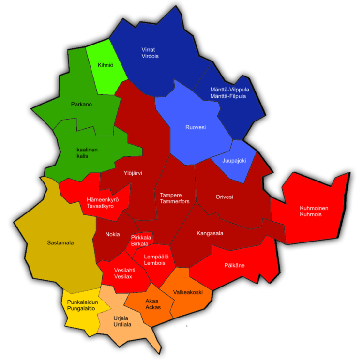
Pirkanmaa
About this region
Pirkanmaa (Finnish: [ˈpirkɑˌmːɑː]; Swedish: Birkaland; Latin: Birkaria), also known as Tampere Region in government documents, is a region of Finland. It borders the regions of Satakunta, South Ostrobothnia, Central Finland, Päijät-Häme, Kanta-Häme and Southwest Finland. Most of the water area in the Kokemäki River watershed is located in the Pirkanmaa region, although Lake Vanajavesi is partly in the Kanta-Häme region. The region got its name from Pirkkala, which in the Middle Ages comprised most of present-day Pirkanmaa. Tampere is the regional center and capital of Pirkanmaa, and at the same time the largest city in the region.
The total population of Pirkanmaa was 520,532 on 30 September 2020, which makes it the second largest among Finland's regions after Uusimaa. The population density is well over twice the Finnish average, and most of its population is largely concentrated in the Tampere sub-region.
Read more on Wikipedia
The total population of Pirkanmaa was 520,532 on 30 September 2020, which makes it the second largest among Finland's regions after Uusimaa. The population density is well over twice the Finnish average, and most of its population is largely concentrated in the Tampere sub-region.
View region
 Statistics
  4
4Amount of RX reviews (Pirkanmaa)
 5886
5886Amount of visitors (Pirkanmaa)
 293
293Amount of downloads (Pirkanmaa)
 Route Collections in this region
 Top car and motorcycle routes in southern Finland
Finland is the land of tranquility, of unspoilt nature, of a thousand lakes, of reindeer, of moose and of the northern lights. Steer along the thousand lakes like the famous rally drivers do in their rally cars.
Endless long days in the summer, so enjoy the midnight sun. During this tour you will discover the Finnish Lake District, the largest lake district in Europe! The blue lakes and green islands are interspersed with forests, hills, rivers and canals.
In any case, take things with you to repel the mosquitoes, because there are plenty of them, and what will always remain are the moose that just walk up the road from the woods, so pay attention!
You will mostly drive this trip on good roads, but keep in mind that it will often be gravel-covered roads. The routes in this collection through the untouched nature of Finland, let you enjoy every bend and countless lakes.
The Finnish road network was developed relatively late. Until the 1960s, many through-valatite were still unpaved or a gravel road. In 1938 the Finnish road network was numbered for the first time. Since many roads were still gravel roads for a long time, the main roads have often been built over a new route, so that Finnish main roads often have a more optimal alignment compared to other European countries, where they follow historical routes. In 1952 the Olympic Games were held in Helsinki. At that time, the country had almost no through asphalt roads. In 1962, Finland's first highway, the Valatie 1 between Helsinki and Espoo, opened. In the 1960s, only a few short highway routes were built around the major cities. It was not until the 1990s that longer stretches of motorway between the Finnish cities were completed.
Finland has a limited network of highways, called moottoritite, with 4 longer radial highways from Helsinki to Turku, Tampere, Heinola and towards the Russian border. In addition, there are a number of shorter highways around the largest cities, such as Oulu, Vaasa, Imatra and Kuopio. Finland also has the northernmost highway in the world, the Valatie 29 between Kemi and Tornio. The motorway network is being expanded on a limited scale, mainly because the traffic volumes are low. Roads from 15,000 vehicles are often widened to a motorway every 24 hours. The priority is the construction of the Valtation 7 to the border with Russia. There are 3 ring roads around Helsinki, the Kehä I to III, although Kehä II is barely a ring. These have not (yet) been classified as motorcycles.
A Moottoritie (plural: Moottoritiet) is the term for a motorway in Finland. The country has a relatively small network, connecting most major cities in the south. The Moottoritie is a status, Moottoritiet often runs on the main roads, called Valtation. European roads can also be part of this. The Finnish highway network is 995 kilometers long.
Best travel period
The best time to visit Finland is in the months of June, July, August and September. In these months the chance of precipitation is lowest and the chance of good weather is greatest.
Blow off steam in one of the many Finnish saunas
Finland is really a sauna country. Every Finnish family has at least one sauna on average. For the Finns it is the way to relax, and it is very different than in the Netherlands.
What to do? First you have to take a short, cold shower after which you are only allowed to enter the sauna after having dried up. You also get a bunch of branches, also called a Vihta, with which you can hit your skin (ouch!) to increase blood circulation. After this, you dive into a cold water bath to cool off. (The real diehards also rub themselves with snow!) Afterwards you can enter the sauna again.
It takes some getting used to, but once you've done this a few times and feel the difference between hot and cold, you'll feel completely relaxed.
Hyva matka!
View Route Collection
6500 kilometers through Scandinavia with the highlights of the Lofoten and the North Cape
The Arctic Challenge Tour, on which this 26-part tour is partly based, is not a speed race. It's a tour. It comes down to agility, good navigation and anticipation. The participants are obliged to adhere to the speed limit of the country concerned. The participants must find the ideal route with the shortest possible distance by complying 100% with the locally applicable traffic rules. Of course, also take maximum speeds into account. The organization checks for violations of the speed limit. In case of gross or repeated exceeding of the maximum speed, disqualification for the relevant stage and for the final classification will follow. Control of the route and speeds is done by means of a track and trace system. This equipment is installed in every vehicle. You can then follow each team accurately in the Back Office. Those staying at home, interested parties and participants can also see the performances of the teams, because you can be followed live via the Internet. The Back Office takes action when a team gets into trouble. (source: website The Arctic Challenge)
That's quite a luxury, having a back office behind you that keeps an eye on you. Most of us will not have that and are on our own or the fellow traveler(s). The only agreement you have with the participants is that you also have to abide by the rules. Fortunately, you don't have to complete this tour in 9 days, like the participants, but you can take it a little longer.
The highlight of the Arctic Challenge in 2020 was the Lofoten, an island group northwest of Norway. The Lofoten archipelago is located in the middle of the wild Norwegian Sea, well above the Arctic Circle. This special region offers a beautiful landscape with imposing mountains, deep fjords and long, wild sandy beaches where the sound of the seabird colonies can always be heard.
The archipelago is best known for its rich fishing tradition. The Lofoten makes a prosperous impression despite their isolated location. The entire economy revolves above all around fishing. The image of the Lofoten is mainly dominated by wooden racks with cod, which hangs to dry. Lofoten fishing has been a household name for centuries. In the middle of winter, the ships set out to catch the fish in just a few months. The rich fishing grounds are due to the North Atlantic Warm Gulf Stream around the islands, in which the fish have their spawning grounds. Oil drilling is not permitted around Lofoten and the cod spawning grounds there.
The next destination for the participants was Sirkka, also known as Levi, a winter sports resort in Finnish Lapland. They stayed there for a few days to go ice-karting and to enjoy the snow by going on a snowmobile or skiing trip. This tour also takes you to Sirkka, but instead of staying there for a few days, you have the option to continue to the North Cape, the second highlight of this trip.
Imagine a place in the far north, where the Atlantic Ocean meets the icy waters of the Arctic Ocean. This place is the North Cape in Western Finnmark in Northern Norway. From here, only the archipelago of Spitsbergen lies between you and the North Pole and the sun shines for 2.5 months at a time; from mid-May to the end of July. Many visitors admire the midnight sun or the sunset over the Barents Sea from the North Cape plateau.
With each route you will find a review with a description of the route, where you pass and what to see along the way. It is also briefly described how the participants in the Arctic Challenge in 2020 had to drive it anyway, from which point to which point. Along the way, markings (route points) have been included that indicate the end points of the stages that the participants had to complete. As mentioned, they covered the distance in 9 days, stages of more than 1000 kilometers were no exception.
Each route ends at a hotel. It is of course not an obligation to use these hotels, you can always find another place to stay in the area, that decision is up to you. My experience, however, is that they are all simple but good hotels for a very reasonable price. They are known and can be booked at booking.com.
The routes of these collections:
R01 - Puttgarden to Angelholm, 280km
R02 - Angelholm to Alingsas, 281km
R03 - Alingsas to Mysen, 261km
R04 - Mysen to Rena, 312km
R05 - Rena to Orkanger, 306km
R06 - Orkanger to Grong, 292km
R07 - Grong to Mo i Rana, 290km
R08 - Mo i Rana to Bodo, 231km
R09 - Roundtour Bodo to Lofoten part 1, 314km
R10 - Roundtour Bodo to Lofoten part 2, 250km
R11 - Roundtour Bodo to Lofoten part 3, 291km
R12 - Bodo to Arjeplog, 295km
R13 - Arjeplog to Jokkmokk, 244km
R14 - Jokkmokk to Pajala, 239km
R15 - Roundtour Sirkka to North Cape part 1, 257km
R16 - Roundtour Sirkka to North Cape part 2, 300km
R17 - Roundtour Sirkka to North Cape part 3, 244km
R18 - Roundtour Sirkka to North Cape part 4, 275km
R19 - Roundtour Sirkka to North Cape part 5, 332km
R20 - Sirkka to Kemi, 299km
R21 - Kemi to Ylivieska, 251km
R22 - Ylivieska to Jalasjarvi, 236km
R23 - Jalasjarvi to Turku, 279km
R24 - Stockholm to Askersund, 271km
R25 - Askersund to Varnamo, 224
R26 - Varnamo to Trelleborg, 259km
Have fun driving these routes!
View Route Collection