R18 Roundtour Sirkka to North Cape part 4

This route was brought to you by:
RouteXpert Arno van Lochem - Senior RX
Last edit: 24-04-2021
 Route Summary
 You can also see this eighteenth part as part 4 of a 5-part tour from Sirkka to the North Cape.
The routes are easy for everyone to drive and are on well-paved roads. It may be necessary to take a single hairpin bend, but these are perfectly doable.
If there is a piece of gravel in the route, a warning will be given and, if possible, a detour will be indicated.
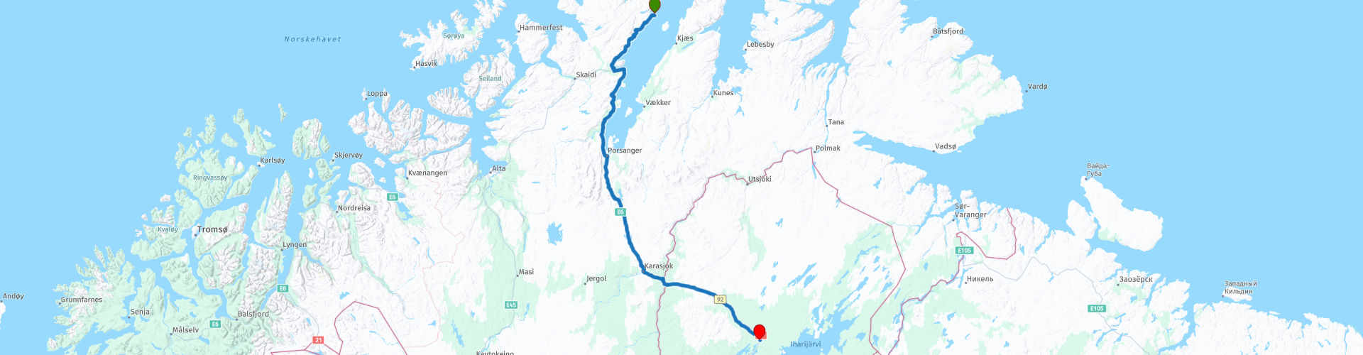
The route starts in Repvåg, just south of the North Cape. Along the way a lot, a lot of water, beautiful views of fantastic landscapes, making the road great. A pleasure to drive. After every turn a different fantastic view. Beautiful and interesting sights include a local silversmith, the Sámisk museum and Kevo Strict Nature Reserve.
There are not too many catering establishments, which is why it is better to ensure that you have something to eat and drink with you for the road.
Beautiful rugged landscape, beautiful scenic views, tight roads and beautiful sights, hence the 4-star rating.
 Share this route


Animation

Verdict


Duration
7h 40m

Mode of travel
Car or motorcycle

Distance
275.77 km

Countries


 RouteXpert Review
 Of all western European countries, the Scandinavian countries probably have the most more or less untouched nature. In addition, they are countries that are easily accessible from the Netherlands. Norway is characterized by, among other things, the fjords and the Trollstigen known to many motorcyclists. And where Sweden is known as wide and peaceful, everyone knows Finland as the land of 1000 lakes. All in all, legitimate reasons to traverse this beautiful nature in the north of Europe by means of a number of routes.
The route starts at the hotel in Repvåg, a small fishing village located on the western shore of the Porsangerfjorden. The village has about 15 inhabitants, but historically it was one of the most important port and trading places in the province of Finnmark, especially during the Pomor trade with Russia.
The water of the Porsangerfjorden largely determines your view of the first 110 kilometers of the route. This fjord, with a length of 123 kilometers, is Norway's fourth longest fjord.
Only a short while ago you will come to the Karvbergtunnel, a tunnel of 2,920 meters long. The current Skarvberg Tunnel is a single-tube tunnel along the Porsangerfjord and runs through a 300-meter-high ridge, about 18 kilometers north of the junction between the E6 and E69. The tunnel is part of the E69 to / from the North Cape and is now toll-free.
The Skarvberg Tunnel opened to traffic in 1970 and enabled the first fixed connection to the north of the peninsula. The road took on more significance from 1999 when the Nordkapptunnel opened and traffic no longer needed a ferry service to reach the North Cape.
If you drive out of the Skarvbergtunnels you will pass a silversmith, who has a summer shop along the E69, next to his silversmith in the nearby town of Tana.
What we call 'Sami silver' today is a modern expression for silver jewelry that was first produced at Juhl's Silver Workshop in Katokeino in the mid-1960s.
In the beginning, this jewelry consisted only of rings, molds (pilgrim marks), silver balls and other accessories for the national Sami dress, called 'kofte' in Norwegian. Later, new models were added, based on excavations of old bronze and silver jewelery from the Middle Ages.
In addition to Sami silver, jewelery with motifs of old Sami shaman drums, rock paintings and copies of museum collections is produced here.
Nice to pay a visit here and see if there is something nice for you.
A little further south you will pass Sjøsamisk Tun in Smørfjord, a small village on the west side of the Porsangerfjord. The approximately 100 inhabitants largely belong to the Sami people on the coast. Smørfjord has been a Sami settlement for centuries, and you can find cultural remains dating back to the Stone Age.
Built by local enthusiasts, Sjøsamisk Tun was officially opened in 2004. It is a reconstruction of a traditional Sami coastal settlement as seen around 1900. On the site you can see buildings made of peat and also a boathouse with traditional boats etc. In the kiosk they have local products and some souvenirs and refreshments. In connection with Sjøsamisk Tun you can also follow a well-marked path that leads through the village and the surrounding countryside, giving you a good impression of the Arctic nature.
In addition to welcoming tourists as visitors, Sjøsamisk Tun is also a meeting place for locals and anyone who wants to learn more about the local history, customs and traditions.
In Olderfjord you have the option to refuel if necessary. In the shop of this gas station you can also buy some snacks for on the road, it is always wise to have something to eat and drink with you in the area you drive through if a catering establishment is unexpectedly closed.
Ten kilometers further you will pass the Kistrand Kirke. This church is a tall church from 1856 and has 194 seats. It was inaugurated in 1856 and underwent a first restoration in 1928. In the period 2002 to 2006, a further restoration was carried out. The architect of the church was Christian Heinrich Grosch.
The current church replaced the old church on the site that was built in 1719. According to data, it should consist of a veranda and a nave, as well as a choir or sacristy. Two side wings were added in 1763 at the suggestion of Johan Ernst Gunnerus, who was Bishop of Nidaros. A further upgrade was made in 1803 due to the fact that Porsanger became the main parish. Nice to stop and take a look at this church.
You will pass the exit to Trollholmsund, a landmark consisting of an area consisting of dolomite (limestone) that was created about 700 million years ago. The rock formation in Trollholmsund is linked to an ancient Sami legend. Legend has it that a walking troll came across the plateau. Some trolls apparently came north from Lakselv. They had a chest of gold and silver with them. They came to the sea and could not go any further. It was just before dawn and they were looking for holes big enough to hide. They failed and turned to stone when the sun rose.
Here we find, among other things, lap rose (Rhododendron Lapponicum), which must have lime, unlike other rhododendrons that want acidic soil.
It's a short distance from the route, about 3 miles drive and a mile or two walk, but well worth checking out.
After driving almost 100 kilometers you will find the Stabbursnes Nature House and Museum. This is a nature and culture information center in Finnmark and a visitor center for Stabbursdalen National Park. The center offers, among other things, a permanent exhibition of the nature and culture in Finnmark.
It is also possible to take a walk, which starts at the parking lot, through the beautiful nature of the park. The trail partly follows the Stabbursnes nature reserve. It is approximately 2.8 km one way and upon return you will return to the starting place. It takes approximately 45 minutes each way. The path is well marked and easy to follow. you walk through forests, along the river and on top of the Stabbursnes plateau there is a beautiful view of the inner Porsangerfjord. You can buy a small booklet describing nature at the Nature House.
After the coffee break and just before the refueling stop, drive along the exit to the Sámisk museum, which was founded in 1972 as Sámi's first cultural institution in Norway. The museum has more than 5,000 objects in its collections. This is the largest museum collection representing the cultural history of Sámi in Norway. The museum consists of a main building with exhibitions and magazines and an open-air museum.
The unique collection includes objects representing the household, livelihoods, traditional Sámi clothing, religion, duodji (arts and crafts) and art from all over the Sámi area across national borders.
Hardly in Finland do you immediately turn off for the lunch break at Kalastajan Majatalo. After this lunch you are barely in the saddle before the first Finnish attraction comes into view. It concerns Kevo Strict Nature Reserve. Here you can experience the landscape of Lapland in its most wonderful way. There are two marked hiking trails where hikers can explore the area. Both routes are quite demanding.
The 40 km long and in some places almost 80 meters deep canyon-like valley of the Kevojoki River forms the core of the area. The rest of the nature reserve is upland crisscrossed by gentle slopes of ravines. There are also large tundra-like open swamps.
The purpose of the creation of the nature reserve was to protect the Kevo Gorge and the delicate fall landscape that surrounds it. The Kevo area is scientifically valuable. The University of Turku subarctic research station is conducting varied research in Kevo. Within the strict nature reserve, visitors are only allowed to move on marked trails.
The walk might be a bit too much, but it is certainly worth it to walk to the viewpoint, a walk of 350 meters up and back. That's easy to do and well worth it.
The route ends at a fairly remote location called Kaamasen Kievari, an apart hotel with good reviews. Equipped with all conveniences such as a bar and a restaurant, so that the route can be evaluated again while enjoying a beer. There is also a sauna, but a small fee is charged for this.
Two campsites are indicated for campers in the vicinity of the end point: Neljän Tuulen Tupa and Jokitörmä.
Have fun driving this route!


 Links
Links  Usage
Usage Want to download this route?
You can download the route for free without MyRoute-app account. To do so, open the route and click 'save as'. Want to edit this route?
No problem, start by opening the route. Follow the tutorial and create your personal MyRoute-app account. After registration, your trial starts automatically.  Disclaimer
Use of this GPS route is at your own expense and risk. The route has been carefully composed and checked by a MyRoute-app accredited RouteXpert for use on TomTom, Garmin and MyRoute-app Navigation.
Changes may nevertheless have occurred due to changed circumstances, road diversions or seasonal closures. We therefore recommend checking each route before use.
Preferably use the route track in your navigation system. More information about the use of MyRoute-app can be found on the website under 'Community' or 'Academy'.
Lapland
About this region
Lapland may refer to:
Read more on Wikipedia
View region
 Statistics
  6
6Amount of RX reviews (Lapland)
 8000
8000Amount of visitors (Lapland)
 299
299Amount of downloads (Lapland)
 Route Collections in this region
 6500 kilometers through Scandinavia with the highlights of the Lofoten and the North Cape
The Arctic Challenge Tour, on which this 26-part tour is partly based, is not a speed race. It's a tour. It comes down to agility, good navigation and anticipation. The participants are obliged to adhere to the speed limit of the country concerned. The participants must find the ideal route with the shortest possible distance by complying 100% with the locally applicable traffic rules. Of course, also take maximum speeds into account. The organization checks for violations of the speed limit. In case of gross or repeated exceeding of the maximum speed, disqualification for the relevant stage and for the final classification will follow. Control of the route and speeds is done by means of a track and trace system. This equipment is installed in every vehicle. You can then follow each team accurately in the Back Office. Those staying at home, interested parties and participants can also see the performances of the teams, because you can be followed live via the Internet. The Back Office takes action when a team gets into trouble. (source: website The Arctic Challenge)
That's quite a luxury, having a back office behind you that keeps an eye on you. Most of us will not have that and are on our own or the fellow traveler(s). The only agreement you have with the participants is that you also have to abide by the rules. Fortunately, you don't have to complete this tour in 9 days, like the participants, but you can take it a little longer.
The highlight of the Arctic Challenge in 2020 was the Lofoten, an island group northwest of Norway. The Lofoten archipelago is located in the middle of the wild Norwegian Sea, well above the Arctic Circle. This special region offers a beautiful landscape with imposing mountains, deep fjords and long, wild sandy beaches where the sound of the seabird colonies can always be heard.
The archipelago is best known for its rich fishing tradition. The Lofoten makes a prosperous impression despite their isolated location. The entire economy revolves above all around fishing. The image of the Lofoten is mainly dominated by wooden racks with cod, which hangs to dry. Lofoten fishing has been a household name for centuries. In the middle of winter, the ships set out to catch the fish in just a few months. The rich fishing grounds are due to the North Atlantic Warm Gulf Stream around the islands, in which the fish have their spawning grounds. Oil drilling is not permitted around Lofoten and the cod spawning grounds there.
The next destination for the participants was Sirkka, also known as Levi, a winter sports resort in Finnish Lapland. They stayed there for a few days to go ice-karting and to enjoy the snow by going on a snowmobile or skiing trip. This tour also takes you to Sirkka, but instead of staying there for a few days, you have the option to continue to the North Cape, the second highlight of this trip.
Imagine a place in the far north, where the Atlantic Ocean meets the icy waters of the Arctic Ocean. This place is the North Cape in Western Finnmark in Northern Norway. From here, only the archipelago of Spitsbergen lies between you and the North Pole and the sun shines for 2.5 months at a time; from mid-May to the end of July. Many visitors admire the midnight sun or the sunset over the Barents Sea from the North Cape plateau.
With each route you will find a review with a description of the route, where you pass and what to see along the way. It is also briefly described how the participants in the Arctic Challenge in 2020 had to drive it anyway, from which point to which point. Along the way, markings (route points) have been included that indicate the end points of the stages that the participants had to complete. As mentioned, they covered the distance in 9 days, stages of more than 1000 kilometers were no exception.
Each route ends at a hotel. It is of course not an obligation to use these hotels, you can always find another place to stay in the area, that decision is up to you. My experience, however, is that they are all simple but good hotels for a very reasonable price. They are known and can be booked at booking.com.
The routes of these collections:
R01 - Puttgarden to Angelholm, 280km
R02 - Angelholm to Alingsas, 281km
R03 - Alingsas to Mysen, 261km
R04 - Mysen to Rena, 312km
R05 - Rena to Orkanger, 306km
R06 - Orkanger to Grong, 292km
R07 - Grong to Mo i Rana, 290km
R08 - Mo i Rana to Bodo, 231km
R09 - Roundtour Bodo to Lofoten part 1, 314km
R10 - Roundtour Bodo to Lofoten part 2, 250km
R11 - Roundtour Bodo to Lofoten part 3, 291km
R12 - Bodo to Arjeplog, 295km
R13 - Arjeplog to Jokkmokk, 244km
R14 - Jokkmokk to Pajala, 239km
R15 - Roundtour Sirkka to North Cape part 1, 257km
R16 - Roundtour Sirkka to North Cape part 2, 300km
R17 - Roundtour Sirkka to North Cape part 3, 244km
R18 - Roundtour Sirkka to North Cape part 4, 275km
R19 - Roundtour Sirkka to North Cape part 5, 332km
R20 - Sirkka to Kemi, 299km
R21 - Kemi to Ylivieska, 251km
R22 - Ylivieska to Jalasjarvi, 236km
R23 - Jalasjarvi to Turku, 279km
R24 - Stockholm to Askersund, 271km
R25 - Askersund to Varnamo, 224
R26 - Varnamo to Trelleborg, 259km
Have fun driving these routes!
View Route Collection