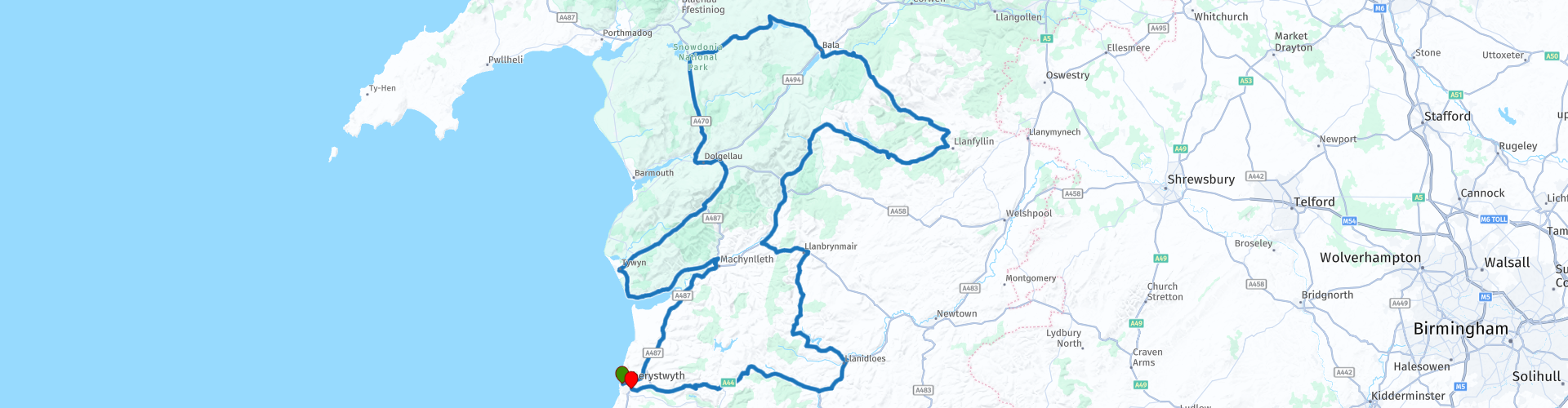
Snowdonia National Park South round trip from Aberystwyth

This route was brought to you by:
RouteXpert Will Brooks
Last edit: 07-09-2021
 Route Summary
  Share this route


Animation

Verdict


Duration
7h 35m

Mode of travel
Car or motorcycle

Distance
300.83 km

Countries

 RouteXpert Review
 Before turning onto the A493, you cross over the Grade2* listed Dyfi Bridge (Pont ar Dyfi) which is described as "one of the finest bridges in Montgomeryshire" by the Gwynedd Archaeological Trust. Initially a timber bridge, built in 1533, it was rebuilt in stone in 1681 and rebuilt again in 1805. The A493 is another good riding road and starts off narrower and tighter than previously, before opening up again giving you views of the beautiful Welsh countryside before once again changing character and turning into a glorious costal road as it hugs the coastline along to Aberdyfi and up to Tywyn for a suggested coffee stop.
There are a few choices for a break in Tywyn. I have stopped at Dolly's Cafe before which was friendly and did a decent coffee. Parking on the High Street is free for 45 mins. On a nice day it’s worth riding down to the beach for the views over Cardigan Bay.
Leaving Tywyn the route now heads inland further into Snowdonia National Park. Eventually hitting the B4405, a road that winds itself through valleys with vast hills either side, this is where you get your first realisation of the scale of the terrain. Further along the B4405 you will hit the beautiful Tal-y-llyn Lake (also known as Llyn Mwyngil). It is a 220 acre glacial ribbon lake situated at the foot of Cadair Idris in Southern Snowdonia. It was formed by a post-glacial landslip damming up the lake within the glaciated valley. The River Dysynni flows from the lake through the village of Abergynolwyn to the sea, north of Tywyn on the coast near Tonfanau. The road hugs the entire eastern side of the lake and the view is incredible.
Once past the lake you turn left onto the A487, another wide open A road and head into part of the Mach Loop before stopping at the Cad West Mach Loop viewing stop. The Mach Loop is a set of valleys, situated between Dolgellau in the north, and Machynlleth in the south (and from which the Mach Loop gets its name), which are regularly used for low level military flight training. Aircraft can fly as low as 250ft at over 450 knots but in certain areas can go as low as 100ft. With British and other countries military jets using this area it’s not uncommon to see Typhoons, Hawks, F15s, as well as larger Hercules and Airbus A400M. Actually seeing any low flying is, however, pot luck. There are no exact published timetables and flying only takes place through the loop from Mondays to Fridays (usually between 12.00 and 14.00), never on Bank Holidays and only when visibility is fairly good or better – hence the summer months tend to be the busiest times for plane enthusiasts to gather and it can get rather crowded. Park in the designated lay-by. If flying is taking place and you want a great view, where you’ll either be level with or above(!) the jets, head to the POI viewpoint. It is about a 15 min walk and climb from the lay-by. It is private land, which local farmers allow viewing, so please respect the land and keep litter with you. I’ve been lucky once and it was spectacular.
Now you have, a few twists and turns aside, a mostly straight 10 miles section of wide-open A road up to Trawsfynydd where you can take in the scenery. At Trawsfynydd turn right onto the A4212 which is a twisty and undulating road as the route starts to climb to higher altitude. You eventually arrive at Llyn Celyn reservoir where the road skirts round the west side before running along the north side. Here there is a photo opportunity stop in one of the lay-bys next to the reservoir. You get beautiful open views of the whole reservoir and across it for the peaks of Mynydd Nodol and Moel Y Garth. It was constructed between 1960 and 1965 in the valley of the River Tryweryn. It measures roughly 2.5 miles long by 1 mile wide and has a maximum depth of 140ft. It has the capacity to hold 71.2m cubic metres of water. It courted huge controversy at the time for the flooding of the village of Capel Celyn for its construction. A village that was seen as a stronghold of Welsh culture and the Welsh language, whilst the reservoir was being built to supply Liverpool and parts of the Wirral peninsula with water, rather than Wales.
After this stop continue on the A4212 through to the town of Bala. If you’re riding a bike with a small fuel range I’ve highlighted a fuel station in this town that you can visit off route should you need it, otherwise go through Bala and join the B4391.
Before joining the B4391 you’ll cross a bridge over Bala Lake (Llyn Tegid). It is over four miles long and a mile wide at its widest point, making it the largest natural lake in Wales. It is an important home for the rare 'gwyniad' fish - a species that became trapped in the lake at the end of the last Ice age some 10,000 years ago. It is a member of the whitefish family and is only found in Llyn Tegid. The lake takes its name from Tegid Foel, a character in the Mabinogi, the collection of early native Welsh tales, in which he is the husband of Ceridwen the enchantress.
For pure riding thrills, this next part is my favourite of the route. The next 20 miles of the B4391 can only be summed up as - breathtaking! This is one of the great roads to ride and it has everything from narrow tree covered stretches to wide open panoramic views of Snowdonia. There are hairpin turns and flowing bends all the while changing elevation as you wind through the valleys and peaks from 550ft up to 1600ft and back to 420ft before going up to over 1000ft again.
Just before Llanfyllin you turn right onto the B4396. This is another lovely stretch of road with plenty of elevation changes, although more classic, hedge lined, British B road all the way through to Lake Vyrnwy.
At Lake Vyrnwy and its Dam there is a stop for lunch. After crossing the dam turn left and park in one of the highlighted places. Light snacks and drinks are available at both Artisans and the Old Barn Café. Great pictures can be taken from both the marked Dam Viewing Point of the lake and surrounding scenery and from the Sculpture Gardens of the Dam itself. More formal dining can be found at the nearby Lake Vyrnwy Hotel where pre-booking is advised. Lake Vyrnwy reservoir and Dam were created and built in the 1880s to provide water to the City of Liverpool and also provided electricity to the village of Llanwwddyn up until 1960. The dam tower is often compared to a castle on the Rhine and is a well known feature of the Vyrnwy scene. The lake covers an area of 1,121 acres (the equivalent of around 600 football pitches) with a perimeter of 12 miles. When full it holds over 59 gigalitres of water and on a clear day can be seen from space!
After the stop continue following the road around the lake for what seems like an eternity (it’s 4.5 miles) and turn left off the main road onto an unclassified, single track road that starts your journey up to the highest point of the route and meanders through the peaks of the southern part of Snowdonia National Park. This is a time to simply pootle along taking in the incredible landscape and unlimited view. Outside of peak times you can go without seeing another vehicle or person and escape in your own solitude. You can also stop for a photo at any place you chose as it is so remote, but do keep an eye out for wandering wildlife, particularly sheep, that regularly roam onto the road. After coming down from the peak it’s back to the familiar windy road through the valleys passing through LLanymawddwy, Abercywarch and Dinas Mawddwy before picking up the A470 and following this through until LLanbrynmair.
Here you turn onto the B4518, another great narrow, twisty road down to Staylittle where you turn off onto an unclassified road, single track in most places, with superb open views before reaching Llyn Clywedog Reservoir. At the Clywedog Dam and Reservoir and Bryntail Lead Mine stop, turn left off the road following the sign to Bryntail Lead Mine and head down to the bottom to park. From here you can walk through the path to get to the Mine buildings and a view of the Dam. There is also another good viewpoint about 600yds back up the road you came.
Bryntail Lead Mine was once the hub of the busiest lead ore mining area in the world, when the Llanidloes area was a thriving lead smelting region. The site originally opened in 1708 and operated until mining stopped in 1788 but the mine workings continued to be used for almost a century after ore was discovered at nearby Y Fan. The discovery led to a boom in mining activity in the late 1800s. Between 1870 and 1880 the lead ore extracted was more than the rest of the world put together. The boom did not last, and by 1884 Bryntail closed down. The mine buildings quickly fell into decay. There are crushing houses, ore bins, water tanks, roasting ovens, and a barytes mill on the site, as well as administrative buildings such as the mine manager's office, storage buildings, and a smithy.
The Clywedog Reservoir was completed in 1967 primarily to regulate the flow in the River Severn to mitigate flooding and provide support for drinking water abstractions for the West Midlands. It also regulates the flow of water in the River Severn by releasing water into the river channel during low flow periods and re-filling during the wetter winter months. This enables major water abstractions to be made from the River Severn to supply the West Midlands with 50 million litres of drinking water. The reservoir was formed by damming both the Afon Clywedog and a much smaller embankment dam located at Bwlch-y-gle to prevent overflow into the next valley. The Clywedog Dam is a concrete buttress dam and the tallest concrete dam in the UK, (Height 236ft, Length 750ft). When at capacity the reservoir contains approximately 50 gigalitres of water.
After visiting the Reservoir and Mine you join back onto the B4518 further down for the short ride into Llanidloes. Here I’ve included a fuel stop at a Texaco station as it’s now nearly 160 miles into the route. If you also fancy a coffee stop I’ve highlighted the Great Oak café in the town centre which I’ve visited before. Otherwise, continue onto the A470 and then A44 for the final stretch back to Aberystwyth. This last leg finishes much like the route started with fast open and flowing A roads.


 Links
Links  Usage
Usage Want to download this route?
You can download the route for free without MyRoute-app account. To do so, open the route and click 'save as'. Want to edit this route?
No problem, start by opening the route. Follow the tutorial and create your personal MyRoute-app account. After registration, your trial starts automatically.  Disclaimer
Use of this GPS route is at your own expense and risk. The route has been carefully composed and checked by a MyRoute-app accredited RouteXpert for use on TomTom, Garmin and MyRoute-app Navigation.
Changes may nevertheless have occurred due to changed circumstances, road diversions or seasonal closures. We therefore recommend checking each route before use.
Preferably use the route track in your navigation system. More information about the use of MyRoute-app can be found on the website under 'Community' or 'Academy'.

Wales
About this region
Wales (Welsh: Cymru [ˈkəm.rɨ] (listen)) is a country that is part of the United Kingdom. It is bordered by England to the east, the Irish Sea to the north and west, and the Bristol Channel to the south. It had a population in 2011 of 3,063,456 and has a total area of 20,779 km2 (8,023 sq mi). Wales has over 1,680 miles (2,700 km) of coastline and is largely mountainous with its higher peaks in the north and central areas, including Snowdon (Yr Wyddfa), its highest summit. The country lies within the north temperate zone and has a changeable, maritime climate.
Welsh national identity emerged among the Britons after the Roman withdrawal from Britain in the 5th century, and Wales is regarded as one of the modern Celtic nations. Llywelyn ap Gruffudd's death in 1282 marked the completion of Edward I of England's conquest of Wales, though Owain Glyndŵr briefly restored independence to Wales in the early 15th century. The whole of Wales was annexed by England and incorporated within the English legal system under the Laws in Wales Acts 1535 and 1542. Distinctive Welsh politics developed in the 19th century. Welsh Liberalism, exemplified in the early 20th century by David Lloyd George, was displaced by the growth of socialism and the Labour Party. Welsh national feeling grew over the century; a nationalist party, Plaid Cymru was formed in 1925 and the Welsh Language Society in 1962. Established under the Government of Wales Act 1998, the Senedd (the Welsh Parliament, formerly known as the National Assembly for Wales) is responsible for a range of devolved policy matters.
At the dawn of the Industrial Revolution, development of the mining and metallurgical industries transformed the country from an agricultural society into an industrial nation; the South Wales Coalfield's exploitation caused a rapid expansion of Wales' population. Two-thirds of the population live in South Wales, including Cardiff, Swansea, Newport and the nearby valleys. Now that the country's traditional extractive and heavy industries have gone or are in decline, the economy is based on the public sector, light and service industries, and tourism. In livestock farming, including dairy farming, Wales is a net exporter, contributing towards national agricultural self-sufficiency.
Wales closely shares its political and social history with the rest of Great Britain, and a majority of the population in most areas speaks English as a first language, but the country has retained a distinct cultural identity. Both Welsh and English are official languages; over 560,000 Welsh-speakers live in Wales, and the language is spoken by a majority of the population in parts of the north and west. From the late 19th century onwards, Wales acquired its popular image as the "land of song", in part due to the eisteddfod tradition. At many international sporting events, such as the FIFA World Cup, Rugby World Cup and the Commonwealth Games, Wales has its own national team. At the Olympic Games, Welsh athletes compete for the UK as part of a Great Britain team. Rugby union is seen as a symbol of Welsh identity and an expression of national consciousness.
Read more on Wikipedia
Welsh national identity emerged among the Britons after the Roman withdrawal from Britain in the 5th century, and Wales is regarded as one of the modern Celtic nations. Llywelyn ap Gruffudd's death in 1282 marked the completion of Edward I of England's conquest of Wales, though Owain Glyndŵr briefly restored independence to Wales in the early 15th century. The whole of Wales was annexed by England and incorporated within the English legal system under the Laws in Wales Acts 1535 and 1542. Distinctive Welsh politics developed in the 19th century. Welsh Liberalism, exemplified in the early 20th century by David Lloyd George, was displaced by the growth of socialism and the Labour Party. Welsh national feeling grew over the century; a nationalist party, Plaid Cymru was formed in 1925 and the Welsh Language Society in 1962. Established under the Government of Wales Act 1998, the Senedd (the Welsh Parliament, formerly known as the National Assembly for Wales) is responsible for a range of devolved policy matters.
At the dawn of the Industrial Revolution, development of the mining and metallurgical industries transformed the country from an agricultural society into an industrial nation; the South Wales Coalfield's exploitation caused a rapid expansion of Wales' population. Two-thirds of the population live in South Wales, including Cardiff, Swansea, Newport and the nearby valleys. Now that the country's traditional extractive and heavy industries have gone or are in decline, the economy is based on the public sector, light and service industries, and tourism. In livestock farming, including dairy farming, Wales is a net exporter, contributing towards national agricultural self-sufficiency.
Wales closely shares its political and social history with the rest of Great Britain, and a majority of the population in most areas speaks English as a first language, but the country has retained a distinct cultural identity. Both Welsh and English are official languages; over 560,000 Welsh-speakers live in Wales, and the language is spoken by a majority of the population in parts of the north and west. From the late 19th century onwards, Wales acquired its popular image as the "land of song", in part due to the eisteddfod tradition. At many international sporting events, such as the FIFA World Cup, Rugby World Cup and the Commonwealth Games, Wales has its own national team. At the Olympic Games, Welsh athletes compete for the UK as part of a Great Britain team. Rugby union is seen as a symbol of Welsh identity and an expression of national consciousness.
View region
 Statistics
  22
22Amount of RX reviews (Wales)
 22176
22176Amount of visitors (Wales)
 2834
2834Amount of downloads (Wales)
 Route Collections in this region
 5 days through Wales on roads less travelled
As the title suggests, this is a 5 day tour through Wales on 'roads less travelled'. Each daily route has spectacular scenery through sometimes, dramatic landscapes. The tour visits some of Wales' well known sights and some not so well known. It travels across open moorland, deep valleys, the mountains of Snowdonia National Park and the beautiful countryside and coast. You will travel over historic bridges and see historic buildings and sights. This truly is an adventurous tour that I am certain you will enjoy.
View Route Collection
Top 10 Downloaded UK routes by RouteXpert Nick Carthew
Hello and welcome to this collection of the Top 10 MyRoute app downloaded routes in the UK.
There will be a great new event to be announced soon, where all these routes can be ridden.
Download them all now and place them in a new "Top 10" folder, so that you always have them at hand.
If you are going to drive one of these routes in the meantime, track them with the MRA Mobile App or with MRA Navigation. Take some photos (moments) along the way as these will come in handy.
Create a travelstory of your Top 10 driven routes and add the recorded track to it.
There will also be some great prizes on offer, so keep an eye on the MRA-RouteXperts page and your email.
View Route Collection