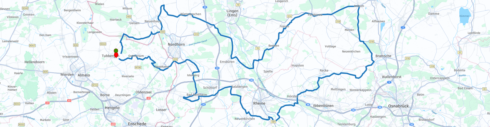
Rondrit Tubbergen Ankum Tubbergen

This route was brought to you by:
RouteXpert Marcel Scherpenkate
Last edit: 04-09-2021
 Route Summary
 I have equalized the route for TomTom, Garmin and MyRoute-app Navigation users.
I rate this route with 4 stars, I drove this route myself, a route to take a whole day for a nice motorbike and to visit a number of sights along the way.
 Share this route


Animation

Verdict


Duration
9h 22m

Mode of travel
Car or motorcycle

Distance
282.42 km

Countries


 RouteXpert Review
 These circles are also called Circles by Jannink or Beha van Jannink, together they form the largest landscape art project in the Netherlands. The artwork consists of two circular areas. The circular fields were laid out in the 1930s on the heathland of the former Marke (a medieval collective of larger farmers who jointly manage and use their communal land) in Mander on behalf of Gerhard Jannink, textile manufacturer and large landowner from Enschede. He had seen in North America that round fields had advantages over rectangular ones. The fields could be worked from the center in a spiral corridor so that the machines did not have to turn. Rye, oats and potatoes were grown alternately. After 1975 maize became the most important crop. When that no longer paid off, the land of Jannink was sold in 1991 to Landschap Overijssel. The circles have a diameter of 378 and 343 meters respectively. The area is accessed by a two-kilometer-long hiking trail around and over the circles. They serve as a beacon for pilots, they are probably the inventors of the nickname Beha by Jannink. In the late 1990s, artist Paul de Kort redesigned the area. The source of inspiration were prehistoric landscape tracks. A circle was dug in a ditch with a spiral labyrinth in the center which symbolizes a plow furrow. The other was provided with a rampart with an elevation in the middle of the round moorland, like a burial mound with fifty juniper bushes on top.
You continue your route and cross the Dutch-German border to turn right in Getelo towards Halle, a beautiful sloping road with a number of hills on both sides. The 89 meter high Poascheberg on the left side of the road is the highest point. On the nearby 87-meter-high Lönsberg, there is a 35-meter-high metal lookout tower which is accessible free of charge. With good visibility you can even see Nordhorn and Lingen, as well as the castle in Bad Bentheim. There is also a restaurant at the watchtower.
You continue on the Hesingerstrasse and arrive in the town of Lage, here you can visit the watermill of Lage.
The water mill of Lage dates from the 17th century. Characteristic are the two water wheels, from which a grain and oil mill track are driven. In the early years of the 20th century, electricity was also generated to power the village. The oil mill was closed after the First World War. The grain mill was in operation until 1957, although from 1931 it was no longer powered by water power, but by a diesel engine. After the death of the last miller, the mill was empty. When the building threatened to collapse, the most necessary security work began in 1962.10 years later, the County of Bentheim finally ordered an extensive external restoration of the mill. The mill is now in use for a few days a year. After the restoration, a tea room was set up in the former miller's apartment.
You continue the route for a short distance through the Graftschaft Bentheim and then drive into the lower Emsland. This part of the route is characterized by the many rivers and canals. You will pass ao: De Dinkel; The Vecht, the Süd-Nord Canal, and the Ems. Shortly after passing the Ems you arrive at the Venhaus lock, which is a lock complex on the Dortmund-Ems Canal. The Venhaus lock is part of the so-called Rheine lock staircase. On this approximately 29-kilometer-long stretch of canal between the Bevergern lock and the Gleesens lock, a height difference of almost 29 meters is bridged. The average fall height is 3.5 meters.
After about 1 hour of steering you arrive in Ankum, where you can stretch your legs at Het See und Sporthotel and possibly consume something. When you leave the parking lot, turn right onto the L70. You are now driving through a more wooded area via Uefeln in the direction of Bramsche, you avoid this large town by taking the first right at the roundabout to the K165. This road will bring you to the Mittelland canal.
At 325.7 kilometers, this canal is the longest artificial watercourse in Germany. The canal starts as a branch of the Dortmund-Ems Canal at Hörstel and then takes you past Bramsche, Osnabrück, Hanover, Wolfsburg and Magdeburg to the Elbe. Several of these larger cities are connected to the Mittelland Canal via side arms that come to a dead end in a harbor basin.
Then you drive 20 kilometers along the canal. In the distance you can already see the former mining dump at Dickenberg. On top of this former mine dump you have a beautiful view on a clear day. Mining ended here in 1979.
The route continues south along Rheine, you will pass the location where the Mittelland canal changes into the Dortmund Ems canal, the canal in which the recently passed lock complex is also located. The Dortmund-Ems Canal is a 265 kilometer long canal between the port of Dortmund and Emden. This canal also connects the Ruhr area and the east of Germany via the Mittelland canal. The canal is located in the far west of Germany and runs almost entirely along the Dutch border. It consists of a northern and a southern part. Construction of the canal started in 1892. During the peak years, more than 4000 employees were active. On August 11, 1899, the Dortmund-Ems Canal was officially opened by Kaiser Wilhelm II.
You will now leave North Rhine-Westphalia and return to the state of Lower Saxony and drive under the A31 motorway to Bad Bentheim. Here, a visit of Bentheim Castle and its Castle Garden is very worthwhile.
Bentheim Castle is a medieval castle built from sandstone blocks. This sandstone bears the name of the place: Bentheim sandstone. The castle is still inhabited, but the fortifications and some historic reception rooms can be visited. The living area is inhabited by the noble family of Bentheim und Steinfurt.
When you enter the castle you pass two gates. The lower gate dates from the thirteenth century. The upper gate was designed in the seventeenth century by the Dutch master builder Philips Vingboons. The Kronenburg is a Gothic residential building, which was renovated according to historical example in the late nineteenth century. The Powder Tower with its medieval dungeon got its current shape around 1525. Several architectural styles can be found in the castle, the Romanesque, Gothic and Renaissance styles. From the 30 meter high medieval powder tower you have a beautiful view over Westphalia and Twente in good weather.
After a possible visit you drive via the B403 through the Bentheimer Wald to the Isterberg, where you have a beautiful view from the viewing platform at 80 meters towards the Dutch border. In the summer months, motorcyclists gather in the parking lot under the watchtower on Sundays from 10 a.m. to meet each other.
After the Isterberg you drive a bit through the floodplains of the Vecht to then cross the German-Dutch border. You will return to Dutch soil via a small country road. Then south of Denekamp, partly via the ring road, goes to Landgoed Singraven.
In addition to the manor, the estate also includes the water mill 1448 on the Dinkel, a coach house in 1868 and a number of lease farms. The House itself dates from 1415. The name Singraven means "large canal". Residents / owners of the first house included the Oldenzaalse Begijnen and the counts of Bentheim. The dilapidated house was demolished in 1651-1653 and replaced by a new house to which a stair tower was added in 1661. Through inheritance, the house came into the possession of, among others, the De Thouars family and through sale in 1829 to the Roessingh Udink family. Several generations of this family have refurbished and renovated the estate. In addition, the facade was extended 4 meters to the front, the building houses at the front were demolished to obtain an unobstructed view and in 1868 a large driveway from Ootmarsumsestraat to the house was constructed. The last private resident / owner, Willem Frederik Jan Laan 1891-1966, gave the estate to the Edwina van Heek Foundation in 1966, even after extensive renovations and restorations.
The Singraven water mill consists of three water wheels with several mills: an oil mill, a flour mill and the sawmill.
You continue the route over the Schiphorstdijk, first a few hundred meters of cobblestones and then asphalt again. A small road through the estate. At the end of the road in front of the water we turn right onto the Kampstieweg along the Almelo Nordhorn canal to finally arrive at the Kuiperberg.
The Kuiperberg is 71 meters high. The Kuiperberg is part of the lateral moraine that extends from Ootmarsum to Uelsen in Germany. Other hills of this lateral moraine are the Braamberg 76 meters and further north the Overijsselse Galgenberg 68 meters. The highest point is the Poascheberg 89 meters just across the border, which we already passed at the beginning of the route. On the Kuiperberg is the Jewish cemetery of Ootmarsum, which dates from approximately 1786. On top of the Kuiperberg is an orientation table of the ANWB. This is a reminder of the federal parties of the Royal Dutch Touring Association ANWB in Twente on 22 and 23 July 1922.
Via a petrol station on the Ootmarsumseweg we drive via the Reutemmerweg to the end point Recreation Park `n Kaps.


 Links
Links  Usage
Usage Want to download this route?
You can download the route for free without MyRoute-app account. To do so, open the route and click 'save as'. Want to edit this route?
No problem, start by opening the route. Follow the tutorial and create your personal MyRoute-app account. After registration, your trial starts automatically.  Disclaimer
Use of this GPS route is at your own expense and risk. The route has been carefully composed and checked by a MyRoute-app accredited RouteXpert for use on TomTom, Garmin and MyRoute-app Navigation.
Changes may nevertheless have occurred due to changed circumstances, road diversions or seasonal closures. We therefore recommend checking each route before use.
Preferably use the route track in your navigation system. More information about the use of MyRoute-app can be found on the website under 'Community' or 'Academy'.

North Rhine-Westphalia
About this region
North Rhine-Westphalia (German: Nordrhein-Westfalen, pronounced [ˌnɔʁtʁaɪn vɛstˈfaːlən] (listen); Low Franconian: Noordrien-Wesfale; Low German: Noordrhien-Westfalen; Colognian: Noodrhing-Wäßßfaale), commonly shortened to NRW (German: [ɛnʔɛʁˈveː] (listen)), is a German state (Land) in Western Germany. With more than 17.9 million inhabitants, it is the most populous state of Germany. Covering an area of 34,084 square kilometres (13,160 sq mi), it is the fourth-largest German state by size. Apart from the city-states, it is also the most densely populated state in Germany.
North Rhine-Westphalia features 30 of the 81 German municipalities with over 100,000 inhabitants, including Cologne (over 1 million), the state capital Düsseldorf, Dortmund and Essen (all about 600,000 inhabitants) and other cities predominantly located in the Rhine-Ruhr metropolitan area, the largest urban area in Germany and the third-largest on the European continent. The location of the Rhine-Ruhr at the heart of the European Blue Banana makes it well connected to other major European cities and metropolitan areas like the Randstad, the Flemish Diamond and the Frankfurt Rhine-Main Region.
North Rhine-Westphalia was established in 1946 after World War II from the Prussian provinces of Westphalia and the northern part of Rhine Province (North Rhine), and the Free State of Lippe by the British military administration in Allied-occupied Germany and became a state of the Federal Republic of Germany in 1949. The city of Bonn served as the federal capital until the reunification of Germany in 1990 and as the seat of government until 1999.
Culturally, North Rhine-Westphalia is not a uniform area; there are significant differences, especially in traditional customs, between the Rhineland region on the one hand and the regions of Westphalia and Lippe on the other. The state has always been Germany's powerhouse with the largest economy among the German states by GDP figures.
Read more on Wikipedia
North Rhine-Westphalia features 30 of the 81 German municipalities with over 100,000 inhabitants, including Cologne (over 1 million), the state capital Düsseldorf, Dortmund and Essen (all about 600,000 inhabitants) and other cities predominantly located in the Rhine-Ruhr metropolitan area, the largest urban area in Germany and the third-largest on the European continent. The location of the Rhine-Ruhr at the heart of the European Blue Banana makes it well connected to other major European cities and metropolitan areas like the Randstad, the Flemish Diamond and the Frankfurt Rhine-Main Region.
North Rhine-Westphalia was established in 1946 after World War II from the Prussian provinces of Westphalia and the northern part of Rhine Province (North Rhine), and the Free State of Lippe by the British military administration in Allied-occupied Germany and became a state of the Federal Republic of Germany in 1949. The city of Bonn served as the federal capital until the reunification of Germany in 1990 and as the seat of government until 1999.
Culturally, North Rhine-Westphalia is not a uniform area; there are significant differences, especially in traditional customs, between the Rhineland region on the one hand and the regions of Westphalia and Lippe on the other. The state has always been Germany's powerhouse with the largest economy among the German states by GDP figures.
View region
 Statistics
  136
136Amount of RX reviews (North Rhine-Westphalia)
 61670
61670Amount of visitors (North Rhine-Westphalia)
 27827
27827Amount of downloads (North Rhine-Westphalia)
 Route Collections in this region
 The 10 most beautiful car and motorcycle routes in Limburg
Limburg, who thinks of Limburg, thinks of flan, coal mines, marl and the hill country. The coal mines have been closed for almost 40 years, the last load of coal was brought up from the Oranje-Nassau coal mine in Heerlen on 31 December and, as they say, South Limburg was transformed from Black to Green and unfortunately there is still little left. view of this period.
But not only pie, marl and coal in Limburg, but also a very beautiful province to tour by car or motorcycle and enjoy all the beauty that the province of Limburg has to offer. For this, the MyRoute app RouteXpert has put together a Top 10 of Car and Motorcycle routes for you.
All routes in this collection have been checked and made equal for TomTom, Garmin and MyRoute-app Navigation by a MyRoute-app RouteXpert.
If you think, I have a very nice route that should certainly not be missing from this collection, send it to:
email: routeexpert@myrouteapp.com
Subject: New Route for the Top 10 collection Province of Limburg composed by Hans van de Ven.
The route will then be reviewed and then added to the Top 10.
To make the Top 10 also the Top 10, 1 route will have to disappear from the Top 10, you can indicate this when submitting the new route.
Have fun with this collection and while driving one of these routes. Enjoy all the beauty that the Netherlands and in particular the province of Limburg has to offer. Click on “View route” to read the review of the chosen route.
I would like to hear your findings about the route(s).
View Route Collection
Top 5 Car and Motorcycle Routes in the Eifel
The Eifel is the eastern part of the medium plateau Eifel-Ardennes. It is located north of the Moselle and west of the Rhine. The largest part is in Germany, a small part is in Belgium, in the East Cantons. The German part of Eifel is located in the federal states of North Rhine-Westphalia and Rhineland-Palatinate. The highest point is the Hohe Acht with 747 meters.
Several chains can be distinguished in the Eifel:
The northernmost part is called the Nordeifel, which in Belgium connects to the High Fens;
To the east of this is the Ahrgebirge, this part is located north of the Ahr in the Ahrweiler district;
South of the Ahr is the Hohe Eifel (or Hocheifel), of which the Hohe Acht (747 m) is the highest point, and also the highest point in the entire Eifel region;
To the west, near the Belgian border, the hills are known as Schneifel, part of the wider Snow Eifel area with peaks reaching up to 698 metres;
South and east of the Hohe Eifel is the Volcano-Eifel, a volcanic area with many crater lakes (Maare).
The southern part of the Eifel is less high. The area is bisected by streams and rivers running southwards. These streams flow into the Moselle. The largest of these rivers is the Kyll; the hills around this river are known as the Kyllwald;
In the south, the Eifel ends in the Voreifel.
In the north of the Eifel there are some large reservoirs. The largest of these is the reservoir in the Roer that was created by the construction of the Roerdal dam.
The Nürburgring is also located in the Eifel, a well-known car circuit for Formula 1 races, among other things. Since 2004, part of the north of the Eifel has become the Eifel National Park. This National Park falls entirely within the German-Belgian nature park High Fens-Eifel. Another part of the Eifel falls within the South Eifel Nature Park.
Well-known throughout the Netherlands and Belgium by car and motorcyclists, so reason enough for the MyRoute app RouteXpert to compile a Top 5 of Car and Motorbike routes for you.
All routes in this collection have been checked and made equal for TomTom, Garmin and MyRoute-app Navigation by a MyRoute-app RouteXpert.
If you think, I have a very nice route that should certainly not be missing from this collection, send it to:
email: routeexpert@myrouteapp.com
Subject: New Route for the Top 5 collection Eifel composed by Hans van de Ven.
The route will then be reviewed and then added to the Top 5. To make the Top 5 also the Top 5, 1 route will have to disappear from the Top 5, you can indicate this when submitting the new route.
Have fun with this collection and while driving one of these routes. Enjoy all the beauty that the Eifel has to offer. Click on “View route” to read the review of the chosen route.
I would like to hear your findings about the route(s).
View Route Collection