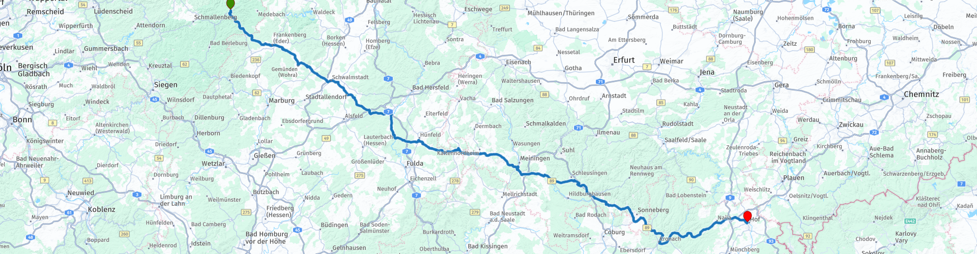
Day 02 Silk Road Winterberg Hof

This route was brought to you by:
RouteXpert René Plücken (MRA Master)
Last edit: 26-04-2022
 Route Summary
 This day we drive through beautiful mountainous areas in Germany such as Thuringia, Rhön and Sauerland.
We drive on provincial roads interspersed with beautiful winding country roads. The roads are asphalted and of very good quality.
The landscape is beautifully green and we pass beautiful German villages and towns with the typical craftsmen's houses, churches and castles, where a visit can be planned.
I rate this route with 4 stars because of the beautiful nature and beautiful roads through a rolling and sometimes mountainous landscape.
 Share this route


Animation

Verdict


Duration
8h 16m

Mode of travel
Car or motorcycle

Distance
346.66 km

Countries

 RouteXpert Review
 The first option is the Hallenberg Forest after approximately 10 kilometers of driving. This nature reserve extends over more than 2000 hectares with differences in height, green valleys and many small waterways. The area is located between the towns of Hallenberg and Winterberg. From the mountain peaks (between 680 and 815 meters), visitors can see far into the Rothaar Mountains.
Viewpoints such as the Ziegenhelleturm at 810 meters and the Heidekopfturm at 703.8 meters offer a beautiful 360 degree panoramic view of the area. Many hiking trails are in the area or go through, so well worth a visit.
Along the route we pass several fortresses, fortresses and castles that in some cases have been adapted to be used as a church, these are well worth a short stop.
Some examples of this are:
• The church fortress of Belrieth, this castle was built in the time of the Henzeberg. Rebuilt in the 12th century, the castle is said to have occupied the space of the present church courtyard. The conversion of the castle into a church fortress took place after the War of the Henneberg Succession in 1379. The fortified complex still has all 26 alleys with vaulted cellars from the 16th/17th century.
• The Vachdorf church fortress, one of the largest and best preserved of its kind. There is a moated castle with a double wall ring, a kennel, four corner towers with bastions in front, two entrance gates and a drawbridge over the moat. The castle complex and the church use probably developed in parallel. This sacred building is made of wood, clay and earthworks, as these were the main building materials in the 15th century.
• The Schaumburg ruins are located on a mountain and were once an imposing castle, today only isolated remains of the wall remain. Visit these ruins and take a trip back in time to the Middle Ages. The castle was probably built around 1150 by Hermann von Wohlsbach. After 1500 it was expanded into a modern fortress and survived many crises and wars in the period that followed. It was destroyed during the 30 Years War.
• Neuhaus Castle in the center of the village of the same name. The castle was built in the 13th century. During the 30 Years War it was used for military purposes. After the 30 Years War, it was used as a quarry and storage shed for the Amtshaus until the 19th century. Baron Hermann von Walther redesigned it in 1903 into a neo-Renaissance style castle. Until 1980 the historical museum of the municipality of Neuhaus-Schierschnitz was located there. Today it is owned by the DRK Regional Association of Thuringia.
Along the route we pass several rivers and beautiful (reservation) lakes, a lunch stop is planned at the reservoir "Bergsee Ratscher".
The Ratscherdam is a flood defense dam in Thuringia, which is also used for tourism and is therefore also called "Bergsee Ratscher". The 15 meter high dam is made of gravel and has an outer seal of asphalt concrete. At the reservoir is a bathing beach with a camping site and water sports facilities. There are a number of events every year, including a country and rock festival. There is a restaurant for lunch. In the lake is a small island which was made by the construction workers during the construction of the dam in the middle of the lake.
It is also possible to take a longer break or even spend the night here to enjoy the beautiful nature.
The end point of day 2 is in the town of Hof, in the center there are several hotels to spend the night, there are no campsites in the vicinity.


 Links
Links  Usage
Usage Want to download this route?
You can download the route for free without MyRoute-app account. To do so, open the route and click 'save as'. Want to edit this route?
No problem, start by opening the route. Follow the tutorial and create your personal MyRoute-app account. After registration, your trial starts automatically.  Disclaimer
Use of this GPS route is at your own expense and risk. The route has been carefully composed and checked by a MyRoute-app accredited RouteXpert for use on TomTom, Garmin and MyRoute-app Navigation.
Changes may nevertheless have occurred due to changed circumstances, road diversions or seasonal closures. We therefore recommend checking each route before use.
Preferably use the route track in your navigation system. More information about the use of MyRoute-app can be found on the website under 'Community' or 'Academy'.

North Rhine-Westphalia
About this region
North Rhine-Westphalia (German: Nordrhein-Westfalen, pronounced [ˌnɔʁtʁaɪn vɛstˈfaːlən] (listen); Low Franconian: Noordrien-Wesfale; Low German: Noordrhien-Westfalen; Colognian: Noodrhing-Wäßßfaale), commonly shortened to NRW (German: [ɛnʔɛʁˈveː] (listen)), is a German state (Land) in Western Germany. With more than 17.9 million inhabitants, it is the most populous state of Germany. Covering an area of 34,084 square kilometres (13,160 sq mi), it is the fourth-largest German state by size. Apart from the city-states, it is also the most densely populated state in Germany.
North Rhine-Westphalia features 30 of the 81 German municipalities with over 100,000 inhabitants, including Cologne (over 1 million), the state capital Düsseldorf, Dortmund and Essen (all about 600,000 inhabitants) and other cities predominantly located in the Rhine-Ruhr metropolitan area, the largest urban area in Germany and the third-largest on the European continent. The location of the Rhine-Ruhr at the heart of the European Blue Banana makes it well connected to other major European cities and metropolitan areas like the Randstad, the Flemish Diamond and the Frankfurt Rhine-Main Region.
North Rhine-Westphalia was established in 1946 after World War II from the Prussian provinces of Westphalia and the northern part of Rhine Province (North Rhine), and the Free State of Lippe by the British military administration in Allied-occupied Germany and became a state of the Federal Republic of Germany in 1949. The city of Bonn served as the federal capital until the reunification of Germany in 1990 and as the seat of government until 1999.
Culturally, North Rhine-Westphalia is not a uniform area; there are significant differences, especially in traditional customs, between the Rhineland region on the one hand and the regions of Westphalia and Lippe on the other. The state has always been Germany's powerhouse with the largest economy among the German states by GDP figures.
Read more on Wikipedia
North Rhine-Westphalia features 30 of the 81 German municipalities with over 100,000 inhabitants, including Cologne (over 1 million), the state capital Düsseldorf, Dortmund and Essen (all about 600,000 inhabitants) and other cities predominantly located in the Rhine-Ruhr metropolitan area, the largest urban area in Germany and the third-largest on the European continent. The location of the Rhine-Ruhr at the heart of the European Blue Banana makes it well connected to other major European cities and metropolitan areas like the Randstad, the Flemish Diamond and the Frankfurt Rhine-Main Region.
North Rhine-Westphalia was established in 1946 after World War II from the Prussian provinces of Westphalia and the northern part of Rhine Province (North Rhine), and the Free State of Lippe by the British military administration in Allied-occupied Germany and became a state of the Federal Republic of Germany in 1949. The city of Bonn served as the federal capital until the reunification of Germany in 1990 and as the seat of government until 1999.
Culturally, North Rhine-Westphalia is not a uniform area; there are significant differences, especially in traditional customs, between the Rhineland region on the one hand and the regions of Westphalia and Lippe on the other. The state has always been Germany's powerhouse with the largest economy among the German states by GDP figures.
View region
 Statistics
  136
136Amount of RX reviews (North Rhine-Westphalia)
 61336
61336Amount of visitors (North Rhine-Westphalia)
 27647
27647Amount of downloads (North Rhine-Westphalia)
 Route Collections in this region
 The 10 most beautiful car and motorcycle routes in Limburg
Limburg, who thinks of Limburg, thinks of flan, coal mines, marl and the hill country. The coal mines have been closed for almost 40 years, the last load of coal was brought up from the Oranje-Nassau coal mine in Heerlen on 31 December and, as they say, South Limburg was transformed from Black to Green and unfortunately there is still little left. view of this period.
But not only pie, marl and coal in Limburg, but also a very beautiful province to tour by car or motorcycle and enjoy all the beauty that the province of Limburg has to offer. For this, the MyRoute app RouteXpert has put together a Top 10 of Car and Motorcycle routes for you.
All routes in this collection have been checked and made equal for TomTom, Garmin and MyRoute-app Navigation by a MyRoute-app RouteXpert.
If you think, I have a very nice route that should certainly not be missing from this collection, send it to:
email: routeexpert@myrouteapp.com
Subject: New Route for the Top 10 collection Province of Limburg composed by Hans van de Ven.
The route will then be reviewed and then added to the Top 10.
To make the Top 10 also the Top 10, 1 route will have to disappear from the Top 10, you can indicate this when submitting the new route.
Have fun with this collection and while driving one of these routes. Enjoy all the beauty that the Netherlands and in particular the province of Limburg has to offer. Click on “View route” to read the review of the chosen route.
I would like to hear your findings about the route(s).
View Route Collection
Top 5 Car and Motorcycle Routes in the Eifel
The Eifel is the eastern part of the medium plateau Eifel-Ardennes. It is located north of the Moselle and west of the Rhine. The largest part is in Germany, a small part is in Belgium, in the East Cantons. The German part of Eifel is located in the federal states of North Rhine-Westphalia and Rhineland-Palatinate. The highest point is the Hohe Acht with 747 meters.
Several chains can be distinguished in the Eifel:
The northernmost part is called the Nordeifel, which in Belgium connects to the High Fens;
To the east of this is the Ahrgebirge, this part is located north of the Ahr in the Ahrweiler district;
South of the Ahr is the Hohe Eifel (or Hocheifel), of which the Hohe Acht (747 m) is the highest point, and also the highest point in the entire Eifel region;
To the west, near the Belgian border, the hills are known as Schneifel, part of the wider Snow Eifel area with peaks reaching up to 698 metres;
South and east of the Hohe Eifel is the Volcano-Eifel, a volcanic area with many crater lakes (Maare).
The southern part of the Eifel is less high. The area is bisected by streams and rivers running southwards. These streams flow into the Moselle. The largest of these rivers is the Kyll; the hills around this river are known as the Kyllwald;
In the south, the Eifel ends in the Voreifel.
In the north of the Eifel there are some large reservoirs. The largest of these is the reservoir in the Roer that was created by the construction of the Roerdal dam.
The Nürburgring is also located in the Eifel, a well-known car circuit for Formula 1 races, among other things. Since 2004, part of the north of the Eifel has become the Eifel National Park. This National Park falls entirely within the German-Belgian nature park High Fens-Eifel. Another part of the Eifel falls within the South Eifel Nature Park.
Well-known throughout the Netherlands and Belgium by car and motorcyclists, so reason enough for the MyRoute app RouteXpert to compile a Top 5 of Car and Motorbike routes for you.
All routes in this collection have been checked and made equal for TomTom, Garmin and MyRoute-app Navigation by a MyRoute-app RouteXpert.
If you think, I have a very nice route that should certainly not be missing from this collection, send it to:
email: routeexpert@myrouteapp.com
Subject: New Route for the Top 5 collection Eifel composed by Hans van de Ven.
The route will then be reviewed and then added to the Top 5. To make the Top 5 also the Top 5, 1 route will have to disappear from the Top 5, you can indicate this when submitting the new route.
Have fun with this collection and while driving one of these routes. Enjoy all the beauty that the Eifel has to offer. Click on “View route” to read the review of the chosen route.
I would like to hear your findings about the route(s).
View Route Collection