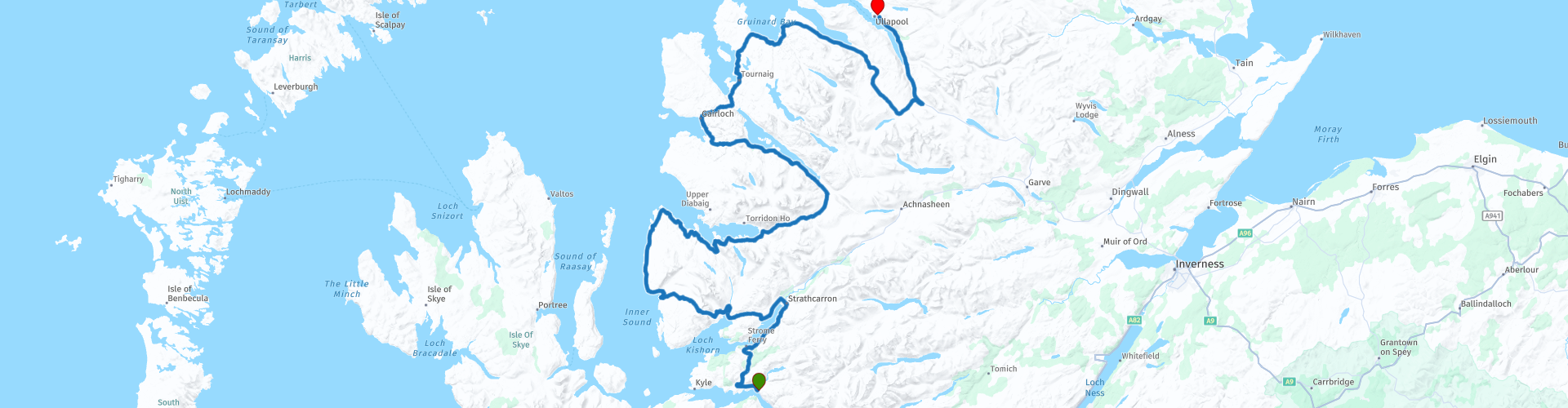
06 Dornie to Ullapool via Applecross

This route was brought to you by:
RouteXpert Nick Carthew - (MRA Master)
Last edit: 15-11-2021
 Route Summary
 From where you join the A890 at Strathcarron the remainder of this route and the final route (07) of the LeJog tour to John O'Groats will follow the route of the iconic NC500.
Some single track roads are used all in pretty good shape.
The Bealach na Bà can be closed in the colder months of the year (October - April) when snow and ice can occur. Check before leaving. I have included a link in the review for you to use for checking.
The breathtakingly beautiful and sometimes wild landscape earns this route 5***** stars.
 Share this route


Animation

Verdict


Duration
7h 37m

Mode of travel
Car or motorcycle

Distance
249.63 km

Countries

 RouteXpert Review
 The route follows the railway along the shore of Loch Carron to join the A890 at Strathcarron, from this point the route joins the iconic NC500 route all the way to Ullapool.
A warning sign before crossing over the River Kishorn indicates your arrival at the Applecross Peninsula. it might be the only road in the world that explicitly tells learner drivers to stay away!
This is the star of this route, the pass over the mountains of the Applecross Peninsula known as; Bealach na Bà, literally translating to ‘the pass of the cattle’, the road remains one of the most dangerous, steep and unforgettable to drive along, demanding complete concentration from those who dare to try it. But, as many who have conquered it would attest, the view from the top is worth the tension and is considered a holy grail for riders looking to give themselves a challenge.
Perhaps the closest thing to an Alpine pass in the UK, the road features very sharp hairpin turns, switching back and forth up the mountain, with gradients approaching 17%, the steepest ascent of any road in the UK. The road can be tricky because it is very narrow, with sharp bends and steep gradients. This twisting, single-track mountain road is one of the highest roads in the UK rising up to 626m (2,054ft). But the Bealach is an unforgettable ride up and along one of the most dramatic rivalling many a Swiss mountain pass and with terrific views across much of Wester Ross, the whole of Skye, and the Islands of Rum and the Outer Hebrides. You will NOT forget this drive as long as you live!
Having enjoyed the ride up, and assuming the weather is clear, there is a parking area on the left at the top with superb views. If that’s not enough, it is possible to walk a few hundred metres back from the parking area, and then left up a track that leads up to a transmitter station. The view gets better and better as you go…….
The road going down the other side is less steep but the views are equally as beautiful. The Applecross Inn makes a great place to stop for a coffee or bite to eat.
After your stop, you'll follow the shore of the Inner Sound and pass the British Underwater Test and Evaluation Centre (BUTEC). A group of white buildings on the water's edge designated in the 1970s as a range for testing torpedoes and other equipment such as SONAR. Then after reaching the northern tip of the peninsular the route follows Loch Torridon and Loch Shieldaig where you'll pass the much photographed Red Roof Cottage overlooking Loch Shieldaig that has arguably the best view in Scotland.
Shieldaig itself would be a finalist in any "most picturesque village in Scotland" competition. Its location is truly superb, on the edge of Loch Shieldaig. It was established in 1800 to attract families to take up fishing for a living & in the process, to help build up a stock of trained seamen who could be called upon by the Royal Navy during the Napoleonic wars. People were attracted to the village by the offer of grants from the Admiralty to support housing & boat-building, & Shieldaig flourished.
The route now heads inland for a short while to pass through Beinn Eighe National Nature Reserve. With a cluster of mountain peaks, ancient pinewoods, secretive crossbills and soaring golden eagles, it's no wonder that Beinn Eighe was chosen as Britain's first National Nature Reserve. From a distance, the pale scree slopes on the mountain-side look like barren fields of snow, but get up close and you'll be amazed by the diversity of wildlife that thrives on this reserve.
Loch Maree borders the National Nature Reserve to the north and is regarded as one of the most scenically attractive areas of Scotland. The loch itself is the largest in the north-west Highlands and lies in a glacial trough up to 110m deep. The area has attracted a clutch of conservation accolades which reflect the quality of its habitats, its scenic beauty and the rare plants and animals which are found here.
Rejoining the coast at Loch Gairloch, I have suggested a lunch stop here, great views while you eat your fish and chips and maybe you could visit the Gairloch Heritage Museum to learn about some local history. £5 for adults.
Loch Ewe is next and has an interesting history; during World War 2 it was a convoy collecting point for the Arctic convoys to Russia. Loch Ewe was protected by light and heavy anti aircraft guns. A boom net and mine defence system across the narrow mouth of this naturally deep harbour helped protect the vessels in Loch Ewe from German submarines.
The Arctic convoys that left from Loch Ewe provided vital supplies to Murmansk and Archangel in Russia. The last convoy sailed from Loch Ewe on the 30th December 1944. Altogether four hundred and eighty one merchant ships and over one hundred naval escort vessels left Loch Ewe for Russia in a total of nineteen convoys. For many hundreds of men who made the ultimate sacrifice, the cold grey water of the North Atlantic is their resting place. For these men the enfolding arms of Loch Ewe and the outer isles fading in the distance was the last sight of land they had, before the Russian convoys exacted their terrible price paid in human lives. This prompted Winston Churchill to declare the route “the worst journey in the world”. Nowadays Loch Ewe still has a naval presence, there is a NATO fuel station where naval vessels can refuel. The re-fuelling jetty can be seen from the road and a little further on is the Russian Arctic Convoy Museum where for a small fee of £5 you can read stories about the brave sailors who battled perilous Arctic waters, from the veterans themselves and their loved ones and see some artifacts too.
Another great place to stop at is Corrieshalloch Gorge, one of the most spectacular gorges of its type in Britain and provides striking evidence of how glacial meltwater can create deep gorges. This mile-long canyon, through which the River Droma rushes, takes its name from the Gaelic for ‘ugly hollow’. But that’s as far from the truth as can be.
You'll pass the main entrance for the gorge on your left with plenty of parking. The information board explains the routes available to you in order to view the gorge from the suspension bridge or viewing platform. The walk from here is about 45 minutes. Or, you can go past the gorge and stop at a parking layby on the other side. A small hop over the low barrier will lead you straight to the viewing platform.
A mile or so up the road is Loch Broom that will lead you to the end of this route at the picturesque fishing town and Hebrides ferry port of Ullapool. Being a ferry port, there is a great choice of accommodation to choose from.
Enjoy.


 Links
Links  Usage
Usage Want to download this route?
You can download the route for free without MyRoute-app account. To do so, open the route and click 'save as'. Want to edit this route?
No problem, start by opening the route. Follow the tutorial and create your personal MyRoute-app account. After registration, your trial starts automatically.  Disclaimer
Use of this GPS route is at your own expense and risk. The route has been carefully composed and checked by a MyRoute-app accredited RouteXpert for use on TomTom, Garmin and MyRoute-app Navigation.
Changes may nevertheless have occurred due to changed circumstances, road diversions or seasonal closures. We therefore recommend checking each route before use.
Preferably use the route track in your navigation system. More information about the use of MyRoute-app can be found on the website under 'Community' or 'Academy'.