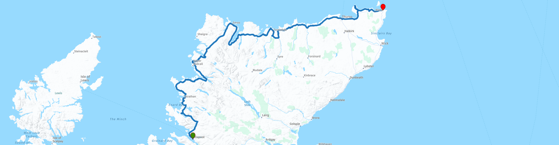
07 Ullapool to John O Groats

This route was brought to you by:
RouteXpert Nick Carthew - (MRA Master)
Last edit: 16-11-2021
 Route Summary
  Share this route


Animation

Verdict


Duration
8h 47m

Mode of travel
Car or motorcycle

Distance
311.89 km

Countries

 RouteXpert Review
 From Loch Lurgainn you have stunning views of Stac Pollaidh 612m, one of the most distinctive summits in Scotland, its steep pinnacled ridge is often likened to a porcupine.
The port of Lochinver is the largest settlement on the west coast of Scotland north of Ullapool. Lochinver’s harbour is the busiest of the 102 harbours and jetties in the Highland Council area. Here you are likely to see vessels from many parts of the world. Most are involved in some aspect of fishing, many landing catches at the large fish market. I have suggested a coffee stop here.
Suilven viewpoint. Suilven (731m) is probably the most recognisable mountain in Scotland due to its unique shape. Loved by tourists, photographers and hill walkers alike, and stunning from every angle. It’s not hard to see why Suilven is a true icon of Assynt and the Scottish Highlands.
Clachtoll Beach. With white sands and idyllic turquoise water, Clachtoll Beach is an unspoilt paradise in the Highlands. From the headlands at either end of the beach there are stunning mountain views for miles around. The beach has a free car park and there is a ranger’s hut where you can learn about the wildlife, geology and history of the beach.
Clashnessie Bay is a clean, quiet and beautiful beach. With a rocky inlet and a big sandy shore, the beach is a fabulous adventure for children and full of things to explore. A short walk upstream will take you to the Clashnessie Falls, a fifteen meter waterfall, dropping from the lochans above. Clashnessie Bay is famous for its ever changing weather and water colour, from tranquil turquoise to white foamy waves.
Drumbeg. A viewpoint with a car park has been constructed at the west end of village and from here you can take in the magnificent seascapes to the north. And from the rocky mound opposite the viewpoint, you can gain some of the best available views of the village, along the main street and taking in the peaks of Quinag to the east.
Kylesku Bridge. The bridge you see today was duly opened, in 1984, by HM Queen Elizabeth II. It must be one of the most beautiful examples of the bridge-builder's art anywhere in the world. It may only be 276m long, and may only cross a 130m width of water, but it is transformed into something very special by its wonderfully curved design, coupled with the stunning scenery of Sutherland.
Lunch and refuel at Durness.
Smoo Cave. The cave boasts one of the largest entrances to any sea cave in Britain at 50 ft high and is floodlit inside. It was formed by a burn that runs down into the rear chamber, as well as erosion caused by the sea. About a 10 minute walk from the car park.
Loch Eriboll. The 10-mile-long sea loch, close to Cape Wrath, was the only Scottish rendezvous point for U-boats, which had been the linchpins of Hitler’s plans to starve the UK of food, equipment and raw materials. Between May 10 and May 25, 1945, the loch became the scene of the biggest surrender of German submarines. 33 U-boat commanders gave up their vessels.
Ard Neakie. The lime kilns on Ard Neakie are a powerful reminder of a time when trade and travel were much more reliant on the waters. The lime kilns were once used for the production of lime, used in farming, which was loaded onto ships at the pier here and transported to be sold. There is a quarried area in the middle of the island just behind the kilns which is now flooded but is perfect for skimming stones nowadays.
The Kyle of Tongue (Kyle is a Scottish term for a strait of water). A bridge over this estuary was first suggested in the 1830's but the curved bridge and embankment structure you see today was not opened until 1971. Before the bridge was built there were two ways of getting across the water, a ferry or a 10 mile road trip around the Kyle.
Invernaver Bridge. The Bridge at Invernaver is an unusual construction, with the parapets actually being plated girders, which carry the load of the structure. It was opened by the Duke of Sutherland in the spring of 1881 at which time it was described as “picturesque”.
Dounreay Nuclear Power Station. Clearly visible from the road, currently being decommissioned and no longer producing power.
Thurso is mainland Scotland's most northerly town, the town's origins are revealed in its name, which comes from the Old Norse for Bull's River. The Vikings were well established here from as early as the 900s, using the river mouth as a port and a fishing base.
Dunnet Head. The most northerly geographical point on mainland Britain, Dunnet Head has stunning sea cliffs and coastal grassland. These are home to puffins, razorbills, guillemots and fulmars. Above the cliffs are some very diverse coastal heathland and grassland habitats with special plants such as spring squill, thrift and roseroot.
Castle Mey. The Castle of Mey was built by George, the 4th Earl of Caithness in 1573. Her Majesty Queen Elizabeth The Queen Mother bought Castle Mey in 1952. Despite its poor condition, Her Majesty purchased the castle that year and set about renovating and restoring both the castle and its gardens and parklands, which extended to about 30 acres.
John O'Groats. The end of this route and the Lands End to John O'Groats (LeJog) tour. While many see the village for its iconic ‘end of the road’ location, it’s part of an area rich in Scottish history and culture and deserving of a closer look, with a good choice of accommodation and a choice of local craft shops.
If you have travelled from Lands End, call into the Storehouse cafe to sign the End to Enders book. We were given a certificate and medal.
Enjoy.


 Links
Links  Usage
Usage Want to download this route?
You can download the route for free without MyRoute-app account. To do so, open the route and click 'save as'. Want to edit this route?
No problem, start by opening the route. Follow the tutorial and create your personal MyRoute-app account. After registration, your trial starts automatically.  Disclaimer
Use of this GPS route is at your own expense and risk. The route has been carefully composed and checked by a MyRoute-app accredited RouteXpert for use on TomTom, Garmin and MyRoute-app Navigation.
Changes may nevertheless have occurred due to changed circumstances, road diversions or seasonal closures. We therefore recommend checking each route before use.
Preferably use the route track in your navigation system. More information about the use of MyRoute-app can be found on the website under 'Community' or 'Academy'.