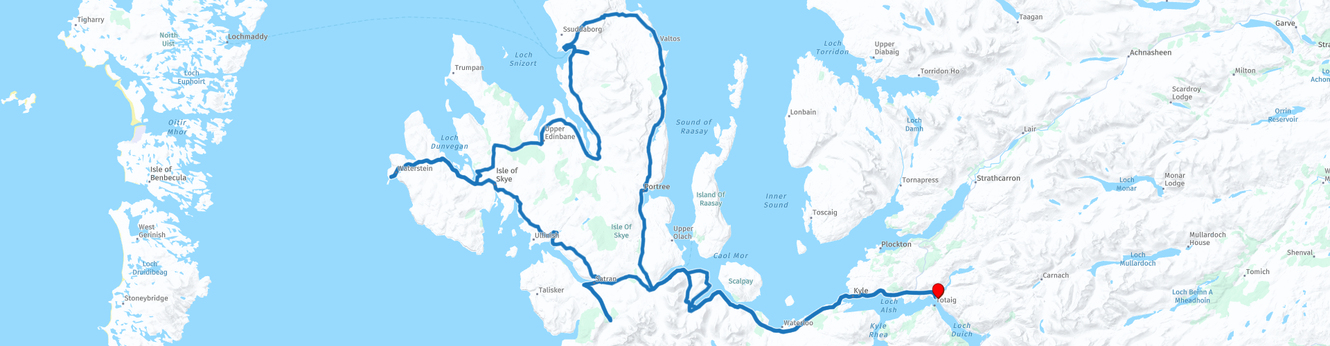
Isle of Skye roundtrip from Dornie

This route was brought to you by:
RouteXpert Nick Carthew - (MRA Master)
Last edit: 20-02-2024
 Route Summary
  Share this route


Animation

Verdict


Duration
11h 21m

Mode of travel
Car or motorcycle

Distance
307.93 km

Countries

 RouteXpert Review
 The Isle of Skye's main town, Portree, is a fantastic place to stop for a coffee. This bustling port revolves around its scenic harbour, complete with a picturesque row of rainbow houses. There is plenty of shopping on offer and plenty of restaurants from which to choose.
Leaving Portree, you'll soon see the Storr Lochs, these are made up of Loch Fada, with the larger Loch Leathan to the north. On the northern part of Loch Leathan, the dam for the Storr Lochs hydro-electric project was built creating the reservoir for the hydro electric project. Despite their industrial use, the lochs are beautiful to see.
Next comes The Bride's Veil Falls, a delightful waterfall next to the roadside that's easy to photograph.
One of Skye's most famous attractions is also very visible from the roadside; The Old Man of Storr. Numerous legends surround a group of majestic rocks known as The Storr. The Old Man of Storr is impossible to miss. This mysterious, and some would say haunted, marvel is a popular spot to take in stupendous views. While some believe The Old Man of Storr to be the thumb of a giant that once lived on Trotternish Ridge, others are content with a more scientific explanation: an ancient landslide created this spectacular wonder.
Lealt Falls is another great photo opportunity. Just a short walk from the parking area will take you to two viewing platforms with views of the Lealt Falls, the gorge and great views out to sea.
Kilt Rock and Mealt Falls is another of Skye's wonders of nature. The kilt-like pattern of sedimentary and igneous rocks led to this sea-cliff's unique name. Your first glimpse of this 90-meter wonder, located on the Trotternish Peninsula, will literally take your breath away. This dramatic cliff also boasts another of the top tourist attractions on the Isle of Skye, the Mealt Waterfall, a lavish cascade you will likely hear before you see. This impressive waterfall drops 51 meters into the Sound of Raasay, caressing the kilt-shaped basalt rock columns on its way down. If you listen closely, you can hear the whistle made by the falls as the water crashes down. Similar to a bagpipes' eerie tunes, this whistle becomes even more dramatic on a particularly windy day.
The Quiraing Pass will take you from east to west across the Trotternish Peninsula. Quiraing is a magnificent place steeped in both natural beauty and history. Formed by a series of substantial landslips, this area boasts abundant cliffs, rock pinnacles, and captivating plateaus. Small lakes dot the base of the craggy mountains, adding to the area's immense allure.
This region is in constant motion, which is why the nearby roads require constant repair. The most famous observation point is found at the top of the Quiraing Mountain Pass, where on a clear day, you can see to the seashore. Some say villagers hid their cattle in the Quiraing's hidden nooks and crannies in an effort to protect them from Vikings.
Lunch stop at Uig Harbour. Uig is one of three ports that form the 'Skye Triangle', providing “lifeline ferry services” to the communities of the Western Isles. Uig is also home to The Isle of Skye Brewing Company and the Uig Pottery, so grab some samples of their award winning ales and maybe a stoneware stein to drink from!
After lunch, a 5 minute ride will take you to Fairy Glen. While there's no proof this enchanted spot was created by fairies, a visit to Fairy Glen will have even the biggest cynic believing in magic. Fairy Glen is utterly divine and overtly enchanting. Grassy hills are ringed by paths worn down by the many sheep who call this ethereal land home. You'll find a ton of them wandering around the hilltops and hiding in the nooks and crannies spotted throughout the glen, bleating their welcome as you come near. One of the tallest hills in Fairy Glen maintains its basalt top, which looks like an ancient man-made tower. Fittingly, it has been named Castle Ewan.
The next stop involves a short detour of 200m along a dead end lane to see an ancient stone!
Clach Ard is a Pictish symbol stone and as such is a real rarity. To date, only 242 Pictish symbol stones have been found in Scotland. It has stood here since about 1880 when it was found being used as a door-jam during the demolition of a nearby cottage. The stone could be 1200 years old and is covered with Pictish symbols. Less is known about these symbols than is known about Egyptian hieroglyphics. This just adds another level of mystique to this magical isle.
The route now heads to the most westerly point on Skye, Neist Point, giving excellent views over Moonen Bay to Waterstein Head and out over the Minch to the Western Isles. The lighthouse at the far tip of Neist Point is one of the most famous lighthouses in Scotland. While the walk down to the lighthouse is an easy one, the concrete path does get quite steep at times. From the path you will see stunning views of the high cliffs and the lighthouse itself, at sunset the view is made even more spectacular making this a top destination for landscape photographers.
The route returns on the single track road from the lighthouse and heads south to stop at the ancient broch, Dun Beag.
Just a short walk from the parking is Dun Beag, an excellent example of a broch: a kind of Iron Age round stone tower only found in Scotland. It stands at the top of a rocky knoll commanding excellent views of the surrounding landscape. The broch would have been built around 2,000–2,500 years ago. It appears to have been occupied for a very long period as medieval and later coins were reportedly recovered from the site in the early 1900s.
The Black Cuillin mountain range becomes more prominent as you head further south with Sgùrr a' Ghreadaidh at 973m the highest summit on the northern half of the Black Cuillin ridge.
A magnificent slice of paradise is found at the foot of the Black Cuillin mountain range. Not easily spotted from the road, the spectacular Fairy Pools wow visitors who've made the easy 1.2km trek from the car park. While the looming mountain range entices travelers to turn their gazes upwards, the crystal-clear water of the intricate Fairy Pools is so captivating; you'll find it difficult to keep your eyes on anything else.
Located near the village of Glenbrittle, this incredible spot is so serene, you'll almost forget that you're sharing the view with many other travelers. If you're hoping for true solitude, visit early in the morning so you can have the place to yourself.
The crisp streams, deep emerald pools, and rushing waterfalls are a photographer's dream, while the sparkling water invites the bravest of travelers to jump into its icy embrace.
The final stop on Skye is at the Sligachan Hotel for a coffee. Here you'll also find Sligachan Old Bridge, the waters under the bridge are supposedly magical and offer you eternal beauty if you wash your face with them. This is another of the many architectural marvels engineered by Thomas Telford between 1810 & 1818.
After obtaining eternal beauty, the route takes you back over the Skye Bridge to Dornie.
Enjoy.


 Links
Links  Usage
Usage Want to download this route?
You can download the route for free without MyRoute-app account. To do so, open the route and click 'save as'. Want to edit this route?
No problem, start by opening the route. Follow the tutorial and create your personal MyRoute-app account. After registration, your trial starts automatically.  Disclaimer
Use of this GPS route is at your own expense and risk. The route has been carefully composed and checked by a MyRoute-app accredited RouteXpert for use on TomTom, Garmin and MyRoute-app Navigation.
Changes may nevertheless have occurred due to changed circumstances, road diversions or seasonal closures. We therefore recommend checking each route before use.
Preferably use the route track in your navigation system. More information about the use of MyRoute-app can be found on the website under 'Community' or 'Academy'.