Roundtour Gran Canaria day 3 South

This route was brought to you by:
RouteXpert Arno van Lochem - Senior RX
Last edit: 20-12-2021
 Route Summary
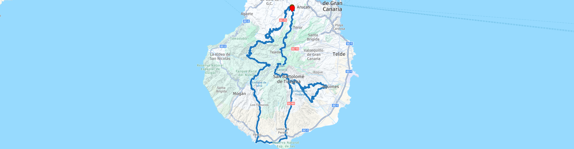
 The start of the route is in the small town of El Risco. The route is mainly about the smaller, beautiful roads, which are equipped with good asphalt. You really have to do your best to find a straight, it is all bends that you will encounter in the route. Assume that the straps will be fully used! After 245 kilometers you will return to El Risco.
After 150 kilometers it is possible to shorten the route by 50 kilometers, bringing the total length to 200 kilometers.
The route is for the more advanced motorcyclist. Be aware of tight hairpin bends!
Sights along the way include Balneario de Azuaje, Presa del Parralillo, Necrópolis de Arteara and a few spots with great views.
Because of the beautiful roads, the fantastic landscape and the nice sights, I rate this route with 5 stars.
 Share this route


Animation

Verdict


Duration
10h 33m

Mode of travel
Car or motorcycle

Distance
245.27 km

Countries

 RouteXpert Review
 Enjoy high quality roads, low traffic, spectacular views and endless curves. The landscape is so varied that you will never be bored. It is an absolute paradise for motorcyclists!
The route starts in El Risco and, like part 2, takes you north. After driving 5 kilometers you will pass Balneario de Azuaje, an abandoned spa town. There are few places in Gran Canaria that are really undiscovered, but Balneario de Azuaje is one of those places that you won't find in the travel guides. In fact, it's so hidden that many locals don't even know it! The 150-year-old Azuaje Spa makes the heart of every urban explorer beat faster. In short, do you love abandoned buildings, history and natural beauty? Then turn left, park your vehicle and get into the Urban Exploration!
Balneario de Azuaje or Spa Azuaje was once a prestigious spa town in a green barranco in the north of Gran Canaria. The spa was built about 150 years ago, in the year 1868. At that time, Balneario de Azuaje was a hotel with spa facilities and was popular with wealthy tourists and locals alike.
Once back on the road after this piece of Urban Exploration you will soon be driving on the GC-75, a road where you can drive the pubes off the tires, if they are still there. Great tight asphalt, where one bend follows the other. There are few straights to discover in this road, great!
The view also belongs to the 'pleasant' category. Quite a shame, because you need all the attention when keeping the bike on the road. If you want to enjoy the view, be sensible and put the engine aside...
After more than 15 kilometers, when the GC-220 comes to an end, the beautiful GC-75 comes to an end. But don't worry, the GC-220 continues in the same vein. Many curves, beautiful views and super-tight asphalt, those are about the words that characterize this road. A real pleasure to drive. But hey, that actually applies to all roads here on beautiful Gran Canaria!
When you are on the road for a few tens of kilometers you will pass a beautiful viewpoint, Molino. From this point you have a great view over Lake Parralillo, where a dam has been built that, how could it be otherwise, has been given the name Parralillo Dam.
It is also possible to view the dam up close. Then do not follow the route to the left, but follow the road to the right. After a kilometer you have a beautiful view over the dam. If you drive even further, at some point you will be at the bottom of the dam and you can see what an imposent structure this is. To return to the route simply turn at the bottom of the dam, drive back to the point where you deviated from the route, then keep right.
You continue the route on the GC-606, also a fantastic road. Again with beautiful curves and great views. Don't forget to stop at places where it is possible to take a beautiful photo.
The GC-606 makes way for the GC605, which takes you to the south coast of the island. There you can enjoy a nice lunch on one of the terraces along the water.
Driving north again after lunch you will pass Necrópolis de Arteara, or the City of the Dead of Arteara. This necropolis is the largest burial ground for native inhabitants of the island, both in size and number of burial sites. It covers an area of 137,570 m2, 809 burial mounds with individual and collective cemeteries.
It is located on a 'malpaís' or lava landscape that was created from an accumulation of phonolite as a result of an avalanche. Arteara is also a place where astronomical studies were carried out by the first inhabitants of the Canary Islands and an enormous knowledge of the stars was gathered, even calculating the day, equinox, when the burial mound 'Túmulo del Rey' is illuminated by the sun.
It is located next to the village of Arteara, in a place where the contrast between the green palms and the hardness of the rocks creates a unique beauty. From the necropolis one overlooks the breathtaking cliffs of Amurga with walls up to a thousand meters, where during the equinox the sun shines in the early morning on the burial place of the king.
An interpretation center and a tour of the necropolis will reveal to visitors the life and death of the original inhabitants.
After a possible visit to the necropolis of Arteara you come to the end of the GC-60. Here you have the option to shorten the route by more than 50 kilometers. Then turn left. However, if you want to enjoy another 50 kilometers full of curves, turn right and experience a very beautiful part of Gran Canaria!
The route continues through beautiful pieces of nature until you arrive at the point where the route started: El Risco. Before you get there, however, you still have the opportunity for a break at some beautiful viewpoints, a coffee and gas stop.
Have fun driving this route!


 Links
Links  Usage
Usage Want to download this route?
You can download the route for free without MyRoute-app account. To do so, open the route and click 'save as'. Want to edit this route?
No problem, start by opening the route. Follow the tutorial and create your personal MyRoute-app account. After registration, your trial starts automatically.  Disclaimer
Use of this GPS route is at your own expense and risk. The route has been carefully composed and checked by a MyRoute-app accredited RouteXpert for use on TomTom, Garmin and MyRoute-app Navigation.
Changes may nevertheless have occurred due to changed circumstances, road diversions or seasonal closures. We therefore recommend checking each route before use.
Preferably use the route track in your navigation system. More information about the use of MyRoute-app can be found on the website under 'Community' or 'Academy'.

Canary Islands
About this region
The Canary Islands (; Spanish: Canarias, pronounced [kaˈnaɾjas]), also known informally as the Canaries, is a Spanish archipelago in the Atlantic Ocean, in a region known as Macaronesia. At their closest point to the African mainland, they are 100 kilometres (62 miles) west of Morocco. They are the southernmost of the autonomous communities of Spain, and are located in the African Tectonic Plate. The archipelago is economically and politically European, and is part of the European Union.The eight main islands are (from largest to smallest in area) Tenerife, Fuerteventura, Gran Canaria, Lanzarote, La Palma, La Gomera, El Hierro and La Graciosa. The archipelago includes many smaller islands and islets, including Alegranza, Isla de Lobos, Montaña Clara, Roque del Oeste, and Roque del Este. It also includes a number of rocks, including those of Salmor, Fasnia, Bonanza, Garachico, and Anaga. In ancient times, the island chain was often referred to as "the Fortunate Isles". The Canary Islands are the southernmost region of Spain, and the largest and most populous archipelago of Macaronesia. Because of their location, the Canary Islands have historically been considered a bridge between the four continents of Africa, North America, South America, and Europe.In 2019, the Canary Islands had a population of 2,153,389, with a density of 287.39 inhabitants per km2, making it the eighth most populous autonomous community of Spain. The population is mostly concentrated in the two capital islands: around 43% on the island of Tenerife and 40% on the island of Gran Canaria.
The Canary Islands, especially Tenerife, Gran Canaria, Fuerteventura, and Lanzarote, are a major tourist destination, with over 12 million visitors per year. This is due to their beaches, tropical to subtropical climate, and important natural attractions, especially Maspalomas in Gran Canaria, Teide National Park, and Mount Teide (a World Heritage Site) in Tenerife. Mount Teide is the highest peak in Spain and the third tallest volcano in the world, measured from its base on the ocean floor. The islands have warm summers and winters warm enough for the climate to be technically tropical at sea level. The amount of precipitation and the level of maritime moderation vary depending on location and elevation. The archipelago includes green areas as well as desert areas. The islands’ high mountains are ideal for astronomical observation, because they lie above the temperature inversion layer. As a result, the archipelago boasts two professional observatories: Teide Observatory on the island of Tenerife, and Roque de los Muchachos Observatory on the island of La Palma.In 1927, the Province of Canary Islands was split into two provinces. In 1982, the autonomous community of the Canary Islands was established. The cities of Santa Cruz de Tenerife and Las Palmas de Gran Canaria are, jointly, the capital of the islands. Those cities are also, respectively, the capitals of the provinces of Santa Cruz de Tenerife and Las Palmas. Las Palmas de Gran Canaria has been the largest city in the Canaries since 1768, except for a brief period in the 1910s. Between the 1833 territorial division of Spain and 1927, Santa Cruz de Tenerife was the sole capital of the Canary Islands. In 1927, it was ordered by decree that the capital of the Canary Islands would be shared between two cities, and this arrangement persists to the present day. The third largest city in the Canary Islands is San Cristóbal de La Laguna (a World Heritage Site) on Tenerife. This city is also home to the Consejo Consultivo de Canarias, which is the supreme consultative body of the Canary Islands.During the Age of Sail, the Canaries were the main stopover for Spanish galleons on their way to the Americas, which sailed that far south in order to catch the prevailing northeasterly trade winds.
Read more on Wikipedia
The Canary Islands, especially Tenerife, Gran Canaria, Fuerteventura, and Lanzarote, are a major tourist destination, with over 12 million visitors per year. This is due to their beaches, tropical to subtropical climate, and important natural attractions, especially Maspalomas in Gran Canaria, Teide National Park, and Mount Teide (a World Heritage Site) in Tenerife. Mount Teide is the highest peak in Spain and the third tallest volcano in the world, measured from its base on the ocean floor. The islands have warm summers and winters warm enough for the climate to be technically tropical at sea level. The amount of precipitation and the level of maritime moderation vary depending on location and elevation. The archipelago includes green areas as well as desert areas. The islands’ high mountains are ideal for astronomical observation, because they lie above the temperature inversion layer. As a result, the archipelago boasts two professional observatories: Teide Observatory on the island of Tenerife, and Roque de los Muchachos Observatory on the island of La Palma.In 1927, the Province of Canary Islands was split into two provinces. In 1982, the autonomous community of the Canary Islands was established. The cities of Santa Cruz de Tenerife and Las Palmas de Gran Canaria are, jointly, the capital of the islands. Those cities are also, respectively, the capitals of the provinces of Santa Cruz de Tenerife and Las Palmas. Las Palmas de Gran Canaria has been the largest city in the Canaries since 1768, except for a brief period in the 1910s. Between the 1833 territorial division of Spain and 1927, Santa Cruz de Tenerife was the sole capital of the Canary Islands. In 1927, it was ordered by decree that the capital of the Canary Islands would be shared between two cities, and this arrangement persists to the present day. The third largest city in the Canary Islands is San Cristóbal de La Laguna (a World Heritage Site) on Tenerife. This city is also home to the Consejo Consultivo de Canarias, which is the supreme consultative body of the Canary Islands.During the Age of Sail, the Canaries were the main stopover for Spanish galleons on their way to the Americas, which sailed that far south in order to catch the prevailing northeasterly trade winds.
View region
 Statistics
  8
8Amount of RX reviews (Canary Islands)
 12837
12837Amount of visitors (Canary Islands)
 309
309Amount of downloads (Canary Islands)
 Route Collections in this region
 Exploring the magnificent roads of Gran Canaria in three days
Nog een weekje vakantie tegoed? En het snertweer zat? Op vier uur vliegen is het, in tegenstelling tot het wisselvallige Nederlandse weer, altijd zomer. En Gran Canaria kan dan wel bekend staan om de massa's zonaanbidders, het blijkt ook een waar walhalla voor de motorrijder!
Deze drie routes zijn prima in één weekend of midweek te rijden. Ze brengen je naar alle hoeken van het eiland waar het maar enigszins interessant is om te rijden. En laten we eerlijk zijn, dat is bijna het hele eiland! Laat je overweldigen door de fantastische krullende wegen, voorzien van strak asfalt, die over het eiland zijn aangelegd, laat je verrassen door de verborgen schatten die aan het massatoerisme voorbij gaan.
Op het eiland zijn meerdere verhuurders van motoren aanwezig waaronder Motor Rental Bike en Pic Y Poc. Voor het meest actuele aanbod en prijzen schiet je een zoekopdracht in bij Google, dan ben je vrijwel zeker dat de data niet verouderd is.
Per route worden in de review enkele bezienswaardigheden besproken. Deze vertellen vaak iets over de geschiedenis van het gebied waarin je rijdt. Leuke weetjes, best leerzaam. Het staat je geheel vrij om deze bezienswaardigheden te bezoeken, je kunt uiteraard ook je eigen interessante punten bepalen.
Maar het belangrijkste waar je waarschijnlijk voor bent afgereisd naar dit gebied, is het geweldige rijden en het schitterende weer. En zoals hierboven al is gezegd, je bevindt je in een waar motorparadijs waarin het fantastisch sturen is!
De routes van deze collectie:
Roundtour Gran Canaria day 1 West - 223km
Roundtour Gran Canaria day 2 North-East - 191km
Roundtour Gran Canaria day 3 South - 245km
Heel veel plezier bij het rijden van deze routes!
View Route Collection