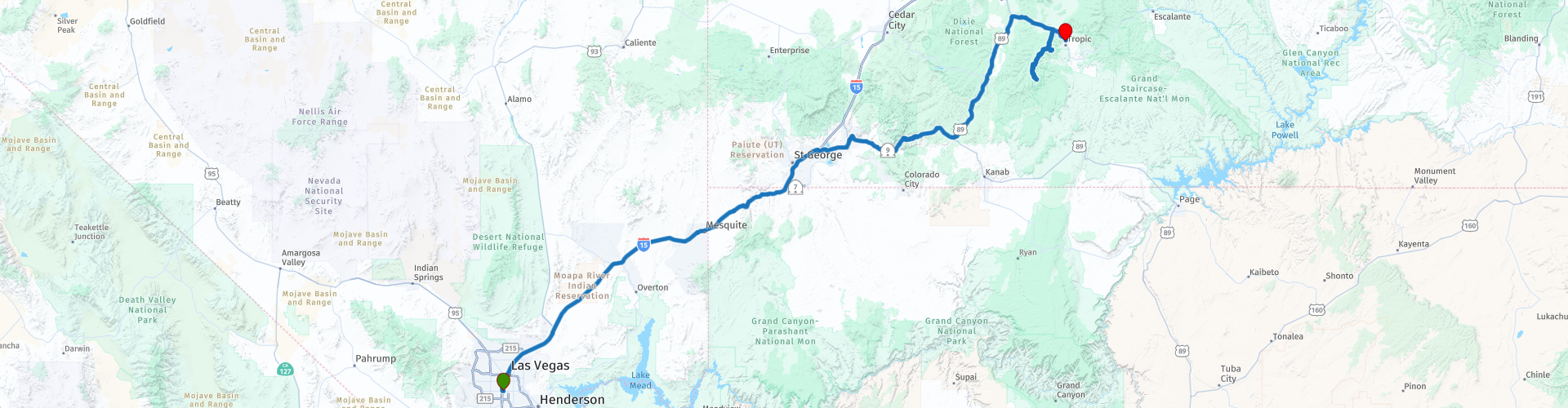
Day 05 Las Vegas to Tropic trough Zion and Red Canyon National Parks

This route was brought to you by:
RouteXpert Paul Hedges - Adv RouteXpert
Last edit: 16-01-2022
 Route Summary
 We will be passing through 2 of the most stunning National Parks America has to offer while travelling along a freeway that is actually listed as a Scenic Byway. The day starts in the desert of Nevada and ends in mountains of Utah taking in 2 national parks along the way.
Enjoy all the scenery and great roads this 4 star day has to offer
 Share this route


Animation

Verdict


Duration
9h 50m

Mode of travel
Car or motorcycle

Distance
493.14 km

Countries

 RouteXpert Review
 Like all days we start with a full fuel tank!
Heading out of Las Vegas the freeway soon brings a stark change of surrounds, the cityscape is soon replaced with a wide open plain that seems to be surrounded by mountains in the distance.
After a break in Mesquite we cross the border into Arizona (RP6) this is our first time zone change, Nevada is on Pacific Standard Time, Arizona is on Nevada/Arizona Border and 1 hour ahead so time to adjust your time pieces.
Now freeways do not usually qualify as scenic routes, but I-15 (also called Veterans Memorial Highway) is an outstanding exception. as you travel along the Virgin River Scenic Highway (RP7) there is a transition from Mojave Desert to Colorado Plateau, passing through the spectacular Virgin River Gorge along the way.
Soon the visit to Arizona is over and you enter Utah (RP9) and get off the freeway at St George.
The Zion Park Scenic Byway traverses beautiful red rock scenery along the Virgin River from the town of Hurricane into Zion National Park. Entrance Fee (Jan 2022) Private Vehicle $25 Motorcycle $12 each for 7 day passes. Highlights include swirling, otherworldly rock formations, mounds, towers, hoodoos, and hilltops. Layered strata of rusty red, orange, cream, yellow and brown colour the landscape that is dotted with desert pines, sagebrush, and wildflowers. As you travel through the park you'll pass through a major Utah historical attraction, the famous Zion–Mt. Carmel Tunnel, constructed in the 1920s and still impressive to behold today. The tunnel is over 5,000 feet long and rather narrow, making it a just-barely fit for regular passenger cars in two-way traffic. The Zion–Mt. Carmel Tunnel does include many windows so passengers can get a brief glimpse of the scenery outside the tunnel’s enclosure — but there is no stopping, and no bicycles, permitted in the tunnel. There are many stopping points along the route to pull off and take pictures of the many rock formations. Checkerboard Mesa is an exceptionally unique one with a crisscross pattern baked right into it. You can make a two-mile hike to it, or just pause from the drive-up overlook (RP18)
Leaving the park, it is time for refreshments at Carmel Junction (RP19) before Route 89 takes us up to Red Canyon through the Dixie National Forest.
The Red Canyon Visitor Center (RP23) is open daily: Monday - Friday 10am - 5pm, Saturday - Sunday 9am - 6pm. It sits on the southern rim of the Red Canyon above the Flaming Gorge Reservoir overlooking a stunning view into the 1,631 foot canyon. Because Red Canyon is part of the Dixie National Forest, rather than a national park or monument, there is no fee to enter the canyon, following the road will also lead you to 2 road arches (RP 24/25) cut into the rock in the 1920s.
Our second national park of the day is the Bryce Canyon National Park, a sprawling reserve in southern Utah, known for crimson-coloured hoodoos, which are spire-shaped rock formations. Entrance fees per vehicle £35, per motorcycle $30 (Jan 2022) The park’s main road leads past the expansive Bryce Amphitheater, a hoodoo-filled depression lying below the Rim Trail hiking path. It has many overlooks including Fairview Point (RP35), Swamp Canyon Overlook and Bryce Point (RP37). Prime viewing times are around sunrise and sunset. Bryce Canyon first became a tourist destination in 1916 with Union Pacific. It was then declared a National Monument in 1923, and officially established as a National Park in 1928.
We finish the day in a log cabin in Tropic, worlds away from the hustle and bustle of Las Vegas the night before. Be prepared for big dark skies and the opportunity to enjoy some late-night star gazing.


 Links
Links  Usage
Usage Want to download this route?
You can download the route for free without MyRoute-app account. To do so, open the route and click 'save as'. Want to edit this route?
No problem, start by opening the route. Follow the tutorial and create your personal MyRoute-app account. After registration, your trial starts automatically.  Disclaimer
Use of this GPS route is at your own expense and risk. The route has been carefully composed and checked by a MyRoute-app accredited RouteXpert for use on TomTom, Garmin and MyRoute-app Navigation.
Changes may nevertheless have occurred due to changed circumstances, road diversions or seasonal closures. We therefore recommend checking each route before use.
Preferably use the route track in your navigation system. More information about the use of MyRoute-app can be found on the website under 'Community' or 'Academy'.

Utah
About this region
Utah ( YOO-tah, YOO-taw) is a state in the Mountain West subregion of the Western United States. It is bordered by Colorado to the east, Wyoming to the northeast, Idaho to the north, Arizona to the south and Nevada to the west. It also touches a corner of New Mexico in the southeast. Of the fifty U.S. states, Utah is the 13th-largest by area; with a population over three million, it is the 30th-most-populous and 11th-least-densely populated. Urban development is mostly concentrated in two areas: the Wasatch Front in the north-central part of the state, which is home to roughly two-thirds of the population and includes the capital city, Salt Lake City; and Washington County in the southwest, with more than 170,000 residents. Most of the western half of Utah lies in the Great Basin.
Utah has been inhabited for thousands of years by various indigenous groups such as the ancient Puebloans, Navajo and Ute. The Spanish were the first Europeans to arrive in the mid-16th century, though the region's difficult geography and harsh climate made it a peripheral part of New Spain and later Mexico. Even while it was Mexican territory, many of Utah's earliest settlers were American, particularly Mormons fleeing marginalization and persecution from the United States. Following the Mexican–American War in 1848, the region was annexed by the U.S., becoming part of the Utah Territory, which included what is now Colorado and Nevada. Disputes between the dominant Mormon community and the federal government delayed Utah's admission as a state; only after the outlawing of polygamy was it admitted in 1896 as the 45th.
Slightly over half of all Utahns are Mormons, the vast majority of whom are members of The Church of Jesus Christ of Latter-day Saints (LDS Church), which has its world headquarters in Salt Lake City; Utah is the only state where a majority of the population belongs to a single church. The LDS Church greatly influences Utahn culture, politics, and daily life, though since the 1990s the state has become more religiously diverse as well as secular.
Utah has a highly diversified economy, with major sectors including transportation, education, information technology and research, government services, mining, and tourism. Utah has been one of the fastest growing states since 2000, with the 2020 U.S. Census confirming the fastest population growth in the nation since 2010. St. George was the fastest-growing metropolitan area in the United States from 2000 to 2005. Utah ranks among the overall best states in metrics such as healthcare, governance, education, and infrastructure. It has the 14th-highest median average income and the least income inequality of any U.S. state. A 2012 Gallup national survey found Utah overall to be the "best state to live in the future" based on 13 forward-looking measurements including various economic, lifestyle, and health-related outlook metrics.
Read more on Wikipedia
Utah has been inhabited for thousands of years by various indigenous groups such as the ancient Puebloans, Navajo and Ute. The Spanish were the first Europeans to arrive in the mid-16th century, though the region's difficult geography and harsh climate made it a peripheral part of New Spain and later Mexico. Even while it was Mexican territory, many of Utah's earliest settlers were American, particularly Mormons fleeing marginalization and persecution from the United States. Following the Mexican–American War in 1848, the region was annexed by the U.S., becoming part of the Utah Territory, which included what is now Colorado and Nevada. Disputes between the dominant Mormon community and the federal government delayed Utah's admission as a state; only after the outlawing of polygamy was it admitted in 1896 as the 45th.
Slightly over half of all Utahns are Mormons, the vast majority of whom are members of The Church of Jesus Christ of Latter-day Saints (LDS Church), which has its world headquarters in Salt Lake City; Utah is the only state where a majority of the population belongs to a single church. The LDS Church greatly influences Utahn culture, politics, and daily life, though since the 1990s the state has become more religiously diverse as well as secular.
Utah has a highly diversified economy, with major sectors including transportation, education, information technology and research, government services, mining, and tourism. Utah has been one of the fastest growing states since 2000, with the 2020 U.S. Census confirming the fastest population growth in the nation since 2010. St. George was the fastest-growing metropolitan area in the United States from 2000 to 2005. Utah ranks among the overall best states in metrics such as healthcare, governance, education, and infrastructure. It has the 14th-highest median average income and the least income inequality of any U.S. state. A 2012 Gallup national survey found Utah overall to be the "best state to live in the future" based on 13 forward-looking measurements including various economic, lifestyle, and health-related outlook metrics.
View region
 Statistics
  19
19Amount of RX reviews (Utah)
 14065
14065Amount of visitors (Utah)
 410
410Amount of downloads (Utah)
 Route Collections in this region
 Car or motorcycle tour through the western US
This collection contains all 15 routes driven by MRA Goldmember André ter Schegget during his three-week tour through the west of America.
The places to visit, the attractions and beautiful photo spots are nicely marked on the routes. The routes have been fully checked and made equal for the Garmin and the TomTom. Enjoy this wonderful trip and let us know how it was! Enjoy and stay safe!
Order of the tour:
Route 01: from Los Angeles and via Pacific Coast Highway to Solvang
Route 02: Solvang to Monterey / Pacific Grove
Route 03A: Monterey to San Francisco
Route 03B: if you are by car instead of the motorcycle, as motorcycles are not allowed on the 17 Mile Drive: from Monterey to the 17 Mile Drive and further to San Francisco
Route 04: from San Francisco via Nappa and Eldorado National Forrest to Topaz Lake
Route 05: from Topaz Lake via Bodie and Yosemite to Oakhurst
Route 06: from Oakhurst via Kings Canyon NP and Sequoia NP and Giant Forest to Exeter
Route 07: Exeter via Isabella Lake and Ridgecrest to Death Valley
Route 08: from Death Valley via Valley Of Fire to Mesquite
Route 09: from Mesquite via Zion NP and Dixie NF to Hatch
Route 10: Hatch via Bryce Canyon to Page
Route 11: from Page via Grand Canyon to Williams
Route 12: from Williams via Seligman and Route 66 to Kingman and via Hoover Dam to Las Vegas
Route 13: from Las Vegas via Oatman and Lake Havasu to Parker
Route 14: from Parker via Joshua Tree to Rancho Mirage
Route 15: Rancho Mirage via Palm Springs to Santa Monica
View Route Collection
Top car and motorcycle tour through the west of the USA
By car or motorcycle through the West of America is a journey that you do not just make, so also not driving 15 days and then back home. No, book a stay of several days in Los Angeles, Las Vegas, San Francisco and again Los Angeles to also visit several places of interest in these cities, so that this tour becomes an unforgettable tour that you can remember with pleasure.
Do not forget to arrange and pack the following items:
*This is only a summary and completely personal and may differ per person.
Take out travel insurance, +31 for numbers in GSM, (partially) take out gas, Health insurance coverage at destination?, Switch off electrical appliances, Lighting (time clock), Check passport validity, Antenna from radio/TV due to lightning, Residence address for those left behind, Remote control house alarm, Book Smart Parking.
Hand luggage:
Liquids in packaging of max. 100 ml, Liquids in hand luggage in transparent plastic bag.
For on the road:
Candy, Book, Earplugs, Country and road map(s), Directions, Maps in your navigation system
Money & Securities:
Bank card / giro card, Credit card (think pin code), Cash, Calculator for Internet banking, Medical insurance card, Travel insurance card.
Travel documents:
Passport, (International) Driver's License, Ticket(s), Reservation Tickets, Hotel Vouchers, Arrival/Departure Time, Check-in & Check-out Times, Valid Visa (ESTA), Travel Guide.
Clothing:
Underwear, Belt, Shirts/ T-shirts, Shorts, Long pants, Shoes, Socks, Swim trunks, Towel, Slippers.
Personal stuff:
Watch, House Keys, Wallet, Sunglasses.
Toiletries:
Deodorant, Shower gel / Soap, Comb / brush, Shaving equipment, Shampoo, Toothbrush, Toothpaste, Sanitary pads
Health & Medicine:
Own medicines, Insect repellent, Cold sore ointment, Ointment for insect bites, Sunscreen, Norit, Paracetamol, Suction cup for insect bites, First aid bag.
Miscellaneous:
Travel bag / waist bag, Leatherman (= checked luggage), Pen or pencil, Headlamp, Lighter, Tools & Electronics, Mobile phone & charger, Photo/video camera & charger, Memory card(s), World plug / adapter, Ipod & charger, Adapter cable Ipod, Headphones, iPad & charger, Navigation & charger/plug, Plug socket, Fuelpack battery.
Engine (accessories):
Helmet, Motorcycle clothing, Motorcycle boots, Chain lock / disc brake lock, Gloves, Bandana, Inner bags (plastic shopping bag), Insulation bag, Tension straps, Tie wraps, Rain suit, Rainaway.
Addresses:
Address list, Embassy telephone number, Telephone number to block (bank) card(s), Telephone number (airline tickets).
View Route Collection