Round trip from Oviedo 3 Picos de Europa

This route was brought to you by:
RouteXpert Nick Carthew - (MRA Master)
Last edit: 23-06-2022
 Route Summary
  Share this route


Animation

Verdict


Duration
9h 49m

Mode of travel
Car or motorcycle

Distance
346.55 km

Countries

 RouteXpert Review
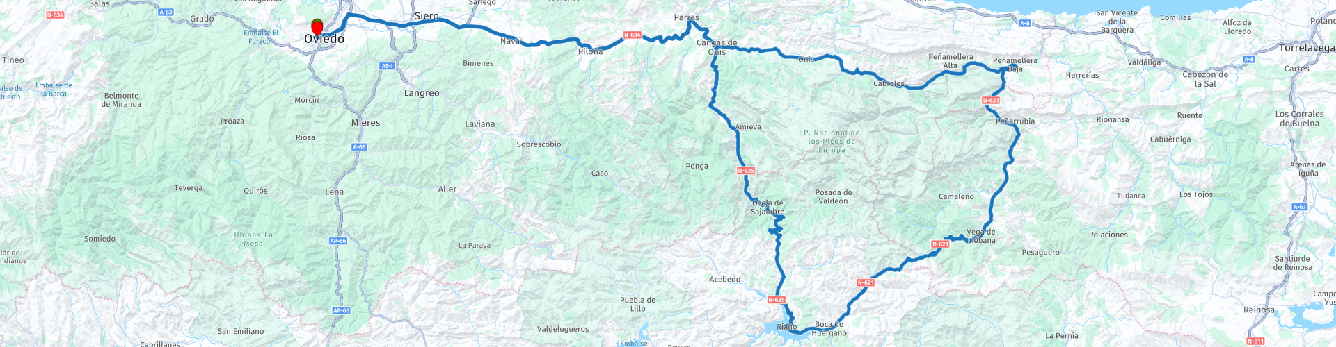
 This route heads east to the popular biker paradise of Picos de Europa National Park. A short section of motorway and then the N-634 which has plenty of curves to keep you happy will have you in the Picos in one hour. The town of Cangas de Onís greets you with it's magnificent Roman bridge and offers your first of many photo opportunities and coffee stops. The route circumnavigates the national park from here and you will return here after about 200 kms (4-5 hrs) of the most memorable scenery.
Take the N-625 from Cangas, possibly the most scenic road in the Picos. Follow the River Sella against it's flow and feel the road becoming more twisty and the river valley turning into a gorge. There's an restaurant for another coffee stop at the start of the Beyos Gorge (Desfiladero de los Beyos in Spanish). The Beyos Gorge is a deep and narrow 12 km long river canyon through which the waters of the Sella River flow. Whoever drives along this exceptional road will surely share the famous words of the French scientist and mountaineer Paul Labrouche and eternalised on the stone plaque that can be seen on the other side of the bridge at this restaurant, it reads:
“The Sella gorge is the steepest and most imposing of the famous gorges. Pierre Lys et Saint-Georges, in the Aude Pyrenees, the Fier, in Savoy and the Via Mala, in the Grisons. The Chiffa, in the Atlas, the Crack of Khakoueta, in the Soude valley, and the Calle del Infierno, in the Lys, can only give, in a very small way, the image of the fantastic notch in which the Castilian engineers managed to make a road pass." I think those words say far more than I can, suffice to say; the Desfiladero de los Beyos is a truly remarkable road.
There's a viewpoint at the other end of the gorge called Mirador de Oseja de Sajambre, I strongly advise you to stop here for more photos.
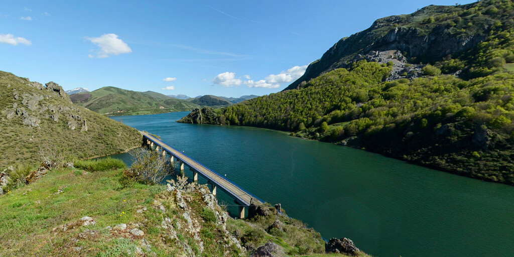
Next is a famous climb that cyclists like to collect, the Puerto del Pontón, featured many times in the Vuelta a España. A short ride from here takes you to the sparkling waters of the Riano Reservoir. The construction of the reservoir began in 1965, although certain social and political circumstances delayed its opening until late 80. A great place to stop for photos is at Riano. On a still day the mountain backdrop is reflected perfectly in the blue water.
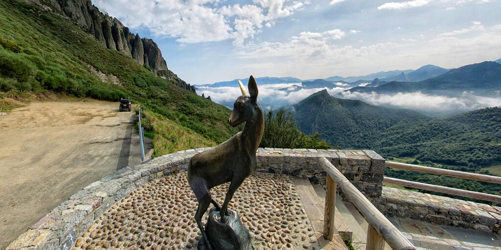
The road number changes to the N-621 as you head in a north east direction. The tight and twisty nature of the gorge road has been exchanged for an equally twisty but more open road that is a joy to ride. 29 kms later and you'll climb to the highest point of this route, Puerto de San Glorio at 1609m. You can take a left turn here and climb even higher to the Collado de Llesba mountain pass and see the monument to the Cantabrian Brown Bear at 1675m. The Collado de Llesba is a place frequented by many visitors because of the exceptional viewpoint towards the eastern and central massifs of the Picos de Europa.
Next is perhaps the most photographed viewpoint of the San Glorio Pass and features in many publications advertising the Picos. It the very cute Roe Deer on the hairpin bend known as Mirador del Corzo. There's plenty of safe space to park for your own photo.
The next 23 kms is a mixture of landscapes, that include mountain roads with steep drop offs, a shallow gorge, woody areas and alpine pastures all on a twisty road with several hairpin bends - sounds like heaven doesn't it! This is why the Picos de Europa is popular.
My suggestion for a lunch stop is at Potes.
Potes is one of the most attractive villages in Cantabria. The village is in the centre of the historic Liébana region, an area that is surrounded by spectacular mountains, with running streams and rivers. Its old quarter has the Property of Cultural Interest designation. It streets have many bridges, as well as buildings and monuments with centuries of history. Make sure you sample the village cuisine, with dishes such as cocido lebaniego (chickpea casserole) and game stews. There are also many shops selling Picos de Europa souvenirs but I'm sure that your memories will serve as a reminder of this beautiful area.
After lunch the route travels through another deep gorge, this time carved out by the River Deva and known as the Herminda Gorge. A pull-in at the side of the road offers a safe place to stop for a photo. There is a walk from here called the Ruta de las Agüeras that offers some great views of the gorge. It takes about 3-4 hours.
The small hamlet of Panes is where you'll leave the N-621 and join the AS-114 as you head back towards Cangas de Onis.
The AS-114 is not a challenging road but the scenery is still beautiful.
When you reach Cangas de Onis, take a left opposite the plaza then two more to bring you to the motorcycle parking. Here you can have your photo taken on the Fred Flintstone motorcycle. It weighs 2,500 kilos and is made of two mill wheels and river stones, with a solid steel chassis. The inscription on the plinth of the motorcycle reads: Aqui Comienza Todo Un Paraiso De Curvas which translates as: Here begins a whole paradise of curves!
The idea behind it was to welcome the thousands of bikers that enjoy this area with a hope that they will stop for a photo then enjoy a coffee in the plaza. I urge you to do this before heading back to Oviedo, about 1 hour away.
Enjoy
 Links
Links  Usage
Usage Want to download this route?
You can download the route for free without MyRoute-app account. To do so, open the route and click 'save as'. Want to edit this route?
No problem, start by opening the route. Follow the tutorial and create your personal MyRoute-app account. After registration, your trial starts automatically.  Disclaimer
Use of this GPS route is at your own expense and risk. The route has been carefully composed and checked by a MyRoute-app accredited RouteXpert for use on TomTom, Garmin and MyRoute-app Navigation.
Changes may nevertheless have occurred due to changed circumstances, road diversions or seasonal closures. We therefore recommend checking each route before use.
Preferably use the route track in your navigation system. More information about the use of MyRoute-app can be found on the website under 'Community' or 'Academy'.

Asturias
About this region
Asturias (, Spanish: [asˈtuɾjas]; Asturian: Asturies [asˈtuɾjes; -ɾjɪs]), officially the Principality of Asturias (Spanish: Principado de Asturias; Asturian: Principáu d'Asturies; Galician-Asturian: Principao d'Asturias), is an autonomous community in northwest Spain.
It is coextensive with the province of Asturias and contains some of the territory that was part of the larger Kingdom of Asturias in the Middle Ages. Divided into eight comarcas (counties), the autonomous community of Asturias is bordered by Cantabria to the east, by León (Castile and León) to the south, by Lugo (Galicia) to the west, and by the Cantabrian sea to the north.
Asturias is situated in a mountainous setting with vast greenery and lush vegetation, making it part of Green Spain. The region has a maritime climate. It receives plenty of annual rainfall and little sunshine by Spanish standards and has very moderated seasons, most often averaging in the lower 20s celsius. Heatwaves are rare due to mountains blocking southerly winds. Winters are very mild for the latitude, especially near sea level.
The most important cities are the communal capital, Oviedo, the seaport and largest city Gijón, and the industrial town of Avilés. Other municipalities in Asturias include Cangas de Onís, Cangas del Narcea, Gozón, Grado, Langreo, Llanera, Laviana, Lena, Llanes, Mieres, Siero, Valdés, Vegadeo and Villaviciosa (see also List of municipalities and comarcas in Asturias).
Asturias is also home of the Princess of Asturias Awards.
Read more on Wikipedia
It is coextensive with the province of Asturias and contains some of the territory that was part of the larger Kingdom of Asturias in the Middle Ages. Divided into eight comarcas (counties), the autonomous community of Asturias is bordered by Cantabria to the east, by León (Castile and León) to the south, by Lugo (Galicia) to the west, and by the Cantabrian sea to the north.
Asturias is situated in a mountainous setting with vast greenery and lush vegetation, making it part of Green Spain. The region has a maritime climate. It receives plenty of annual rainfall and little sunshine by Spanish standards and has very moderated seasons, most often averaging in the lower 20s celsius. Heatwaves are rare due to mountains blocking southerly winds. Winters are very mild for the latitude, especially near sea level.
The most important cities are the communal capital, Oviedo, the seaport and largest city Gijón, and the industrial town of Avilés. Other municipalities in Asturias include Cangas de Onís, Cangas del Narcea, Gozón, Grado, Langreo, Llanera, Laviana, Lena, Llanes, Mieres, Siero, Valdés, Vegadeo and Villaviciosa (see also List of municipalities and comarcas in Asturias).
Asturias is also home of the Princess of Asturias Awards.
View region
 Statistics
  17
17Amount of RX reviews (Asturias)
 17522
17522Amount of visitors (Asturias)
 1454
1454Amount of downloads (Asturias)
 Route Collections in this region
 Three tours in and around Picos de Europa Northern Spain
The Picos de Europa is a mountainous area in northern Spain, next to the Basque Country. In the middle is the village of Posada de Valdeon, which cannot be reached by motorbike from the north: you have to drive around the Picos via Potes or Sames. We stayed overnight in Posada de Valdeon in Hostal Casa Abascal. A great hotel with breakfast option. You can eat in a restaurant in the village with usually a choice of two menus.
There are all kinds of nature reserves around the Picos. These three routes take you through some of them. There are gorges to see, viewpoints, reservoirs and you can walk more than fine. If you like walking, bring your walking shoes.
But we come to ride and it's going great. Excellent roads with the occasional piece of unpaved so that you do not have to detour far for another attraction. You can eat delicious food and the people are very nice and hospitable. And because the route to Lourdes goes above the Picos, there are also pilgrimage sites and very beautiful churches and monasteries. The most beautiful thing in this area is the nature: breathtakingly beautiful with wild animals, rugged mountains and wild rivers.
All in all, you can spend at least 4 days here if you take a day of rest or go for a walk.
View Route Collection
Ten Day Roadtrip from Spain to Portugal
This route collection describes a 10-day Road trip in the north of Spain and Portugal, a true paradise for motorcycling.
You drive over beautiful mountain ridges and through beautiful valleys. Along the way you drive through beautiful villages and countless nature reserves, great passes with countless curves, tunnels cut out of the mountains and azure blue reservoirs. The roads are fair to good, sometimes unpaved.
What you get to see along the way;
Spanish Pyrenees
Parc Naturel del Cadi-Moixero
Serra del Cadí
Serra de Moixeró
Pedraforca
Serra del Monsec
Collada de Clarà
Parque Nacional de Ordesa y Monte Perdido
Collados del Asón Natural Park.
Parque natural Saja-Besaya
Parque natural de Fuentes Carrionas y Fuente Cobre
Parque natural de la Montana de Riano y Mampodre
Picos de Europa
El Parque regional Montaña de Riaño y Mampodre
El Parque natural de Redes
The Sierra de la Culebra
Parque natural Montesinho
Along the routes there are more than enough nice places to stop for a short or longer period, these are described in the review and with a waypoint and POI included in the routes.
Have fun reading and planning your next motorcycle vacation.
If you have ridden these routes I would like to hear your feedback.
View Route Collection