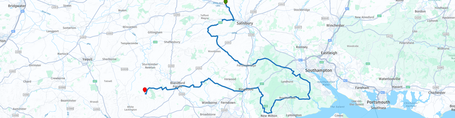
03 Stapleford to Higher Ansty via the New Forest National Park

This route was brought to you by:
RouteXpert Nick Carthew - (MRA Master)
Last edit: 20-09-2022
 Route Summary
 A visit to the New Forest National Park and the Sammy Miller Motorcycle Museum using rural roads and visiting some top class attractions. The beautiful landscape, good attractions and roads earn this route 4**** stars
 Share this route


Animation

Verdict


Duration
6h 40m

Mode of travel
Car or motorcycle

Distance
169.86 km

Countries

 RouteXpert Review
 Starting off from the within Cranborne Chase and West Wiltshire Downs AONB (Area of Outstanding Natural Beauty) and heading towards The New Forest National Park, you know that this is going to be a great route.
Just minutes after leaving the Pelican Inn, you will pass the gates of Wilton House, home to the 18th Earl and Countess of Pembroke. Built on the site of a 9th century nunnery but now set in 21 acres of landscaped parkland, with water and rose gardens beside the River Nadder. It has been the family’s home for over 450 years.
A few miles on and you will see hillside chalk carvings, these are known as The Fovant Badges. The first is an outline of the country of Australia then half a mile further are the main group. Thousands of soldiers were stationed in training camps near to the village of Fovant, during the 1914-1918 war. In memory of those who died on the battlefields, many regiments created replica cap badges on the adjacent chalk downs by turf cutting and infilling with chalk. Although many badges have not survived, several were recently restored and are now Scheduled Ancient Monuments.
The second watercress farm of this tour is next and you'll pass right through the middle of it. It is said to have been the staple diet of roman soldiers, the poor man’s food of the Victorian time; watercress was munched from a paper cone in the streets making it one of the first fast foods but more importantly an early superfood. Gram for gram watercress contains more vitamin C than oranges, more vitamin E than Broccoli, more calcium than cow’s milk and more folate than bananas, it also contains iron and beta carotene.
Enjoy the next few miles of virtually traffic free rural roads through the rich and fertile countryside to Fordingbridge where I have suggested stopping for a coffee beside the beautiful River Avon. The George Inn sits next to the medieval bridge with its seven graceful arches that span the river. The New Forest National Park starts on the other side of the river.
The New Forest National Park is a scenic area with heathlands, forests and not forgetting the wild New Forest Ponies. Whist meandering through the area you can often spot cows, pigs, donkeys and of course the ponies roaming free. A speed limit of 40mph (64kph) exists on all of the roads that you will use in the New Forest. Created in 2005, the New Forest National Park is one of the UK’s newest National Parks, although the New Forest was established in 1079 when William the Conqueror named the area his ‘new hunting forest’; little could he imagine that nearly 1,000 years later his ‘Nova Foresta’ would still retain its mystery and romance.
The route travels past the National Motor Museum Beaulieu. It's a great museum but if you wish to visit the Sammy Miller Motorcycle Museum later in this route, you probably won't have time for this one. The National Motor Museum Beaulieu has many exhibits here and you'll need 4-5 hours to see them all. The choice is yours, 4 wheels now or two wheels just 14 miles from here.
I have suggested a lunch stop at the Sammy Miller Motorcycle Museum.
Sammy Miller MBE is a motorcycling legend. 11 times British Champion and winner of over 1400 events, with a racing career spanning more than 50 years! The Museum houses one of the finest collections of fully restored motorcycles in the world, including factory racers and exotic prototypes, with the collection constantly evolving as new bikes are acquired. This is a living museum with almost every motorcycle in the museum in full running order. Sammy demonstrates and parades bikes throughout the year.
A short section of the A31 dual carriageway takes you away from the New Forest and across the county border into Dorset, one of the counties that make up the West Country (SW England). You are soon back into the beautiful countryside of the Cranborne Chase and West Wiltshire Downs AONB as you head further west.
Some of the things to look out for are:
Horton's Tower:
You'll see this on your left just before the village of Horton. Said to have once been the tallest non-religious building in Britain. The strange looking Horton's Tower is a classic example of a folly - A folly is a building built mainly for decoration - an eye-catcher for the rich to admire from their property. They were hugely popular in the 18th and 19th centuries. Horton's Tower was built in 1726 by Humphrey Sturt to watch and follow the local hunt when he was too old to ride. Made from red brick, the tower stands at 140ft tall.
Avenue of Trees:
There is a beautiful avenue of beech trees to ride under as you approach Crichel House, one of Dorset’s old manor houses, the estate dating back to medieval times. The current house dates only from the mid 18th century after the previous house was destroyed by fire, but it is an estate with a past that includes the moving of the original village to allow for an extension of the grounds.
RAF Tarrant Rushton Airfield Memorial:
Sat at the side of the road on a sharp bend is what looks like an insignificant memorial; nothing could be further from the truth. RAF Tarrant Rushton Memorial. Around 11pm on 5 June 1944, six Halifax aircraft took off from RAF Tarrant Rushton, each towing a Horsa glider carrying British troops of 2nd Battalion, Oxfordshire and Buckinghamshire Light Infantry (part of 6th Airborne Division). Little more than an hour later, men from these gliders seized two bridges on the eastern flank of the Allied landings in Normandy – later known as Pegasus Bridge and Horsa Bridge respectively. They were the first Allied troops to land in Normandy.
Fill up with fuel for tomorrow when you reach the town of Blandford Forum as there are not many fuel stations at the start of the next route in this tour.
The final stop for the day is at Bulbarrow Hill:
Bulbarrow Hill, probably the best known hill in Dorset and is a chalk hill site of an Iron Age hill fort - the name comes from barrows or burial mounds on the hill. Standing at 274m (899ft) high and giving the longest view in Dorset, with spectacular views over five counties, Bulbarrow Hill is the second highest point in Dorset and is a very popular beauty spot.
From here the end of the route and tonight's accommodation at Pleck Barn is just 5 minutes away.
Pleck Barn is a old fashioned farmhouse B&B.
Enjoy.


 Links
Links  Usage
Usage Want to download this route?
You can download the route for free without MyRoute-app account. To do so, open the route and click 'save as'. Want to edit this route?
No problem, start by opening the route. Follow the tutorial and create your personal MyRoute-app account. After registration, your trial starts automatically.  Disclaimer
Use of this GPS route is at your own expense and risk. The route has been carefully composed and checked by a MyRoute-app accredited RouteXpert for use on TomTom, Garmin and MyRoute-app Navigation.
Changes may nevertheless have occurred due to changed circumstances, road diversions or seasonal closures. We therefore recommend checking each route before use.
Preferably use the route track in your navigation system. More information about the use of MyRoute-app can be found on the website under 'Community' or 'Academy'.

South East
About this region
The points of the compass are an evenly spaced set of horizontal directions (or azimuths) used in navigation and geography. A compass rose is primarily composed of four cardinal directions—north, east, south, and west—each separated by 90 degrees, and secondarily divided by four ordinal (intercardinal) directions—northeast, southeast, southwest, and northwest—each located halfway between two cardinal directions. Some disciplines such as meteorology and navigation further divide the compass with additional azimuths. Within European tradition, a fully defined compass has 32 'points' (and any finer subdivisions are described in fractions of points).Compass points are valuable in that they allow a user to refer to a specific azimuth in a colloquial fashion, without having to compute or remember degrees.
Read more on Wikipedia
View region
 Statistics
  21
21Amount of RX reviews (South East)
 19454
19454Amount of visitors (South East)
 1805
1805Amount of downloads (South East)
 Route Collections in this region
 8 beautiful routes through England
"8 beautiful routes through England"
You may have seen one of these routes pass by. Eight routes have been driven and made in 2018.The routes are part of a 9-day trip through England. You drive through landscapes that are varied and beautiful. You can see beautiful rolling hilly vistas.
The main roads are of reasonable to good quality, but you also drive on roads that are less maintained and there may be some gravel on the roads here and there.
In general, they are beautiful routes through a beautiful country. The routes are connecting and turn left around London. The start and end points of the routes are Hull.
The collection contains the following routes;
Day 1 from Hull to Ashbourne (224 km)
Day 2 from Ashbourne to Birdlip (245 km)
Day 3 from Birdlip to Feldbridge (295 km)
Day 4 from Feldbridge to Whitstable (250 km)
Day 5 from Whitstable to Colchester (227 km)
Day 6 from Colchester to Hinckley (233 km)
Day 7 Tour and visit Triumph Factory and National Motorcycle Museum (77 km)
Day 8 from Hinckley to Hull (262 km)
All routes have been checked and leveled for Tomtom, Garmin and MyRoute-App Navigation. The routes follow the original route as they were made at the time.
Have fun driving one of these routes. Enjoy all the beauty that England has to offer, such as; The Clumberpark, Bolsover Castle, The Seven Sisters, The White Ciffs of Dover. Of course, a visit to the Triuph factory and the National Motorcycle Museum is also highly recommended.
View Route Collection
A collection of routes covering East England including Hull Scarborough Newmarket Colchester Orpington and Folkestone
East England has a host of great roads to travel and many historical sites to visit.
The picture above shows the North York Moors National Park in all of it's glory with the heather in full bloom. This collection of routes covers as far north as Lindisfarne and as far south as Folkestone, they all travel through varied landscapes from high moorland to the level fens and everything in between. There is something for everyone in this collection. There is also a mini 2 day tour down the east coast from Hull to the Eurotunnel for those that want to enjoy the journey south before heading into Europe, this of course can be joined from anywhere along the way.
As with all MyRoute-app RouteXpert routes, these have been made equal for MRA Navigation, TomTom and Garmin devices meaning that whatever GPS satnav you use, you and all of your travelling companions are guaranteed to follow these routes precisely. Enjoy.
View Route Collection