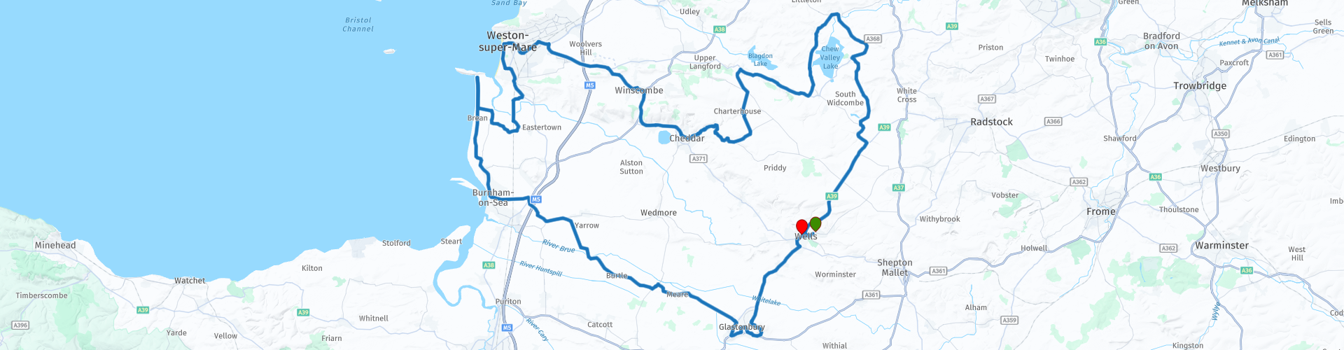
Round tour from Wells Via Glastonbury Cheddar Gorge and Mendip Hills

This route was brought to you by:
RouteXpert Paul Taylor
Last edit: 19-09-2023
 Route Summary
 This route definitely deserves a 5***** stars because the roads, scenery and attractions are all Excellent.
 Share this route


Animation

Verdict


Duration
8h 22m

Mode of travel
Car or motorcycle

Distance
137.27 km

Countries

 RouteXpert Review
 Leaving Wells behind and after only a short distance of approximately 5 miles we soon arrive at Glastonbury Tor a hill near Glastonbury but still in the Mendip region, it is known as being one of the most spiritual sites in the country, with its steep climb up to 158 meters, topped by the roofless St Michael's Tower, a Grade I listed building and offers some spectacular views at the top overlooking the Mendip Hills. A stones throw away nestled between the two hills (Mother Earth), Tor and Chalice lay the sacred 2000 year old mystical chalice well also known as the white Spring called this because of its rich calcite content originating from the limestone. If you cross the road is the Red Spring it is called this because of its rich iron content that colours the water red and leads to many of the adventurous myths that surround the Chalice Well site, including that of Joseph of Arimathea visiting and burying the two cruets containing the blood and water from Christ’s wounds. On the opposite side of the very narrow road, you will find the white Spring so called because of its rich calcite content originating from the limestone. It is then onto Glastonbury town with its historic Abbey founded in the 8th century and enlarged in the 10th now a grade I listed building and scheduled ancient monument. Whilst here you can browse the unique shops selling traditional spiritual items like crystals, esoteric books, witchcraft supplies and faery accessories. There is plenty of parking at all the sites in and around Glastonbury, I can highly recommend the bakery “Burns the Bread” just near the Town Hall has a huge selection of breads and sweet delights to offer.
Taking the B3151 out of Glastonbury there is a route option to take the next right to visit the Meare Fish House the only surviving monastic fishery building left in England, it was the residence of Glastonbury Abbey's official in charge of the nearby lake and its fishery, and it provided facilities for fish-salting and drying. Now owned and run by English Heritage with free entry and off-street parking down a dirt lane . From here continue towards the B3139 where you leave the Mendip region but are still inside the county of Somerset, you have another route option before coming of the B3139 continue straight, if you want to visit a traditional Somerset Cider family business, Rich's Cider Farm, where you can sample and purchase pressed Somerset apples cider from the farm shop, there is also a restaurant on site offering ample free parking. You are now heading towards the coast for a stop at Brean Downs café for refreshments and lunch, the café is run and owned by the National Trust , there is parking which accommodates a few motorbikes in the located spaces provided. It is a little bit of a walk from here, but there is an option to take the path up to the 18th century Brean Down Hill Fort built 18m above sea level to defend the country against a possible Napoleonic invasion. In the distance on a clear day, you can see the island of Steep Holm sitting perched proud in the Bristol Channel. Leaving Brean Down we head up the coast to Weston Super Mare, care should be taken here as the roads are very narrow and winding until the A370 and after this into Weston the road into Weston have previously been recorded as a high accident black spot. Once in Weston it was not until the 19th century that saw it grow from a tiny village of about 100 inhabitants, to a thriving Victorian seaside resort and the home of two piers, the Birnbeck Pier which was completed in 1867 and the Grand Pier that open in 1904.
Taking the A371 out of Weston we pass the 18th century Banwell Castle currently a B&B on the right if you are looking for overnight accommodation. Still heading towards Cheddar another route option is to turn off into Axbridge and stop to visit King Johns early Tudor timber framed hunting Lodge. This is now run as a museum owned by the National Trust with a ridiculously small entrance fee, there is parking 100yds away that is not free or alternatively there is one further down the road, just off Old Church Road that is free (Do check opening times). Leaving here, you are soon in the village of Cheddar renowned for being a motorcycling hot spot and for its world-famous Cheddar Cheese, where you can see how Cheddar Cheese is made in the traditional way, plus you have the option to try and buy different varieties from the shop. But most importantly Cheddar is famously known as where Britain's oldest complete human skeleton was found in 1903, the Cheddar Man estimated to be 9,000 years old so well worth a visit. There is plenty of paid parking in the village or alternatively just as you head out there is free parking on the sides of the road.
As you leave Cheddar Village you go through Cheddar Gorge a 3-mile ride of limestone awe-inspiring cliffs rising up approximately 120 meters either side of you, you are soon back into the Mendip region. On the road out of Blagdon you are presented with rolling hills with long sweeping corners with some spectacular views over the Mendip Hills further along you pass Chew Valley Lake to your right a man-made reservoir in the Chew Valley, created in the early 1950s. It is the fifth largest artificial lake in the United Kingdom, with an area of 1,200 acres and a maximum depth of 11 metres, it is feed from the river Chew. Further on is the quaint village of Chew Magna was mentioned in the doomsday book with its three-pointed arches of the iconic, mediaeval, 'Tun Bridge' that crosses over the River Chew and with 50 of its Buildings of Special Architectural or Historic Interest a place well worth stopping at.
The Mendip region is largely a rural area of 285 square miles with a population of approximately 112,500. The hills came about it is believed at the end of the carboniferous period to have been formed when the layers of rocks were compressed and folded up into a series of anticlines and periclines. Now an area of outstanding natural beauty (AONB), there are 43 named hills with Beacon batch, also known as Black Down the highest peak stands at 325 meters above sea level and where the upper reaches are almost completely treeless . The top of the peak forms a broad ridge nearly one mile long, oriented east to west, along the north edge of the hills and to the south, the land is only slightly lower hence the views are not so dramatic, but in the opposite direction the land slopes steeply down to the wide, flat, agricultural lands of Chew Valley, with the Bristol Channel visible beyond.
Heading back to Wells on the A39, you are still able to take in the area of outstanding natural beauty that is the Mendip Hills, with its ancient mainly Ash-Maple woodlands, calcareous grassland and mesotrophic grassland rising above the Somerset Levels offering some spectacular views. A note of caution, the A39 is reported as a high accident blackspot so care should be taken along this stretch of road.


 Links
Links  Usage
Usage Want to download this route?
You can download the route for free without MyRoute-app account. To do so, open the route and click 'save as'. Want to edit this route?
No problem, start by opening the route. Follow the tutorial and create your personal MyRoute-app account. After registration, your trial starts automatically.  Disclaimer
Use of this GPS route is at your own expense and risk. The route has been carefully composed and checked by a MyRoute-app accredited RouteXpert for use on TomTom, Garmin and MyRoute-app Navigation.
Changes may nevertheless have occurred due to changed circumstances, road diversions or seasonal closures. We therefore recommend checking each route before use.
Preferably use the route track in your navigation system. More information about the use of MyRoute-app can be found on the website under 'Community' or 'Academy'.

South West
About this region
The points of the compass are an evenly spaced set of horizontal directions (or azimuths) used in navigation and geography. A compass rose is primarily composed of four cardinal directions—north, east, south, and west—each separated by 90 degrees, and secondarily divided by four ordinal (intercardinal) directions—northeast, southeast, southwest, and northwest—each located halfway between two cardinal directions. Some disciplines such as meteorology and navigation further divide the compass with additional azimuths. Within European tradition, a fully defined compass has 32 'points' (and any finer subdivisions are described in fractions of points).Compass points are valuable in that they allow a user to refer to a specific azimuth in a colloquial fashion, without having to compute or remember degrees.
Read more on Wikipedia
View region
 Statistics
  42
42Amount of RX reviews (South West)
 24503
24503Amount of visitors (South West)
 3730
3730Amount of downloads (South West)
 Route Collections in this region
 Great 6 day tour of Wales
This collection of 6 routes all pass through at least 1 of the 3 spectacular national parks of Wales'. Each park is unique and individual and the landscapes vary from the vast, remote and wide open moorland of the Brecon Beacons to the rugged mountains and glistening lakes of Snowdonia and the spectacular coastline of the Pembrokeshire coast. Each is a delight to travel through and these routes will take you to some of the best beauty spots.
There are some great attractions to visit too, as well as having more than it's fair share of fantastic castles and historic buildings, there is the worlds fastest zip line, a balcony road used for world rally stages, mysterious caves and magical waterfalls and a museum of land speed records. All of these can be seen on the routes in this collection.
Although each route in this collection is a separate stand alone route, they will all link up seamlessly to make a 6 day tour that you will remember. The tour starts and ends in Gloucester which can be easily reached in a day from any of the Channel ports.
Enjoy Wales.
View Route Collection
Top 10 Downloaded UK routes by RouteXpert Nick Carthew
Hello and welcome to this collection of the Top 10 MyRoute app downloaded routes in the UK.
There will be a great new event to be announced soon, where all these routes can be ridden.
Download them all now and place them in a new "Top 10" folder, so that you always have them at hand.
If you are going to drive one of these routes in the meantime, track them with the MRA Mobile App or with MRA Navigation. Take some photos (moments) along the way as these will come in handy.
Create a travelstory of your Top 10 driven routes and add the recorded track to it.
There will also be some great prizes on offer, so keep an eye on the MRA-RouteXperts page and your email.
View Route Collection