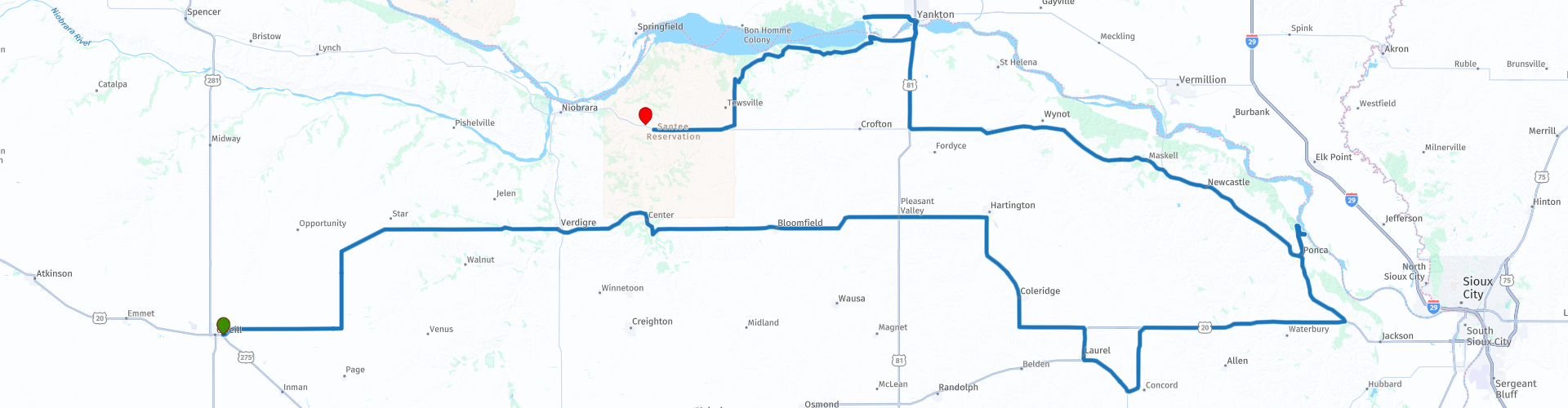
Day 95 The Ultimate USA road trip ONeill Niobrara

This route was brought to you by:
RouteXpert René Plücken (MRA Master)
Last edit: 27-11-2023
 Route Summary
 I have further supplemented the Road Trip with even more special points that you can visit in the USA. Today we drive from O'Neill to Niobrara, Nebraska. It is a long drive of almost 390 kilometers.
We drive on beautiful roads through the green agricultural area of Nebraska and we drive part of Nebraska's “Outlaw Trail Scenic Byway Highway 12”. A nice one with a number of stops at sights. I rate this route 4 stars.
 Share this route


Animation

Verdict


Duration
9h 54m

Mode of travel
Car or motorcycle

Distance
385.78 km

Countries

 RouteXpert Review
 Along the route there are several small villages and neighborhood communities where a variety of accommodations and dining options are offered for breaks, food and possibly an overnight stay.
During the year there are also events along the OTSB that are worth a visit, these range from rodeos and Pow Wows (a gathering where Native Americans dance, sing and party), to winery tours and arts and crafts shows. There are a number of museums and murals along the route. This region of Nebraska offers seasonal opportunities to hunt fauna or flora with guns or cameras.
The “Outlaw Trail Scenic Byway Highway 12” crosses three excellent state parks: “Ponca State Park,” “Niobrara State Park,” “Smith Falls” and numerous “Wildlife Management Areas” that offer camping, golfing, swimming, boating, fishing , off road rides and hiking. More information about “Outlaw Trail Scenic Byway Highway 12” can be found at the links in this review.
Enjoy the first part of this 230-mile (371-kilometer) ride through the diverse landscape of Nebraska, stretching from South Sioux City to Valentine. This byway also parallels the route of the Lewis and Clark Corps of Discovery Trail. We drive the second part on day 96 of “The Ultimate USA road trip”.
During this day we visit Ponca State Park. There are 22 miles of hiking and biking trails that wind through the park's deep ravines and ridges. The Three State Overlook offers scenic views of the cliffs of Nebraska, Iowa and South Dakota. The park offers a fishing pond, swimming pool, campsites and cabins. An interactive museum in the park's Visitor Center contains exhibits about the Missouri River and its history.
We briefly leave the trail to visit the Nissen Family Vineyards, nestled in the rolling hills of northern Cedar County, Nebraska. It is a family-run vineyard and winery located on the Outlaw Trail National Scenic Byway in Nebraska. They have been producing fine Nebraska wines on a 400 acre farm since 2003. Definitely a nice stop for wine lovers, but be careful with alcohol because safety comes first.
We also visit Yankton, South Dakota located on the banks of the Missouri River along the South Dakota-Nebraska border. Yankton is rich in natural beauty and water recreation.
Visit the Meridian District in Yankton Downtown, with its boutiques, galleries and dining options. A perfect stop to plan a late lunch. Stroll across the historic Meridian Bridge near scenic Riverside Park, which is also a perfect place to enjoy a picnic overlooking the Missouri River.
You can visit the Lewis and Clark Recreation Area, a popular resort park with sandy beaches, campsites, cabins, boat rentals, fishing areas and a horse camp. Explore the nature trails and see the aquarium at Gavins Point National Fish Hatchery.
The trip ends at the Ohiya Casino & Resort in Niobrara.


 Links
Links  Usage
Usage Want to download this route?
You can download the route for free without MyRoute-app account. To do so, open the route and click 'save as'. Want to edit this route?
No problem, start by opening the route. Follow the tutorial and create your personal MyRoute-app account. After registration, your trial starts automatically.  Disclaimer
Use of this GPS route is at your own expense and risk. The route has been carefully composed and checked by a MyRoute-app accredited RouteXpert for use on TomTom, Garmin and MyRoute-app Navigation.
Changes may nevertheless have occurred due to changed circumstances, road diversions or seasonal closures. We therefore recommend checking each route before use.
Preferably use the route track in your navigation system. More information about the use of MyRoute-app can be found on the website under 'Community' or 'Academy'.

South Dakota
About this region
South Dakota (Sioux: Dakȟóta itókaga) is a U.S. state in the upper Midwestern United States. It is named after the Lakota and Dakota Sioux Native American tribes, who comprise a large portion of the population with nine reservations currently in the state and have historically dominated the territory. South Dakota is the seventeenth largest by area, but the 5th least populous, and the 5th least densely populated of the 50 United States. As the southern part of the former Dakota Territory, South Dakota became a state on November 2, 1889, simultaneously with North Dakota. They are the 39th and 40th states admitted to the union; President Benjamin Harrison shuffled the statehood papers before signing them so that no one could tell which became a state first. Pierre is the state capital, and Sioux Falls, with a population of about 187,200, is South Dakota's largest city.
South Dakota is bordered by the states of North Dakota (to the north), Minnesota (to the east), Iowa (to the southeast), Nebraska (to the south), Wyoming (to the west), and Montana (to the northwest). The state is bisected by the Missouri River, dividing South Dakota into two geographically and socially distinct halves, known to residents as "East River" and "West River".Eastern South Dakota is home to most of the state's population, and the area's fertile soil is used to grow a variety of crops. West of the Missouri River, ranching is the predominant agricultural activity, and the economy is more dependent on tourism and defense spending. Most of the Native American reservations are in West River. The Black Hills, a group of low pine-covered mountains sacred to the Sioux, is in the southwest part of the state. Mount Rushmore, a major tourist destination, is there. South Dakota has a temperate continental climate, with four distinct seasons and precipitation ranging from moderate in the east to semi-arid in the west. The state's ecology features species typical of a North American grassland biome.
Humans have inhabited the area for several millennia, with the Sioux becoming dominant by the early 19th century. In the late 19th century, European-American settlement intensified after a gold rush in the Black Hills and the construction of railroads from the east. Encroaching miners and settlers triggered a number of Indian wars, ending with the Wounded Knee Massacre in 1890. Key events in the 20th century included the Dust Bowl and Great Depression, increased federal spending during the 1940s and 1950s for agriculture and defense, and an industrialization of agriculture that has reduced family farming.
While several Democrats have represented South Dakota for multiple terms in both chambers of Congress, the state government is largely controlled by the Republican Party, whose nominees have carried South Dakota in each of the last 13 presidential elections. Historically dominated by an agricultural economy and a rural lifestyle, South Dakota has recently sought to diversify its economy in areas to attract and retain residents. South Dakota's history and rural character still influence strongly the state's culture.
Read more on Wikipedia
South Dakota is bordered by the states of North Dakota (to the north), Minnesota (to the east), Iowa (to the southeast), Nebraska (to the south), Wyoming (to the west), and Montana (to the northwest). The state is bisected by the Missouri River, dividing South Dakota into two geographically and socially distinct halves, known to residents as "East River" and "West River".Eastern South Dakota is home to most of the state's population, and the area's fertile soil is used to grow a variety of crops. West of the Missouri River, ranching is the predominant agricultural activity, and the economy is more dependent on tourism and defense spending. Most of the Native American reservations are in West River. The Black Hills, a group of low pine-covered mountains sacred to the Sioux, is in the southwest part of the state. Mount Rushmore, a major tourist destination, is there. South Dakota has a temperate continental climate, with four distinct seasons and precipitation ranging from moderate in the east to semi-arid in the west. The state's ecology features species typical of a North American grassland biome.
Humans have inhabited the area for several millennia, with the Sioux becoming dominant by the early 19th century. In the late 19th century, European-American settlement intensified after a gold rush in the Black Hills and the construction of railroads from the east. Encroaching miners and settlers triggered a number of Indian wars, ending with the Wounded Knee Massacre in 1890. Key events in the 20th century included the Dust Bowl and Great Depression, increased federal spending during the 1940s and 1950s for agriculture and defense, and an industrialization of agriculture that has reduced family farming.
While several Democrats have represented South Dakota for multiple terms in both chambers of Congress, the state government is largely controlled by the Republican Party, whose nominees have carried South Dakota in each of the last 13 presidential elections. Historically dominated by an agricultural economy and a rural lifestyle, South Dakota has recently sought to diversify its economy in areas to attract and retain residents. South Dakota's history and rural character still influence strongly the state's culture.
View region
 Statistics
  10
10Amount of RX reviews (South Dakota)
 10960
10960Amount of visitors (South Dakota)
 135
135Amount of downloads (South Dakota)
 Route Collections in this region
 Top car and motorcycle tour through the Midwest of the USA
By car or motorcycle through the Midwest of America is a journey that you do not just make, so it is not a 13-day drive and then back home. No, book a stay of several days in Denver, Cheyenne, Rapid City (In August the Sturgis Bike Ralley, stay there for a day or 4), Yellowstone National Park, Estes Park and again Denver to also visit several places of interest in these cities, so that this tour becomes an unforgettable tour that you can remember with pleasure.
Do not forget to arrange and pack the following items:
*This is only a summary and completely personal and may differ per person.
Take out travel insurance, +31 for numbers in GSM, (partially) take out gas, Health insurance coverage at destination?, Switch off electrical appliances, Lighting (time clock), Check passport validity, Antenna from radio/TV due to lightning, Residence address for those left behind, Remote control house alarm, Book Smart Parking.
Hand luggage:
Liquids in packaging of max. 100 ml, Liquids in hand luggage in transparent plastic bag.
For on the road:
Candy, Book, Earplugs, Country and road map(s), Directions, Maps in your navigation system
Money & Securities:
Bank card / giro card, Credit card (think pin code), Cash, Calculator for Internet banking, Medical insurance card, Travel insurance card.
Travel documents:
Passport, (International) Driver's License, Ticket(s), Reservation Tickets, Hotel Vouchers, Arrival/Departure Time, Check-in & Check-out Times, Valid Visa (ESTA), Travel Guide.
Clothing:
Underwear, Belt, Shirts/ T-shirts, Shorts, Long pants, Shoes, Socks, Swim trunks, Towel, Slippers.
Personal stuff:
Watch, House Keys, Wallet, Sunglasses.
Toiletries:
Deodorant, Shower gel / Soap, Comb / brush, Shaving equipment, Shampoo, Toothbrush, Toothpaste, Sanitary pads
Health & Medicine:
Own medicines, Insect repellent, Cold sore ointment, Ointment for insect bites, Sunscreen, Norit, Paracetamol, Suction cup for insect bites, First aid bag.
Miscellaneous:
Travel bag / waist bag, Leatherman (= checked luggage), Pen or pencil, Headlamp, Lighter, Tools & Electronics, Mobile phone & charger, Photo/video camera & charger, Memory card(s), World plug / adapter, Ipod & charger, Adapter cable Ipod, Headphones, iPad & charger, Navigation & charger/plug, Plug socket, Fuelpack battery.
Engine (accessories):
Helmet, Motorcycle clothing, Motorcycle boots, Chain lock / disc brake lock, Gloves, Bandana, Inner bags (plastic shopping bag), Insulation bag, Tension straps, Tie wraps, Rain suit, Rainaway.
Addresses:
Address list, Embassy telephone number, Telephone number to block (bank) card(s), Telephone number (airline tickets).
View Route Collection
The 10 most downloaded routes in the USA from RouteXpert Hans van de Ven
Hello and welcome to this collection of the Top 10 MyRoute app downloaded routes in USA.
There will be a great new event to be announced soon, where all these routes can be driven.
Download them all now and place them in a new "Top 10" folder, so that you always have them at hand.
If you are going to drive one of these routes in the meantime, track them with the MRA Mobile App or with MRA Navigation. Take some photos (moments) along the way as these will come in handy.
Create a travelogue of your Top 10 driven routes and add the recorded track to it.
There will also be some great prizes on offer, so keep an eye on the MRA-RouteXperts page and your mail.
The 10 routes are:
1. D13 Estes Park Denver
2. D03 Chadron Custer
3. D01 Pigeon Forge round trip through the Smokey Mountains
4. D08 Kalispell Sandpoint
5. D10 Colville Wenatchee
6. D09 Sandpoint Colville
7. D04 Custer Wall
8. D11 Wenatchee Seattle
9. D08 Cody Yellowstone NP
10.R13 San Francisco Monterey
View Route Collection