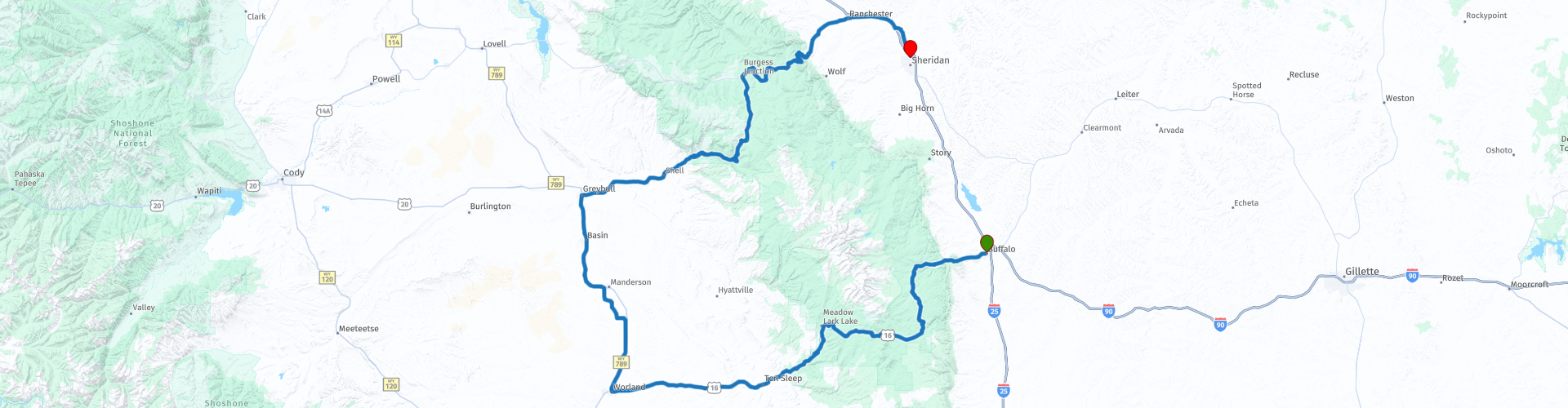
Day 100 The Ultimate USA road trip Buffalo Sheridan

This route was brought to you by:
RouteXpert René Plücken (MRA Master)
Last edit: 22-12-2023
 Route Summary
 I have further supplemented the Road Trip with even more special points that you can visit in the USA. Today we drive from Buffalo to Sheridan Wyoming. It is a beautiful ride of almost 360 kilometers.
We drive on beautiful mountain roads through the Black Hills and through the fields of Wyoming. This is a beautiful route with some beautiful sights. We drive on the Cloud Peak Skyway Scenic Byway (WY-16) and the Bighorn Scenic Byway. I rate this route 5 stars.
 Share this route


Animation

Verdict


Duration
9h 47m

Mode of travel
Car or motorcycle

Distance
358.42 km

Countries

 RouteXpert Review
 Before leaving Buffalo there is an opportunity to visit the Jim Gatchell Memorial Museum, housed in a 1909 Carnegie Library building. The museum doesn't open until 9:00 AM so we leave later than usual.
The Carnegie Public Library in Buffalo, Wyoming was built in 1909 next to the Johnson County Courthouse in the neoclassical style. In the late 1980s, the Jim Gatchell Memorial Museum acquired the library and moved the original museum to the library.
The original museum was founded in 1957 and focuses on Johnson County and border history. The museum's dioramas depict historical events and life along the Bozeman Trail, including the Wagon Box Fight, the Johnson County War between ranchers in the 1890s, the Siege of the TA Ranch and a view of Buffalo's Main Street in 1894. the artifacts include frontier and military items, weapons, wagons, Native American artifacts, drovers' equipment, and household and historical items. There is a furnished log cabin with two rooms on the property.
Leaving Buffalo on US-Route WY-16 also known as the Cloud Peak Skyway, this 64 mile (103km) drive winds through the southern portion of Buffalo's Big Horn National Forest over the Powder River Pass, passing the awe-inspiring Ten Sleep Canyon and beyond to the communities of “Ten Sleep” and Worland. The Skyway is an ideal route to Yellowstone and Grand Teton National Parks or heading east to Mount Rushmore, the Black Hills and the Badlands of South Dakota with beautiful mountain vistas, breathtaking meadows, open parks and forests.
The Skyway offers great views of the Cloud Peak Wilderness, Big Horn National Forest, the Big Horn Mountains and of Cloud Peak, the highest peak in the Big Horn Mountains.
There are several parking lots along the route that offer the opportunity to stop and enjoy the view and take beautiful photos. The drive through the “Ten Sleep Canyon” is spectacular, with limestone and dolomite cliffs, popular with climbers. There is a parking lot at the top of Powder River Pass, at an elevation of 9,666 ft., this spot offers beautiful views of the Big Horn Mountains.
In the town of “Ten Sleep” you can visit the “Ten Sleep Pioneer Museum”, it is a small local museum with the mission to share the history of Ten Sleep, Wyoming. “Ten Sleep” is also an excellent place to plan lunch. You can visit the “Ten Sleep Mercantile”, or “Ten Sleep Hardware”. It is a typical small-town store and has been the focal point of the city since its construction in 1905. “Ten Sleep Mercantile” is an example of the tall, narrow and deep commercial buildings often found in small American towns. The building is clad with wooden roof trusses. The front facade features a rod-supported shed, a covered veranda with display cases and a recessed double door.
The next stop is in Washakie where we will visit the Washakie Museum and Cultural Center, it brings the past to life using fascinating exhibits to depict the relationship between the historic people of the Big Horn Basin and their environment. The unique geography of the Big Horn Basin and its world-class archaeological sites allow the museum to provide one of the best interpretive centers for local human history, from ancient mammoth hunters to early settlers, as well as the geology, archeology and paleontology of our area .
We drive north to the town of Greybull where the Bighorn Scenic Byway starts. Enjoy the drive on this 58-mile (93 km) road over the top of the Big Horn Mountains, the Byway winding past densely forested areas, lush meadows, waterfalls and deep gorges. It extends from the Powder River Basin to the Big Horn Basin.
There are several places along the route where you can stop to take photos. A nice stop is at the “Old Shell Store Kitchen & Tap House”, a great place to stop for a drink and a small snack. They offer burgers, salads and freshly baked sweets.
The drive through the Bighorn Forest is a beautiful drive, so take your time and enjoy and stop to enjoy the beautiful nature. Visit the Big Horn National Forest Visitor's Center, which provides information about the area including interpretive exhibits. A stop you should definitely plan is at Shell Creek Canyon Lookout, where you have a great view of the canyon, the rocks and a beautiful waterfall.
After this breathtaking ride we drive via Dayton to Sheridan. In Dayton, we visit the historic Dayton Mercantile, built in 1886 and renovated between June 2013 and September 2014. They sell consumable local products such as raw honey, honey candies, sauces, meat rubs, jellies, jams, soaps and lotions. In Sheridan we spend the night in one of the hotels in the center.


 Links
Links  Usage
Usage Want to download this route?
You can download the route for free without MyRoute-app account. To do so, open the route and click 'save as'. Want to edit this route?
No problem, start by opening the route. Follow the tutorial and create your personal MyRoute-app account. After registration, your trial starts automatically.  Disclaimer
Use of this GPS route is at your own expense and risk. The route has been carefully composed and checked by a MyRoute-app accredited RouteXpert for use on TomTom, Garmin and MyRoute-app Navigation.
Changes may nevertheless have occurred due to changed circumstances, road diversions or seasonal closures. We therefore recommend checking each route before use.
Preferably use the route track in your navigation system. More information about the use of MyRoute-app can be found on the website under 'Community' or 'Academy'.

Wyoming
About this region
Wyoming is a state in the Mountain West subregion of the Western United States. The 10th largest state by area, it is also the least populous and least densely populated state in the contiguous United States. It is bordered by Montana to the north and northwest, South Dakota and Nebraska to the east, Idaho to the west, Utah to the southwest, and Colorado to the south. The state population was 576,851 at the 2020 United States census, making it the least populated U.S. state. The state capital and the most populous city is Cheyenne, which had an estimated population of 63,957 in 2018.Wyoming's western half is mostly covered by the ranges and rangelands of the Rocky Mountains, while the eastern half of the state is high-elevation prairie called the High Plains. It is drier and windier than the rest of the country, being split between semi-arid and continental climates with greater temperature extremes. Almost half of the land in Wyoming is owned by the federal government, leading the state to rank 6th by area and fifth by proportion of a state's land owned by the federal government. Federal lands include two national parks—Grand Teton and Yellowstone—two national recreation areas, two national monuments, several national forests, historic sites, fish hatcheries, and wildlife refuges.
Original inhabitants of the region include the Arapaho, Crow, Lakota, and Shoshone. Southwest Wyoming was claimed by the Spanish Empire and then as Mexican territory until it was ceded to the U.S. in 1848 at the end of the Mexican–American War. The region acquired the name "Wyoming" when a bill was introduced to Congress in 1865 to provide a temporary government for the territory of Wyoming. The name had been used earlier for the Wyoming Valley in Pennsylvania, and is derived from the Munsee word xwé:wamənk, meaning "at the big river flat".Wyoming's economy is driven by tourism and the extraction of minerals such as coal, natural gas, oil, and trona. Agricultural commodities include barley, hay, livestock, sugar beets, wheat, and wool. It was the first state to allow women the right to vote and become politicians, as well as the first state to elect a female governor. Due to this part of its history, its main nickname is "The Equality State" and its official state motto is "Equal Rights". It has been a politically conservative state since the 1950s, with the Republican presidential nominee carrying the state in every election since 1968. A notable exception is Teton County, which has achieved notability for being Wyoming's most Democratic county and the only county in the state to be won by a Democrat in every election since 2004.
Read more on Wikipedia
Original inhabitants of the region include the Arapaho, Crow, Lakota, and Shoshone. Southwest Wyoming was claimed by the Spanish Empire and then as Mexican territory until it was ceded to the U.S. in 1848 at the end of the Mexican–American War. The region acquired the name "Wyoming" when a bill was introduced to Congress in 1865 to provide a temporary government for the territory of Wyoming. The name had been used earlier for the Wyoming Valley in Pennsylvania, and is derived from the Munsee word xwé:wamənk, meaning "at the big river flat".Wyoming's economy is driven by tourism and the extraction of minerals such as coal, natural gas, oil, and trona. Agricultural commodities include barley, hay, livestock, sugar beets, wheat, and wool. It was the first state to allow women the right to vote and become politicians, as well as the first state to elect a female governor. Due to this part of its history, its main nickname is "The Equality State" and its official state motto is "Equal Rights". It has been a politically conservative state since the 1950s, with the Republican presidential nominee carrying the state in every election since 1968. A notable exception is Teton County, which has achieved notability for being Wyoming's most Democratic county and the only county in the state to be won by a Democrat in every election since 2004.
View region
 Statistics
  20
20Amount of RX reviews (Wyoming)
 15439
15439Amount of visitors (Wyoming)
 321
321Amount of downloads (Wyoming)
 Route Collections in this region
 Top car and motorcycle tour through the Midwest of the USA
By car or motorcycle through the Midwest of America is a journey that you do not just make, so it is not a 13-day drive and then back home. No, book a stay of several days in Denver, Cheyenne, Rapid City (In August the Sturgis Bike Ralley, stay there for a day or 4), Yellowstone National Park, Estes Park and again Denver to also visit several places of interest in these cities, so that this tour becomes an unforgettable tour that you can remember with pleasure.
Do not forget to arrange and pack the following items:
*This is only a summary and completely personal and may differ per person.
Take out travel insurance, +31 for numbers in GSM, (partially) take out gas, Health insurance coverage at destination?, Switch off electrical appliances, Lighting (time clock), Check passport validity, Antenna from radio/TV due to lightning, Residence address for those left behind, Remote control house alarm, Book Smart Parking.
Hand luggage:
Liquids in packaging of max. 100 ml, Liquids in hand luggage in transparent plastic bag.
For on the road:
Candy, Book, Earplugs, Country and road map(s), Directions, Maps in your navigation system
Money & Securities:
Bank card / giro card, Credit card (think pin code), Cash, Calculator for Internet banking, Medical insurance card, Travel insurance card.
Travel documents:
Passport, (International) Driver's License, Ticket(s), Reservation Tickets, Hotel Vouchers, Arrival/Departure Time, Check-in & Check-out Times, Valid Visa (ESTA), Travel Guide.
Clothing:
Underwear, Belt, Shirts/ T-shirts, Shorts, Long pants, Shoes, Socks, Swim trunks, Towel, Slippers.
Personal stuff:
Watch, House Keys, Wallet, Sunglasses.
Toiletries:
Deodorant, Shower gel / Soap, Comb / brush, Shaving equipment, Shampoo, Toothbrush, Toothpaste, Sanitary pads
Health & Medicine:
Own medicines, Insect repellent, Cold sore ointment, Ointment for insect bites, Sunscreen, Norit, Paracetamol, Suction cup for insect bites, First aid bag.
Miscellaneous:
Travel bag / waist bag, Leatherman (= checked luggage), Pen or pencil, Headlamp, Lighter, Tools & Electronics, Mobile phone & charger, Photo/video camera & charger, Memory card(s), World plug / adapter, Ipod & charger, Adapter cable Ipod, Headphones, iPad & charger, Navigation & charger/plug, Plug socket, Fuelpack battery.
Engine (accessories):
Helmet, Motorcycle clothing, Motorcycle boots, Chain lock / disc brake lock, Gloves, Bandana, Inner bags (plastic shopping bag), Insulation bag, Tension straps, Tie wraps, Rain suit, Rainaway.
Addresses:
Address list, Embassy telephone number, Telephone number to block (bank) card(s), Telephone number (airline tickets).
View Route Collection
The 10 most downloaded routes in the USA from RouteXpert Hans van de Ven
Hello and welcome to this collection of the Top 10 MyRoute app downloaded routes in USA.
There will be a great new event to be announced soon, where all these routes can be driven.
Download them all now and place them in a new "Top 10" folder, so that you always have them at hand.
If you are going to drive one of these routes in the meantime, track them with the MRA Mobile App or with MRA Navigation. Take some photos (moments) along the way as these will come in handy.
Create a travelogue of your Top 10 driven routes and add the recorded track to it.
There will also be some great prizes on offer, so keep an eye on the MRA-RouteXperts page and your mail.
The 10 routes are:
1. D13 Estes Park Denver
2. D03 Chadron Custer
3. D01 Pigeon Forge round trip through the Smokey Mountains
4. D08 Kalispell Sandpoint
5. D10 Colville Wenatchee
6. D09 Sandpoint Colville
7. D04 Custer Wall
8. D11 Wenatchee Seattle
9. D08 Cody Yellowstone NP
10.R13 San Francisco Monterey
View Route Collection