Grand Tour of Switzerland 04 Visp to Lausanne through the vineyards of the Rhone Valley

This route was brought to you by:
RouteXpert Catherine De Groote RouteXpert
Last edit: 18-02-2024
 Route Summary
 Switzerland is a wonderful country to cross by motorcycle. Not only because of the beautiful roads, but also because of the cultural and other sights - and of course the beautiful mountains! The country has enormous diversity. Mountains and water in particular determine the landscape. Lake Constance in the north is one of the most popular holiday regions in Central Europe. With Lake Geneva in the far southwest, the Swiss (along with the French) also have one of the largest lakes on the continent. Don't forget Lake Maggiore in the south, although the red flag with the white cross only flies over a small part of it. There the influence of Italy becomes clear again. It is mainly based on language. This also applies to Lake Lugano, in the far south. To discover all this, the Swiss tourist office has developed a special holiday route. This panoramic road, called Grand Tour of Switzerland, is 1643 km long. Fans of mountain passes will be happy in many places. The route takes you to the Schwägalp, the San Bernardino and the Gotthard Pass. You can follow the Grand Tour in either direction, but because most tourists do the journey clockwise, the official signposts have been adjusted accordingly.
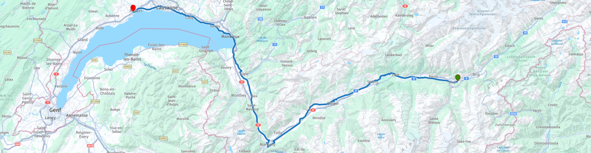
Stage 4 of the Grand Tour of Switzerland goes from Visp to Lausanne. The historic castles of Tourbillon, Valère and Chillon are on this route and are definitely worth a visit. You drive through the spectacular, often terraced vineyards of the Rhône Valley. They extend for more than a hundred kilometers at an altitude between 270 and 1100 meters.
Here too, the roads are of excellent quality. Without a doubt, this route deserves 5 stars.
 Share this route


Animation

Verdict


Duration
9h 0m

Mode of travel
Car or motorcycle

Distance
164.23 km

Countries

 RouteXpert Review
 The first vineyards start from Visp. The vineyards are not only located in the Rhône valley itself, but sometimes also in the narrow and often difficult to access side valleys. Up to Fully, on the slopes on the right side of the river, are the vineyards of Valais, facing south. Occasionally the other bank also has a number of plots, but much fewer. In June these vineyards form a large green ribbon, sometimes interrupted by industry and cities such as Sion and Sierre, villages such as Salgesch and Fully and often lonely castles on high rocks.
In Salgesch you can visit the 'Wein Museum'. The wine museum tells the history of this exceptional mountain viticulture, characterized by tradition and passion. During your visit you will learn the secrets of winemaking, but also the traditional techniques of winemakers. This exhibition, completely renovated in 2015, offers an extensive and lively panorama of the Valais wine tradition. Anyone who walks through the thirteen rooms of the museum can discover all the facets of an extraordinary wine heritage: the savoir-faire of the winemakers, the role of the terroir, the time of the grape harvest, the secrets of cellaring, the ways of drinking and enjoying, the image of wine and the art of tasting. The exhibition, playfully designed and with numerous scientific explanations, is aimed at both wine lovers and visitors who want to get to know the region better.
Château de Villa in Sierre is a 16th century castle. Now it is a famous restaurant, an oenotheque with hundreds of regional wines and various educational spaces. Part of the Valais Wine Museum is located in an outbuilding.
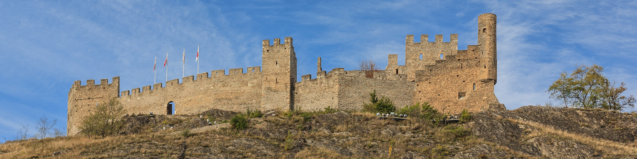
The towers of the castles of Tourbillon and Valeria in Sion can be seen from afar. Before we visit these we stop at Café Bar Le Réservoir for a coffee.
The topography of Zion is special: the city is dotted with hills. On the top of Tourbillon Hill, the highest, a castle was built around 1300 by the Bishop of Sion. On the other hill is the fortified town around the basilica of Valère.
The castle of Tourbillon owes its construction at the beginning of the 13th and 14th centuries to a bishop of Savoyard origin, Boniface de Challant, who established his residence there. In 1788 the castle was destroyed by fire together with part of the city of Sion. Within the impressive crenellated ruins still stands the well-preserved chapel of Saint-Georges and Saint-Grat, built and decorated with a first cycle of paintings at the beginning of the 14th century. In the middle of the 15th century a new cycle of paintings emerged.
The hill of Valère (protected natural area, Mediterranean flora) dominates Sion and is crowned by a fortified basilica surrounded by houses: the Château de Valère. In fact, this castle is a medieval village, supported by its church, whose bell tower is the keep. The Notre-Dame de Valère church (elevated to the rank of minor basilica by Pope John Paul II in 1987) presents itself as a harmonious example of Roman-Gothic architecture, built mainly between the 12th and 13th centuries.
Via Sion you continue west, to the central part of the largest wine-growing area in Switzerland.
Martigny, located amidst vineyards and fruit trees, is known for its gastronomy. Under the hot sun of the canton of Valais, strawberries, apricots, grapes, asparagus, etc. grow in the region. The culinary advantages of the region have already attracted personalities such as Rousseau, Goethe, Stendhal or Liszt.
Martigny looks back on a two-thousand-year-old history: Celtic tribes, the Romans and Napoleon's troops have left their mark here. Today in Martigny you can admire a restored amphitheater, but also Roman baths, temples and living quarters.
You will soon arrive at Chillon Castle. Its current form is the result of several centuries of building and renovation. The excavations carried out from the end of the 19th century show that the site has been inhabited since the Bronze Age. The rocky island on which the castle stands provided both a form of natural protection and a strategic position to control the passage from the north to the south of Europe. The castle was given the oval shape of the real island on which it was built. It is about 100 m long and 50 m wide. It also took its name from the rock; the word 'Chillon' meant 'rocky platform' in an ancient language.
Lake Geneva is a lake of superlatives: mild climate, largest inland lake and lake with the most water in Central Europe. The Celts called Lake Geneva 'Lem an' Great Water; in French it is still 'Lac Léman'. And it certainly is big. Tour boats, historic paddle boats and small ferries sail on its 582 square kilometers of water surface. Scheduled boats connect the numerous villages and towns.
Montreux is literally surrounded by vineyards. Set against the breathtaking backdrop of the snow-capped Alps all year round. Due to its exceptionally mild climate, Montreux is called the capital of the Vaud Riviera, after the canton of Vaud. In addition to vines, pine trees, cypresses and even palm trees also thrive here. The Montreux Jazz Festival takes place here every year in June, the largest and most renowned music festival of its kind on European soil.
At some point you leave the road along the lake. You now drive further through the vineyards with beautiful views. You descend back to the lake to arrive a little further in Lausanne.
Lausanne's location is very picturesque: no wonder the International Olympic Committee has been based here since 1914. The city is built on three hills, surrounded by vineyards and has Lake Geneva at its feet. On the other side rise the impressive Savoie Alps. The old city center is largely car-free. Alleys with cafes and boutiques characterize the street scene in the medieval city center.
The old town is dominated by the cathedral, which is known as the most impressive early Gothic building in Switzerland. Worth seeing are the parks that exude a southern atmosphere and beautiful, palatial hotels.
The Esplanade de Montbenon is one of the busiest green spaces in Lausanne. And that is understandable. Wide lawns, shady areas, beautiful trees and an incomparable panorama. It's hard to beat that. This is one of the most beautiful balconies overlooking the lake. There is a statue of William Tell, the mythical hero of the Helvetians, with his crossbow.
The end point of this ride is just outside Lausanne, in the quieter Morges. You can stay in the hotel La Longeraie. The La Longeraie agricultural estate, founded in 1737, became a boarding school in 1912. The building combines the charm of old stones with a green park. The property is a 10-minute walk from Lake Geneva and the city center. The hotel has a restaurant and bar with direct access to the garden and large terraces. It also has ample private parking.


 Links
Links  Usage
Usage Want to download this route?
You can download the route for free without MyRoute-app account. To do so, open the route and click 'save as'. Want to edit this route?
No problem, start by opening the route. Follow the tutorial and create your personal MyRoute-app account. After registration, your trial starts automatically.  Disclaimer
Use of this GPS route is at your own expense and risk. The route has been carefully composed and checked by a MyRoute-app accredited RouteXpert for use on TomTom, Garmin and MyRoute-app Navigation.
Changes may nevertheless have occurred due to changed circumstances, road diversions or seasonal closures. We therefore recommend checking each route before use.
Preferably use the route track in your navigation system. More information about the use of MyRoute-app can be found on the website under 'Community' or 'Academy'.
Vaud
About this region
Vaud ( VOH; French: (Canton de) Vaud, pronounced [kɑ̃tɔ̃ də vo]; German: (Kanton) Waadt, pronounced [vat] (listen) or [vaːt]), more formally the canton of Vaud, is one of the 26 cantons forming the Swiss Confederation. It is composed of ten districts and its capital city is Lausanne. Its flag bears the motto "Liberté et patrie" on a white-green background.
Vaud is the third largest canton of the country by population and fourth by size. It is located in Romandy, the French-speaking western part of the country; and borders the canton of Neuchâtel to the north, the cantons of Fribourg and Bern to the east, the canton of Valais to the south, the canton of Geneva to the south-west and France to the west. The geography of the canton includes all three natural regions of Switzerland: the Jura Mountains, the Swiss Plateau and the (Swiss) Alps. It also includes some of the largest lakes of the country: Lake Geneva and Lake Neuchâtel. It is a major tourist destination, renowned for its landscapes and gastronomy.
The largest city is Lausanne, followed by Yverdon-les-Bains and Montreux. As of 2020 the canton has a population of 814,762. It is one of the four cantons where French is the sole official language. Formerly a Bernese bailiwick, Vaud joined the Swiss Confederation as an independent canton in 1803.
Read more on Wikipedia
Vaud is the third largest canton of the country by population and fourth by size. It is located in Romandy, the French-speaking western part of the country; and borders the canton of Neuchâtel to the north, the cantons of Fribourg and Bern to the east, the canton of Valais to the south, the canton of Geneva to the south-west and France to the west. The geography of the canton includes all three natural regions of Switzerland: the Jura Mountains, the Swiss Plateau and the (Swiss) Alps. It also includes some of the largest lakes of the country: Lake Geneva and Lake Neuchâtel. It is a major tourist destination, renowned for its landscapes and gastronomy.
The largest city is Lausanne, followed by Yverdon-les-Bains and Montreux. As of 2020 the canton has a population of 814,762. It is one of the four cantons where French is the sole official language. Formerly a Bernese bailiwick, Vaud joined the Swiss Confederation as an independent canton in 1803.
View region
 Statistics
  14
14Amount of RX reviews (Vaud)
 15282
15282Amount of visitors (Vaud)
 288
288Amount of downloads (Vaud)
 Route Collections in this region
 The 24 Most Beautiful Alpine Routes
The Alps, The Alps are a mountain range in Europe, stretching from the French Mediterranean coast in the southwest to the Pannonian Plain in the east. The area of the mountain range is more than 200,000 km².
In other words Passes and Mountain Roads!
Driving through the mountains is great! Especially over the mountain passes with hairpin bends and narrow winding roads. Every bend a different view where you can enjoy. There are many beautiful mountain passes in the Alps.
A selection that has also been incorporated into these routes:
The Stlevio Pass:
The Stelvio Pass, also known as Passo dello Stelvio, is mainly known for the stage in the Giro d'Italia. Due to the length and the difference in height, this pass is seen as one of the toughest tests in cycling. The Stelvio Pass reaches a maximum height of 2758 meters and is therefore one of the highest in the Alps. The pass connects the towns of Bormio and Prato Allo Stelvio. In winter the pass is closed due to heavy snowfall.
The Reschenpass:
The Reschenpass, also known as Passo di Resia, connects the Austrian state of Tyrol with the Italian province of South Tyrol. The pass reaches a maximum height of 1,504 meters and has been one of the most important north-south connections in the Alps in recent centuries. The pass was used long before Roman times. Along the way you will pass several highlights and historical relics. One of the highlights is the Reschensee. This lake was created after the construction of the dam and has completely submerged the village of Graun. The only thing that reminds of that is the clock tower in the middle of the lake.
Col du Galibier:
The French mountain pass Col du Galibier connects the towns of Saint-Michel-de-Maurienne and Briançon via the Col du Lautaret in the south and the Col du Télégraphe in the north. The mountain pass is part of the Tour de France and very much feared, due to the fact that it can only be reached via the other two mountain passes. The pass reaches a maximum height of 2646 meters. From there you can take a walk to the viewpoint at 2704 meters. You can admire the peaks of the Grand Galibier, Mont Blanc and La Meije here.
The Grossglockner High Alpine Road:
With a height of 3798 meters the Grossglockner is the highest mountain in Austria. To fully enjoy this impressive mountain, you can drive over the Grossglockner High Alpine Road and the accompanying pass. The route starts from Bruck am Grossglockner and ends in Heiligenblut. Of course you can drive in two directions. The pass reaches a maximum height of 2504 meters and is closed in winter due to heavy snowfall. Along the way you pass several stops with fun activities, information points, mountain huts and viewpoints. A visit to the Kaiser-Franz-Josefs-Höhe and Pasterzen Glacier is highly recommended.
The Col d'Izoard:
Just like the Col du Galibier, the Col d'Izoard is also part of a stage of the Tour de France. The mountain pass connects Briançon with the valley of the river Guil. The pass is partly located in the Regional Natural Park du Queyras and reaches a maximum height of 2360 meters. What is special about the Col d'Izoard is the barren and rocky landscape. Sometimes it feels like driving a car over the moon! Along the way you can stop at several points to enjoy the beautiful view.
The Bernina Pass:
The Bernina Express is one of the most famous rail trains in Switzerland and the Alps. The route is beautiful and partly included on the UNESCO World Heritage List. Parallel to the railway lies the Bernina pass, which connects the Veltlin valley with the Egandin valley. This beautiful Alpine road has a total length of 56 kilometers and reaches a maximum height of 2328 meters. Along the way you can enjoy views of the Morteratsch Glacier.
The Sella Pass:
The Sella Pass, also known as Passo di Sella, takes you over one of the most impressive mountain ranges in the Dolomites: the Sella massif. The pass connects Valle di Fassa with Val Gardena and reaches a maximum height of 2236 meters. At this height is also the border of the Italian provinces of Trentino and Bolzano. Along the way you can enjoy the view of this spectacular mountain world. Admire, for example, the three peaks of the Sasso Lungo massif, the Sella massif or the peaks of the Marmolada. You can also drive the Sella pass in combination with the Gardena pass, Pordoi pass and Campolongo pass.
The Grimsel Pass:
The Grimsel Pass connects Goms in Wallis with the Halis Valley in the Bernese Oberland. The pass reaches a maximum elevation of 2165 meters and is closed in winter due to snowfall. Over the centuries, the mountain pass has played an important role in trade between Switzerland and Italy. Now it is mainly the reservoirs that have an important function. These are used to generate electricity. The landscape you drive through is rugged, rocky and impressive. On top of the pass is a hotel and a restaurant with a special marmot park. The Dodensee (Totensee) is also located here. This lake owes its name to the many soldiers who died in the time of Napoleon.
The Gotthard Pass:
The Gotthard Pass, also known as Passo del San Gottardo and Saint Gotthard, connects the Swiss towns of Airolo and Andermatt. The mountain pass and associated tunnel are especially known among holidaymakers driving from Switzerland to Italy. But where the majority opt for the tunnel, it is precisely the pass that really completes the holiday. The Gotthard Pass has a length of about 26 kilometers and reaches a maximum height of 2106 meters. The route is beautiful and takes you along old villages and beautiful views.
The Silvretta High Alpine Road and Silvretta Pass:
The Paznaun Valley in Tyrol and the Montafon in Vorarlberg are connected by the Silvretta High Alpine Road. The route has a length of 22.3 kilometers and leads from Galtür to Partenen in 34 hairpin bends, via the 2032 meter high Bielerhöhe. The Silvrettasee is also located at this point, where you can enjoy a lovely walk. The pass is closed in winter due to snowfall.
The Simplon Pass:
Just like the Gotthard Pass, many holidaymakers also travel over the Simplon Pass every year. This mountain pass connects the Rhone Valley in the canton of Valais with the Valle d'Ossola in Piemonte. The pass is open all year round and reaches a maximum height of 2005 meters. Along the way you pass a number of buildings, including the well-known Simplon Hospiz from 1825. The hospiz is managed by the monks of St. Bernard. From the highest point on the pass, all kinds of hiking routes are possible and you will also come across a hotel where you can spend the night.
The Gerlos Pass:
The Gerlos Pass connects the Salzach Valley in the Salzburgerland with the Zillertal Valley in Tyrol. The pass is part of the Gerlos Alpenstraße and runs right through the Hohe Tauern National Park. Along the way you can enjoy beautiful views of the surroundings. The pass has a length of 12 kilometers and reaches a maximum height of 1531 meters. A ride over the Gerlos Pass can be ideally combined with a visit to the Krimmler Wasserfälle.
The Great St. Bernard Pass:
The Great St. Bernard Pass, better known as Col du Grand Saint Bernard, connects the Italian province of Valle d'Aosta with the Swiss canton of Valais. The pass is one of the highest in Switzerland and reaches a maximum height of 2469 meters. Like a number of other mountain passes in this list, the Great St. Bernard Pass has also been used as a connecting road for centuries. The pass is named after the St. Bernard dogs that used to help stranded travelers along with the monks. The pass is closed in winter.
The Timmelsjoch High Alpine Road:
The Timmelsjoch High Alpine Road connects the towns of Sölden in the Ötztal and Meran in South Tyrol. Tolls must be paid on the Hochgurgl - Moos route. Via a mountain road with about 60 hairpin bends you drive through a beautiful mountain world. With the Timmelsjoch Experience you can learn more about the history, the road and the environment via various stations. You can also visit the Top Mountain Crosspoint museum.
Col de l'Iseran:
With a maximum pass height of 2770 meters, the Col l'Iséran is one of the highest mountain passes in the Alps. The pass connects Bourg-Saint-Maurice with Bonneval-sur-Arc. Via a road full of hairpin bends you pass, among other things, Val-d'Isère and a side valley of the Maurienne that lies entirely in the National Park de la Vanoise. You can spot animals such as marmots and chamois and there is also a restaurant with a chapel on top of the pass.
The Gavia Pass:
The Gavia Pass (Italian Passo di Gavia) is a mountain pass in the Italian Alps, in the Lombardy region.
It is one of the highest pass roads in Europe. The road leads through the unspoilt Stelvio National Park. The road was built in the First World War to supply Italian soldiers who fought in the Italian-Austrian border area. The pass height is one of the most beautiful in the Alps. Here is the large Lago Bianco with, to the north, the mountain San Matteo (3684 meters). Lago Nero is slightly lower on the south side of the pass. Here the mountain group of the Adamello determines the view. There are many well-marked walks in the area. During the winter the pass is closed due to the heavy snowfall. The pass is often closed until May and June due to the large amount of snow.
Promoter has made a selection of the 24 Most Beautiful Alpine routes that they have set out in recent years.
The routes go through:
France
Austria
Switzerland
Italy
The most beautiful roads, the most beautiful views, the most beautiful viewpoints. The highest mountains, the fastest descents, hairpin bend after hairpin bend, you name it you can't get enough of it.
If you go on holiday in this region, take advantage of it, ALL routes in this collection have been checked and made equal for TomTom, Garmin and MyRoute-app Navigation by a MyRoute-app RouteXpert.
Have fun with this collection and while driving one of these routes. Enjoy all the beauty that the Alps and the Dolomites have to offer. Click on “View route” to read the review of the chosen route.
I would like to hear your findings about the route(s).
View Route Collection
From the Eifel via the Alps to the Dordogne in 5 great days
Literally from the start of the Eifel you go to Camping Moto van Hans in 5 crazy rides. You cross 3 countries (Germany, France and Switzerland) several times and the number of motorcycle areas is phenomenal. Eifel, Moselle, Hunsrück, Pfälzerwald, Vosges, Jura, Alps and then along France's most beautiful rivers, the Drome, Tarn, Lot and Dordogne. The number of bends is indescribable. Make sure your phone / camera has enough space, because you will rarely experience so much beauty in such a short time. Note: Driving in mountainous areas requires some experience, the journey as a whole is "spicy"
Day 1 starts in the Eifel and ends in the middle of the Vosges. With MRA it is possible to find the smallest and best roads, which are ideal for this type of route. In the evening of course eating Flammkuchen! However, this route and that of day 2 have to be careful when working on the road in France. Gravel is sprinkled on the road here and that is not always convenient for motorcyclists.
Day 2 goes partly through the Vosges, then the Jura and then you drive a long way through Switzerland. Watch out for your speed here, otherwise it could be very expensive. You don't drive through the highest part of Switzerland, but there is plenty to steer and plenty to see. Your hotel is in Martigny. You can eat in the center, which you reach after 5 minutes.
Day 3 just starts in Switzerland and soon you are on the Route des Grandes Alpes. You tackle a number of very high passes here, such as the Iseran and the Galibier. The height differences are enormous here, you drive here deep valleys and high peaks. Spending the night in Serre Chevalier (where you could theoretically have skied a few months earlier) is a very special experience.
Day 4 still has some big passes in store, after that the route runs via the Drome and the Tarn. The rivers have cut very deep gorges in the relatively soft chalk, resulting in steep mountain formations. A lust for the eye! The old monastery where the hotel is located is not only a feast for the eyes, but also a rich culinary experience.
Day 5 is the last day and takes you through the Cévennes National Park. Simply put, a very large forest, but there is more. The highest peak is 1,900 meters and the roads in the Cévennes are generally very narrow. This has the advantage that they are not used much. Ergo low-traffic and excellent quality. However, on these very narrow roads you have to watch out for the local population and "waste" from the trees. The first don't take it so well with the course of the road and you regularly see it right in front of you on your side of the road, the second occasionally causes broken branches on the road. There is a good chance that at the end you will find Hans with a big grin and a welcome beer waiting for you.
All in all a very impressive ride. All 1,824.75 kilometers (according to MRA) are delightful. The roads are good, the hotels were all excellent, there were certainly culinary delights and the undersigned was very lucky that there were hardly any clouds during all 5 days (August 2023). For the less experienced rider it is advisable to gain some knowledge in advance about riding in mountains and/or to take a rest day after the "queen stage" (day 3).
For those who are going to make the journey: lots of safe kilometers and lots of fun.
View Route Collection