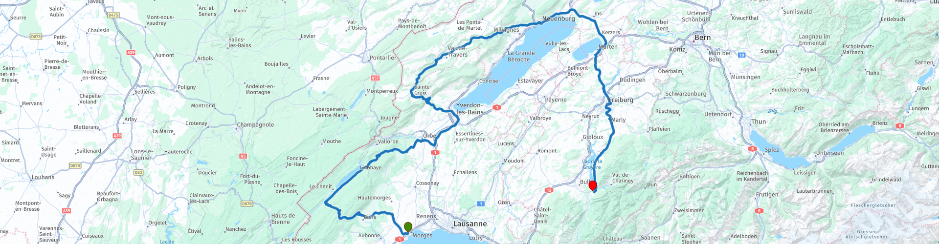
Grand Tour of Switzerland 05 Lausanne to Fribourg Broc along the Lakes Joux Neuchatel and Gruyere

This route was brought to you by:
RouteXpert Catherine De Groote RouteXpert
Last edit: 18-02-2024
 Route Summary
 Switzerland is a wonderful country to cross by motorcycle. Not only because of the beautiful roads, but also because of the cultural and other sights - and of course the beautiful mountains! The country has enormous diversity. Mountains and water in particular determine the landscape. Lake Constance in the north is one of the most popular holiday regions in Central Europe. With Lake Geneva in the far southwest, the Swiss (along with the French) also have one of the largest lakes on the continent. Don't forget Lake Maggiore in the south, although the red flag with the white cross only flies over a small part of it. There the influence of Italy becomes clear again. It is mainly based on language. This also applies to Lake Lugano, in the far south. To discover all this, the Swiss tourist office has developed a special holiday route. This panoramic road, called Grand Tour of Switzerland, is 1643 km long. Fans of mountain passes will be happy in many places. The route takes you to the Schwägalp, the San Bernardino and the Gotthard Pass. You can follow the Grand Tour in either direction, but because most tourists do the journey clockwise, the official signposts have been adjusted accordingly.
Stage 5 of the Grand Tour of Switzerland goes from Lausanne to Fribourg (Broc). You drive through an area with several large lakes such as Lake Joux, Neuchâtel and Gruyère. But here too we take the time to stop at some cultural and historical highlights such as the Abbey of Romainmôtier, the castle of Yverdon and Neuchâtel, and the cathedral of Fribourg. A ride with a varied landscape awaits you: forests, vineyards, swamps, hills,…
The roads are of excellent quality. This route therefore receives 5 stars.
 Share this route


Animation

Verdict


Duration
8h 57m

Mode of travel
Car or motorcycle

Distance
219.45 km

Countries

 RouteXpert Review
 Lonely forests, mysterious swamps, split karst rocks, open spaces and meadow landscapes lined with stone walls make this nature park particularly attractive.
The special location, the interesting geology and the extraordinary climatic conditions characterize the landscape of the Lac de Joux, the largest lake in the Jura. From the Jura Heights and the southern foot of the Jura you have an overwhelming panoramic view over Lake Geneva to the highest Alps.
You don't have to wait long for some beautiful views because the road climbs to the Col du Marchairuz. This mountain pass is located at an altitude of 1,447 meters. The road from Bière was only cleared of snow in winter in 2011, but has been open to traffic since 2012. The road is 18 kilometers long and has a gradient of 7%.
Lac de Joux is located at an altitude of 1000 m in the high valley of the same name. It is the largest lake in the Jura massif. It attracts many sailing and windsurfing enthusiasts and also allows rowing, water skiing and wakeboarding. The water temperature is between 18 and 24 degrees and therefore attracts many swimmers.
Lac de Joux and Lac des Brenets, almost contiguous but much smaller, have no surface current: the water infiltrates the earth and only reappears on the surface a few kilometers further in Vallorbe.
The Col de Pétra Félix is located at an altitude of 1,146 meters. In a wooded area and within the perimeter of the Jura Vaudois Regional Natural Park, the pass is located northeast of the Lac de Joux on the border of the municipalities of L'Abbaye (Jura-Nord Vaudois district) in the east and Mont-la-Ville ( Morges district) in the west, on the heights of the Orbe valley.
Located in a beautiful green environment, Romainmôtier lives to the rhythm of its abbey church, built on the model of the church of Cluny. Popular services and concerts are regularly held in one of Switzerland's oldest Romanesque churches.
The abbey church of Romainmôtier, built between 990 and 1028 according to the plans of the church of Cluny, is one of the gems of the Northern Vaudois region. A visit to the beautifully preserved abbey church is a cultural activity not to be missed.
The abbey church, the scene of numerous concerts, resounds to the sounds of its large contemporary organ in both summer and winter.
Yverdon Castle is a military fortress built in 1259 by order of Peter of Savoy. Located in the center of Yverdon-les-Bains, it has undergone numerous transformations over the centuries. At the beginning of the 19th century it housed the famous educationalist Johann Heinrich Pestalozzi and his Institute for Boys. With his collaborators, Pestalozzi developed an innovative method in what should be called an educational laboratory. The castle then housed public schools until 1974.
The castle, center of the rich Museum of Yverdon and the region, which it has housed since 1915 to trace the history of the city and its territory for almost 10,000 years, has been the setting of a rich history that extends far beyond its borders is known.
After Yverdon-les-Bains you drive to the Col des Etroits. The road winds through the landscape with views of the surrounding mountains to the right and left. After Vuiteboeuf we have some beautiful hairpin bends that take us to the top of the Col des Etroits.
The pass is located between Le Cochet (1,483 m) in the northeast and the Monts des Cerfs (1,256 m) in the southwest. On the northeastern slope flows the water of the Buttes, a tributary of the Areuse, which itself flows into Lake Neuchâtel. On the other side of the pass, on the southeast side, is the Arnon, which also flows into Lake Neuchâtel. This pass is therefore located in the basin of the Aare (tributary of the Rhine).
The use of the pass as an access road probably dates back to ancient times. The development of traffic dates back to the 14th and 15th centuries. It allowed the passage of Comtois salt and Burgundian wine. The road was rebuilt at various times.
You follow the Areuse valley to Lake Neuchâtel. With a length of 38 km and a width of 8 km, it is the largest lake located entirely in Switzerland. There are not only vineyards as far as the eye can see, but also a variety of small, characteristic villages along the beautiful waterfront. The city of the same name on the north bank, called Neuenburg in German, is also impressive. It is the capital of the French-speaking canton of Neuchâtel.
The most beautiful sights of this university city are the castle and the monastery church.
The castle, which used to belong to the Kingdom of Burgundy, was owned by several noble families. Even the Prussians once owned it, before it came into the possession of the canton of Neuchâtel and became the seat of government. The cantonal parliament, the Grand Council, is also located there.
The impressive castle towers partly served as dungeons, but some were also inhabited. Some of them date from before the year 1000. The richly decorated facade of the southern wing is built in Romanesque style.
In addition to the castle, the Romanesque-Gothic church of Notre-Dame with its cloister is also worth a visit. The castle and the abbey church form an architectural whole. The castle is surrounded by gardens and from the forecourt you have a wonderful view of the city and the lake.
With a loop to the south you reach Fribourg - or Freiburg. The city is located on a rocky spur and surrounded on three sides by the meanders of the Saane. The old part of the city owes its medieval charm to more than 200 unique Gothic facades from the 15th century. A 2-kilometer city wall with numerous towers and a large stronghold has been preserved and once protected the city from uninvited guests. The most spectacular building, however, is the Gothic cathedral with its beautiful stained glass windows. Construction of the cathedral started in 1283 and was completed in various phases. It is dedicated to St. Nicolas and has a 74 high tower with a breathtaking 360 degree panorama.
Fribourg is also the name of the canton that you are now crossing. In this region you can eat cheese to your heart's content. Indeed, the harmonious landscape of the Gruyère district, with Lake Gruyère, is home to the black-spotted Freiburg cows, which provide the milk for the spicy Gruyère cheese. The route then takes you through the Gruyère Pays-d'Enhaut Regional Natural Park. This region is the cradle of cheeses such as (again) Gruyère, L'Etivaz and Vacherin Fribourgeois. The merchants from this region used to be called 'cheese barons'.
The Lac de la Gruyère is sometimes called the most beautiful reservoir in Switzerland in terms of landscape. What is certain is that the storage lake between Freiburg and Bulle, crossed by the River Saane (French: Sarine), is the longest in the country at 13.5 km. The dam at Rossens was completed in 1947.
At the southern end of the reservoir is the village of Broc. Switzerland's first chocolate factory was built here in 1898, built by the chocolate pioneer Alexandre Cailler. Guided tours (including a visit to the factory shop) give you a glimpse into the sweet secrets of chocolate making.
Broc is also the end point of this route. The Hotel de Ville offers elegant rooms with free Wi-Fi. There is an on-site restaurant and café bar. All rooms feature cable TV, a private bathroom with shower and mountain views.
Traditional Swiss and Mediterranean specialties are served in the restaurant. When the weather is nice, you can enjoy the view of the Alps from the terrace.


 Links
Links  Usage
Usage Want to download this route?
You can download the route for free without MyRoute-app account. To do so, open the route and click 'save as'. Want to edit this route?
No problem, start by opening the route. Follow the tutorial and create your personal MyRoute-app account. After registration, your trial starts automatically.  Disclaimer
Use of this GPS route is at your own expense and risk. The route has been carefully composed and checked by a MyRoute-app accredited RouteXpert for use on TomTom, Garmin and MyRoute-app Navigation.
Changes may nevertheless have occurred due to changed circumstances, road diversions or seasonal closures. We therefore recommend checking each route before use.
Preferably use the route track in your navigation system. More information about the use of MyRoute-app can be found on the website under 'Community' or 'Academy'.

Fribourg
About this region
The canton of Fribourg, also canton of Freiburg (French: canton de Fribourg [kɑ̃tɔ̃ d(ə) fʁibuʁ]; German: Kanton Freiburg [ˈfraɪbʊrɡ] (listen); Arpitan: Canton de Fribôrg [cɛ̃ˈtɔ̃ də fʁiˈbwa] (listen)) is located in western Switzerland. The canton is bilingual, with French spoken by two thirds of the citizens and German by about one third. Both are official languages in the canton. The canton takes its name from its capital city of Fribourg.
Read more on Wikipedia
View region
 Statistics
  9
9Amount of RX reviews (Fribourg)
 202
202Amount of visitors (Fribourg)
 116
116Amount of downloads (Fribourg)
 Route Collections in this region
 From the Eifel via the Alps to the Dordogne in 5 great days
Literally from the start of the Eifel you go to Camping Moto van Hans in 5 crazy rides. You cross 3 countries (Germany, France and Switzerland) several times and the number of motorcycle areas is phenomenal. Eifel, Moselle, Hunsrück, Pfälzerwald, Vosges, Jura, Alps and then along France's most beautiful rivers, the Drome, Tarn, Lot and Dordogne. The number of bends is indescribable. Make sure your phone / camera has enough space, because you will rarely experience so much beauty in such a short time. Note: Driving in mountainous areas requires some experience, the journey as a whole is "spicy"
Day 1 starts in the Eifel and ends in the middle of the Vosges. With MRA it is possible to find the smallest and best roads, which are ideal for this type of route. In the evening of course eating Flammkuchen! However, this route and that of day 2 have to be careful when working on the road in France. Gravel is sprinkled on the road here and that is not always convenient for motorcyclists.
Day 2 goes partly through the Vosges, then the Jura and then you drive a long way through Switzerland. Watch out for your speed here, otherwise it could be very expensive. You don't drive through the highest part of Switzerland, but there is plenty to steer and plenty to see. Your hotel is in Martigny. You can eat in the center, which you reach after 5 minutes.
Day 3 just starts in Switzerland and soon you are on the Route des Grandes Alpes. You tackle a number of very high passes here, such as the Iseran and the Galibier. The height differences are enormous here, you drive here deep valleys and high peaks. Spending the night in Serre Chevalier (where you could theoretically have skied a few months earlier) is a very special experience.
Day 4 still has some big passes in store, after that the route runs via the Drome and the Tarn. The rivers have cut very deep gorges in the relatively soft chalk, resulting in steep mountain formations. A lust for the eye! The old monastery where the hotel is located is not only a feast for the eyes, but also a rich culinary experience.
Day 5 is the last day and takes you through the Cévennes National Park. Simply put, a very large forest, but there is more. The highest peak is 1,900 meters and the roads in the Cévennes are generally very narrow. This has the advantage that they are not used much. Ergo low-traffic and excellent quality. However, on these very narrow roads you have to watch out for the local population and "waste" from the trees. The first don't take it so well with the course of the road and you regularly see it right in front of you on your side of the road, the second occasionally causes broken branches on the road. There is a good chance that at the end you will find Hans with a big grin and a welcome beer waiting for you.
All in all a very impressive ride. All 1,824.75 kilometers (according to MRA) are delightful. The roads are good, the hotels were all excellent, there were certainly culinary delights and the undersigned was very lucky that there were hardly any clouds during all 5 days (August 2023). For the less experienced rider it is advisable to gain some knowledge in advance about riding in mountains and/or to take a rest day after the "queen stage" (day 3).
For those who are going to make the journey: lots of safe kilometers and lots of fun.
View Route Collection
Grand Tour of Switzerland
'The Grand Tour of Switzerland' leads past the most beautiful sights in the country.
Switzerland is a wonderful country to cross by motorcycle. Not only because of the beautiful roads, but also because of the cultural and other sights - and of course the beautiful mountains! The country has enormous diversity. Mountains and water in particular determine the landscape. Lake Constance in the north is one of the most popular holiday regions in Central Europe. With Lake Geneva in the far southwest, the Swiss (along with the French) also have one of the largest lakes on the continent. Don't forget Lake Maggiore in the south, although the red flag with the white cross only flies over a small part of it. There the influence of Italy becomes clear again. It is mainly based on language. This also applies to Lake Lugano, in the far south. This panoramic road, called the Grand Tour of Switzerland, is more than 1600 km long. Fans of mountain passes will be happy in many places. The route takes you to the Schwägalp, the San Bernardino and the Gotthard Pass. Divided into eight rides, it is a unique road trip.
Switzerland is a wonderful country to cross by motorcycle. Not only because of the beautiful roads, but also because of the cultural and other sights - and of course the beautiful mountains! The country has enormous diversity. Mountains and water in particular determine the landscape. Lake Constance in the north is one of the most popular holiday regions in Central Europe. With Lake Geneva in the far southwest, the Swiss (along with the French) also have one of the largest lakes on the continent. Don't forget Lake Maggiore in the south, although the red flag with the white cross only flies over a small part of it. There the influence of Italy becomes clear again. It is mainly based on language. This also applies to Lake Lugano, in the far south. This panoramic road, called the Grand Tour of Switzerland, is more than 1600 km long. Fans of mountain passes will be happy in many places. The route takes you to the Schwägalp, the San Bernardino and the Gotthard Pass. Divided into eight rides, it is a unique road trip.
View Route Collection