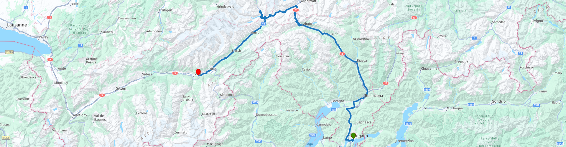
Grand Tour of Switzerland 03 Lugano to Visp over the Gothard and Furka Pass

This route was brought to you by:
RouteXpert Catherine De Groote RouteXpert
Last edit: 29-01-2024
 Route Summary
 Switzerland is a wonderful country to cross by motorcycle. Not only because of the beautiful roads, but also because of the cultural and other sights - and of course the beautiful mountains! The country has enormous diversity. Mountains and water in particular determine the landscape. Lake Constance in the north is one of the most popular holiday regions in Central Europe. With Lake Geneva in the far southwest, the Swiss (along with the French) also have one of the largest lakes on the continent. Don't forget Lake Maggiore in the south, although the red flag with the white cross only flies over a small part of it. There the influence of Italy becomes clear again. It is mainly based on language. This also applies to Lake Lugano, in the far south. To discover all this, the Swiss tourist office has developed a special holiday route. This panoramic road, called Grand Tour of Switzerland, is 1643 km long. Fans of mountain passes will be happy in many places. The route takes you to the Schwägalp, the San Bernardino and the Gotthard Pass. You can follow the Grand Tour in either direction, but because most tourists do the journey clockwise, the official signposts have been adjusted accordingly.
Stage 3 of the Grand Tour of Switzerland goes from Lugano to Visp. The road goes over the Gotthard Pass and Furkel Pass. Those who have time can also do a part of the Grimselpass. So on this ride, many hairpin bends, majestic views of the mountains and all the beautiful things nature has to offer await you. Here too, the roads are of excellent quality. Without a doubt, this route deserves 5 stars.
 Share this route


Animation

Verdict


Duration
8h 39m

Mode of travel
Car or motorcycle

Distance
228.28 km

Countries

 RouteXpert Review
 After this excursion to the Swiss version of the dolce vita, an exceptional mountain pass is on the program today, the Gotthard. You can reach it by driving back to Bellinzona and keeping to the left.
Piazza Ticino, on the mountain pass 'Passo del Monte Ceneri', with its monument made of local rocks, is the new landmark of the region. The monument has great symbolic value: the square symbolizes the union between three regions (Locarno, Bellinzona and Lugano) that used to struggle with severe mutual tensions since the formation of the canton of Ticino in 1803. The monument represents the realization of the AlpTransit project, which was completed with the Ceneri base tunnel. The monument is clad in rock quarried from the region's mountains during the construction of the AlpTransit project. The elliptical square is characterized by the presence of 5 benches and 4 new trees that create a pleasant shady resting place.
You continue to follow the Ticino valley until Airolo. Once you reach Airolo - and thus the southern slope of the Gotthard Pass - you can admire the impressive achievements that the engineers have achieved here over the past centuries. For a long time the 27 km route, completed in 1830, was the most important north-south crossing in this part of the Alps. Generations of holidaymakers drove over it on their way south. Today, through traffic flows through the Gotthard Tunnel, leaving the winding original for day trippers and motorcycle travelers. Although the route to the summit was partially rerouted on both the south and north sides between 1956 and 1977, the old pass road is still a wonderful route. But be careful: the oldest part, the Strada Vecchia, can be treacherously slippery in wet weather due to the cobblestones.
The route over the Gotthard Pass is beautiful. Along the way you enjoy views of the Swiss mountain peaks, you pass a number of cute towns and there are various viewpoints.
Just before the top you pass the mountain lake Lago della Piazza. It is located directly on the pass road at an altitude of 2089 meters. Lake Gotthard, as it is incorrectly called, is approximately 220 meters long and 180 meters wide.
Maybe this is also the time to think about your lunch. Ristorante Vecchia Sosta is definitely recommended. The restaurant will seduce you with typical local dishes or refined gastronomic dishes: pasta, risotto, meat specialties, delicious desserts and much more. The building used to be a former horse stable and has an attractive architecture and historic furnishings. The restaurant is located in the same building as the kiosk, the self-service restaurant and the Gotthard National Museum. It offers a typical alpine atmosphere, surrounded by mountains and mountain lakes.
At the top of the 2106 m high Gotthard the cobbled road ends and you get asphalt again. The road winds between the high mountains to Hospental where you turn left to the Furkapass.
The Swiss Alpine Pass has a long history since the 14th century. But the real fame for the Furka (2431 m) came in 1964 when Sean Connery as James Bond drove over the Furka in his Aston Martin DB5. No wonder scenes from the 007 Goldfinger film were filmed here, the Furka is one of the most impressive Alpine crossings in Switzerland, if not the world. Today, most of the pass is paved and only a few cobblestone stretches remind us of what it was like to cross the Alps a hundred years ago. A spectacular view awaits behind every corner. In terms of height, the Furka Pass is the fourth highest mountain pass in Switzerland. In total, the well-maintained pass roads ensure ultimate driving pleasure on two wheels. Almost the entire route offers the most beautiful mountain panoramas.
On the descent from the Furka Pass you come to the Rhône Glacier. In the 19th century and even until the early 20th century, the glacier in the source area of the Rhône reached as far as the valley floor of the Gletsch. Since the opening of the current Furka Pass crossing 150 years ago, thousands of tourists have come to see this unique mountain panorama with the Rhône Glacier. The glacier itself looks white-gray, but in the 100 m long ice tunnel and in the ice hall everything lights up in magical subtle shades of blue. The glacier here moves 30-40 meters per year, sometimes more than 10 cm in a day. A lot of ice also melts during the summer; the ice cave is still 100 meters deep at the beginning of the season, and only 70 meters at the end of the summer. One can enjoy this glacier panorama from the viewing platform and also from the platform at the glacial lake. A new glacial lake is created at the foot of the glacier.
Those who still have time or would like to drive some hairpin bends can turn right in Gletsch to the Grimselpass. The route is well maintained. The hairpin bends of the southern slope, which seem to cling spectacularly to the slope, are especially fun. The road seems to have been largely built 'on the water'. This impression is created by the numerous mountain lakes near the Grimsel. At Räterichs Bodensee you turn around to continue your original route. This extra part is approximately 12 km (round trip).
The connecting Furkastrasse runs through the Rhone Valley to Brig and Visp. The end of stage 3 of the Grand Tour of Switzerland is in sight.
In Visp you can stay in the hotel-restaurant Eyholz. The hotel has a bar, garden terrace and restaurant. There is also free parking available. This 2-star hotel has free Wi-Fi. The rooms are equipped with a flat-screen TV with satellite channels and a safe. All rooms include a coffee machine and a private bathroom with a shower and free toiletries, while some have a kitchen with a refrigerator.


 Links
Links  Usage
Usage Want to download this route?
You can download the route for free without MyRoute-app account. To do so, open the route and click 'save as'. Want to edit this route?
No problem, start by opening the route. Follow the tutorial and create your personal MyRoute-app account. After registration, your trial starts automatically.  Disclaimer
Use of this GPS route is at your own expense and risk. The route has been carefully composed and checked by a MyRoute-app accredited RouteXpert for use on TomTom, Garmin and MyRoute-app Navigation.
Changes may nevertheless have occurred due to changed circumstances, road diversions or seasonal closures. We therefore recommend checking each route before use.
Preferably use the route track in your navigation system. More information about the use of MyRoute-app can be found on the website under 'Community' or 'Academy'.

Valais
About this region
Valais (in French) (UK: VAL-ay, US: val-AY, French: [valɛ] (listen); Arpitan: Valês), or Wallis (in German) (German: Wallis [ˈvalɪs] (listen)), more formally the Canton of Valais, is one of the 26 cantons forming the Swiss Confederation. It is composed of thirteen districts and its capital and largest city is Sion. The flag of the canton is made of thirteen stars representing the districts, on a white-red background.
Valais is situated in the southwestern part of the country. It borders the cantons of Vaud and Bern to the north, the cantons of Uri and Ticino to the east, as well as Italy to the south and France to the west. It is one of the three large southern Alpine cantons, along with Ticino and the Grisons. It is a bilingual canton, French and German being its two official languages. Traditionally, the canton is divided into Lower, Central and Upper Valais, the latter region constituting the German-speaking minority.
Valais essentially coincides with the valley of the Rhône from its headwaters to Lake Geneva, separating the Pennine Alps from the Bernese Alps. A major wine region, the canton is simultaneously one of the driest regions of Switzerland in its central Rhône valley and among the wettest, having large amounts of snow and rain up on the highest peaks found in Switzerland, such as Monte Rosa and the Finsteraarhorn. Although a major hydroelectricity producer, Valais is essentially renowned for its tourism industry and for its numerous Alpine resort towns, notably Crans-Montana, Saas Fee, Verbier and Zermatt. Overlooking the latter town, the Matterhorn has become an iconic landmark of the canton.
In 1529, Valais became an associate member of the Swiss Confederation. After having resisted the Protestant Reformation and remained faithful to the Roman Catholic Church, it became a republic under the guidance of the prince-bishop of Sion in 1628. In 1815, Valais finally entered the Swiss Confederation as a canton.
Read more on Wikipedia
Valais is situated in the southwestern part of the country. It borders the cantons of Vaud and Bern to the north, the cantons of Uri and Ticino to the east, as well as Italy to the south and France to the west. It is one of the three large southern Alpine cantons, along with Ticino and the Grisons. It is a bilingual canton, French and German being its two official languages. Traditionally, the canton is divided into Lower, Central and Upper Valais, the latter region constituting the German-speaking minority.
Valais essentially coincides with the valley of the Rhône from its headwaters to Lake Geneva, separating the Pennine Alps from the Bernese Alps. A major wine region, the canton is simultaneously one of the driest regions of Switzerland in its central Rhône valley and among the wettest, having large amounts of snow and rain up on the highest peaks found in Switzerland, such as Monte Rosa and the Finsteraarhorn. Although a major hydroelectricity producer, Valais is essentially renowned for its tourism industry and for its numerous Alpine resort towns, notably Crans-Montana, Saas Fee, Verbier and Zermatt. Overlooking the latter town, the Matterhorn has become an iconic landmark of the canton.
In 1529, Valais became an associate member of the Swiss Confederation. After having resisted the Protestant Reformation and remained faithful to the Roman Catholic Church, it became a republic under the guidance of the prince-bishop of Sion in 1628. In 1815, Valais finally entered the Swiss Confederation as a canton.
View region
 Statistics
  20
20Amount of RX reviews (Valais)
 12903
12903Amount of visitors (Valais)
 1219
1219Amount of downloads (Valais)
 Route Collections in this region
 The 24 Most Beautiful Alpine Routes
The Alps, The Alps are a mountain range in Europe, stretching from the French Mediterranean coast in the southwest to the Pannonian Plain in the east. The area of the mountain range is more than 200,000 km².
In other words Passes and Mountain Roads!
Driving through the mountains is great! Especially over the mountain passes with hairpin bends and narrow winding roads. Every bend a different view where you can enjoy. There are many beautiful mountain passes in the Alps.
A selection that has also been incorporated into these routes:
The Stlevio Pass:
The Stelvio Pass, also known as Passo dello Stelvio, is mainly known for the stage in the Giro d'Italia. Due to the length and the difference in height, this pass is seen as one of the toughest tests in cycling. The Stelvio Pass reaches a maximum height of 2758 meters and is therefore one of the highest in the Alps. The pass connects the towns of Bormio and Prato Allo Stelvio. In winter the pass is closed due to heavy snowfall.
The Reschenpass:
The Reschenpass, also known as Passo di Resia, connects the Austrian state of Tyrol with the Italian province of South Tyrol. The pass reaches a maximum height of 1,504 meters and has been one of the most important north-south connections in the Alps in recent centuries. The pass was used long before Roman times. Along the way you will pass several highlights and historical relics. One of the highlights is the Reschensee. This lake was created after the construction of the dam and has completely submerged the village of Graun. The only thing that reminds of that is the clock tower in the middle of the lake.
Col du Galibier:
The French mountain pass Col du Galibier connects the towns of Saint-Michel-de-Maurienne and Briançon via the Col du Lautaret in the south and the Col du Télégraphe in the north. The mountain pass is part of the Tour de France and very much feared, due to the fact that it can only be reached via the other two mountain passes. The pass reaches a maximum height of 2646 meters. From there you can take a walk to the viewpoint at 2704 meters. You can admire the peaks of the Grand Galibier, Mont Blanc and La Meije here.
The Grossglockner High Alpine Road:
With a height of 3798 meters the Grossglockner is the highest mountain in Austria. To fully enjoy this impressive mountain, you can drive over the Grossglockner High Alpine Road and the accompanying pass. The route starts from Bruck am Grossglockner and ends in Heiligenblut. Of course you can drive in two directions. The pass reaches a maximum height of 2504 meters and is closed in winter due to heavy snowfall. Along the way you pass several stops with fun activities, information points, mountain huts and viewpoints. A visit to the Kaiser-Franz-Josefs-Höhe and Pasterzen Glacier is highly recommended.
The Col d'Izoard:
Just like the Col du Galibier, the Col d'Izoard is also part of a stage of the Tour de France. The mountain pass connects Briançon with the valley of the river Guil. The pass is partly located in the Regional Natural Park du Queyras and reaches a maximum height of 2360 meters. What is special about the Col d'Izoard is the barren and rocky landscape. Sometimes it feels like driving a car over the moon! Along the way you can stop at several points to enjoy the beautiful view.
The Bernina Pass:
The Bernina Express is one of the most famous rail trains in Switzerland and the Alps. The route is beautiful and partly included on the UNESCO World Heritage List. Parallel to the railway lies the Bernina pass, which connects the Veltlin valley with the Egandin valley. This beautiful Alpine road has a total length of 56 kilometers and reaches a maximum height of 2328 meters. Along the way you can enjoy views of the Morteratsch Glacier.
The Sella Pass:
The Sella Pass, also known as Passo di Sella, takes you over one of the most impressive mountain ranges in the Dolomites: the Sella massif. The pass connects Valle di Fassa with Val Gardena and reaches a maximum height of 2236 meters. At this height is also the border of the Italian provinces of Trentino and Bolzano. Along the way you can enjoy the view of this spectacular mountain world. Admire, for example, the three peaks of the Sasso Lungo massif, the Sella massif or the peaks of the Marmolada. You can also drive the Sella pass in combination with the Gardena pass, Pordoi pass and Campolongo pass.
The Grimsel Pass:
The Grimsel Pass connects Goms in Wallis with the Halis Valley in the Bernese Oberland. The pass reaches a maximum elevation of 2165 meters and is closed in winter due to snowfall. Over the centuries, the mountain pass has played an important role in trade between Switzerland and Italy. Now it is mainly the reservoirs that have an important function. These are used to generate electricity. The landscape you drive through is rugged, rocky and impressive. On top of the pass is a hotel and a restaurant with a special marmot park. The Dodensee (Totensee) is also located here. This lake owes its name to the many soldiers who died in the time of Napoleon.
The Gotthard Pass:
The Gotthard Pass, also known as Passo del San Gottardo and Saint Gotthard, connects the Swiss towns of Airolo and Andermatt. The mountain pass and associated tunnel are especially known among holidaymakers driving from Switzerland to Italy. But where the majority opt for the tunnel, it is precisely the pass that really completes the holiday. The Gotthard Pass has a length of about 26 kilometers and reaches a maximum height of 2106 meters. The route is beautiful and takes you along old villages and beautiful views.
The Silvretta High Alpine Road and Silvretta Pass:
The Paznaun Valley in Tyrol and the Montafon in Vorarlberg are connected by the Silvretta High Alpine Road. The route has a length of 22.3 kilometers and leads from Galtür to Partenen in 34 hairpin bends, via the 2032 meter high Bielerhöhe. The Silvrettasee is also located at this point, where you can enjoy a lovely walk. The pass is closed in winter due to snowfall.
The Simplon Pass:
Just like the Gotthard Pass, many holidaymakers also travel over the Simplon Pass every year. This mountain pass connects the Rhone Valley in the canton of Valais with the Valle d'Ossola in Piemonte. The pass is open all year round and reaches a maximum height of 2005 meters. Along the way you pass a number of buildings, including the well-known Simplon Hospiz from 1825. The hospiz is managed by the monks of St. Bernard. From the highest point on the pass, all kinds of hiking routes are possible and you will also come across a hotel where you can spend the night.
The Gerlos Pass:
The Gerlos Pass connects the Salzach Valley in the Salzburgerland with the Zillertal Valley in Tyrol. The pass is part of the Gerlos Alpenstraße and runs right through the Hohe Tauern National Park. Along the way you can enjoy beautiful views of the surroundings. The pass has a length of 12 kilometers and reaches a maximum height of 1531 meters. A ride over the Gerlos Pass can be ideally combined with a visit to the Krimmler Wasserfälle.
The Great St. Bernard Pass:
The Great St. Bernard Pass, better known as Col du Grand Saint Bernard, connects the Italian province of Valle d'Aosta with the Swiss canton of Valais. The pass is one of the highest in Switzerland and reaches a maximum height of 2469 meters. Like a number of other mountain passes in this list, the Great St. Bernard Pass has also been used as a connecting road for centuries. The pass is named after the St. Bernard dogs that used to help stranded travelers along with the monks. The pass is closed in winter.
The Timmelsjoch High Alpine Road:
The Timmelsjoch High Alpine Road connects the towns of Sölden in the Ötztal and Meran in South Tyrol. Tolls must be paid on the Hochgurgl - Moos route. Via a mountain road with about 60 hairpin bends you drive through a beautiful mountain world. With the Timmelsjoch Experience you can learn more about the history, the road and the environment via various stations. You can also visit the Top Mountain Crosspoint museum.
Col de l'Iseran:
With a maximum pass height of 2770 meters, the Col l'Iséran is one of the highest mountain passes in the Alps. The pass connects Bourg-Saint-Maurice with Bonneval-sur-Arc. Via a road full of hairpin bends you pass, among other things, Val-d'Isère and a side valley of the Maurienne that lies entirely in the National Park de la Vanoise. You can spot animals such as marmots and chamois and there is also a restaurant with a chapel on top of the pass.
The Gavia Pass:
The Gavia Pass (Italian Passo di Gavia) is a mountain pass in the Italian Alps, in the Lombardy region.
It is one of the highest pass roads in Europe. The road leads through the unspoilt Stelvio National Park. The road was built in the First World War to supply Italian soldiers who fought in the Italian-Austrian border area. The pass height is one of the most beautiful in the Alps. Here is the large Lago Bianco with, to the north, the mountain San Matteo (3684 meters). Lago Nero is slightly lower on the south side of the pass. Here the mountain group of the Adamello determines the view. There are many well-marked walks in the area. During the winter the pass is closed due to the heavy snowfall. The pass is often closed until May and June due to the large amount of snow.
Promoter has made a selection of the 24 Most Beautiful Alpine routes that they have set out in recent years.
The routes go through:
France
Austria
Switzerland
Italy
The most beautiful roads, the most beautiful views, the most beautiful viewpoints. The highest mountains, the fastest descents, hairpin bend after hairpin bend, you name it you can't get enough of it.
If you go on holiday in this region, take advantage of it, ALL routes in this collection have been checked and made equal for TomTom, Garmin and MyRoute-app Navigation by a MyRoute-app RouteXpert.
Have fun with this collection and while driving one of these routes. Enjoy all the beauty that the Alps and the Dolomites have to offer. Click on “View route” to read the review of the chosen route.
I would like to hear your findings about the route(s).
View Route Collection
Pass Parade Alps and Dolomites
The Alps, a mountain range in Europe that stretches from the French Mediterranean coast in the southwest to the Pannonian plain in the east, almost always guarantee beautiful routes. It can hardly be boring there. The many passes, vistas and variations in the landscape make the Alps a true motorcyclist's paradise. Driving around in the Alps is really quite an experience. You haven't gone through one bend yet or the next one is already on its way. Climbing from the valley, see the landscape change from wooded slopes with splashing waterfalls to alpine meadows where no trees can be found and asphalt roads that cut through the eternal snow. Arriving on top of the mountain, enjoy phenomenal views over the surrounding snow-capped peaks, as if you were on the roof of the world.
The Dolomites also form a fantastic mountain world. They are located east of the Eisacktal, through which the “Brenner Autobahn” runs, which only ends at Bolzano. The area is located in the southernmost part of the Alps, but offers a fantastic, often rugged and unreal sight due to the huge rocky peaks. Peaks that rise steeply above the green wooded slopes and Almen. Truly breathtakingly beautiful roads have been built between the peaks.
How nice would it be if these two areas were strung together by a number of routes that take in a selection of the most beautiful passes in both areas? This collection provides you with that. Starting point is the Postillion Hotel in Arnhem, where you can visit both these beautiful areas in 10 days/routes and get 35 great passes under your wheels. The 'big boys' such as the Stelvio, Timmelsjoch, Pordoi and Gardena are on the list, but also the less well-known passes in the south of the Dolomites, such as the Passo Staulanza, the Passo Rolle and the Passo Duran. In the meantime, visiting the highest asphalted point in Austria at 2829 meters is also possible. After more than 3100 kilometers you end up at the Postillion Hotel in Arnhem.
A number of sights are discussed in the review for each route. These often tell you what you see and what to do. Fun facts, quite educational. Often there are also places indicated where you can find some entertainment, for example a suspension bridge at a great height. You are completely free to visit these sights, you can of course also determine your own points of interest.
But the main thing you most likely traveled to these areas for is simply driving. And as mentioned above, you are in a true motorcycle paradise where the steering is fantastic!
Each route ends at a hotel. It is of course not an obligation to use these hotels, you can always find another place to stay in the area, that is entirely up to you. However, my experience is that they are all simple but good hotels for a very reasonable price. They are known at/can be booked via booking.com (subject to change)
The routes of these collections:
R01 Arnhem to Riol, 355km
R02 Riol to Voehrenbach, 311km
R03 Voehrenbach to Innertkirchen, 257km
R04 Innertkirchen to Susch, 303km
R05 Susch to Selva di Val Gardena, 301km
R06 Selva di Val Gardena to Castello Molina di Fiemme, 272km
R07 Castello Molina di Fiemme to Reutte, 289km
R08 Reutte to Voehrenbach, 273km
R09 Voehrenbach to Riol, 367km
R10 Riol to Arnhem, 341km
Have fun driving these routes!
View Route Collection