Day 108 The Ultimate USA road trip Fort Benton St Mary

This route was brought to you by:
RouteXpert René Plücken (MRA Master)
Last edit: 21-01-2024
 Route Summary
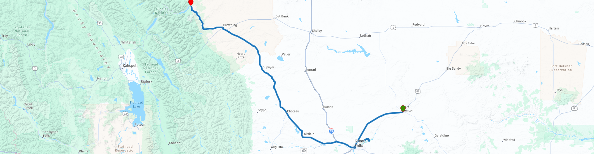
 I have further supplemented the Road Trip with even more special points that you can visit in the USA. Today we drive in Montana from Fort Benson to St Mary at the foot of Glacier National Park. It is a ride of more than 340 kilometers.
Today we drive on US Route 2, many stops are planned along the route, including museums and other historical sights. The roads take you through the vast flat part of “The Great Plains” of Montana with wide panoramas. This route is full of historical sights. I rate this route 5 stars.
 Share this route


Animation

Verdict


Duration
10h 41m

Mode of travel
Car or motorcycle

Distance
345.15 km

Countries

 RouteXpert Review
 The route runs along the Missouri River and this river contains many dams, so there are several options to visit these technically advanced structures, but for this you have to deviate from the route and sometimes drive on unpaved roads. One of the dams that is easily accessible is the Ryan Dam, a hydroelectric dam on the Missouri River, which was built in 1915 on the largest of the five Great Falls of the Missouri. The dam is divided into two parts. On the right side of the dam is the concrete arch construction. The middle part of the dam consists of an embankment that extends from the base of the falls to Ryan Island. The left side of the dam is a major powerhouse. It is a short walk from the parking lot over a bridge to Ryan Island, from where you have a nice view of the beautiful dam.
We take a break in Great Falls. This city is named after a series of five waterfalls on the Missouri River, north and east of the city. The Lewis and Clark Expedition of 1805–1806 was forced to move boats 10 miles (16 km) overland (portage) to circumvent the falls, 31 days of hard labor was expended to make the portage. Three of the waterfalls, known as Black Eagle, Rainbow and the Great Falls (or the Big Falls), are among the sites of five hydroelectric dams in the area, earning the city the nickname 'The Electric City'. Other nicknames for Great Falls include "The River City" and "Western Art Capital of the World". The city is also home to two military installations: Malmstrom Air Force Base to the east of the city, the community's largest employer, and the Montana Air National Guard to the west, adjacent to Great Falls International Airport. The federally recognized Little Shell Tribe of Chippewa Indians of Montana are located in Great Falls.
In Great Falls we take US 89, this highway is a great route to drive through Montana with beautiful views and interesting and historical sights. In Montana, US 89 connects Yellowstone National Park with Glacier National Park, so you are assured of beautiful panoramas. This part of the route is also part of the “Montana Dinosaur Trail”, so a number of stops are planned along the route at museums with exhibitions about Montana's prehistoric history. There are also a number of “Historical Markers” along the route, which are a nice stop to learn more about Montana history.
We plan a longer stop in the town of Choteau where we visit a museum and plan lunch. We visit the "Old Trail Museum", here you can learn a lot about the history of "The Rocky Mountain Front" region. There are exhibits featuring fossils and dinosaurs, as well as artifacts that tell the history of the Blackfeet and Métis Tribes. There are exhibitions about the animals that live in this area, such as grizzly bears, moose and waterfowl. There is information about the unique geology of the Rocky Mountain Front, local meteorological phenomena, as well as the varied and colorful history of Choteau, Montana, Teton County and the greater Rocky Mountain Front region.
Old Trail Museum is a nonprofit organization that reflects the rich natural and cultural history of Montana's pristine Rocky Mountain Front region. Their mission is to explore and preserve the cultural heritage of the Rocky Mountain Front region and share it with visitors. The museum is open from May 30 to September 3, Tuesday to Saturday (closed on Sundays and Mondays) from 9 a.m. to 5 p.m. (closed on July 4). Admission is $3.00 per person.
After lunch it is a 15 to 20 minute drive to the town of Byrum where we visit the Montana Dinosaur Center. This museum is a non-profit and educational institution that opened in 1995. It is part of the Montana Dinosaur Trail with exhibits of a skeletal model of a diplodocus, the first baby dinosaur bones collected in North America and specimens of new species of several types of dinosaurs including hadrosaurs, ceratopsians and tyrannosaurs. The opening hours vary per season and in the winter months by appointment only, more information can be found on the website (link in this review). Admission to the museum costs $5. During the months of June through September, excavations are also organized for visitors at one of the Montana Dinosaur Center's active fossil sites. You can book these excavations for 4 hours ($110) or 8 hours ($225).
On the way to Dupuyer we stop briefly at “The Memorial of Children Bear Doll Fence”, also known as the Teddy Bear Fence, a unique and moving attraction. It consists of a fence full of cuddly toys, including teddy bears and other cuddly toys that have been left as a tribute to deceased children. The tradition of leaving stuffed animals at this spot began in the 1990s when a local rancher found a lost teddy bear on his property and placed it on his fence. After a short break at Buffalo Joe's Eatery & Saloon in Dupuyer we drive into the Blackfeet Reservation.
At the entrance to the reserve we stop at the “Welcome to Blackfeet Nation Sculpture”, this monument is made up of pieces of rusted cars, pieces of barbed wire and the stones of an old mission school; artist Jay Laber has created a statue of two Native American warriors astride their horses at all four entrances to the Blackfeet Reservation. The horses and riders are made up of old cars that were destroyed during the flood of June 8, 1964. Both events played a major role in the history of the Blackfeet.
The Blackfeet Reservation belongs to the Blackfeet Nation, which consists of three tribes, the Pikunis or Piegans, the Bloods and the Blackfoot. Each tribe is divided into clans that mark blood relations. The majority of the Indians on this reservation are Piegans. A number of “Historical Markers” have been placed along this part of the route that tell the history of this area. These are fun stops to learn more and take photos, such as the “Old Agency” that commemorates the building of the second Indian agency on the Blackfeet Reservation in 1879, or the “Coldfeet School” about a one-room school (non-existent) built for Blackfeet children in 1933 during the New Deal.
The last stop before our final destination is a visit to the Museum of the Plains Indian in Browning. Founded in 1941, this museum features a variety of artifacts from Northern Plains tribes, including the Blackfeet, Crow, Northern Cheyenne, Sioux, Assiniboine, Arapaho, Shoshone, Nez Perce, Flathead, Chippewa and Cree. Their historic clothing, horse equipment, weapons, household items, carrying bags and toys highlight the exhibits. Promotional sales exhibitions feature contemporary Native American arts and crafts from emerging artists and artisans.
The end of the trip is in St Mary at the entrance to the National Glacier Park, we spend the night at the St Mary Lodge & Resort.


 Links
Links  Usage
Usage Want to download this route?
You can download the route for free without MyRoute-app account. To do so, open the route and click 'save as'. Want to edit this route?
No problem, start by opening the route. Follow the tutorial and create your personal MyRoute-app account. After registration, your trial starts automatically.  Disclaimer
Use of this GPS route is at your own expense and risk. The route has been carefully composed and checked by a MyRoute-app accredited RouteXpert for use on TomTom, Garmin and MyRoute-app Navigation.
Changes may nevertheless have occurred due to changed circumstances, road diversions or seasonal closures. We therefore recommend checking each route before use.
Preferably use the route track in your navigation system. More information about the use of MyRoute-app can be found on the website under 'Community' or 'Academy'.