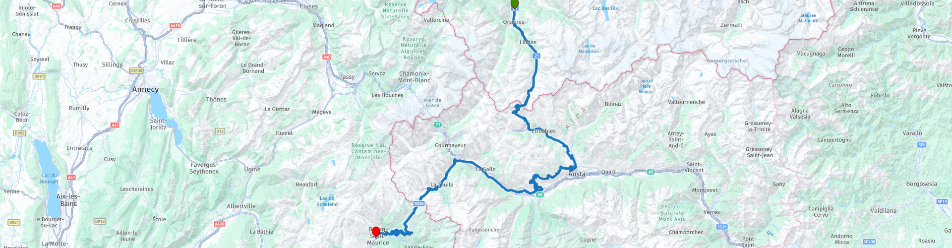
Across country borders 03 Orsieres to Bourg Saint Maurice over the Great and Little Saint Bernard Pass

This route was brought to you by:
RouteXpert Catherine De Groote RouteXpert
Last edit: 26-02-2024
 Route Summary
 The start in Lausanne on Lake Geneva alone offers beautiful views. France and three Swiss cantons share the famous water, whose coastline is one of the most beautiful in Europe.
No less impressive are the individual towns and villages you drive through. BulIe, in the heart of the Gruyère district, and Cluses, in the Arve Valley in the French Alps, are as historic as they are picturesque. This also applies to Monthey, the city on the Vièze. In between, in touristy Saanen and in Gstaad, the typical chalet architecture surprises: it belongs to Switzerland, just like skyscrapers belong to New York.
A true highlight among the Alpine passes is the Pas de Morgins, which connects Switzerland with France. The Col de la Forclaz - between the Rhone Valley and Chamonix - is also an important transport link. Chamonix is famous as the location of the first Winter Olympics in 1924. On the Swiss side you mainly see vineyards, in France dense green forests dominate the landscape. The mighty, usually snow-capped Mont-Blanc is almost always in sight. At the Col du Grand Saint-Bernard (Great St. Bernard Pass), take the road over the pass: you cannot miss the beauty of this border area between Switzerland and Italy.
During this 3rd ride you cross the borders of Switzerland, Italy and France. Hidden in the hills at the foot of Mont Blanc lies the Pays du Saint Bernard, the gateway to Italy. The Great St Bernard Pass, with its tight bends, is certainly an experience, not least because of the fantastic views. At the top is the legendary Hospice. It is also the place where the world-famous St. Bernard dogs come from. The road surface is wide and the bends are well constructed. On the way to the Little St. Bernard Pass you will have a view of the uninhabited Vallone di Chavannes. There are a number of small lakes at the pass height, and slightly lower is the larger bright blue Lago Verney. Just beyond the pass are the Hospice and the Chanousia botanical garden on French territory. Without a doubt, due to the phenomenal landscape and the good roads, this ride gets 5 stars
 Share this route


Animation

Verdict


Duration
8h 9m

Mode of travel
Car or motorcycle

Distance
167.06 km

Countries


 RouteXpert Review
 Next to a small lake and with a view of large glaciated mountains, this col is the border between the Valle d'Aosta and Wallis. Two regions full of climbs. However, anyone in one of these two regions should definitely do the climb of the Grand Saint Bernard.
The exit to the right towards the Great St. Bernard Pass is located in the tunnel; be alert to this, because you can easily miss the small sign with 'Col'. Well before the exit, a traffic sign indicates whether the pass is open or not. If you read 'aperto', the beautiful winding tour on the SS27 can begin. The spacious, asphalted road takes you between the mountains to the highest point of the pass, at 2,473 meters.
From that moment on it quickly becomes steeper. The landscape also becomes truly high mountains. In early summer you will often drive past enormous walls of snow. Beautiful winding streams through colorful Alpine meadows and steep rocks. That's kind of the idea of this climb. At least if you pay attention to it. Because it is very steep, especially in the last kilometers.
At the top of the pass, just before the border between Switzerland and Italy, is the Hospice du Grand-Saint-Bernard. This hospice was founded in 1045 by Saint Bernard to accommodate travelers crossing the Alps. It is also the place where the world-famous St. Bernard dogs come from. Augustinian monks still live here. There is also a museum about the history of the hospice and the Saint Bernard dogs. The stalls at the top of the pass sell all kinds of souvenirs that are in some way inspired by these dogs.
Immediately after the Hospice you pass the border between Switzerland and Italy unnoticed - the old customs house is no longer used. On the Italian side, a large statue of Saint Bernard looks out over the lake and the often snow-capped mountains. It is immediately a lot colder here, so high in the mountains.
From now on it will be on a downward trend. A coffee stop at Praz d'Arc is welcome. You have a beautiful view on the large terrace.
After coffee we continue on the SS27, into the special region of Valle d'Aosta.
Aosta, the city at the foot of the Colle del Gran San Bernardo, was strategically important to the Romans. Emperor Augustus therefore left around 25 BC. build the Colonia Augusta Praetoria here for 3000 soldiers - the Porta Praetoria and the ruins of the theater and amphitheater are a reminder of that time. On the square where the Roman Forum once stood, stands the cathedral Santa Maria Assunta, from the 15th and 16th centuries. The most important building in art history in Aosta is the cloister of the Santi Pietro e Orso church - considered the model for Burgundian architecture on the south side of the Alps.
However, you ignore the city of Aosta and follow the SR 38. This road is not only narrower and quieter, but especially those who like hairpin bends will enjoy it here. About 30 km further you return to the valley and the main road.
In Restaurant La Locanda dei Sognatori you can taste the most famous dishes of regional cuisine, but also dishes of Mediterranean cuisine, prepared with typical local products.
The SS26 winds into the wide valley of the small mountain village of La Thuile, at the foot of the Little Saint Bernard Pass. Here is a prehistoric stone enclosure, the origins of which date back to the Iron Age. Traces from the time of the Romans have also been found here. After all, the village was once on the road to Gaul. The parish church of La Thuile, first mentioned in 1113, is dedicated to Saint Nicholas. The accompanying bell tower dates from the 15th century. Today the place, located between high mountains and extensive glaciers, is a renowned ski resort.
After La Thuile there are many tight hairpin bends that take you to the top of the Little St. Bernard Pass. Don't forget to enjoy the beautiful views along the way!
At the top of the pass is the border between Italy and France. Just like the Great St. Bernard Pass, the Little St. Bernard Pass is also named after the adventurous nobleman Bernard van Menton, who built a hospice here for mountaineers in need.
On the Sunday after August 15, the Fête des Bergers, the Feast of the Shepherds, takes place here. It revives the time when the herdes from the Aosta Valley met with their colleagues from Savoie to trade at the cattle market. This exchange stopped during the Second World War and lives on today in the form of a folkloric fair, which valley residents, shepherds and tourists from both sides of the mountain celebrate together. A traditional highlight is the Bataille de Reines, a cow competition from which a queen emerges every year.
Shortly after the top you will arrive at the Chanousia botanical garden. In 1897, Pierre Chanoux, a priest and enthusiastic mountaineer, had a botanical garden created there. He wanted to protect the natural mountain flora and express his passion for botany. After the abbot's death, the garden fell into oblivion, but was later brought back to life. The floral splendor now attracts many visitors again. The garden is most beautiful in the warm season, between mid-May and mid-September. You can also visit the adjacent museum.
Here too, there is an impressive statue of Bernard van Menton further on.
Southwards the route continues to La Rosière and Bourg-Saint-Maurice. The road is wide and well maintained and offers pure driving pleasure, with a total of 52 hairpin bends. The winter sports resort of Les Arcs, located high above the Isère valley, helped the city to flourish economically in the 1960s.
We conclude this three-day trip at Hotel Base Camp Lodge in Bourg-Saint-Maurice.
Hotel offers accommodation with a terrace, free private parking, a restaurant and a bar. Free WiFi is available throughout the property. All rooms at the hotel have a flat-screen TV, private bathroom and bed linen. Select rooms have a kitchenette with a refrigerator and a microwave. In the BC7 restaurant, enjoy local cuisine, prepared with local products and traditional dishes, in a warm and unusual environment.


 Links
Links  Usage
Usage Want to download this route?
You can download the route for free without MyRoute-app account. To do so, open the route and click 'save as'. Want to edit this route?
No problem, start by opening the route. Follow the tutorial and create your personal MyRoute-app account. After registration, your trial starts automatically.  Disclaimer
Use of this GPS route is at your own expense and risk. The route has been carefully composed and checked by a MyRoute-app accredited RouteXpert for use on TomTom, Garmin and MyRoute-app Navigation.
Changes may nevertheless have occurred due to changed circumstances, road diversions or seasonal closures. We therefore recommend checking each route before use.
Preferably use the route track in your navigation system. More information about the use of MyRoute-app can be found on the website under 'Community' or 'Academy'.

Auvergne Rhone Alpes
About this region
Auvergne-Rhône-Alpes (ARA; French: [ovɛʁɲ ʁon‿alp] (listen); Arpitan: Ôvèrgne-Rôno-Ârpes; Occitan: Auvèrnhe Ròse Aups; Italian: Alvernia-Rodano-Alpi) is a region in southeast-central France created by the 2014 territorial reform of French regions; it resulted from the merger of Auvergne and Rhône-Alpes. The new region came into effect on 1 January 2016, after the regional elections in December 2015.The region covers an area of 69,711 km2 (26,916 sq mi), making it the third largest in metropolitan France; it had a population of 7,948,287 in 2017, second to Île-de-France. It consists of twelve departments and one territorial collectivity (Lyon Metropolis) with Lyon as the prefecture.
This new region combines diverse geographical, sociological, economic and cultural regions, which was already true of Rhône-Alpes, as well as Auvergne, to a lesser extent. While the old Rhône-Alpes and Auvergne regions each enjoyed a unity defined by axes of communication and the pull of their respective metropoles, the new combination is heterogeneous; it sustained lively opposition from some local officials after its creation.
Read more on Wikipedia
This new region combines diverse geographical, sociological, economic and cultural regions, which was already true of Rhône-Alpes, as well as Auvergne, to a lesser extent. While the old Rhône-Alpes and Auvergne regions each enjoyed a unity defined by axes of communication and the pull of their respective metropoles, the new combination is heterogeneous; it sustained lively opposition from some local officials after its creation.
View region
 Statistics
  119
119Amount of RX reviews (Auvergne Rhone Alpes)
 45152
45152Amount of visitors (Auvergne Rhone Alpes)
 5433
5433Amount of downloads (Auvergne Rhone Alpes)
 Route Collections in this region
 The 24 Most Beautiful Alpine Routes
The Alps, The Alps are a mountain range in Europe, stretching from the French Mediterranean coast in the southwest to the Pannonian Plain in the east. The area of the mountain range is more than 200,000 km².
In other words Passes and Mountain Roads!
Driving through the mountains is great! Especially over the mountain passes with hairpin bends and narrow winding roads. Every bend a different view where you can enjoy. There are many beautiful mountain passes in the Alps.
A selection that has also been incorporated into these routes:
The Stlevio Pass:
The Stelvio Pass, also known as Passo dello Stelvio, is mainly known for the stage in the Giro d'Italia. Due to the length and the difference in height, this pass is seen as one of the toughest tests in cycling. The Stelvio Pass reaches a maximum height of 2758 meters and is therefore one of the highest in the Alps. The pass connects the towns of Bormio and Prato Allo Stelvio. In winter the pass is closed due to heavy snowfall.
The Reschenpass:
The Reschenpass, also known as Passo di Resia, connects the Austrian state of Tyrol with the Italian province of South Tyrol. The pass reaches a maximum height of 1,504 meters and has been one of the most important north-south connections in the Alps in recent centuries. The pass was used long before Roman times. Along the way you will pass several highlights and historical relics. One of the highlights is the Reschensee. This lake was created after the construction of the dam and has completely submerged the village of Graun. The only thing that reminds of that is the clock tower in the middle of the lake.
Col du Galibier:
The French mountain pass Col du Galibier connects the towns of Saint-Michel-de-Maurienne and Briançon via the Col du Lautaret in the south and the Col du Télégraphe in the north. The mountain pass is part of the Tour de France and very much feared, due to the fact that it can only be reached via the other two mountain passes. The pass reaches a maximum height of 2646 meters. From there you can take a walk to the viewpoint at 2704 meters. You can admire the peaks of the Grand Galibier, Mont Blanc and La Meije here.
The Grossglockner High Alpine Road:
With a height of 3798 meters the Grossglockner is the highest mountain in Austria. To fully enjoy this impressive mountain, you can drive over the Grossglockner High Alpine Road and the accompanying pass. The route starts from Bruck am Grossglockner and ends in Heiligenblut. Of course you can drive in two directions. The pass reaches a maximum height of 2504 meters and is closed in winter due to heavy snowfall. Along the way you pass several stops with fun activities, information points, mountain huts and viewpoints. A visit to the Kaiser-Franz-Josefs-Höhe and Pasterzen Glacier is highly recommended.
The Col d'Izoard:
Just like the Col du Galibier, the Col d'Izoard is also part of a stage of the Tour de France. The mountain pass connects Briançon with the valley of the river Guil. The pass is partly located in the Regional Natural Park du Queyras and reaches a maximum height of 2360 meters. What is special about the Col d'Izoard is the barren and rocky landscape. Sometimes it feels like driving a car over the moon! Along the way you can stop at several points to enjoy the beautiful view.
The Bernina Pass:
The Bernina Express is one of the most famous rail trains in Switzerland and the Alps. The route is beautiful and partly included on the UNESCO World Heritage List. Parallel to the railway lies the Bernina pass, which connects the Veltlin valley with the Egandin valley. This beautiful Alpine road has a total length of 56 kilometers and reaches a maximum height of 2328 meters. Along the way you can enjoy views of the Morteratsch Glacier.
The Sella Pass:
The Sella Pass, also known as Passo di Sella, takes you over one of the most impressive mountain ranges in the Dolomites: the Sella massif. The pass connects Valle di Fassa with Val Gardena and reaches a maximum height of 2236 meters. At this height is also the border of the Italian provinces of Trentino and Bolzano. Along the way you can enjoy the view of this spectacular mountain world. Admire, for example, the three peaks of the Sasso Lungo massif, the Sella massif or the peaks of the Marmolada. You can also drive the Sella pass in combination with the Gardena pass, Pordoi pass and Campolongo pass.
The Grimsel Pass:
The Grimsel Pass connects Goms in Wallis with the Halis Valley in the Bernese Oberland. The pass reaches a maximum elevation of 2165 meters and is closed in winter due to snowfall. Over the centuries, the mountain pass has played an important role in trade between Switzerland and Italy. Now it is mainly the reservoirs that have an important function. These are used to generate electricity. The landscape you drive through is rugged, rocky and impressive. On top of the pass is a hotel and a restaurant with a special marmot park. The Dodensee (Totensee) is also located here. This lake owes its name to the many soldiers who died in the time of Napoleon.
The Gotthard Pass:
The Gotthard Pass, also known as Passo del San Gottardo and Saint Gotthard, connects the Swiss towns of Airolo and Andermatt. The mountain pass and associated tunnel are especially known among holidaymakers driving from Switzerland to Italy. But where the majority opt for the tunnel, it is precisely the pass that really completes the holiday. The Gotthard Pass has a length of about 26 kilometers and reaches a maximum height of 2106 meters. The route is beautiful and takes you along old villages and beautiful views.
The Silvretta High Alpine Road and Silvretta Pass:
The Paznaun Valley in Tyrol and the Montafon in Vorarlberg are connected by the Silvretta High Alpine Road. The route has a length of 22.3 kilometers and leads from Galtür to Partenen in 34 hairpin bends, via the 2032 meter high Bielerhöhe. The Silvrettasee is also located at this point, where you can enjoy a lovely walk. The pass is closed in winter due to snowfall.
The Simplon Pass:
Just like the Gotthard Pass, many holidaymakers also travel over the Simplon Pass every year. This mountain pass connects the Rhone Valley in the canton of Valais with the Valle d'Ossola in Piemonte. The pass is open all year round and reaches a maximum height of 2005 meters. Along the way you pass a number of buildings, including the well-known Simplon Hospiz from 1825. The hospiz is managed by the monks of St. Bernard. From the highest point on the pass, all kinds of hiking routes are possible and you will also come across a hotel where you can spend the night.
The Gerlos Pass:
The Gerlos Pass connects the Salzach Valley in the Salzburgerland with the Zillertal Valley in Tyrol. The pass is part of the Gerlos Alpenstraße and runs right through the Hohe Tauern National Park. Along the way you can enjoy beautiful views of the surroundings. The pass has a length of 12 kilometers and reaches a maximum height of 1531 meters. A ride over the Gerlos Pass can be ideally combined with a visit to the Krimmler Wasserfälle.
The Great St. Bernard Pass:
The Great St. Bernard Pass, better known as Col du Grand Saint Bernard, connects the Italian province of Valle d'Aosta with the Swiss canton of Valais. The pass is one of the highest in Switzerland and reaches a maximum height of 2469 meters. Like a number of other mountain passes in this list, the Great St. Bernard Pass has also been used as a connecting road for centuries. The pass is named after the St. Bernard dogs that used to help stranded travelers along with the monks. The pass is closed in winter.
The Timmelsjoch High Alpine Road:
The Timmelsjoch High Alpine Road connects the towns of Sölden in the Ötztal and Meran in South Tyrol. Tolls must be paid on the Hochgurgl - Moos route. Via a mountain road with about 60 hairpin bends you drive through a beautiful mountain world. With the Timmelsjoch Experience you can learn more about the history, the road and the environment via various stations. You can also visit the Top Mountain Crosspoint museum.
Col de l'Iseran:
With a maximum pass height of 2770 meters, the Col l'Iséran is one of the highest mountain passes in the Alps. The pass connects Bourg-Saint-Maurice with Bonneval-sur-Arc. Via a road full of hairpin bends you pass, among other things, Val-d'Isère and a side valley of the Maurienne that lies entirely in the National Park de la Vanoise. You can spot animals such as marmots and chamois and there is also a restaurant with a chapel on top of the pass.
The Gavia Pass:
The Gavia Pass (Italian Passo di Gavia) is a mountain pass in the Italian Alps, in the Lombardy region.
It is one of the highest pass roads in Europe. The road leads through the unspoilt Stelvio National Park. The road was built in the First World War to supply Italian soldiers who fought in the Italian-Austrian border area. The pass height is one of the most beautiful in the Alps. Here is the large Lago Bianco with, to the north, the mountain San Matteo (3684 meters). Lago Nero is slightly lower on the south side of the pass. Here the mountain group of the Adamello determines the view. There are many well-marked walks in the area. During the winter the pass is closed due to the heavy snowfall. The pass is often closed until May and June due to the large amount of snow.
Promoter has made a selection of the 24 Most Beautiful Alpine routes that they have set out in recent years.
The routes go through:
France
Austria
Switzerland
Italy
The most beautiful roads, the most beautiful views, the most beautiful viewpoints. The highest mountains, the fastest descents, hairpin bend after hairpin bend, you name it you can't get enough of it.
If you go on holiday in this region, take advantage of it, ALL routes in this collection have been checked and made equal for TomTom, Garmin and MyRoute-app Navigation by a MyRoute-app RouteXpert.
Have fun with this collection and while driving one of these routes. Enjoy all the beauty that the Alps and the Dolomites have to offer. Click on “View route” to read the review of the chosen route.
I would like to hear your findings about the route(s).
View Route Collection
25 Magnificent trails in France
This MRA route collection contains 25 beautiful motorcycle routes in different parts of France, such as the Ardennes, the Alsace, Vercors, the Drôme, the Ardèche, Cote d'Azure, Gorges du Verdon, the Ariège, the Dordogne and Brittany.
The routes have been carefully created by Bert Loorbach, who is an enthusiastic motorcyclist himself. He lived in France for a year and a half, during which time he devoted himself to mapping the unknown and beautiful back roads of France especially for motorcyclists.
The routes are bundled in the Motortourgids France part 1 of Kosmos publishing house and now also available in MyRouteApp.
I have taken over the routes in MRA and sometimes adjusted them slightly to make them even more interesting for the motorcyclist.
View Route Collection