Route 66 Portugal 01 Chaves Penacova

This route was brought to you by:
RouteXpert Hans van de Ven (Mr.MRA)
Last edit: 07-12-2024
 Route Summary
 You will visit a total of 33 municipalities, all with a different landscape and their own unique sights. So you can count on a mix between rugged nature and culture.
This 1st of 3 routes makes it possible to drive route 66 at your leisure. If you want to see more, you will have to allow a few more days. The N2 is the common thread in these route(s), sometimes with a small side trip because you do not want or cannot miss some sights. These special places therefore require a small detour. Use the places with an official stamp post to have something to eat and/or drink and to make contact with the locals.
Anyone traveling Portugal's Route 66 on the N2 can pick up a special yellow N2 passport from the tourist office in Chaves. Along the way you can have this passport stamped in places along the route. And what is also useful, the passport contains all kinds of nice tips for the journey. You can also download the EN2 app and digitally stamp the municipalities you pass by, and find even more useful information about this route. The app is based on reading the QR code and you just have to direct the app's QR reader to the QR code in each municipality to mark his or her passage.
The ideal period to drive route 66 is, as you drive through the interior of Portugal where the mercury quickly rises to 40 degrees in the summer months, spring and autumn. An additional advantage is that the colors in nature are at their best!
This route includes Points of Interest from the official stamp posts, Camper sites, charging points and overnight accommodations close to the route.
This beautiful route deserves 5 stars.
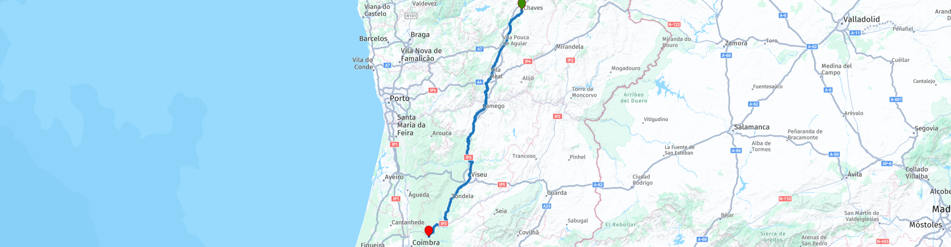
Start: Chaves
End: Penacova
Faça uma boa viagem e aproveite!
 Share this route


Animation

Verdict


Duration
5h 0m

Mode of travel
Car or motorcycle

Distance
235.21 km

Countries

 RouteXpert Review
 In Chaves, if you go to the local tourist office, where this route starts, you can apply for your passport and when you stop to visit the different places you can have it stamped. Don't forget to do that! This is great proof that you have driven Portugal's Route 66.
If you spend the night in Chaves, it is also nice to take a walk through the city. The town of Chaves, which means 'keys', is known for its Roman bridge over the Tâmega river, the smoked ham 'Presunto de Chaves' and its natural hot springs. In the caldas water bubbles up at 73°C. The water is said to have a healing effect. Those who want to be pampered in luxury can undergo a treatment with healthy spring water at Termas de Chaves. Next to the beautiful Ponte de Trajano bridge, the central square, Praça de Camões, is where the sights of Chaves can be found. Terraces, the town hall and two churches, so plenty to include in your city walk and grab a terrace for a break. An old square tower, left over from the 10th century castle, is also set in a beautiful garden behind the town square. Climb up to enjoy the view over the mountains of Trás-os-Montes.
Once on the route you will regularly encounter the N2 signs along the way, you do not have to pay special attention to them, because this route follows the N2. Arrived in Vila Real, a small town known for its country houses and churches. The Casa de Mateus country house became world famous because of the image on the labels of Mateus rosé, that of the flat round bottles.
Further south you will enter the beautiful vineyards of the Douro Valley. The village of Peso da Régua is located on the river of the same name and is the center of port production in the beautiful area. Grape plants grow in abundance on the many terraced hills. In addition to tasting the port, in Peso da Régua you can take a boat trip on the Douro to Pinhão or board a historic steam train.
In Lamego, the cultural capital of the region, the hillside sanctuary, Santuário de Nossa Senhora dos Remédios, is the highlight. But the cathedral is also a nice stop. And many churches in Lamego are covered with the widely appreciated Portuguese tiles.
The next charming city you will visit is the well-preserved historic center of Viseu. In the city, stroll through the winding streets until you reach Sé Catedral de Viseu, in the central square of Adro da Sé. This city has the highest quality of life in Portugal. Good to stop in Viseu. You can get your N2 passport stamped at Avenida Boutique Hotel, Hotel Grao Vasco and Pousada de Viseu.
Do you want to be surprised by the spectacular nature of the Serra da Estrela? Then you will have to deviate from the route or book an extra night in Viseu. The Serra da Estrela is the largest mountain range, and also a natural park. It is the westernmost part of the Castilian Parting Mountains. The highest peak, Mount Torre, measures 1993 m, making it the highest mountain on the Portuguese mainland. The Torre is not a striking mountain peak, but the flattened highest point of a mountain ridge. Exactly at the highest point of the Torre there is a geodetic signal. The Torre is, unusually for a mountain peak, easily accessible via a paved road. This highest mountain range in Portugal is located west of Viseu. Nature lovers don't know what they see; boulders in all shapes, ravines, winding roads and impressive forests. The time and distance to drive to the highest point and back to Viseu is 145 Km and almost 3 hours, so an extra overnight stay should be considered.
Would you rather continue driving from Viseu on the N2? Then you come to the village of Penacova, also the end point of this route. The Penedo do Castro viewpoint provides a picturesque view of the Mondego Valley through which the country's largest river flows. Still up for an adventure? then get into a kayak or canoe in Penacova to explore the photogenic surroundings from the Mondego River.


 Links
Links  Usage
Usage Want to download this route?
You can download the route for free without MyRoute-app account. To do so, open the route and click 'save as'. Want to edit this route?
No problem, start by opening the route. Follow the tutorial and create your personal MyRoute-app account. After registration, your trial starts automatically.  Disclaimer
Use of this GPS route is at your own expense and risk. The route has been carefully composed and checked by a MyRoute-app accredited RouteXpert for use on TomTom, Garmin and MyRoute-app Navigation.
Changes may nevertheless have occurred due to changed circumstances, road diversions or seasonal closures. We therefore recommend checking each route before use.
Preferably use the route track in your navigation system. More information about the use of MyRoute-app can be found on the website under 'Community' or 'Academy'.

Vila Real
About this region
Vila Real (Portuguese pronunciation: [ˈvilɐ ʁiˈal] (listen)) is the capital and largest city of the Vila Real District, northern Portugal. The population in 2011 was 51,850, in an area of 378.80 square kilometres (146.26 sq mi).Vila Real was ranked seventh in the list of Portugal's most livable cities in the survey of living conditions published by the Portuguese newspaper Expresso in 2007.
Read more on Wikipedia
View region
 Statistics
  5
5Amount of RX reviews (Vila Real)
 18545
18545Amount of visitors (Vila Real)
 413
413Amount of downloads (Vila Real)
 Route Collections in this region
 Ten Day Roadtrip from Spain to Portugal
This route collection describes a 10-day Road trip in the north of Spain and Portugal, a true paradise for motorcycling.
You drive over beautiful mountain ridges and through beautiful valleys. Along the way you drive through beautiful villages and countless nature reserves, great passes with countless curves, tunnels cut out of the mountains and azure blue reservoirs. The roads are fair to good, sometimes unpaved.
What you get to see along the way;
Spanish Pyrenees
Parc Naturel del Cadi-Moixero
Serra del Cadí
Serra de Moixeró
Pedraforca
Serra del Monsec
Collada de Clarà
Parque Nacional de Ordesa y Monte Perdido
Collados del Asón Natural Park.
Parque natural Saja-Besaya
Parque natural de Fuentes Carrionas y Fuente Cobre
Parque natural de la Montana de Riano y Mampodre
Picos de Europa
El Parque regional Montaña de Riaño y Mampodre
El Parque natural de Redes
The Sierra de la Culebra
Parque natural Montesinho
Along the routes there are more than enough nice places to stop for a short or longer period, these are described in the review and with a waypoint and POI included in the routes.
Have fun reading and planning your next motorcycle vacation.
If you have ridden these routes I would like to hear your feedback.
View Route Collection