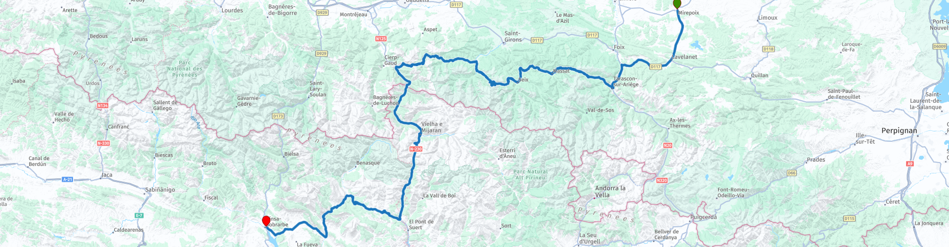
Mirepoix to Ainsa

This route was brought to you by:
RouteXpert Steve Montreal
Last edit: 02-07-2024
 Route Summary
 It is a worthy bearer of my 5* rating.
 Share this route


Animation

Verdict


Duration
9h 27m

Mode of travel
Car or motorcycle

Distance
320.54 km

Countries


 RouteXpert Review
 Before setting off on your journey, take some time to explore this lovely little town.
Originally on the right bank of the Hers River, Mirepoix was destroyed by a violent flood in 1289.
It was rebuilt in 1290, on an elevated natural terrace on the other side of the river.
The layout of the town centre has not changed since the 13th century.
At the heart of Mirepoix is Les Couverts, one of the finest surviving arcaded market squares in France. The square is bordered by houses dating from the thirteenth to the fifteenth centuries.
Many of the buildings have their rafter-ends carved with of images of animals and monsters, and caricatures of mediaeval professions and social groups.
The Cathédrale Saint-Maurice de Mirepoix, next to the square, has the second widest Gothic arch in Europe (after Girona in Catalonia, Spain).
Leaving Mirepoix the route takes us south.
Just before Aigues-Vives, look for the international karting circuit on the right. The circuit was remodelled in 2001 to reach a length of 1,402 meters & is nationally and internationally approved.
After Lavelanet we head west to Saint Antoine and the Ariege valley.
A minor road beside the river leads to Pont du Diable, or Devils Bridge.
Built in 1896, and like many bridges with the same name, there is a legend or two!.
To facilitate trade, a merchant made a deal with the Devil. In exchange for a bridge, the Devil would take the soul of the first person to cross it.
But once the bridge was built, of course no one wanted to cross it. Someone had the idea of bringing a cat across.
The deceived Devil became angry and fell into the river.
Leaving the Devil behind, as you continue south beside the river to Tarascon-sur Ariege, the Tour du Castella comes into view on its high perch overlooking the town.
The present tower was built on the site of the former medieval keep, which was rectangular in shape. It was erected in the 18th century following the demolition of the Porte de Foix, from which much of the material, including the bell and clock, was reused for construction.
The Tour du Castella is now the town's landmark, offering the best view of the surrounding area.
After Tarascon, the routes picks up some of the many routes used on the Tour de France, and the ride becomes more challenging.
The Col de Port, at 1250m, links the Couserans and Ariège valleys.
There are some lovely views across the valley from the top & a useful Tourist Information Office during the high season.
The pass is used occasionally in the Tour de France & was last used on the 2021 Tour.
Col de la Core - 1395m. During the Second World War, the Franco-Spanish border became an escape route for many people fleeing the Nazi regime, or wanting to continue the fight within free France.
The path that took the Col de la Core was known as The Chemin de la Liberté (Freedom Path). A monument pays tribute to the many that crossed.
The hillsides are used as summer pastures for cattle and horses to graze in the historic Bethmale cheese area.
The Tour de France has used the Col eight times since 1984. Last used on the 2021 Tour.
Col de Portet Aspet - The pass, rising to 1069m, located in Haute Garonne, is the high crossing point of the GR78 long distance path, called the Chemin du Piedmont Pyrénées, which is a secondary route for the pilgrimage to Santiago de Compostela.
Tragedy occurred here during the 1995 Tour de France when one of the greatest hopes of Italian cycling of that era, Fabio Casartelli, died in a fall.
Casartelli, who won the Olympic Games in 1992 at the age of 22 and was teammate to Lance Armstrong, was destined for a great career in cycling.
During this 15th stage, linking Saint Girons to Cauterets, in the descent from the Col du Portet d'Aspet several riders fall and some fall directly into the ravine.
Fabio Casartelli slipped and hit the parapet bordering the road.
At that time, wearing a helmet was not yet compulsory in racing...
Since October 1995, a stele in his memory has been erected at the scene of the tragedy and the Tour de France has become accustomed to stopping and respecting a minute of silence each time it passes this stele. It represents an angel's wing, a bicycle wheel and 5 Olympic rings.
Both the Col de Portet-d’Aspet & the following Col de Mente are included in Stage 15 of the 2024 Tour de France.
Soon you will start to scale the multiple hairpin bends to the 1369m crest of the the Col de Mente.
The Col de Menté has been used many times on the tour since its first inclusion in 1966.
At the top you will find stone memorial to Guy Lapébie.
Lapébie was a French cyclist, who won two gold and one silver medals at the 1936 Summer Olympics. After World War II he became a professional road racer.
Lapébie's elder brother was Tour de France winner Roger Lapébie. Guy's son Serge was also a professional cyclist.
On one of the hairpins of the descent you can find a plaque to TdF cyclist Luis Ocaña.
On stage 14 of the 1971 Tour de France Spanish cyclist Ocaña was in the Yellow Jersey of the Tour de France leader with an overall lead of 7 minutes on Eddy Merckx and they crossed the summit of the Col de Menté together in a storm, with streams of mud running across the road.
Merckx, an excellent descender, attacked as he descended dangerously down the mountain road.
To stay in contact with Merckx, Ocaña took many risks on the descent.
Flying through the corners, Merckx lost control and skidded into a low retaining wall at the side of the road.
Ocaña, trailing close behind, could not avoid the fallen Merckx and fell himself.
Merckx was up quickly and sped away, whilst Ocaña struggled to release his cleats from the toe clips and was struck by the pursuing Joop Zoetemelk.
Ocaña lay on the ground screaming with pain. Help arrived quickly and Ocaña was rushed by helicopter to the hospital in St. Gaudens. He recovered from his injuries, but his 1971 Tour dreams had come to an end.
The following day Merckx refused to wear the yellow jersey in order to pay tribute to Ocaña.
The memorial plaque sits at the scene of the accident on the western side of the Col de Menté.
Continuing the descent into the Garonne valley at Saint-Beat takes you south east to the French Spanish border, before entering the Vielha Tunnel.
The need for a tunnel here was identified in the 19th century, as access paths over the 2450m summit were impassable in winter. The path to Vielha was for pedestrians and horses or mules, but no vehicles could use it.
in 1830 two French engineers were commissioned to study the project, which would not be carried out for technical and economic reasons.
In 1924, following the visit of King Alfonso XIII, a new project was launched, unfortunately, the political instability of the time, then the Civil War, delayed its construction until 1948
The drilling work, with multiple interruptions, lasted 22 years. The tunnel is named after Alfonso XIII.
It was then the first road tunnel in Europe and it held the record for the longest road tunnel in the world until 1964.
After many years of use, the Alphonse XIII tunnel had become one of the most dangerous in the Pyrenees.
Peak traffic there was more than 6,000 vehicles per day, including more than 700 trucks, many transporting hazardous materials. There were no parking areas, the emergency telephones were not isolated from noise, there was no signage inside the tunnel, the evacuation galleries were neither signposted nor lit, finally there was no emergency management
In the 1980s, the Vielha tunnel did not meet any of the safety directives and the need for a new tunnel became more and more pressing.
In 1989, a study was launched to double the tunnel.
After the Mont-Blanc tunnel accident in 1999, the final project was completed and work began in 2002. After two years of delay, the new tunnel, named after King Juan Carlos I, was inaugurated on December 4th 2007.
The new tunnel is now one of the safest in the world, with a length of 5,230 m and a width of 12 m.
After the tunnel you will follow the Noguera Ribagorzana river which forms the administrative boundary between Catalonia and Aragon. Its source is high above Vielha at about 2400m.
Later you join a road popular with motorcyclists, the N-260, also known as the Pyrenean Axis, is the northernmost east–west national road in Spain.
In contrast to the majority of Spanish national roads, which were specially constructed during the mid-20th century, the route for this highway was established in the 1980s over several previously existing secondary (or even local) roads.
It starts in Portbou and ends 500km later in the town of Sabiñanigo.
At the 1407m summit of the Coll de Espina you will find one of the best panoramic viewpoints of the Shire of Ribagorza.
It is in an area of biological transition between the Mediterranean region (with more or less dry summers) and the Euro-Siberian region with wetter summers.
Hence the variety of landscapes with different species of flora and fauna that can be seen in this area.
Below the viewpoint & at the foot of the hill there is a slab with a lot of history (although aesthetically no big deal) called The Stone of the Three Bishops.
It is because at this point converged formerly the Diocese of Barbastro, Lleida and La Seu d'Urgell, and was a meeting place for the three bishops to discuss their dioceses but each remaining within limits of their own jurisdiction.
Continuing to follow the N-260 south to El Run, where you will enter the impressive Congosto de Ventamilla.
The Ventamillo gorge is a narrow canyon, with vertical walls of up to 300 meters.
Almost 40,000 years ago, the site of the Ventamilla gorge was buried by the Ésera glacier, which was up to 36km long and 800m wide in certain places.
During the melting of this glacier, the water eroded the rock to create this unique passage.
The Ventamillo Gorge is a beautiful and imposing ravine traced by the Ésera River. 40,000 years ago, the gigantic glacier of the same name was located here; the melting and erosion of the limestone rock outlined the magnificent landscape seen today.
Ainsa is the former capital of the old kingdom of Sobrarbe, which became part of the kingdom of Aragon in the 11th century, the town is a magnificent example of medieval city design.
The original town of Aínsa, has a harmonious old quarter with a series of closely packed, uniform houses, the slender tower of the Collegiate Church and the enormous castle enclosure – almost as big as the rest of the village. The walls that surround it are almost completely preserved, and it is full of monuments going back to the Middle Ages.
In September, to commemorate the reconquest of the town, they hold what they call La Morisma, a representation of the battle between Moors and Christians.
The small modern town of Ainsa sits below the castle, at the junction of two rivers, the Rio Art & the Rio Cinca.
The area is known for its many large birds of prey.
Close to the town there is a specific feeding station for scavenger birds, with good acceptance by griffon vultures, Egyptian vultures, and red kites. Two pairs of bearded vultures visit it regularly.
MRA RouteXperts have previously used two local hotels, both with large secure garages for motorcycles.
Hotel Sanchez near the town centre & Hotel Turmo, about 4km north of Ainsa in Labuerda.


 Links
Links  Usage
Usage Want to download this route?
You can download the route for free without MyRoute-app account. To do so, open the route and click 'save as'. Want to edit this route?
No problem, start by opening the route. Follow the tutorial and create your personal MyRoute-app account. After registration, your trial starts automatically.  Disclaimer
Use of this GPS route is at your own expense and risk. The route has been carefully composed and checked by a MyRoute-app accredited RouteXpert for use on TomTom, Garmin and MyRoute-app Navigation.
Changes may nevertheless have occurred due to changed circumstances, road diversions or seasonal closures. We therefore recommend checking each route before use.
Preferably use the route track in your navigation system. More information about the use of MyRoute-app can be found on the website under 'Community' or 'Academy'.

Aragon
About this region
Aragon ( or , Spanish and Aragonese: Aragón [aɾaˈɣon], Catalan: Aragó [əɾəˈɣo]) is an autonomous community in Spain, coextensive with the medieval Kingdom of Aragon. In northeastern Spain, the Aragonese autonomous community comprises three provinces (from north to south): Huesca, Zaragoza, and Teruel. Its capital is Zaragoza. The current Statute of Autonomy declares Aragon a historic nationality of Spain.
Covering an area of 47720 km2 (18420 sq mi), the region's terrain ranges diversely from permanent glaciers to verdant valleys, rich pasture lands and orchards, through to the arid steppe plains of the central lowlands. Aragon is home to many rivers—most notably, the river Ebro, Spain's largest river in volume, which runs west–east across the entire region through the province of Zaragoza. It is also home to the highest mountains of the Pyrenees.
As of January 2020, the population of Aragon was 1329391, with over half of it living in its capital city, Zaragoza. During the same year, the economy of Aragon generated a GDP of €34687 million, which represents 3.1% of Spain's national GDP, and is currently 6th in per capita production behind Madrid, Basque Country, Navarre, Catalonia and La Rioja.In addition to its three provinces, Aragon is subdivided into 33 comarcas or counties. All comarcas of Aragon have a rich geopolitical and cultural history from its pre-Roman, Celtic and Roman days, four centuries of Islamic rule as Marca Superior of Al-Andalus or kingdom (or taifa) of Saraqusta, as lands that once belonged to the Frankish Marca Hispanica, counties that later formed the Kingdom of Aragon, and eventually the Crown of Aragon.
Read more on Wikipedia
Covering an area of 47720 km2 (18420 sq mi), the region's terrain ranges diversely from permanent glaciers to verdant valleys, rich pasture lands and orchards, through to the arid steppe plains of the central lowlands. Aragon is home to many rivers—most notably, the river Ebro, Spain's largest river in volume, which runs west–east across the entire region through the province of Zaragoza. It is also home to the highest mountains of the Pyrenees.
As of January 2020, the population of Aragon was 1329391, with over half of it living in its capital city, Zaragoza. During the same year, the economy of Aragon generated a GDP of €34687 million, which represents 3.1% of Spain's national GDP, and is currently 6th in per capita production behind Madrid, Basque Country, Navarre, Catalonia and La Rioja.In addition to its three provinces, Aragon is subdivided into 33 comarcas or counties. All comarcas of Aragon have a rich geopolitical and cultural history from its pre-Roman, Celtic and Roman days, four centuries of Islamic rule as Marca Superior of Al-Andalus or kingdom (or taifa) of Saraqusta, as lands that once belonged to the Frankish Marca Hispanica, counties that later formed the Kingdom of Aragon, and eventually the Crown of Aragon.
View region
 Statistics
  33
33Amount of RX reviews (Aragon)
 11913
11913Amount of visitors (Aragon)
 2465
2465Amount of downloads (Aragon)
 Route Collections in this region
 7 day roundtrip from Girona to Catalonia Andorra and the Pyrenees
The Pyrenees stretch for more than 450 kilometers from the Bay of Biscay in the west to the Cap de Creus on the Mediterranean. The mountain range, with peaks of more than 3000 meters, forms a natural barrier that cuts off the Iberian Peninsula from the rest of Europe. The main ridge of the mountain range also largely forms the state border between France and Spain, while the microstate Andorra lies between these two countries.
Bordering the Pyrenees is Catalonia, the hinterland of Barcelona. No wonder many new models of motorcycles are introduced to the press in Catalonia. There are many great ways to test the new models there. An additional advantage is that it is very quiet! You would almost say 'too quiet' because there is a danger that at some point you will use the entire width of the road, under the guise of 'you won't see oncoming traffic here'.... But let's keep it safe and stay on the right side of the center line.
These seven routes of this collection pass through these beautiful areas. Each and every one of these routes where especially the sides of the tires have a hard time. Whether on the gentle slopes in Catalonia or on the balcony roads in the Gorges in the French Pyrenees, make sure they're excited, because you can bet it's going to be exciting!
A few sights are discussed in the review for each route. These often tell something about the history of the area in which you drive. Fun facts, quite educational. There are also places where you can refuel and where you can drink coffee and/or have lunch. You are completely free to visit these places, you can of course also determine your own points of interest.
But the main thing you probably traveled to this area for is simply driving. And as mentioned above, you are in a true motorcycle paradise where the steering is fantastic!
Each route ends at a hotel. It is of course not an obligation to use these hotels, you can always find another place to stay in the area, that decision is up to you. My experience, however, is that they are all simple but good hotels for a very reasonable price. They are known and can be booked at booking.com.
The routes of these collections:
R01 - Girona to Sant Julia de Loria, 269km
R02 - Sant Julia de Loria to Pierrefitte Nestalas, 290km
R03 - Pierrefitte Nestalas to Barbastro, 291km
R04 - Barbastro to Puig Reig, 266km
R05 - Puig Reig to Figueres, 268km
R06 - Figueres to Quillan, 243km
R07 - Quillan to Gironam, 286km
Have fun driving these routes!
View Route Collection
Ten Day Roadtrip from Spain to Portugal
This route collection describes a 10-day Road trip in the north of Spain and Portugal, a true paradise for motorcycling.
You drive over beautiful mountain ridges and through beautiful valleys. Along the way you drive through beautiful villages and countless nature reserves, great passes with countless curves, tunnels cut out of the mountains and azure blue reservoirs. The roads are fair to good, sometimes unpaved.
What you get to see along the way;
Spanish Pyrenees
Parc Naturel del Cadi-Moixero
Serra del Cadí
Serra de Moixeró
Pedraforca
Serra del Monsec
Collada de Clarà
Parque Nacional de Ordesa y Monte Perdido
Collados del Asón Natural Park.
Parque natural Saja-Besaya
Parque natural de Fuentes Carrionas y Fuente Cobre
Parque natural de la Montana de Riano y Mampodre
Picos de Europa
El Parque regional Montaña de Riaño y Mampodre
El Parque natural de Redes
The Sierra de la Culebra
Parque natural Montesinho
Along the routes there are more than enough nice places to stop for a short or longer period, these are described in the review and with a waypoint and POI included in the routes.
Have fun reading and planning your next motorcycle vacation.
If you have ridden these routes I would like to hear your feedback.
View Route Collection