TTT 2024 03 Rondrit Biesbosch vanuit Hank

This route was brought to you by:
RouteXpert Hans van de Ven (Mr.MRA)
Last edit: 20-07-2024
 Route Summary
 These TTT are tours through the Netherlands with an occasional trip to Belgium, Germany or even Luxembourg, which are held 6 to 7 times a year. These TTT have a starting point, a break point and an end point. It is fun to discover what you have not yet seen in your own country and which nice roads you did not know about.
This TTT may differ slightly from the original.
Thanks to Motor.nl
This 4-star rated route is always fun to drive and shows you a beautiful part of the Netherlands!
Route optimization: Fastest.
 Share this route


Animation

Verdict


Duration
7h 19m

Mode of travel
Car or motorcycle

Distance
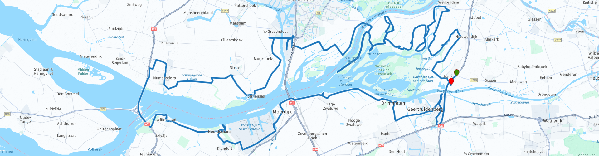
187.70 km

Countries

 RouteXpert Review
 The skyline of Geertruidenberg is dominated by the huge Amercentrale. After that, rurality prevails in the Bergsepolder. On the edge of it, on the Amer, lies Drimmelen, the front garden of the Biesbosch. In the marina with the Biesbosch information center you can rent boats to take out on the water, but we stay on the land covered with strips of asphalt. Drimmelen is a beautiful town with old facades along the narrow cobbled street and there is also a duck decoy along the road, which used to catch ducks in the Biesbosch. The use of duck decoys has ended in the Biesbosch, even the fishing industry has shrunk sharply here. Many different reed mat makers used to be located around the Biesbosch. Reed was used to make roof coverings and chair seats, among other things. Willow branches were also harvested for various purposes. Now that's all museum stuff.
After Drimmelen the wide polder swallows up man and motorcycle again up to Lage Zwaluwe and Moerdijk. They both also have a harbour, but one with more work barges than pleasure boats. You would sometimes almost forget that people still work in the Netherlands. Of course we drive as close as possible along the water, past the Outer Harbor of Lage Zwaluwe on the Biesboschweg. At the end of it, a recreational area has emerged from the marshy ground: with the Beach Bosch club at the water's edge. Nice pun! Next to it is a cannon that the Germans left behind in 1945. During their invasion in May 1940, the Germans captured the bridges over the Hollands Diep, between Lage Zwaluwe and the island of Dordrecht and later from Moerdijk to Strijen, intact. The Allies were unable to disable the bridges. When the Germans withdrew north of the Hollands Diep at the end of 1944, they blew up the bridges behind them. And left this cannon behind. The Oostdijk takes you to Willemstad, where it is important to get back to the other bank of the Haringvliet. For this purpose, the A29 was built on the Haringvliet bridge, a number of pillars of which stand on a worm-shaped appendage of the island of Goeree Overvlakkee. At 's Gravendeel another bridge takes you over the Dordtsche Kil to Dordrecht, the oldest city in Holland. With the Elizabethan Flood of 1421, the city lost all its fertile arable land in one fell swoop, and Dordrecht suddenly found itself on the sea. 'The Venice of the North' was surrounded by water on all sides and dikes had to be built and new land reclaimed from the water. Polder roads take you across the current island of Dordrecht to the Stoopbank on the Noorder Elsweg. That's a monument
more of a viewing hill, constructed in 1930 as a reminder of the efforts of Th. Stoop as a board member of the Vereeniging de Biesbosch, which shaped the Bieschboschpolder. That association was founded in 1924 to carry out the reclamation with unemployed people from Dordrecht. The work took place in phases, after the closure of the last dike in 1926 the construction of roads and making the land suitable for agriculture began. And now part of that agricultural land is being transformed into a nature reserve. After centuries of laborious work had turned water into land, farmers were bought out at the beginning of this century and lands were depolluted to make room for the rivers again. Since 1994, the Biesbosch, the largest freshwater delta in Europe according to the museum, has also been a national park.
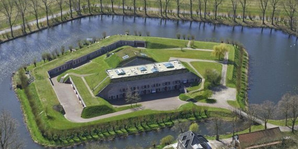
This polder is also a pleasure to drive through. The Zeedijk takes you to the waypoint with the striking name Kop van 't Land. Here we have to cross the water again, the Nieuwe Merwede in this case and we do that in a real expedition atmosphere with a ferry. On the other side, the Biesbosch, the most mysterious jungle in the Netherlands, a twilight zone between water and land. On the Brabantse Oever, a system of roads takes you to the Biesbosch Museum Island, at the Gat van den Kleinen Hil. The motorcycle goes on the side stand, helmets disappear into the museum lockers. You immerse yourself in the interesting exhibition in the museum, where your knowledge about the Biesbosch is quickly updated. And nowadays that is very different than with just a colored school poster on which the geography teacher haphazardly taps with a stick, while mumbling barely intelligible sentences in archaic Dutch into his gag. And then it's time for the cruise. With a pleasantly chatting skipper at the helm, we sail deeper and deeper into the jungle. Water sports enthusiasts in all kinds of boats, water birds, trees, shrubs and reeds glide past, as if we were sailing on the mighty Brazilian Orinoco or the equally mighty Danube Delta. A Beaver, living again since 1988
in the area, we haven't seen it, apart from that stuffed specimen in the museum, but you can't have everything. After this educational and entertaining intermezzo you continue through the Heart of Borneo, well the Dutch equivalent of it, full of creeks and strips of land with shrubs on them. What kind of natives are hiding there with blowguns and poison arrows? Fortunately, the road surface here is also provided with a reassuring layer of Dutch quality asphalt, so that we can keep up the momentum. Here and there signs warn of mud or water on the road, but there doesn't seem to be much more danger lurking here. The Biesbosch is not just there for recreation. Obviously we can't drive around everywhere on a motorcycle. Because of all that water, nature conservation and those beavers of course. But to be honest, we are pleasantly surprised that, after the boat trip, we also get a beautiful view of the Biesbosch from the saddle. More than we hoped for, to be honest. We meander along roads between wrecked land and swampy water. Yes, it's quite beautiful. From personal experience we can compare the Biesbosch with the Danube Delta and then our Biesbosch has two advantages. Because Tulcea in Romania is a long way further away than Hank and Dussen. And you can experience much less of it on a motorcycle.
Just as picturesque fishing villages only exist for tourists, the Biesbosch has also been cultivated around the image of a mysterious and impenetrable area, where you can get hopelessly lost if you don't know your way around.
fisherman, cane cutter or partisan. If you are looking for unspoilt nature in the Netherlands, you have to go to the water. That is a bit difficult with a motorcycle, but the trick is to explore the edges in an area like the Biesbosch, where you are still allowed to ride, but where you can also feel the rugged nature up close.
During the Second World War, the Biesbosch was a shelter for people in hiding and resistance fighters. The Germans did not dare to enter the Biesbosch: afraid of getting lost in the watery area with all kinds of winding creeks, reed collars and osier trees, which also has different water levels every day. Umheimisch Gebiet, ideal for hiding things such as ships and a transit area for smugglers, people in hiding, resistance fighters and
downed Allied pilots. And to top it all off: German deserters. A number of Biesbosch partisans captured German refugees who had fled in November 1944 and later handed them over to the Polish liberators. In the last year of the war, when the south had already been liberated, the so-called line crossers passed through the Biesbosch and did very important work. Not only did they transfer people, weapons, equipment and messages, but also large quantities of medicine.

 Links
Links  Usage
Usage Want to download this route?
You can download the route for free without MyRoute-app account. To do so, open the route and click 'save as'. Want to edit this route?
No problem, start by opening the route. Follow the tutorial and create your personal MyRoute-app account. After registration, your trial starts automatically.  Disclaimer
Use of this GPS route is at your own expense and risk. The route has been carefully composed and checked by a MyRoute-app accredited RouteXpert for use on TomTom, Garmin and MyRoute-app Navigation.
Changes may nevertheless have occurred due to changed circumstances, road diversions or seasonal closures. We therefore recommend checking each route before use.
Preferably use the route track in your navigation system. More information about the use of MyRoute-app can be found on the website under 'Community' or 'Academy'.