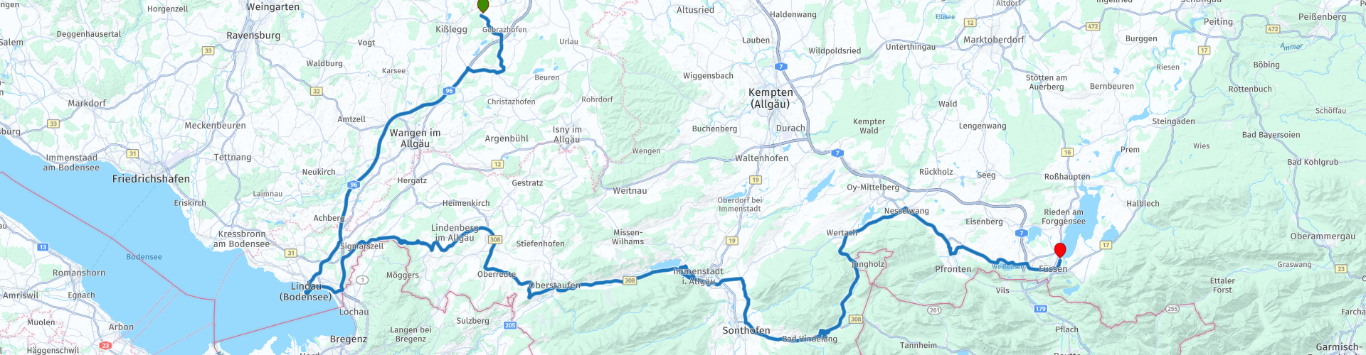
Kisslegg to Fussen

Diese Route wurde erstellt von:
RouteXpert Marcel Scherpenkate
Letzte Änderung: 11-01-2024
 Routenzusammenfassung
 Die Route wurde für Benutzer der Navigation von TomTom, Garmin und MyRoute-App ausgeglichen.
Ich bewerte diese Route mit der maximalen Anzahl von 5 Sternen, ich durfte diese Route selbst fahren und sie ist eine Folge von Landschaftsvielfalt über wunderschöne Straßen, die durch gleichermaßen authentische Dörfer und Panoramablicke verbunden sind. Wunderbar durchzufahren.
 Diese Route teilen


Animation

Urteil


Dauer
6h 44m

Reisemodus
Auto oder Motorrad

Entfernung
172.34 km

Länder


 RouteXpert-Überprüfung
 Wenn Sie Hüte mögen, ist das Hutmuseum in Lindenberg im Allgäu ebenfalls ein Besuch wert. Die erste Hutfabrik wurde in der Biedermeierzeit (1814-1840) gegründet. Bis 1890 gab es 34 Strohhuthersteller, die zusammen jährlich etwa 8 Millionen Strohhüte herstellten. Es ist daher nicht verwunderlich, dass Lindenberg in den frühen 1920er Jahren als das Herz der deutschen Strohhutindustrie "Little Paris" bezeichnet wurde. Das Hutmuseum gibt einen schönen Einblick in die jahrhundertealte Tradition der Hutmacherei in der Stadt. Die Route führt weiter auf der B308, wo Sie bei gutem Wetter einen fantastischen Blick über den gesamten nationalen Nagefluhkettenpark haben. Auf dem Grat zwischen Weiler und Simmerberg sieht man bei klarem Wetter nicht nur das Allgäu- und das Vorarlgebirge, sondern auch das Schweizer Santis-Massiv. Die Passstraße Oberjoch beginnt ebenfalls im Dorf Oberreute. Diese Straße führt Sie nach einer Stunde Lenkung in das kleine Dorf Bühl am Alpsee, wo Sie am Großen Alpsee, dem größten Natursee des Allgäu, zu Mittag essen können. Vom Gasthof Alpsee lohnt es sich, durch den kleinen Hafen in Richtung Alpsee mit seinem langen Steg zu laufen, auf dem Sie mehrere zehn Meter in den Alpsee laufen können. Nach dieser Haltestelle geht es weiter durch das Oberallgäu und Sie fahren über Immenstadt, Sonthofen nach Bad Hindelang. Bad Hindelang ist nicht nur ein modernes Skigebiet (Oberjoch), sondern auch ein Spa. Wer an Allergien leidet, kann hier mit gesunder Luft und unberührter Natur frei atmen und einen unbeschwerten Urlaub genießen. Darüber hinaus wurden seit 2011 mehr als 110 Unternehmen in Bad Hindelang als „allergikerfreundlich“ anerkannt. Im Jahr 2019 verlieh das bayerische Heilbäder-Verband Bad Hindelang das TÜV-Siegel des „Kurortes für Allergiker“. Nach Bad Hindelang beginnt die Oberjoch-Passstraße und ist eine der bekanntesten Erholungsrouten Bayerns. Es ist Deutschlands kurvenreichste Straße durch die Alpen. Dieser Teil besteht aus 106 Windungen. Die Straße ist so gut in die Farmlandschaft integriert, dass sie wie die Nachbardörfer und Berge zu einem untrennbaren Bestandteil geworden ist und wirklich fantastisch zu fahren ist. Tipp: Vergessen Sie nicht, die schöne Aussicht zu genießen, die auf einem der vielen Parkplätze mit fantastischer Aussicht möglich ist. Schließlich erreichen Sie Wertach am Grüntensee, einem 2,5 km langen und 11,2 m tiefen Stausee mit einem Umfang von 8,2 km. Der Stausee wurde 1962 fertiggestellt und dient dem Hochwasserschutz und der Stromerzeugung. Pfronten, das nächste Dorf auf Ihrer Route nach Nesselwang, widmet sich der Heilkraft des Heus. Dies kommt ausschließlich von nicht grasenden und unbefruchteten Bergwiesen, die auf einer Höhe von mehr als 900 Metern liegen. Die unerschöpfliche Heilkraft des Heus von den Bergwiesen mit siebzig verschiedenen Arten von Kräutern, Gräsern und Heilpflanzen wird auf vielfältige Weise genutzt.
Wenn Sie den Weißensee entlang fahren, sehen Sie bereits das heutige Endziel, Füssen, die höchste Stadt Bayerns. Es liegt am Fluss Lech auf 833 Metern über dem Meeresspiegel. Die Stadt hat 15.608 Einwohner. Die romantische Altstadt von Füssen hat eine italienische Atmosphäre. Die Plätze und Straßencafés laden Sie ein, nach einem Tag auf dem Motorrad einen Besuch abzustatten. Sie fahren durch die Stadt zum Hotel Sommer, wo Sie am Forgensee übernachten können.


 Links
Links  Nutzung
 Möchten Sie diese Route herunterladen?
Sie können die Route ohne MyRoute-App-Konto kostenlos herunterladen. Öffnen Sie dazu die Route und klicken Sie auf 'Speichern unter'. Möchten Sie diese Route bearbeiten?
Kein Problem, starten Sie mit dem Öffnen der Route. Folgen Sie dem Tutorial und erstellen Sie Ihr persönliches MyRoute-App-Konto. Nach der Registrierung startet Ihre Testversion automatisch.  Haftungsausschluss
Die Nutzung dieser GPS-Route erfolgt auf eigene Kosten und Gefahr. Die Route wurde sorgfältig von einem MyRoute-App akkreditierten RouteXpert für die Verwendung mit TomTom, Garmin und MyRoute-App Navigation zusammengestellt und geprüft.
Durch geänderte Umstände, Straßenumleitungen oder saisonale Sperren können sich dennoch Änderungen ergeben haben. Wir empfehlen daher, jede Route vor der Nutzung zu überprüfen.
Verwenden Sie vorzugsweise den Routentrack in Ihrem Navigationssystem. Mehr Informationen zu den Die Nutzung der MyRoute-App finden Sie auf der Website unter 'Community' oder 'Academy'.

Bayern
Über diese Region
Der Freistaat Bayern ([ˈbaɪ̯ɐn] ; Ländercode BY), kurz Bayern, ist das flächengrößte der 16 Länder der Bundesrepublik Deutschland und liegt in deren Südosten. Mit rund 13,2 Millionen Einwohnern ist er das zweitbevölkerungsreichste deutsche Land. Die Landeshauptstadt und bevölkerungsreichste Stadt ist München mit rund 1,5 Millionen Einwohnern.
Der Freistaat hat im Süden Anteil am Hochgebirge der Ostalpen und an dem bis zur Donau reichenden flachen Alpenvorland. Nördlich der Donau bestimmen Mittelgebirge wie der Bayerische Wald oder das Fichtelgebirge das Landschaftsbild.
Seine staatsrechtliche Ordnung beruht auf der Verfassung des Freistaates Bayern. Die Bezeichnung Freistaat trägt Bayern seit 1918 mit der Ausrufung als Republik und dem damit verbundenen Ende des Königreichs Bayern.
Bereits im Jahre 555 n. Chr. und damit rund 500 Jahre vor der Verwendung des Begriffs deutsch im heutigen Sinn ist das ältere bayerische Stammesherzogtum nachgewiesen, das Teil des fränkischen Herrschaftsbereichs wurde. Unter den Karolingern entstand erstmals ein baierisches Königtum. Nach dem Ende der Herrschaft der Karolinger erstarkte die baierische Eigenständigkeit im jüngeren bayerischen Stammesherzogtum. Mit Beginn der Herrschaft der Wittelsbacher 1180 folgte der Übergang zum Territorialstaat. Sie regierten Bayern über 700 Jahre bis 1918. Baiern war Kurfürstentum des Heiligen Römischen Reiches und ab 1806 Königreich. Durch die Verfassungen von 1808 und 1818 wurde Bayern konstitutionelle Monarchie. Bayern konnte auf dem Wiener Kongress 1814 als eine der Siegermächte einen großen Teil der Gebietsgewinne behalten; unter anderem kamen Teile Frankens, Schwabens und die neugeschaffene linksrheinische Pfalz zu Bayern. 1918 brach die Wittelsbachermonarchie in der Novemberrevolution zusammen. In der Weimarer Republik verlor Bayern seine Reservatrechte weitgehend zugunsten des Reichs. Nach der NS-Machtergreifung erfolgte schrittweise die Aushebelung sämtlicher politischen Möglichkeiten Bayerns, so des Bayerischen Landtags, aber auch der bayerischen Staatsbürgerschaft. Die Amerikanische Besatzungsmacht stellte Bayern 1945 offiziell wieder als unabhängigen Staat her. Die Pfalz wurde 1946 von Bayern abgetrennt und ist heute Teil von Rheinland-Pfalz. 1949 gründete der Freistaat unter Vorbehalten die Bundesrepublik mit.
Traditionell gliedert es sich in die drei Landesteile und „Stämme“ Altbayern (Bezirk und Regierungsbezirk Oberpfalz, Ober- und Niederbayern), Franken (Ober-, Mittel- und Unterfranken) und Schwaben. Die Heimatvertriebenen aus den ehemaligen deutschen Ostgebieten werden als vierter Stamm bezeichnet.
Lesen Sie mehr auf Wikipedia
Der Freistaat hat im Süden Anteil am Hochgebirge der Ostalpen und an dem bis zur Donau reichenden flachen Alpenvorland. Nördlich der Donau bestimmen Mittelgebirge wie der Bayerische Wald oder das Fichtelgebirge das Landschaftsbild.
Seine staatsrechtliche Ordnung beruht auf der Verfassung des Freistaates Bayern. Die Bezeichnung Freistaat trägt Bayern seit 1918 mit der Ausrufung als Republik und dem damit verbundenen Ende des Königreichs Bayern.
Bereits im Jahre 555 n. Chr. und damit rund 500 Jahre vor der Verwendung des Begriffs deutsch im heutigen Sinn ist das ältere bayerische Stammesherzogtum nachgewiesen, das Teil des fränkischen Herrschaftsbereichs wurde. Unter den Karolingern entstand erstmals ein baierisches Königtum. Nach dem Ende der Herrschaft der Karolinger erstarkte die baierische Eigenständigkeit im jüngeren bayerischen Stammesherzogtum. Mit Beginn der Herrschaft der Wittelsbacher 1180 folgte der Übergang zum Territorialstaat. Sie regierten Bayern über 700 Jahre bis 1918. Baiern war Kurfürstentum des Heiligen Römischen Reiches und ab 1806 Königreich. Durch die Verfassungen von 1808 und 1818 wurde Bayern konstitutionelle Monarchie. Bayern konnte auf dem Wiener Kongress 1814 als eine der Siegermächte einen großen Teil der Gebietsgewinne behalten; unter anderem kamen Teile Frankens, Schwabens und die neugeschaffene linksrheinische Pfalz zu Bayern. 1918 brach die Wittelsbachermonarchie in der Novemberrevolution zusammen. In der Weimarer Republik verlor Bayern seine Reservatrechte weitgehend zugunsten des Reichs. Nach der NS-Machtergreifung erfolgte schrittweise die Aushebelung sämtlicher politischen Möglichkeiten Bayerns, so des Bayerischen Landtags, aber auch der bayerischen Staatsbürgerschaft. Die Amerikanische Besatzungsmacht stellte Bayern 1945 offiziell wieder als unabhängigen Staat her. Die Pfalz wurde 1946 von Bayern abgetrennt und ist heute Teil von Rheinland-Pfalz. 1949 gründete der Freistaat unter Vorbehalten die Bundesrepublik mit.
Traditionell gliedert es sich in die drei Landesteile und „Stämme“ Altbayern (Bezirk und Regierungsbezirk Oberpfalz, Ober- und Niederbayern), Franken (Ober-, Mittel- und Unterfranken) und Schwaben. Die Heimatvertriebenen aus den ehemaligen deutschen Ostgebieten werden als vierter Stamm bezeichnet.
Region anzeigen
 Statistik
  42
42Anzahl der RX-Bewertungen (Bayern)
 30983
30983Anzahl der Besucher (Bayern)
 4847
4847Anzahl der Downloads (Bayern)
 Routensammlungen in dieser Region
 Die 24 schönsten Alpenrouten
Die Alpen, Die Alpen sind ein Gebirge in Europa, das sich von der französischen Mittelmeerküste im Südwesten bis zur Pannonischen Tiefebene im Osten erstreckt. Die Fläche des Gebirges beträgt mehr als 200.000 km².
Mit anderen Worten: Pässe und Bergstraßen!
Durch die Berge zu fahren ist toll! Vor allem über die Bergpässe mit Spitzkehren und engen Serpentinen. Jede Kurve eine andere Aussicht, die Sie genießen können. In den Alpen gibt es viele schöne Pässe.
Eine Auswahl, die auch in diese Routen eingeflossen ist:
Der Stlevio-Pass:
Das Stilfser Joch, auch Passo dello Stelvio genannt, ist vor allem für die Etappe des Giro d'Italia bekannt. Aufgrund der Länge und des Höhenunterschieds gilt dieser Pass als eine der härtesten Prüfungen im Radsport. Das Stilfser Joch erreicht eine maximale Höhe von 2758 Metern und ist damit einer der höchsten der Alpen. Der Pass verbindet die Städte Bormio und Prato Allo Stelvio. Im Winter ist der Pass wegen starkem Schneefall gesperrt.
Der Reschenpass:
Der Reschenpass, auch Reschenpass genannt, verbindet das österreichische Bundesland Tirol mit dem italienischen Bundesland Südtirol. Der Pass erreicht eine maximale Höhe von 1.504 Metern und war in den letzten Jahrhunderten eine der wichtigsten Nord-Süd-Verbindungen der Alpen. Der Pass wurde lange vor der Römerzeit benutzt. Unterwegs passieren Sie mehrere Highlights und historische Relikte. Einer der Höhepunkte ist der Reschensee. Dieser See entstand nach dem Bau des Staudamms und hat das Dorf Graun vollständig überflutet. Daran erinnert nur der Glockenturm mitten im See.
Col du Galibier:
Der französische Pass Col du Galibier verbindet die Städte Saint-Michel-de-Maurienne und Briançon über den Col du Lautaret im Süden und den Col du Télégraphe im Norden. Der Pass ist Teil der Tour de France und sehr gefürchtet, da er nur über die beiden anderen Passstraßen zu erreichen ist. Der Pass erreicht eine maximale Höhe von 2646 Metern. Von dort aus kann man zum Aussichtspunkt auf 2704 Metern wandern. Hier können Sie die Gipfel des Grand Galibier, Mont Blanc und La Meije bewundern.
Die Großglockner Hochalpenstraße:
Mit einer Höhe von 3798 Metern ist der Großglockner der höchste Berg Österreichs. Um diesen imposanten Berg in vollen Zügen genießen zu können, können Sie über die Großglockner Hochalpenstraße und den dazugehörigen Pass fahren. Die Route startet in Bruck am Großglockner und endet in Heiligenblut. Natürlich können Sie in zwei Richtungen fahren. Der Pass erreicht eine maximale Höhe von 2504 Metern und ist im Winter wegen starkem Schneefall gesperrt. Unterwegs passieren Sie mehrere Stationen mit lustigen Aktivitäten, Infopunkten, Berghütten und Aussichtspunkten. Ein Besuch der Kaiser-Franz-Josefs-Höhe und des Pasterzengletschers ist sehr zu empfehlen.
Der Col d'Izoard:
Ebenso wie der Col du Galibier ist auch der Col d'Izoard Teil einer Etappe der Tour de France. Der Gebirgspass verbindet Briançon mit dem Tal des Flusses Guil. Der Pass liegt teilweise im Regionalen Naturpark du Queyras und erreicht eine maximale Höhe von 2360 Metern. Das Besondere am Col d'Izoard ist die karge und felsige Landschaft. Manchmal fühlt es sich an, als würde man mit einem Auto über den Mond fahren! Unterwegs können Sie an mehreren Stellen anhalten, um die schöne Aussicht zu genießen.
Der Berninapass:
Der Bernina Express ist einer der bekanntesten Bahnzüge der Schweiz und der Alpen. Die Route ist wunderschön und teilweise in die UNESCO-Welterbeliste aufgenommen. Parallel zur Bahn liegt der Berninapass, der das Veltlintal mit dem Egandintal verbindet. Diese wunderschöne Alpenstraße hat eine Gesamtlänge von 56 Kilometern und erreicht eine maximale Höhe von 2328 Metern. Unterwegs genießen Sie die Aussicht auf den Morteratschgletscher.
Der Sellajoch:
Der Sellajoch, auch Sellajoch genannt, führt Sie über eine der beeindruckendsten Bergketten der Dolomiten: das Sellamassiv. Der Pass verbindet das Fassatal mit dem Grödnertal und erreicht eine maximale Höhe von 2236 Metern. Auf dieser Höhe liegt auch die Grenze der italienischen Provinzen Trentino und Bozen. Unterwegs genießen Sie die Aussicht auf diese spektakuläre Bergwelt. Bewundern Sie beispielsweise die drei Gipfel des Sasso-Lungo-Massivs, des Sella-Massivs oder die Gipfel der Marmolada. Sie können den Sellapass auch in Kombination mit dem Grödnerjoch, Pordoijoch und Campolongopass fahren.
Der Grimselpass:
Der Grimselpass verbindet das Goms im Wallis mit dem Halistal im Berner Oberland. Der Pass erreicht eine maximale Höhe von 2165 Metern und ist im Winter wegen Schneefall gesperrt. Im Laufe der Jahrhunderte spielte der Gebirgspass eine wichtige Rolle im Handel zwischen der Schweiz und Italien. Jetzt sind es vor allem die Stauseen, die eine wichtige Funktion haben. Diese dienen der Stromerzeugung. Die Landschaft, durch die Sie fahren, ist zerklüftet, felsig und beeindruckend. Oben auf dem Pass befindet sich ein Hotel und ein Restaurant mit einem besonderen Murmeltierpark. Hier befindet sich auch der Dodensee (Totensee). Dieser See verdankt seinen Namen den vielen Soldaten, die zur Zeit Napoleons starben.
Der Gotthardpass:
Der Gotthardpass, auch Passo del San Gottardo und St. Gotthard genannt, verbindet die Schweizer Städte Airolo und Andermatt. Der Pass und der dazugehörige Tunnel sind vor allem bei Urlaubern bekannt, die aus der Schweiz nach Italien fahren. Doch wo sich die Mehrheit für den Tunnel entscheidet, ist es gerade der Pass, der den Urlaub erst richtig abrundet. Der Gotthardpass hat eine Länge von rund 26 Kilometern und erreicht eine maximale Höhe von 2106 Metern. Die Route ist wunderschön und führt Sie entlang alter Dörfer und schöner Aussichten.
Silvretta Hochalpenstraße und Silvrettapass:
Das Paznauntal in Tirol und das Montafon in Vorarlberg sind durch die Silvretta Hochalpenstraße verbunden. Die Strecke hat eine Länge von 22,3 Kilometern und führt von Galtür nach Partenen in 34 Kehren, über die 2032 Meter hohe Bielerhöhe. An dieser Stelle befindet sich auch der Silvrettasee, der zu einem schönen Spaziergang einlädt. Im Winter ist der Pass wegen Schneefall geschlossen.
Der Simplonpass:
Genau wie der Gotthardpass reisen auch viele Urlauber jedes Jahr über den Simplonpass. Dieser Pass verbindet das Rhonetal im Kanton Wallis mit dem Valle d'Ossola im Piemont. Der Pass ist ganzjährig geöffnet und erreicht eine maximale Höhe von 2005 Metern. Unterwegs passieren Sie eine Reihe von Gebäuden, darunter das bekannte Simplon Hospiz aus dem Jahr 1825. Das Hospiz wird von den Mönchen von St. Bernhard geführt. Vom höchsten Punkt des Passes sind alle Arten von Wanderrouten möglich und Sie werden auch auf ein Hotel treffen, in dem Sie übernachten können.
Der Gerlospass:
Der Gerlospass verbindet das Salzachtal im Salzburgerland mit dem Zillertal in Tirol. Der Pass ist Teil der Gerlos Alpenstraße und führt mitten durch den Nationalpark Hohe Tauern. Unterwegs genießen Sie schöne Ausblicke auf die Umgebung. Der Pass hat eine Länge von 12 Kilometern und erreicht eine maximale Höhe von 1531 Metern. Eine Fahrt über den Gerlospass lässt sich ideal mit einem Besuch der Krimmler Wasserfälle kombinieren.
Der Grosse St. Bernhard Pass:
Der Grosse St. Bernhard, besser bekannt als Col du Grand Saint Bernard, verbindet die italienische Provinz Valle d'Aosta mit dem Schweizer Kanton Wallis. Der Pass ist einer der höchsten der Schweiz und erreicht eine maximale Höhe von 2469 Metern. Wie viele andere Bergpässe in dieser Liste wird auch der Grosse St. Bernhard seit Jahrhunderten als Verbindungsstrasse genutzt. Der Pass ist nach den Bernhardinern benannt, die zusammen mit den Mönchen gestrandeten Reisenden halfen. Der Pass ist im Winter geschlossen.
Die Timmelsjoch Hochalpenstraße:
Die Timmelsjoch Hochalpenstraße verbindet die Orte Sölden im Ötztal und Meran in Südtirol. Auf der Strecke Hochgurgl - Moos ist Maut zu entrichten. Über eine Bergstraße mit ca. 60 Kehren fährst du durch eine wunderschöne Bergwelt. Beim Timmelsjoch Erlebnis erfahren Sie an verschiedenen Stationen mehr über die Geschichte, die Straße und die Umgebung. Sie können auch das Top Mountain Crosspoint Museum besuchen.
Col de l'Iseran:
Mit einer maximalen Passhöhe von 2770 Metern ist der Col l'Iséran einer der höchsten Gebirgspässe der Alpen. Der Pass verbindet Bourg-Saint-Maurice mit Bonneval-sur-Arc. Über eine Straße voller Haarnadelkurven passieren Sie unter anderem Val-d'Isère und ein Seitental der Maurienne, das vollständig im Nationalpark de la Vanoise liegt. Sie können Tiere wie Murmeltiere und Gämsen beobachten und oben auf dem Pass befindet sich ein Restaurant mit Kapelle.
Der Gavia-Pass:
Der Gaviapass (italienisch Passo di Gavia) ist ein Gebirgspass in den italienischen Alpen in der Lombardei.
Sie ist eine der höchsten Passstraßen Europas. Die Straße führt durch den unberührten Nationalpark Stilfser Joch. Die Straße wurde im Ersten Weltkrieg gebaut, um italienische Soldaten zu versorgen, die im italienisch-österreichischen Grenzgebiet kämpften. Die Passhöhe ist eine der schönsten in den Alpen. Hier ist der große Lago Bianco mit im Norden der Berg San Matteo (3684 Meter). Etwas tiefer liegt der Lago Nero auf der Südseite des Passes. Hier bestimmt die Berggruppe des Adamello die Aussicht. Es gibt viele gut markierte Wanderwege in der Umgebung. Im Winter ist der Pass wegen des starken Schneefalls gesperrt. Aufgrund der großen Schneemenge ist der Pass oft bis Mai und Juni gesperrt.
Promoter hat eine Auswahl der 24 schönsten Alpenrouten getroffen, die sie in den letzten Jahren erstellt haben.
Die Routen führen durch:
Frankreich
Österreich
Schweiz
Italien
Die schönsten Straßen, die schönsten Aussichten, die schönsten Aussichtspunkte. Die höchsten Berge, die schnellsten Abfahrten, Haarnadelkurve um Haarnadelkurve, man kann nicht genug bekommen.
Wenn Sie in dieser Region Urlaub machen, profitieren Sie davon, ALLE Routen in dieser Sammlung wurden von einer MyRoute-App RouteXpert geprüft und für TomTom, Garmin und MyRoute-App Navigation gleichgestellt.
Viel Spaß mit dieser Sammlung und beim Fahren einer dieser Strecken. Genießen Sie die Schönheit der Alpen und Dolomiten. Klicken Sie auf „Route anzeigen“, um die Bewertung der ausgewählten Route zu lesen.
Ich würde gerne Ihre Erkenntnisse über die Route(n) hören.
Routensammlung anzeigen
11-tägiger Ausflug aus den Niederlanden
8 Länder in 11 Tagen; Niederlande, Deutschland, Österreich, Italien, Schweiz, Frankreich, Luxemburg und Belgien. Diese Streckensammlung besteht aus 10 Strecken, die ich im Sommer 2019 mit Freunden gefahren bin.
Der Start ist in Geldermalsen Niederlande, die ersten 7 Tage fahren Sie durch die Niederlande, Deutschland, Österreich, Italien, die Schweiz, Frankreich und ein Stück Luxemburg mit Übernachtungen in Hotels.
Die letzten drei Tage bleiben Sie in Barweiler (D) in der Eifel und fahren zwei wunderschöne Touren durch die Eifel, Luxemburg und Teile der belgischen Ardennen.
Es gibt keine Autobahn in den Routen, nur schöne Provinz- und Landstraßen, viele schöne Pässe mit schönen Panoramen.
Überprüfen Sie vor Ihrer Abreise, ob die Pässe geöffnet sind.
Dies sind Routen für erfahrene Fahrer.
Routensammlung anzeigen