TTT 2014 03 Maastricht Margraten

This route was brought to you by:
RouteXpert Hans van de Ven (Mr.MRA)
Last edit: 22-12-2019
 Route Summary
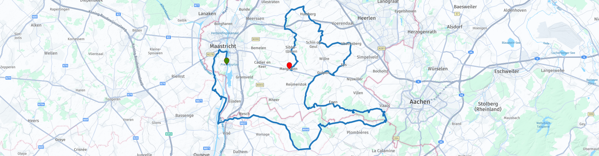
 The 173 ANWB Promoter TankTasTocht (TTT) were scanned by Henry ten Dam and signed by Leon Stolk in Mapsource and later placed as a Track in a .gpx file. These have been made available through the MrGPS website with the approval of the ANWB Promoter so that everyone can enjoy it. The 1st TTT is from 1992, so the route may differ slightly from the original.
I have checked all route points and, where necessary, placed them on the road. Also, if necessary, I have further spaced the start point and end point of the route to avoid navigating directly to the end point and I added the POI files from the start and end point just like a possible stopping point.
Finally, I made the route the same for TomTom, Garmin and MyRoute-app Navigation users.
Thanks to Henry, Leon, MrGPS and Promoter.
 Share this route


Animation

Verdict


Duration
2h 51m

Mode of travel
Car or motorcycle

Distance
110.80 km

Countries


 RouteXpert Review
 After a little less than 7 KM you leave the Netherlands to enter Belgium and you quickly cross the Albert Canal twice, this is a channel that connects Liege with Antwerp via cities such as Genk, Hasselt, Geel and Herentals, and the Maas with the Scheldt . Then you cross the Maas, this is a 950 kilometer long river in Western Europe. The Meuse rises in France and then flows through Belgium and the Netherlands. In the Netherlands, the Maas is the southernmost of the major rivers and flows into the North Sea in the Dutch river delta.
We stay in Belgium for a while and pass Castle Commanderie among others, hidden in the idyllic Belgian Voeren region lies Castle Commanderie. Because of its rich history that goes back to the beginning of the 17th century and the fact that the River Vo originates on the 12 hectare domain, Kasteel Commanderie is the icon of the Voeren region.
After 51 KM we enter the Netherlands again at the 3-Country Point in Vaals. The Three Country Point at Vaals is the highest point in the Netherlands and a place where the borders between the Netherlands, Belgium and Germany come together.
You can stop for lunch or all for a drink at Lodge-7 in Vaals, this is a nice point on the route where you can see the tower of the 3-Land Point from the terrace in good weather.
Be careful when entering the parking space, it is covered with a layer of pebble!
After lunch we will continue to wind through the South Limburg country and you will pass the Geul, 3 times and the Gulp, the Geul is a river that originates in the municipality of Raeren in Belgium at the Cyclops stones on the German border, near the place Lichtenbusch. She leaves Belgium at Sippenaeken and enters the Netherlands at Cottessen. At the hamlet of Voulwames above Itteren, it flows into the Maas. De Gulp is a fast-flowing side stream of the Geul in a hilly region in the Belgian provinces of Liège and Limburg, more specifically the Vola exclave and the south of Dutch Limburg.
In Margraten you can visit the American cemetery after finishing the route with a cup of coffee. The American Cemetery Margraten, in English: Netherlands American Cemetery and Memorial, is an American military cemetery and memorial to the deceased soldiers of the United States of America at the time of the battle in South Limburg, the Ardennes offensive and in the Ruhr area , during the Second World War. The cemetery has an area of 26.5 hectares, contains 8,301 graves, was founded in 1944 and is freely accessible.
Because I have driven large parts of this route myself, this route gets 4 stars.
Route details:
rp 19 - Coffee / Lunch stop at Lodge 7 in Vaals.


 Links
Links  Usage
Usage Want to download this route?
You can download the route for free without MyRoute-app account. To do so, open the route and click 'save as'. Want to edit this route?
No problem, start by opening the route. Follow the tutorial and create your personal MyRoute-app account. After registration, your trial starts automatically.  Disclaimer
Use of this GPS route is at your own expense and risk. The route has been carefully composed and checked by a MyRoute-app accredited RouteXpert for use on TomTom, Garmin and MyRoute-app Navigation.
Changes may nevertheless have occurred due to changed circumstances, road diversions or seasonal closures. We therefore recommend checking each route before use.
Preferably use the route track in your navigation system. More information about the use of MyRoute-app can be found on the website under 'Community' or 'Academy'.