Day 01 Silk Road Amsterdam Winterberg

This route was brought to you by:
RouteXpert René Plücken (MRA Master)
Last edit: 26-04-2022
 Route Summary
 For centuries, from classical antiquity to the late Middle Ages, the Silk Road was the main link between East and West.
Along the routes people were able to transport commodities, especially luxury goods such as silk, satin, musk, rubies, diamonds, pearls and porcelain, as well as paper, rhubarb, fruits such as peaches and oranges, horses, camels, elephants and gunpowder. . Not only goods were transferred in this way, but also views, ideas, illnesses and cultures.
Although the term Silk Road suggests that it was one route, several routes have existed over the centuries. Also, several routes were often in use at the same time. The term gives the impression of a long journey, but in fact very few travelers made the entire route from start to finish. And because of the transport of other products, certain parts of the route also have other names, such as the Incense Route and the Tea Route.
The Silk Road can be easily driven by motorbike and there are various travel and adventure organizations that offer this long journey in their package. It is advisable to drive this trip with an (organized) group so that you can help each other along the way. The route consists of 75 separate routes that can each be driven in a day. There are several beautiful cities included in the trip where you can plan one or two extra days to explore the city, rest but also to schedule necessary maintenance on the engine.
The roads are a mix of highways, good state and local roads, but also lots of dirt roads, so an all-road/adventure bike is a must to ride these routes.
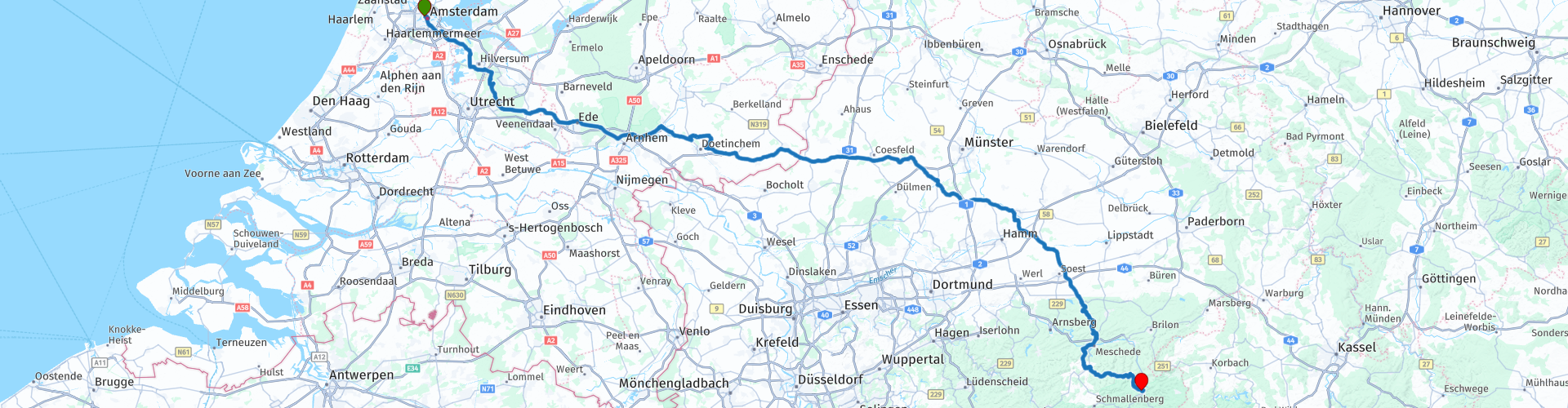
The starting point is Amsterdam, but that can of course be adjusted for everyone. The terminus of the route is in Tokyo China.
This is the first of a collection of itineraries based on the Silk Road that take us through the cities of the Silk Road.
 Share this route


Animation

Verdict


Duration
10h 9m

Mode of travel
Car or motorcycle

Distance
385.36 km

Countries


 RouteXpert Review
 This first day we drive through the Netherlands to Winterberg in Germany. The route mainly consists of provincial roads to cover the 382 kilometers within an acceptable time. For enthusiasts it is possible to drive more rural roads through the Utrechtse Heuvelrug or the Veluwe. Fast drivers can also choose to drive on the A1, A30, A12 and E3 motorways.
The first short stop is planned at the Pyramid of Austerlitz, a monument consisting of a grass-lined pyramid-shaped sand mound with a stone obelisk. The total height, including obelisk, is 33 meters. Visitors can reach the platform near the obelisk along a stairway of 81 steps.
We drive past the Hoge Veluwe National Nature Park to the Hanseatic city of Doesburg, a city and municipality in the Dutch province of Gelderland with 11,096 inhabitants, which is worth a visit. The city is located on the Gelderse IJssel and the Oude IJssel. In Doesburg you imagine yourself in times gone by. The medieval street pattern has been perfectly preserved in the beautiful historic city centre. Have a cup of coffee in one of the many cafes.
The next stop is for lunch in Südlohn, Germany, just across the border, where there are a number of restaurants and snack bars. You can also refuel here, the fuel prices in Germany are considerably lower than in the Netherlands.
We drive on to Soest, where we drive into the mountains of the Sauerland. We enjoy about 70 kilometers of winding roads through the Sauerland, a mountain range in the German states of North Rhine-Westphalia and Hesse. Our final destination is Camping Hochsauerland in Winterberg. Winterberg is a well-known ski area and has several campsites and hotels. There are several beautiful routes to drive in the area, so an extra day can be planned.
I rate this route with 3 stars because it is still partly driven on normal roads and there are only a few short stops.


 Links
Links  Usage
Usage Want to download this route?
You can download the route for free without MyRoute-app account. To do so, open the route and click 'save as'. Want to edit this route?
No problem, start by opening the route. Follow the tutorial and create your personal MyRoute-app account. After registration, your trial starts automatically.  Disclaimer
Use of this GPS route is at your own expense and risk. The route has been carefully composed and checked by a MyRoute-app accredited RouteXpert for use on TomTom, Garmin and MyRoute-app Navigation.
Changes may nevertheless have occurred due to changed circumstances, road diversions or seasonal closures. We therefore recommend checking each route before use.
Preferably use the route track in your navigation system. More information about the use of MyRoute-app can be found on the website under 'Community' or 'Academy'.

North Rhine-Westphalia
About this region
North Rhine-Westphalia (German: Nordrhein-Westfalen, pronounced [ˌnɔʁtʁaɪn vɛstˈfaːlən] (listen); Low Franconian: Noordrien-Wesfale; Low German: Noordrhien-Westfalen; Colognian: Noodrhing-Wäßßfaale), commonly shortened to NRW (German: [ɛnʔɛʁˈveː] (listen)), is a German state (Land) in Western Germany. With more than 17.9 million inhabitants, it is the most populous state of Germany. Covering an area of 34,084 square kilometres (13,160 sq mi), it is the fourth-largest German state by size. Apart from the city-states, it is also the most densely populated state in Germany.
North Rhine-Westphalia features 30 of the 81 German municipalities with over 100,000 inhabitants, including Cologne (over 1 million), the state capital Düsseldorf, Dortmund and Essen (all about 600,000 inhabitants) and other cities predominantly located in the Rhine-Ruhr metropolitan area, the largest urban area in Germany and the third-largest on the European continent. The location of the Rhine-Ruhr at the heart of the European Blue Banana makes it well connected to other major European cities and metropolitan areas like the Randstad, the Flemish Diamond and the Frankfurt Rhine-Main Region.
North Rhine-Westphalia was established in 1946 after World War II from the Prussian provinces of Westphalia and the northern part of Rhine Province (North Rhine), and the Free State of Lippe by the British military administration in Allied-occupied Germany and became a state of the Federal Republic of Germany in 1949. The city of Bonn served as the federal capital until the reunification of Germany in 1990 and as the seat of government until 1999.
Culturally, North Rhine-Westphalia is not a uniform area; there are significant differences, especially in traditional customs, between the Rhineland region on the one hand and the regions of Westphalia and Lippe on the other. The state has always been Germany's powerhouse with the largest economy among the German states by GDP figures.
Read more on Wikipedia
North Rhine-Westphalia features 30 of the 81 German municipalities with over 100,000 inhabitants, including Cologne (over 1 million), the state capital Düsseldorf, Dortmund and Essen (all about 600,000 inhabitants) and other cities predominantly located in the Rhine-Ruhr metropolitan area, the largest urban area in Germany and the third-largest on the European continent. The location of the Rhine-Ruhr at the heart of the European Blue Banana makes it well connected to other major European cities and metropolitan areas like the Randstad, the Flemish Diamond and the Frankfurt Rhine-Main Region.
North Rhine-Westphalia was established in 1946 after World War II from the Prussian provinces of Westphalia and the northern part of Rhine Province (North Rhine), and the Free State of Lippe by the British military administration in Allied-occupied Germany and became a state of the Federal Republic of Germany in 1949. The city of Bonn served as the federal capital until the reunification of Germany in 1990 and as the seat of government until 1999.
Culturally, North Rhine-Westphalia is not a uniform area; there are significant differences, especially in traditional customs, between the Rhineland region on the one hand and the regions of Westphalia and Lippe on the other. The state has always been Germany's powerhouse with the largest economy among the German states by GDP figures.
View region
 Statistics
  136
136Amount of RX reviews (North Rhine-Westphalia)
 61741
61741Amount of visitors (North Rhine-Westphalia)
 27844
27844Amount of downloads (North Rhine-Westphalia)
 Route Collections in this region
 The 10 most beautiful car and motorcycle routes in Limburg
Limburg, who thinks of Limburg, thinks of flan, coal mines, marl and the hill country. The coal mines have been closed for almost 40 years, the last load of coal was brought up from the Oranje-Nassau coal mine in Heerlen on 31 December and, as they say, South Limburg was transformed from Black to Green and unfortunately there is still little left. view of this period.
But not only pie, marl and coal in Limburg, but also a very beautiful province to tour by car or motorcycle and enjoy all the beauty that the province of Limburg has to offer. For this, the MyRoute app RouteXpert has put together a Top 10 of Car and Motorcycle routes for you.
All routes in this collection have been checked and made equal for TomTom, Garmin and MyRoute-app Navigation by a MyRoute-app RouteXpert.
If you think, I have a very nice route that should certainly not be missing from this collection, send it to:
email: routeexpert@myrouteapp.com
Subject: New Route for the Top 10 collection Province of Limburg composed by Hans van de Ven.
The route will then be reviewed and then added to the Top 10.
To make the Top 10 also the Top 10, 1 route will have to disappear from the Top 10, you can indicate this when submitting the new route.
Have fun with this collection and while driving one of these routes. Enjoy all the beauty that the Netherlands and in particular the province of Limburg has to offer. Click on “View route” to read the review of the chosen route.
I would like to hear your findings about the route(s).
View Route Collection
Top 5 Car and Motorcycle Routes in the Eifel
The Eifel is the eastern part of the medium plateau Eifel-Ardennes. It is located north of the Moselle and west of the Rhine. The largest part is in Germany, a small part is in Belgium, in the East Cantons. The German part of Eifel is located in the federal states of North Rhine-Westphalia and Rhineland-Palatinate. The highest point is the Hohe Acht with 747 meters.
Several chains can be distinguished in the Eifel:
The northernmost part is called the Nordeifel, which in Belgium connects to the High Fens;
To the east of this is the Ahrgebirge, this part is located north of the Ahr in the Ahrweiler district;
South of the Ahr is the Hohe Eifel (or Hocheifel), of which the Hohe Acht (747 m) is the highest point, and also the highest point in the entire Eifel region;
To the west, near the Belgian border, the hills are known as Schneifel, part of the wider Snow Eifel area with peaks reaching up to 698 metres;
South and east of the Hohe Eifel is the Volcano-Eifel, a volcanic area with many crater lakes (Maare).
The southern part of the Eifel is less high. The area is bisected by streams and rivers running southwards. These streams flow into the Moselle. The largest of these rivers is the Kyll; the hills around this river are known as the Kyllwald;
In the south, the Eifel ends in the Voreifel.
In the north of the Eifel there are some large reservoirs. The largest of these is the reservoir in the Roer that was created by the construction of the Roerdal dam.
The Nürburgring is also located in the Eifel, a well-known car circuit for Formula 1 races, among other things. Since 2004, part of the north of the Eifel has become the Eifel National Park. This National Park falls entirely within the German-Belgian nature park High Fens-Eifel. Another part of the Eifel falls within the South Eifel Nature Park.
Well-known throughout the Netherlands and Belgium by car and motorcyclists, so reason enough for the MyRoute app RouteXpert to compile a Top 5 of Car and Motorbike routes for you.
All routes in this collection have been checked and made equal for TomTom, Garmin and MyRoute-app Navigation by a MyRoute-app RouteXpert.
If you think, I have a very nice route that should certainly not be missing from this collection, send it to:
email: routeexpert@myrouteapp.com
Subject: New Route for the Top 5 collection Eifel composed by Hans van de Ven.
The route will then be reviewed and then added to the Top 5. To make the Top 5 also the Top 5, 1 route will have to disappear from the Top 5, you can indicate this when submitting the new route.
Have fun with this collection and while driving one of these routes. Enjoy all the beauty that the Eifel has to offer. Click on “View route” to read the review of the chosen route.
I would like to hear your findings about the route(s).
View Route Collection