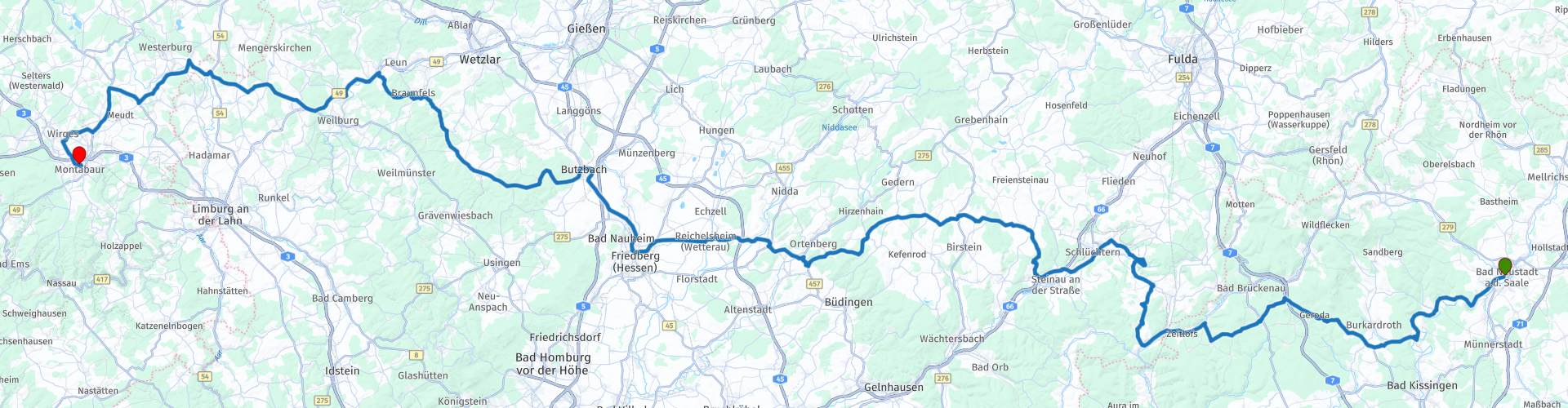
D9 Neustad an der Saale Montabaur

This route was brought to you by:
RouteXpert Albert van den Elsen
Last edit: 14-12-2023
 Route Summary
 How fast it goes.
This time you start your tour in Bad Neustad ad Saale and drive west through the 'Naturpark Bavarian Rhön'.
Along the way you will pass various sights, some of which you will visit.
As you would expect, this route also offers beautiful nature and impressive views. The route then takes you to the atmospheric surroundings of Montabaur, close to Koblenz. The city where the Moselle and the Rhine meet.
In terms of content, this route promises you many impressions and beautiful memories that you will not soon forget.
That is why this route once again gets five stars from me.
Start: Hotel Post & Schwan, Bad Neustad ad Saale
End: Hotel Schloß Montaubaur, Montabaur
 Share this route


Animation

Verdict


Duration
7h 9m

Mode of travel
Car or motorcycle

Distance
271.29 km

Countries

 RouteXpert Review
 After following the winding roads for some time, you eventually arrive at the town of Vollmerz, east of Schlüchtern. Here you will visit Schloß Ramholz Castle, located in the Ramholz district of the city of Schlüchtern. This castle has a rich history, first mentioned in 1167 as a mansion of the von Steckelberg family. At first it seems as if you have driven into a scene from Harry Potter. It was architecturally built in the style of historicism, a combination of elements from different styles. With 80 rooms, it is surrounded by a historic landscape park of approximately 80 hectares.
Today the castle is owned by a Chinese entrepreneur, who acquired it for 7 million euros, reflecting the international commitment to historical heritage.
After visiting this heirloom, you drive to the village of Vollmerz, after which you continue the route to Schlüchteren. A coffee stop is planned at Bäckerei Haff, located next to a large parking lot. After this coffee stop, you drive through the forest area 'Steinbachtal' and follow the road through the nature reserve 'Forst Aurora', which offers you a picturesque view. This forest area of approximately 200 hectares was originally created in the 17th century as a hunting area.
After driving over the plains for a while and crossing various forest areas, you arrive in 'Butzbach', a medium-sized town where your lunch stop at 'Subway' is planned. Perhaps not the most romantic restaurant, but it does offer you the opportunity to satisfy your hunger. For vehicles that are low on fuel, there are some gas pumps next to the restaurant that can solve this problem. No stop is planned for this this time.
The next mooring point is 'Schloß Braunfels' castle. A castle that has been in the hands of the Van Solms family for 800 years. One of the daughters of this family later married the son of William of Orange. Despite many conquests, the castle has remained relatively intact and has been expanded several times. Take a moment to enjoy this antiquity and don't forget your camera.
Löhnberg is the place where the last coffee stop at Bäckerei Simon is planned. This company, which has been run by the same family for 160 years, is now located in the REWE shopping center. If the weather permits, it is recommended to sit outside on the terrace. After this coffee stop it is only 45 km to your final destination. But before you arrive here, a fuel stop is planned.
Looking back on today's ride, you were able to view antiquity, enjoy beautiful surroundings and end the day at a location that certainly belongs to this series of sights, namely 'Hotel Schloß Montabaur'.
Originally a castle dating from the 10th century AD, the hotel served as a medieval fortress, once served as a residence for nobles and may have played a role in regional politics and power plays.
Over the centuries, wars and conflicts have taken their toll. In recent decades the castle has been converted into the current 'Hotel Schloß Montabaur'.
It combines historic elements with modern amenities to offer guests a unique experience. In addition to extremely luxurious rooms, this hotel also offers excellent cuisine with choices for everyone's taste.
As with the other routes, you naturally end the day with a nightcap in the cozy bar beneath the hotel, before going to your room for a good night's sleep.


 Links
Links  Usage
Usage Want to download this route?
You can download the route for free without MyRoute-app account. To do so, open the route and click 'save as'. Want to edit this route?
No problem, start by opening the route. Follow the tutorial and create your personal MyRoute-app account. After registration, your trial starts automatically.  Disclaimer
Use of this GPS route is at your own expense and risk. The route has been carefully composed and checked by a MyRoute-app accredited RouteXpert for use on TomTom, Garmin and MyRoute-app Navigation.
Changes may nevertheless have occurred due to changed circumstances, road diversions or seasonal closures. We therefore recommend checking each route before use.
Preferably use the route track in your navigation system. More information about the use of MyRoute-app can be found on the website under 'Community' or 'Academy'.

Rheinland Pfalz
About this region
Rhineland-Palatinate (German: Rheinland-Pfalz, [ˈʁaɪ̯nlant ˈp͡falt͡s] (listen)) is a western state of Germany. It covers 19,846 km2 (7,663 sq mi) and has about 4.05 million residents. It is the ninth largest and sixth most populous of the sixteen states. Mainz is the capital and largest city. Other cities are Ludwigshafen am Rhein, Koblenz, Trier, Kaiserslautern and Worms. It is bordered by North Rhine-Westphalia, Saarland, Baden-Württemberg and Hesse and by the countries France, Luxembourg and Belgium.
Rhineland-Palatinate was established in 1946 after World War II, from parts of the former states of Prussia (part of its Rhineland province), Hesse and Bavaria (its former outlying Palatinate kreis or district), by the French military administration in Allied-occupied Germany. Rhineland-Palatinate became part of the Federal Republic of Germany in 1949 and shared the country's only border with the Saar Protectorate until the latter was returned to German control in 1957. Rhineland-Palatinate's natural and cultural heritage includes the extensive Palatinate winegrowing region, picturesque landscapes, and many castles and palaces.
Read more on Wikipedia
Rhineland-Palatinate was established in 1946 after World War II, from parts of the former states of Prussia (part of its Rhineland province), Hesse and Bavaria (its former outlying Palatinate kreis or district), by the French military administration in Allied-occupied Germany. Rhineland-Palatinate became part of the Federal Republic of Germany in 1949 and shared the country's only border with the Saar Protectorate until the latter was returned to German control in 1957. Rhineland-Palatinate's natural and cultural heritage includes the extensive Palatinate winegrowing region, picturesque landscapes, and many castles and palaces.
View region
 Statistics
  128
128Amount of RX reviews (Rheinland Pfalz)
 40646
40646Amount of visitors (Rheinland Pfalz)
 23745
23745Amount of downloads (Rheinland Pfalz)
 Route Collections in this region
 Top 5 Car and Motorcycle Routes in the Eifel
The Eifel is the eastern part of the medium plateau Eifel-Ardennes. It is located north of the Moselle and west of the Rhine. The largest part is in Germany, a small part is in Belgium, in the East Cantons. The German part of Eifel is located in the federal states of North Rhine-Westphalia and Rhineland-Palatinate. The highest point is the Hohe Acht with 747 meters.
Several chains can be distinguished in the Eifel:
The northernmost part is called the Nordeifel, which in Belgium connects to the High Fens;
To the east of this is the Ahrgebirge, this part is located north of the Ahr in the Ahrweiler district;
South of the Ahr is the Hohe Eifel (or Hocheifel), of which the Hohe Acht (747 m) is the highest point, and also the highest point in the entire Eifel region;
To the west, near the Belgian border, the hills are known as Schneifel, part of the wider Snow Eifel area with peaks reaching up to 698 metres;
South and east of the Hohe Eifel is the Volcano-Eifel, a volcanic area with many crater lakes (Maare).
The southern part of the Eifel is less high. The area is bisected by streams and rivers running southwards. These streams flow into the Moselle. The largest of these rivers is the Kyll; the hills around this river are known as the Kyllwald;
In the south, the Eifel ends in the Voreifel.
In the north of the Eifel there are some large reservoirs. The largest of these is the reservoir in the Roer that was created by the construction of the Roerdal dam.
The Nürburgring is also located in the Eifel, a well-known car circuit for Formula 1 races, among other things. Since 2004, part of the north of the Eifel has become the Eifel National Park. This National Park falls entirely within the German-Belgian nature park High Fens-Eifel. Another part of the Eifel falls within the South Eifel Nature Park.
Well-known throughout the Netherlands and Belgium by car and motorcyclists, so reason enough for the MyRoute app RouteXpert to compile a Top 5 of Car and Motorbike routes for you.
All routes in this collection have been checked and made equal for TomTom, Garmin and MyRoute-app Navigation by a MyRoute-app RouteXpert.
If you think, I have a very nice route that should certainly not be missing from this collection, send it to:
email: routeexpert@myrouteapp.com
Subject: New Route for the Top 5 collection Eifel composed by Hans van de Ven.
The route will then be reviewed and then added to the Top 5. To make the Top 5 also the Top 5, 1 route will have to disappear from the Top 5, you can indicate this when submitting the new route.
Have fun with this collection and while driving one of these routes. Enjoy all the beauty that the Eifel has to offer. Click on “View route” to read the review of the chosen route.
I would like to hear your findings about the route(s).
View Route Collection
Route collection hairpins in the Eifel
This collection is composed of the most beautiful and winding roads in the Eifel. Forget Bundesstraßen, forget the road along the Moselle, if you have driven these roads, you can really say that you have been to the Eifel.
No less than 6 routes and 1,800 kilometers are waiting for you!
No less than 6 routes and 1,800 kilometers are waiting for you!
View Route Collection