Istria from Porec

This route was brought to you by:
RouteXpert Jan Koelstra (jan cabrio)
Last edit: 01-04-2025
 Route Summary
 Large hotels and resorts can be found along this popular coastline, but the interior still has authentic small and beautiful mountain villages.
The inland of Istria in Croatia is also called Terra Magica. The villages and towns in this untouched hinterland are inhabited by a more than hospitable population. The architectural style betrays the centuries-old cultural influence of nearby Italy.
A beautiful mix of Balkan and Mediterranean atmospheres. Therefore a five star rating is appropriate.
 Share this route


Animation

Verdict


Duration
7h 26m

Mode of travel
Car or motorcycle

Distance
163.50 km

Countries

 RouteXpert Review
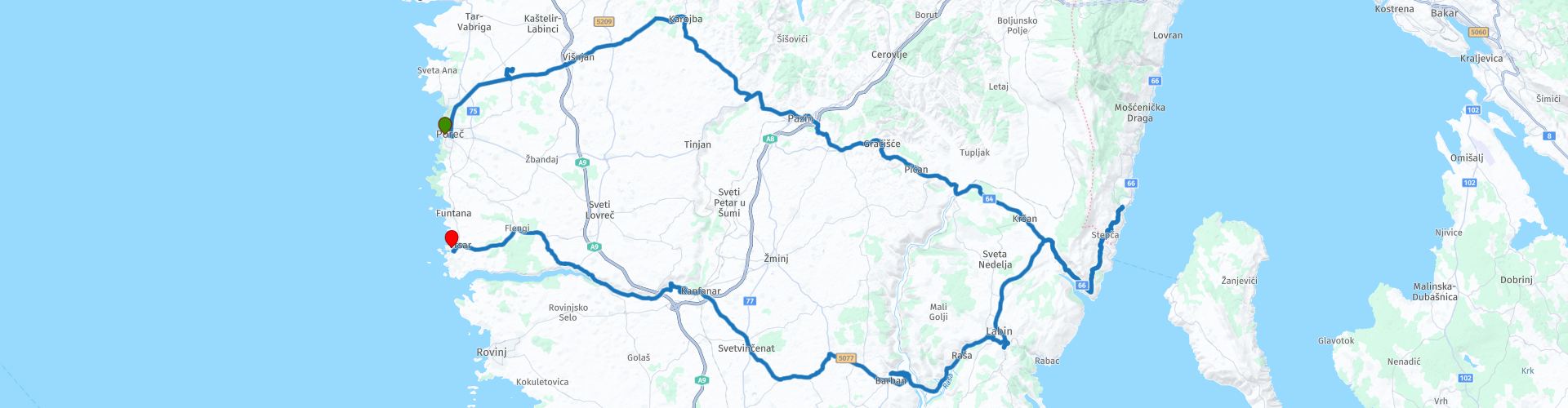
 This is a route across the middle of the Istrian peninsula, starting in Poreč. It ends via a loop, which takes in the eastern side of Istria and also on the western side in the Adriatic coastal town of Vrsar.
Large parts of Poreč have remained intact over the centuries. This makes the Roman and Venetian buildings look authentic. The most famous building is the Euphrasian Basilica. This basilica was built in the sixth century AD and is named after the Byzantine bishop Euphrasius. In 1997, this building was placed on the UNESCO World Heritage List. This underlines the historical value of the building. Between the 12th and 19th centuries, Poreč also had city walls, but these have since disappeared.
The Baredine Cave is a stalactite cave near Poreč, which was formed over thousands of years. It is one of the most beautiful caves in Istria and was opened to the public in 1995, just over twenty years after its discovery. The Baredine Caves consist of five different chambers at a depth of no less than sixty metres. The deepest chamber is even ten metres high. A visit to the caves will reveal a hidden world of stalagmites and stalactites.
One of the best things to do in Pazin is to visit the Kaštel, which is also the symbol of the town. It is the best preserved and the oldest castle in Istria. It is located on a 100-meter high cliff and looks truly spectacular. You can also find the Pazin City Museum there, where you can learn more about the history of the town and the history of the Istria region in Croatia. If you are looking for an adrenaline rush, you should definitely stop by the zip line. Zip-lining over the Pazin Cave is a unique experience. The cave is located at the end of the Pazinčica River canyon. Pazin Cave is the source of many legends and stories. There are several waterfalls around Pazin, but out of all the waterfalls, you should definitely tick off two – the Sopot waterfall and the one in the Pazinčica Valley, where we can find the Pazinski and Zarečki Krov, which are part of the Natura 2000 ecological network.
The village of Gračišće has several interesting sights, including the Church of the Mother of God on the Square, built in 1425, the small Church of St. Anthony of Padua and the Church of St. Euphemia built in 1383. In the Church of St. Euphemia there is a very impressive crucifix from the 13th century and a golden Baroque altar. The successive reconstruction of the Church of St. Euphemia did not change the essential features of medieval architecture. Many residential buildings were built in the 15th century, as evidenced by the dates engraved on the portals. In the Middle Ages it was surrounded by fortifications and one of the towers and the main city gates still stand. The parish church of St. Vitus was built in 1769. The "Palace of Salamon" is the only example of a Gothic residence in this part of Istria. The lowest floor of the freestanding tower contains a Romanesque doorway, suggesting that it could be one of the earliest buildings. Treasure trove of cultural heritage
The medieval town of Gračišće was surrounded by strong walls. The fortification system was developed from the 12th to the 16th century, and the walls are still partially preserved on the western, northern and eastern sides of the town. As part of them, the Romanesque town gate on the western side and the round Renaissance tower from 1500 on the eastern corner have been preserved. Through the town gate you enter the lodge dating back to 1549, next to which is a fontik, which is a storehouse for flour and grain used by the population to feed themselves in case of famine. Within the defensive walls, the urban structure of the town is somewhat different from other Istrian towns of that time, which makes Gračišće particularly impressive today. Instead of one main square, Gračišće is divided into town districts, each of which has its own square with a church, which is why it is listed in the Register of Cultural Property.
Pićan is a small settlement, located in the central part of Istria, near the town of Labin, surrounded by soft and green fields, forests, meadows and vineyards. In the area of Pićan about 2000 inhabitants live mainly in agriculture and tourism. Every year Pićan organizes Legendfest, a festival of folk tales, customs, legends and fairy tales of Istria. The festival lasts for three days and you can enjoy various concerts, theater performances, performances and paintings. Pićan is known for its imposing bell tower in the center of the place, which was built in 1872 from white limestone. It is 48 meters high and is one of the highest in Istria, but also the most beautiful.
Kršan is a picturesque medieval village located on the eastern side of the Istrian peninsula, at the foot of the slopes of Mount Učka, and is located 11 kilometers from Labin. The village grew up around a medieval castle, now one of the best preserved in Istria. The municipality of Kršan has access to the sea in the Plomin Bay and the small fishing village of Plomin Luka. Gastronomic specialties of this region, such as Istrian ham and cheese, Istrian soup and Kvarner scampi, can be tried in local taverns and restaurants.
Originally a Roman settlement, Plomin was abandoned after World War II, as the bay became too muddy and the inhabitants, mainly Italians, emigrated to Italy. However, it has since been repopulated and is now home to around 130 people. The buildings in the town are several hundred years old and built on the ruins of the original Roman houses. The walls date back to the 9th century. Plomin has two churches, St George the Elder and St George the Younger, with Christian art. St George the Elder houses the Plomin Tablet in its outer wall, a religious text from the 11th century written in the Glagolitic alphabet, the oldest known Slavic alphabet.
The medieval soul of Brseč, with its narrow alleys and passages, has been preserved to this day. Most of the houses were built in the 17th century, while the town walls, the fortress and the bell tower date back to the early Middle Ages. The castle, which is the historical town centre, is even older; the settlement was built around it later. The houses are an example of typical coastal architecture and on some of the houses you can still find plaques with Glagolitic letters. Like many other places, Brseč has its own olive mill from the 17th century. During this period, the parish priest of Brseč, Josip Mavrović, founded the Mašunerija building, a residential building with many rooms, workshops and a lodge. He is also responsible for the renovation of the parish church. Šterna - the town well - is located on the central square of the old town. Another part of the square is the school building, built in 1868.
Labin has a beautiful main square, Titov Trg. Here is the best place to start exploring Labin. There are also some free parking lots nearby, where you can easily leave your vehicle. Right on the square are several restaurants and a very good coffee house, where you can watch the hustle and bustle with delicious tiramisu and good cappuccino.
The main gate of St. Florus is the first sight you can see before entering the medieval old town. This beautiful city gate was built as early as 1589 and is still one of the most important sights in Labin. Very interesting is also the stone lion Serenissime on the archway, which is a remnant of the Venetian rule. The Republic of Labin was a republic between March 2 and April 8, 1921, proclaimed and governed by miners and peasants, as a result of a strike and subsequent uprising. In regional historiography, this revolt is seen as the first anti-fascist uprising ever.
Svetvinčenat is a small, picturesque town, located in the interior of the southern part of Istria, about halfway between Pula and Rovinj. Named after Saint Vincent and the Benedictine abbey of the same name around which the town gradually developed. Until the late 18th century, under the leadership of Venice and Venetian noble families, the town was further expanded. The large castle in the center of the main square, Grimani Castle is one of the most beautiful and best preserved Venetian buildings of that time in Istria, and consists of 3 towers, large mansions and high walls that connect them. The main square is another Renaissance gem, where is the parish church of the Annunciation, also from the 16th century.
In the time of the Illyrians, two colonies were founded in Dvigrad, after the Roman occupation the castle was not used for more than seven centuries. In the Middle Ages the colonies were merged into a town called Due Castelli or Twin Town; today's Dvigrad. The castle and the fortified town were rebuilt and between the fourteenth and sixteenth centuries it was a prosperous town with more than 1000 inhabitants. Dvigrad was then regularly attacked mainly because of its strategic location near the Lim Valley; a water-rich and fertile area. At the beginning of the seventeenth century the town was attacked and plundered by the Uskoks; the Croatian freedom fighters.
The inhabitants defended themselves quite well against the attack and the Uskoks quickly left with their booty. In the seventeenth century, however, there were regular malaria outbreaks and many inhabitants died (80%). In 1714, the last inhabitants left the town of Dvigrad, they emigrated to the village of Kanfanar.
The Lim Valley is the 35 km long valley of the Pazinčica River, which flows into the Lim Channel, a 10 km long estuary. Estuaries and coastal waters are among the most productive ecosystems on Earth, providing ecological, economic, cultural and aesthetic benefits. The 1958 film The Vikings starring Kirk Douglas was filmed here. The area around the channel has been inhabited since the Neolithic period. Under the Romans, the channel formed the border between the administrative units of Poreč and Pula. At the beginning of the 11th century, it was home to the hermit St. Romuald who founded the Monastery of St. Michael at Kloštar. Today, the 105 m long Cave of St. Romuald is open to visitors in the summer. Fishing in the Lim Channel has always been excellent. Now, the natural species have increased due to farmed mussels and oysters, which are offered in two excellent restaurants on the channel.
Your destination Vrsar is one of the special villages of Croatia. The village is very popular with tourists because of the small charming streets and the islands off the coast with special vegetation. Vrsar is already a very old place. The Romans already managed to conquer the old town after which it was plundered during the fall of the Roman Empire by the Goths. In 538 it belonged to the great Byzantine Empire. The Vatican was also among the rulers. The bishops of Porec had their country house here and left their mark on the small town. Considerable investments were made in beautiful houses and beautiful squares. You can still see that splendor and magnificence in the cozy town today. There is the Romanesque Maria Basilica and the old city gate to admire. But the terraces are also not to be missed.


 Links
Links  Usage
Usage Want to download this route?
You can download the route for free without MyRoute-app account. To do so, open the route and click 'save as'. Want to edit this route?
No problem, start by opening the route. Follow the tutorial and create your personal MyRoute-app account. After registration, your trial starts automatically.  Disclaimer
Use of this GPS route is at your own expense and risk. The route has been carefully composed and checked by a MyRoute-app accredited RouteXpert for use on TomTom, Garmin and MyRoute-app Navigation.
Changes may nevertheless have occurred due to changed circumstances, road diversions or seasonal closures. We therefore recommend checking each route before use.
Preferably use the route track in your navigation system. More information about the use of MyRoute-app can be found on the website under 'Community' or 'Academy'.

Istria
About this region
Istria ( ISS-tree-ə; Croatian and Slovene: Istra; Istriot: Eîstria; Istro-Romanian, Italian and Venetian: Istria), formerly Histria (Latin), Ἴστρια (Ancient Greek), is the largest peninsula within the Adriatic Sea. The peninsula is located at the head of the Adriatic between the Gulf of Trieste and the Kvarner Gulf. It is shared by three countries: Croatia, Slovenia, and Italy. Croatia encapsulates most of the Istrian peninsula with its Istria County.
Read more on Wikipedia
View region
 Statistics
  5
5Amount of RX reviews (Istria )
 4293
4293Amount of visitors (Istria )
 88
88Amount of downloads (Istria )
 Route Collections in this region
 Istria you know
This collection consists of a series of three rides, spread across the entire peninsula.
The first one goes through the north of Istria and starts in Opatija on the eastern side of the Kvarner and ends in Porec on the western coast of the Gulf of Trieste.
The second route goes through the middle part of the Istrian peninsula, starting in Poreč. It ends via a loop, which takes in the eastern side of Istria and also on the western side in the Adriatic coastal town of Vrsar.
The third stage takes in the south of Istria. The tour starts in Rovinj on the west coast of the Gulf of Trieste and ends in Rabac on the east side of the Kvarner
Istria in Croatia is located on the northeastern part of the Adriatic Sea. Istria is proud of its miles of coastline full of dazzling beaches and its green inland full of forests and vineyards. During a stay in Istria, you will also find numerous villages and towns that breathe culture and history. The beauty and diversity of the region make Istria a popular holiday destination. For sun worshippers, for culture lovers, but also for those who love adventurous, but also exciting roads.
View Route Collection