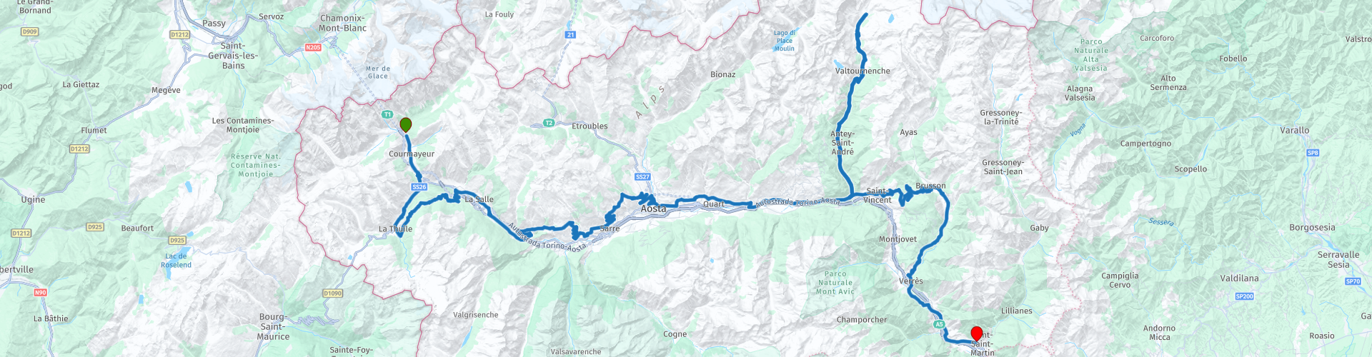
Courmayeur to Pont Saint Martin along the Valle dAosta

This route was brought to you by:
RouteXpert Nick Carthew - (MRA Master)
Last edit: 24-01-2024
 Route Summary
 The spectacular mountain views and historic sites makes this route worthy of the 5***** stars I have awarded it.
 Share this route


Animation

Verdict


Duration
5h 36m

Mode of travel
Car or motorcycle

Distance
223.58 km

Countries

 RouteXpert Review
 The smallest region in Italy encompasses the most beautiful and highest mountains in the area such as Mont Blanc, Monte Rosa, the Matterhorn and Gran Paradiso
This route is a feast for your eyes and has breathtakingly beautiful views along it's entire stretch. You are never far away from the river Dora Baltea that runs through the Valle d'Aosta. This 170 km river has its source in Mont Blanc area where the Dora di Val Ferret joins with the Dora di Val Veny. As the river travels through the Aosta Valley, the Dora Baltea River crosses through the city of Courmayeur, Aosta and Saint-Vincent, soon after, the river reaches the River Po, close to Chivasso.
The route starts from a nice hotel just on the Italian side of the Mont Blanc tunnel and soon crosses the river Dora Baltea and uses the Strada Statale 26 road which has some fantastic hairpin bends, tunnels and magnificent views as it makes it's way to La Thuile. Here you'll find a great little cafe with dedicated parking for motorcycles and a warm welcome. More great bends and the highest point of this route (Colle San Carlo at 1970 m) will be found as you make your way back to the Aosta Valley floor. This route avoids the major roads as much as it can in preference to the more twisty provincial roads. You will pass castles and have many opportunities to stop for photographs of the breathtaking views.
I have suggested a lunch stop at Aosta.
Aosta is an old Roman town at 583m above sea level, and the largest in the region with a population of 35,000. Full of things to see and do, it’s surrounded by magnificent mountains, including the Grand Combin and the Mont Vélan to the north, Emilius and the Becca di Nona to the south, and the Testa del Rutor to the west. The town was founded by the Romans in 25 BC at a geographical point where the physiographic catchment of the Dora Baltea reaches its maximum width, and where the main roads heading to France and Switzerland converge. The presence of the Piccolo and Gran San Bernardo Alpine hills makes Aosta an important strategic junction from a transport point of view (nowadays thanks to the Mont Blanc and Gran San Bernardo Tunnels). Rich in monuments from prehistoric, Roman, medieval and later times, Aosta makes a fascinating historical case study. There’s the megalithic area of Saint-Martin de Corleans; the Praetoria Gate, one of the few examples from Roman times still perfectly intact; the Theatre; the forum Cryptoporticus, the perimeter of the boundary walls almost completely intact; a well-preserved extra muros villa; and the magnificent Augustus’ Arch. Ancient roads, fountains, wash-houses, votive chapels, sundials, historical houses and courtyards are also in abundance.
There is an abundance of restaurants close to the Arco di Augusto to suit all tastes
At RP32 you have the option to ride to the Matterhorn mountain, a round trip of 1.5 - 2 hours with a coffee stop.
Thanks to its shape and its free-standing position, the Matterhorn is considered to be the epitome of a mountain. There is no better known mountain in the world whose natural shape is so close to a pyramid. 100 million years ago, enormous forces brought Africa closer to Europe. 50 million years later, as the rock masses folded and deformed, the Matterhorn was born from the rock thrusting upwards. The valley road leading to the Matterhorn has some incredibly beautiful views and is of course, completely different when you turn around and ride back down the other way.
After rejoining the Aosta valley the route heads into the hills again and on to the Colle di Joux, and at 1650 m it's the second highest peak of this route.
More beautiful views, twisty roads and castles bring you to perhaps the most imposing of all of the fortifications within the Aosta Valley; Fort Bard.
The fort, which is at the eastern entrance to the Aosta Valley, is located in a narrow gorge above the Dora Baltea river. It has been used for millennia to control the historic route between Italy and France. The current fortifications were built by Charles Albert of Savoy between 1830 and 1838. It replaced a 10th-century castle that had, itself, been built on an earlier structure founded by Theodoric I in the 5th century. The castle was under the control of the powerful local lords of Bard until the middle of the 13th century when ownership passed to the House of Savoy. Under their control, the defences were strengthened and improved. On May 14, 1800, a 40,000-strong French army was stopped by 400 Austro-Piedmontese soldiers at Fort Bard. They held the pass for two weeks, completely ruining Napoleon Bonaparte's plan of making a surprise attack on the Po Valley and Turin. When he heard the news, he named the fort vilain castel de Bard. Bonaparte then ordered the fort to be razed to the ground. It was not until 1830 that Charles Albert of Savoy, fearing new attacks from the French, ordered that the fort be rebuilt.
This route ends at Hotel Crabun which is just a few minutes away. Links for the start and end hotels can be found below this review and of course, there are many more choices of accommodation available.


 Links
Links  Usage
Usage Want to download this route?
You can download the route for free without MyRoute-app account. To do so, open the route and click 'save as'. Want to edit this route?
No problem, start by opening the route. Follow the tutorial and create your personal MyRoute-app account. After registration, your trial starts automatically.  Disclaimer
Use of this GPS route is at your own expense and risk. The route has been carefully composed and checked by a MyRoute-app accredited RouteXpert for use on TomTom, Garmin and MyRoute-app Navigation.
Changes may nevertheless have occurred due to changed circumstances, road diversions or seasonal closures. We therefore recommend checking each route before use.
Preferably use the route track in your navigation system. More information about the use of MyRoute-app can be found on the website under 'Community' or 'Academy'.

Valle d Aosta
About this region
The Aosta Valley (Italian: Valle d'Aosta [ˈvalle daˈɔsta] (official) or Val d'Aosta (usual); French: Vallée d'Aoste; Arpitan: Val d'Outa; Walser: Augschtalann or Ougstalland; Piedmontese: Val d'Osta) is a mountainous autonomous region in northwestern Italy. It is bordered by Auvergne-Rhône-Alpes, France, to the west, Valais, Switzerland, to the north, and by Piedmont, Italy, to the south and east. The regional capital is Aosta.
Covering an area of 3,263 km2 (1,260 sq mi) and with a population of about 128,000 it is the smallest, least populous, and least densely populated region of Italy. The province of Aosta having been dissolved in 1945, the Aosta Valley region was the first region of Italy to abolish provincial subdivisions. Provincial administrative functions are provided by the regional government. The region is divided into 74 comuni (French: communes).
Italian and French are the official languages, though the native population also speak Valdôtain, a dialect of Franco-Provençal. Italian is spoken as a mother tongue by 77.29% of population, Valdôtain by 17.91%, and French by 1.25%. In 2009, reportedly 50.53% of the population could speak all three languages.
Read more on Wikipedia
Covering an area of 3,263 km2 (1,260 sq mi) and with a population of about 128,000 it is the smallest, least populous, and least densely populated region of Italy. The province of Aosta having been dissolved in 1945, the Aosta Valley region was the first region of Italy to abolish provincial subdivisions. Provincial administrative functions are provided by the regional government. The region is divided into 74 comuni (French: communes).
Italian and French are the official languages, though the native population also speak Valdôtain, a dialect of Franco-Provençal. Italian is spoken as a mother tongue by 77.29% of population, Valdôtain by 17.91%, and French by 1.25%. In 2009, reportedly 50.53% of the population could speak all three languages.
View region
 Statistics
  6
6Amount of RX reviews (Valle d Aosta)
 13472
13472Amount of visitors (Valle d Aosta)
 188
188Amount of downloads (Valle d Aosta)
 Route Collections in this region
 Tour around Switzerland
The Alps, a mountain range in Europe that stretches from the French Mediterranean coast in the southwest to the Pannonian plain in the east, almost always guarantee beautiful routes. It can hardly be boring there. The many passes, vistas and variations in the landscape make the Alps a true motorcycle paradise.
Switzerland is centrally located in this paradise and is surrounded on all sides by countries with beautiful steering on fantastic roads.
The 7 routes of this collection lead you around Switzerland, of course this beautiful country is also visited. You pass through beautiful areas such as the Alps, the French and Swiss Jura and the Black Forest.
A few sights are discussed in the review for each route. These often tell something about the history of the area in which you drive. So instructive. Many places are also marked where you can find some entertainment, for example a toboggan run. You are completely free to visit these sights, you can of course also determine your own points of interest.
But the main thing you probably traveled to this area for is simply driving. And as mentioned above, you are in a true motorcycle paradise where the steering is fantastic!
Each route ends at a hotel (except the last one which ends at the train station in Innsbruck). It is of course not an obligation to use these hotels, you can always find another place to stay in the area, that is entirely up to you. My experience, however, is that they are all simple but good hotels for a very reasonable price. They are known and can be booked through booking.com.
The routes of these collections:
R01 - Innsbruck to Chiuro, 301km
R02 - Chiuro to Brig, 279km
R03 - Brig to Bourg Saint Maurice, 288km
R04 - Bourg St Maurice to St Etienne de Cuines, 307km
R05 - St Etienne de Cuines to Metabief, 295km
R06 - Metabief to Fuerstenberg, 305km
R07 - Fuerstenberg to Innsbruck, 335km
Have fun driving these routes!
View Route Collection