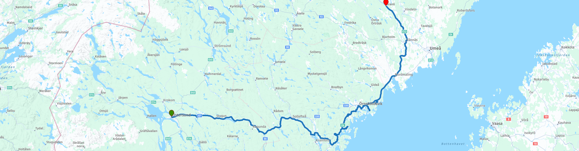
04 Ostersund to Grano

This route was brought to you by:
RouteXpert Leon Bodegom
Last edit: 04-04-2021
 Route Summary
 This was part 4 of our 2019 tour and introduction to Sweden. There is plenty to see and visit along the way. However, keep in mind the opening times of places to visit. The tourist season is short and in various places the sights were sometimes only opened after Whit Monday. In this part there are several beautiful stops for a visit and even though the number of daylight hours is high in the summer, the days are still short to see everything. Sometimes you will have to think before the start of the ride where you spend the time to visit the mentioned places. Use the links in the review to the various websites for the current opening hours.
At the end of this route, the sun will rise at 2:24 am on June 30 and set again at 10:59 pm.
That is 3 hours earlier and an hour later compared to Utrecht.
Beautiful roads, curves, rivers, alternate with forests and green hills.
In Jamtland you have the best chance of spotting Sweden's Big Five. Bears, Wolves, the wolverine, the lynx and the moose that live here.
Start: Ostersund, Clarion Grand hotel
End: Grano, Beckasin lodges and campground
I have awarded this route with 3 *** stars because the rolling forest landscape is pleasant and quiet to drive, the roads are generally good and the various attractions very good.
 Share this route


Animation

Verdict


Duration
14h 26m

Mode of travel
Car or motorcycle

Distance
488.31 km

Countries

 RouteXpert Review
 On this route in the sparsely populated part of Sweden, the places of residence are getting smaller and the number of possible stops for coffee or lunch is also limited. Therefore again the advice to bring something to drink and eat on this part of the route in case the eateries have a rest day.
There are also plenty of places for a picnic in this quiet area. Drive onto a side road and you imagine yourself alone in the world.
The city of Ostersund leaves you behind and you drive parallel to the river Indalsalven to the east coast. Norway is known for its stave churches, but you can also see this architectural style in Sweden. After half an hour you will leave the main road at Lillsjöhögen for a short while and a short photo stop is planned at the stave church in Lillsjöhögen.
The next part of the route you first have the Indalsalven on your left and after the crossing at Stugun the river on your right. Because the river further on has been dammed by a dam for electricity generation, this part of the river has been turned into a reservoir. There is a museum at the dam and you can also use it for a coffee stop.
The course of the water was modified in 1800 in order to be able to use the river for transporting tree trunks. You can see how that was done back then when you visit Doda fallet. There you can take a walk through the bed of the dried-up waterfall / rapids on easily accessible stairs and walkways.
The soil was removed by clever use of the water flow. That this did not always go well, it is explained there what disaster took place there.
From Gallsätter, the route follows the High Coasts. This piece of land in Sweden has risen after the pressure of the ice sheet on the subsurface has disappeared. A process that is still taking place, making this part of Sweden high above sea level. To get a better idea of this, it is best to visit the visitor center '' Naturum Hoga Kusten ''. Do not expect high rocks above the sea along the route, you will be able to take one of the many walks to the coast in the nature park. The route here meanders over a distance of 100 Km from one bay to another until you re-enter the E4. After all that swinging, this is a bit of a route to shoot, but after 30 KM you leave the E4 again.
You drive back into the hills and forests to the town of Vannas. Here you will find another refueling facility to refuel for the next day. In the village, take a short tour past the old wooden railway building, behind which a large steam locomotive is still standing. Here in Vannas is also the last opportunity to do some shopping before arriving at the overnight stop in Grano.
For camping enthusiasts, there is also a camping pitch at the final destination. This location has cottages, tree houses, a lodge and a campground on the waterfront. There is also a camping site in Vannas.
Except for endless cruising on quiet roads, there is also plenty to see on this route.


 Links
Links  Usage
Usage Want to download this route?
You can download the route for free without MyRoute-app account. To do so, open the route and click 'save as'. Want to edit this route?
No problem, start by opening the route. Follow the tutorial and create your personal MyRoute-app account. After registration, your trial starts automatically.  Disclaimer
Use of this GPS route is at your own expense and risk. The route has been carefully composed and checked by a MyRoute-app accredited RouteXpert for use on TomTom, Garmin and MyRoute-app Navigation.
Changes may nevertheless have occurred due to changed circumstances, road diversions or seasonal closures. We therefore recommend checking each route before use.
Preferably use the route track in your navigation system. More information about the use of MyRoute-app can be found on the website under 'Community' or 'Academy'.

Jamtlands lan
About this region
Jämtland County (Swedish: Jämtlands län, Southern Sami: Jiemthen leene) is a county or län in the middle of Sweden consisting of the provinces of Jämtland and Härjedalen, along with minor parts of Hälsingland and Ångermanland, plus two small uninhabited strips of Lapland and Dalarna. Jämtland County constitutes 12 percent of Sweden's total area, 49,443 km2 (19,090 sq mi) and is the third largest county in the country. The county capital is Östersund and the county governor, appointed by the Swedish government, is Jöran Hägglund, who leads the administrative board. Jämtland County borders the counties of Dalarna, Gävleborg, Västernorrland, and Västerbotten. It also shares a border with the Norwegian county of Trøndelag.
The county was established in 1810 and its foundation has both domestic and foreign causes. Upon formation it only consisted of the provinces of Jämtland and Härjedalen, which is why the coat of arms is a shield parted per fess with their provincial arms.
Being sparsely populated, the land area of Jämtland County is larger than those of the Netherlands and Switzerland.
Read more on Wikipedia
The county was established in 1810 and its foundation has both domestic and foreign causes. Upon formation it only consisted of the provinces of Jämtland and Härjedalen, which is why the coat of arms is a shield parted per fess with their provincial arms.
Being sparsely populated, the land area of Jämtland County is larger than those of the Netherlands and Switzerland.
View region
 Statistics
  2
2Amount of RX reviews (Jamtlands lan)
 7030
7030Amount of visitors (Jamtlands lan)
 82
82Amount of downloads (Jamtlands lan)