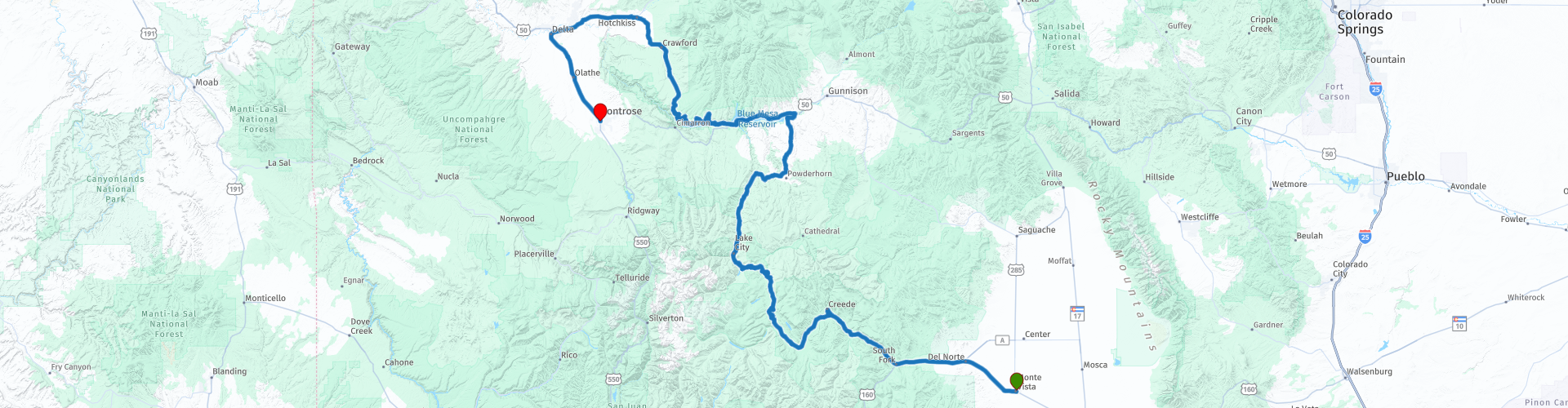
Monte Vista to Montrose

This route was brought to you by:
RouteXpert Paul Hedges - Adv RouteXpert
Last edit: 16-04-2020
 Route Summary
 This is a day or long rivers and mountains on all sides. A day of constantly changing vistas along each turn in the road. 4 Star Day all the way
 Share this route


Animation

Verdict


Duration
5h 45m

Mode of travel
Car or motorcycle

Distance
422.20 km

Countries

 RouteXpert Review
 Leaving Monte Vista on Highway 165 the road is joined by the Rio Grande, this is the at the beginning of the 1900 mile journey as it makes its way to the Gulf of Mexico. At South Fork we head north along through the Rio Grande Valley. For 40 miles Route 149 follows the Rio Grande River, the open winding valley delivering a constantly changing landscape under a wide-open sky.
Pull over at the Wagon Wheel Gap Interpretive for an opportunity to see the Rio Grande River and learn history of the area at interpretive signs. Keep an eye out for bighorn sheep along the cliffs.
Further along the valley take a break at North Clear Creek Falls, these waterfalls feel out of place amongst the arid surroundings.
A break in Lake City and it is more open skies as the road just keeps delivering a new view around each corner.
Reaching the Great Mesa Reservoir Route 50 sits alongside taking you to the Great Mesa Dam.
Joining Colorado 90 the road starts to climb and for 30 miles the road twists and turns offering never-ending views of the river below.
The 90 continues to share vista after vista as the road seems to ever stay at one level all the way to Hotchkiss. After a fuel break head west towards Delta before turning south on Route 50 to Montrose where the day ends.
Stunning scenery and wonderful riding roads makes this a 4 star day


 Links
Links  Usage
Usage Want to download this route?
You can download the route for free without MyRoute-app account. To do so, open the route and click 'save as'. Want to edit this route?
No problem, start by opening the route. Follow the tutorial and create your personal MyRoute-app account. After registration, your trial starts automatically.  Disclaimer
Use of this GPS route is at your own expense and risk. The route has been carefully composed and checked by a MyRoute-app accredited RouteXpert for use on TomTom, Garmin and MyRoute-app Navigation.
Changes may nevertheless have occurred due to changed circumstances, road diversions or seasonal closures. We therefore recommend checking each route before use.
Preferably use the route track in your navigation system. More information about the use of MyRoute-app can be found on the website under 'Community' or 'Academy'.